植物生态学报 ›› 2008, Vol. 32 ›› Issue (2): 328-335.DOI: 10.3773/j.issn.1005-264x.2008.02.009
Khajeddin SJ1( ), Akbari M1, Karimzadeh HR1, Eghbal MK2
Khajeddin SJ1(), Akbari M1, Karimzadeh HR1, Eghbal MK2
摘要:
Aims Desertification results in ecological and biological diminution of the earth, and can happen naturally or cause by anthropogenic activities. This process especially affects arid and semi-arid regions, such as the Isfahan region, where the spread of desertification is reaching critical proportions. The aim of this study is to use remotely sensed data to review the trend of desertification in the northern of Isfahan, Iran.
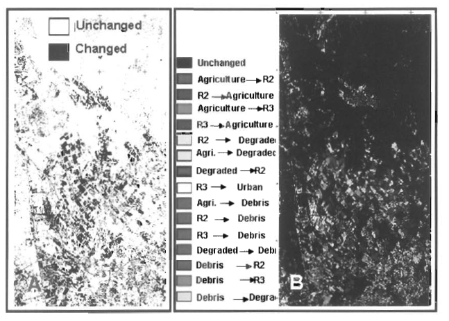
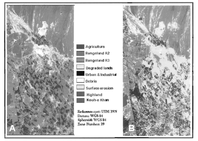
Methods Multi-temporal images were employed to evaluate the trend of desertification, specifically the TM and ETM+ data of September, 1990 and September, 2001. Geometric and radiometric corrections were applied to each image prior to image processing and supervised classification, and vegetation indices were applied to produce a land use map of each image in nine classes. The land use classifications in the two map images were compared and changes between land use classes were detected over the 11 year period using a fuzzy and post-classification technique.
Important findings The maps and their comparison with false color composite images showed the differences efficiently. With the fuzzy and post-classification method the land use changes were sited on the map. Fuzzy confirmed 53% changed area and 47% unchanged areas in the study region. The results verify the desertification expansion in the study areas. Because of poor land management, agricultural lands converted to desert and abandoned areas, and some marginal pasture lands had to be changed to agricultural land which are desertification spreading according to United Nations Conference on Desertification (UNCOD). Also farmland and pastures have been converted to urban and industrial areas, and the rangelands have been spoiled due to opencast mine excavations. With the mine margins eroding as well as their debris accumulating on the pasture lands, desertification has become worse. Three areas of less-elevated mountains have remained unchanged. This study confirmed that the anthropogenic activities accelerated the desertification process and severely endangered the remaining areas.