
植物生态学报 ›› 2012, Vol. 36 ›› Issue (11): 1125-1135.DOI: 10.3724/SP.J.1258.2012.01125
所属专题: 青藏高原植物生态学:遥感生态学
• 研究论文 • 下一篇
周磊1,2, 何洪林1,*( ), 张黎1, 孙晓敏1, 石培礼1, 任小丽1,2, 于贵瑞1
收稿日期:2012-08-08
修回日期:2012-09-22
出版日期:2012-08-08
发布日期:2012-11-09
通讯作者:
何洪林
作者简介:(E-mail: hehl@igsnrr.ac.cn)
ZHOU Lei1,2, HE Hong-Lin1,*(), ZHANG Li1, SUN Xiao-Min1, SHI Pei-Li1, REN Xiao-Li1,2, YU Gui-Rui1
Received:2012-08-08
Revised:2012-09-22
Online:2012-08-08
Published:2012-11-09
Contact:
HE Hong-Lin
摘要:
物候现象是环境条件季节和年际变化最直观、敏感的综合指示器, 其发生时间不仅反映了陆地生态系统短期的动态特征, 其微小的变化还会对陆地生态系统产生重要的反馈作用。高寒草地是青藏高原分布广泛、极具代表性的植被类型, 准确地获取高寒草地群落的物候特征, 对于理解和预测气候变化对青藏高原生态系统的影响具有重要意义。该文以西藏当雄高寒草地为研究对象, 探讨了近地面数字相机图像在高寒草地群落季相监测中的作用, 结果如下: 1)通过比较不同绿度指数的差别, 确定了准确表征高寒草地植被群落季相变化的绿度指数——绝对绿度指数(2G_RB); 2)结合土壤含水量数据, 通过线性回归分析得知高寒草地植被群落生长过程与表层(≤10 cm)土壤含水量的变化较为一致(R 2 > 0.70); 3)通过对比分析, 发现降水在高寒草地群落季相“变绿”过程中具有“触发”作用。研究表明, 数字相机技术可作为物候监测手段, 实现高寒草地植被群落季相的实时、连续获取, 为更好地揭示气候变化影响下景观尺度季相演变特征, 诊断地方、区域和全球尺度上生态系统对气候变化的快速响应提供了有效的手段。
周磊, 何洪林, 张黎, 孙晓敏, 石培礼, 任小丽, 于贵瑞. 基于数字相机图像的西藏当雄高寒草地群落物候模拟. 植物生态学报, 2012, 36(11): 1125-1135. DOI: 10.3724/SP.J.1258.2012.01125
ZHOU Lei, HE Hong-Lin, ZHANG Li, SUN Xiao-Min, SHI Pei-Li, REN Xiao-Li, YU Gui-Rui. Simulations of phenology in alpine grassland communities in Damxung, Xizang, based on digital camera images. Chinese Journal of Plant Ecology, 2012, 36(11): 1125-1135. DOI: 10.3724/SP.J.1258.2012.01125
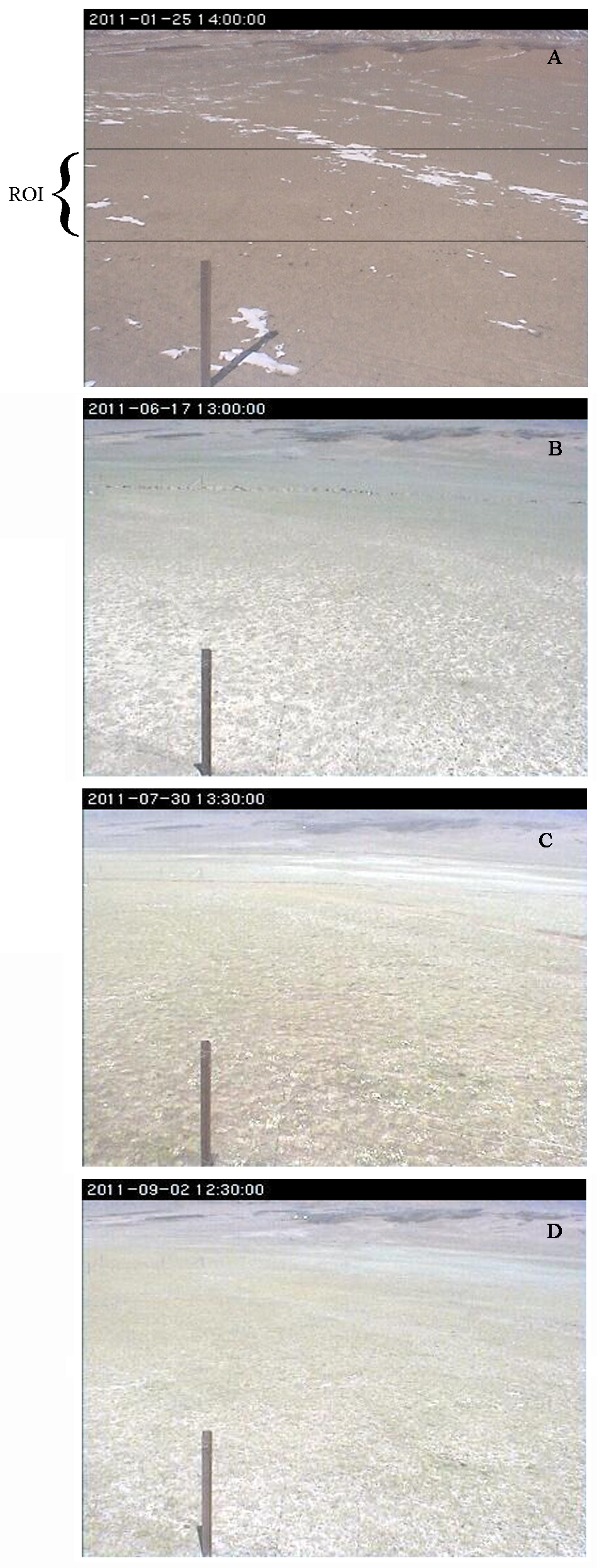
图1 高寒草地植被冠层不同季相的数字图像示例。 A, 休眠期初期(年序日第25天)。B, 变绿期初期(年序日第167天)。C, 旺盛期初期(年序日第211天)。D, 凋落期初期(年序日第245天)。ROI, 感兴趣区域。
Fig. 1 Digital images samples of alpine grassland vegetation canopy in different phenological phase. A, Beginning of dormancy stage (DOY 25). B, Beginning of green-up stage (DOY 167). C, Beginning of maturity stage (DOY 211). D, Beginning of senescence stage (DOY 245). DOY, day of year; ROI, region-of-interest.
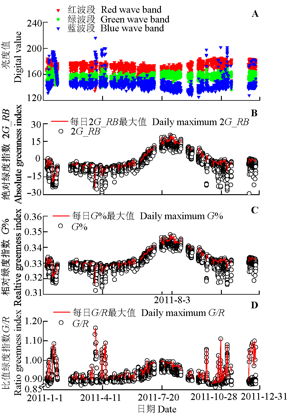
图2 感兴趣区域内各变量的时间序列。A, 各波段亮度值。B, 绝对绿度指数。C, 相对绿度指数。D, 比值绿度指数。
Fig. 2 Time series of variables for a region-of-interest (ROI). A, Digital values for different wave bands. B, Absolute greenness index. C, Relative greenness index. D, Ratio greenness index.
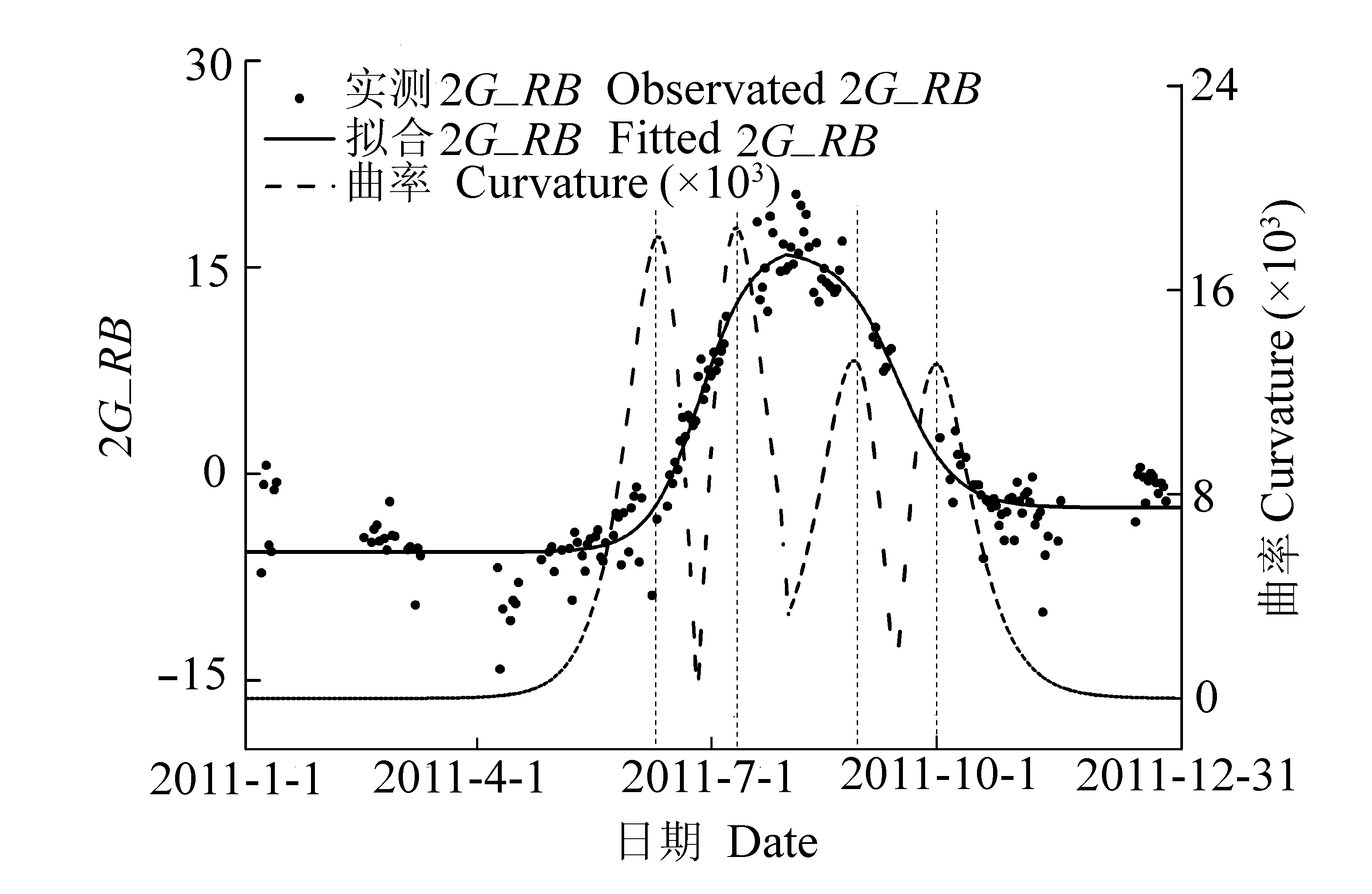
图3 绝对绿度指数(2G_RB)的实测值、拟合值的时间序列以及物候期的确定。
Fig. 3 Times series of observed absolute greenness index (2G_RB), fitted 2G_RB and determination of phenological phase.
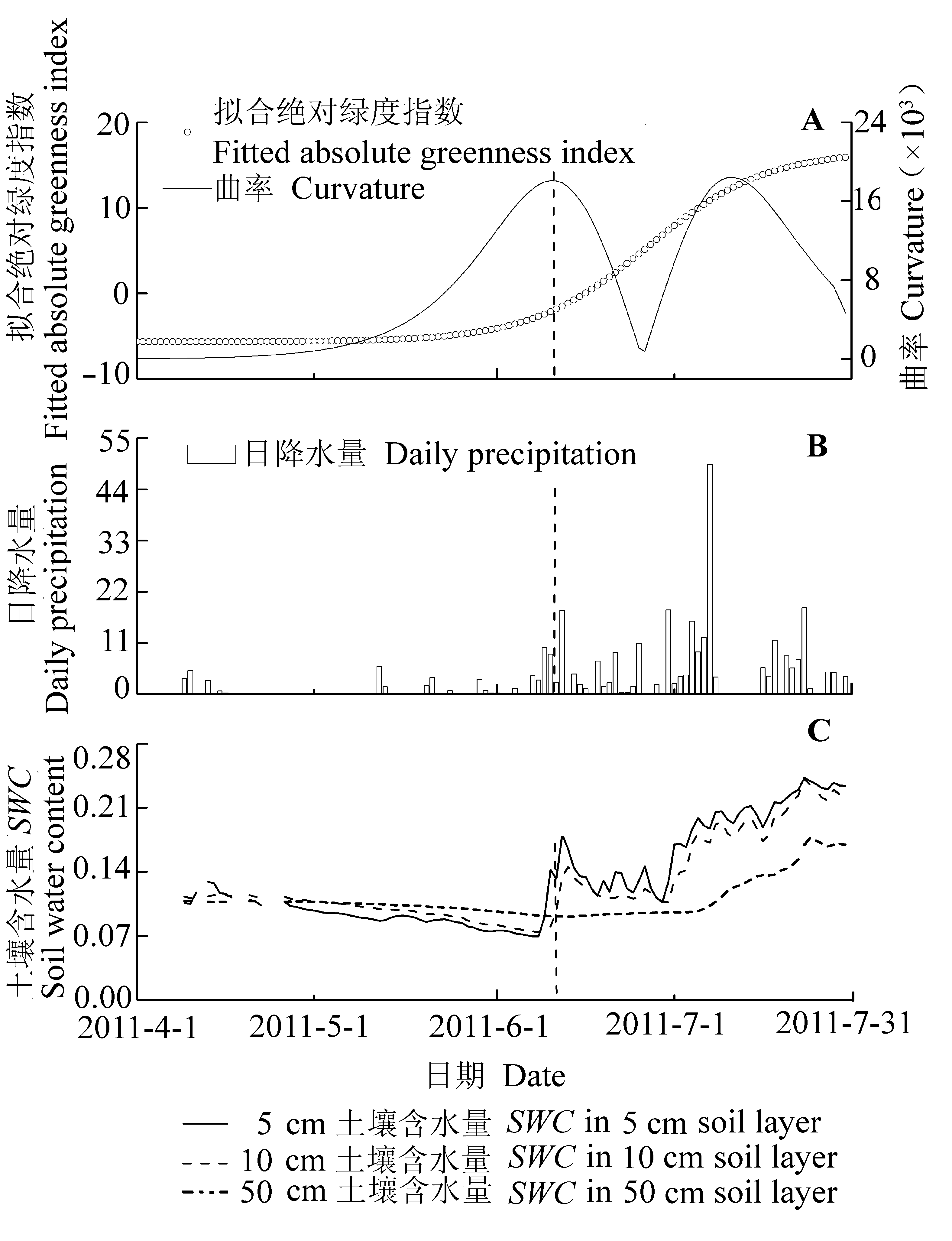
图4 2011年4月1日到7月31日拟合绝对绿度指数与常规气象数据的时间序列。
Fig. 4 Time series of fitted absolute greenness index and conventional metrological data from April 1 to July 31, 2011.
| 5 cm土层土壤含水量 Soil water content in 5 cm soil layer | 10 cm土层土壤含水量 Soil water content in 10 cm soil layer | 50 cm土层土壤含水量 Soil water content in 50 cm soil layer | |
|---|---|---|---|
| 斜率 Slope | 117.53 | 129.00 | 216.49 |
| 截距 Intercept | -12.33 | -13.34 | -21.51 |
| p值斜率 p-value slope | ≤0.01 | ≤0.01 | ≤0.01 |
| p值截距 p-value intercept | ≤0.01 | ≤0.01 | ≤0.01 |
| 决定系数 Coefficient of determination R2 | 0.74 | 0.71 | 0.64 |
表1 全年绝对绿度指数与各土层土壤含水量之间的线性回归分析
Table 1 Linear regression analysis between absolute greenness index and soil water content of different soil layers in the whole year
| 5 cm土层土壤含水量 Soil water content in 5 cm soil layer | 10 cm土层土壤含水量 Soil water content in 10 cm soil layer | 50 cm土层土壤含水量 Soil water content in 50 cm soil layer | |
|---|---|---|---|
| 斜率 Slope | 117.53 | 129.00 | 216.49 |
| 截距 Intercept | -12.33 | -13.34 | -21.51 |
| p值斜率 p-value slope | ≤0.01 | ≤0.01 | ≤0.01 |
| p值截距 p-value intercept | ≤0.01 | ≤0.01 | ≤0.01 |
| 决定系数 Coefficient of determination R2 | 0.74 | 0.71 | 0.64 |
| 数据获取平台 Data acquisition platform | 群落季相初日 Onset date of community phenological phase | |||
|---|---|---|---|---|
| 变绿期 Green-up stage | 成熟期 Maturity stage | 凋落期 Senescence stage | 休眠期 Dormancy stage | |
| 数字相机 Digital camera | 161 | 192 | 238 | 278 |
| 卫星 Satellite | 158 | 198 | 245 | 294 |
表2 不同数据来源获取的群落季相初日的比较(单位: 年序日)
Table 2 Comparison of community phenological phase onset derived from different data sources (unit: day of year)
| 数据获取平台 Data acquisition platform | 群落季相初日 Onset date of community phenological phase | |||
|---|---|---|---|---|
| 变绿期 Green-up stage | 成熟期 Maturity stage | 凋落期 Senescence stage | 休眠期 Dormancy stage | |
| 数字相机 Digital camera | 161 | 192 | 238 | 278 |
| 卫星 Satellite | 158 | 198 | 245 | 294 |
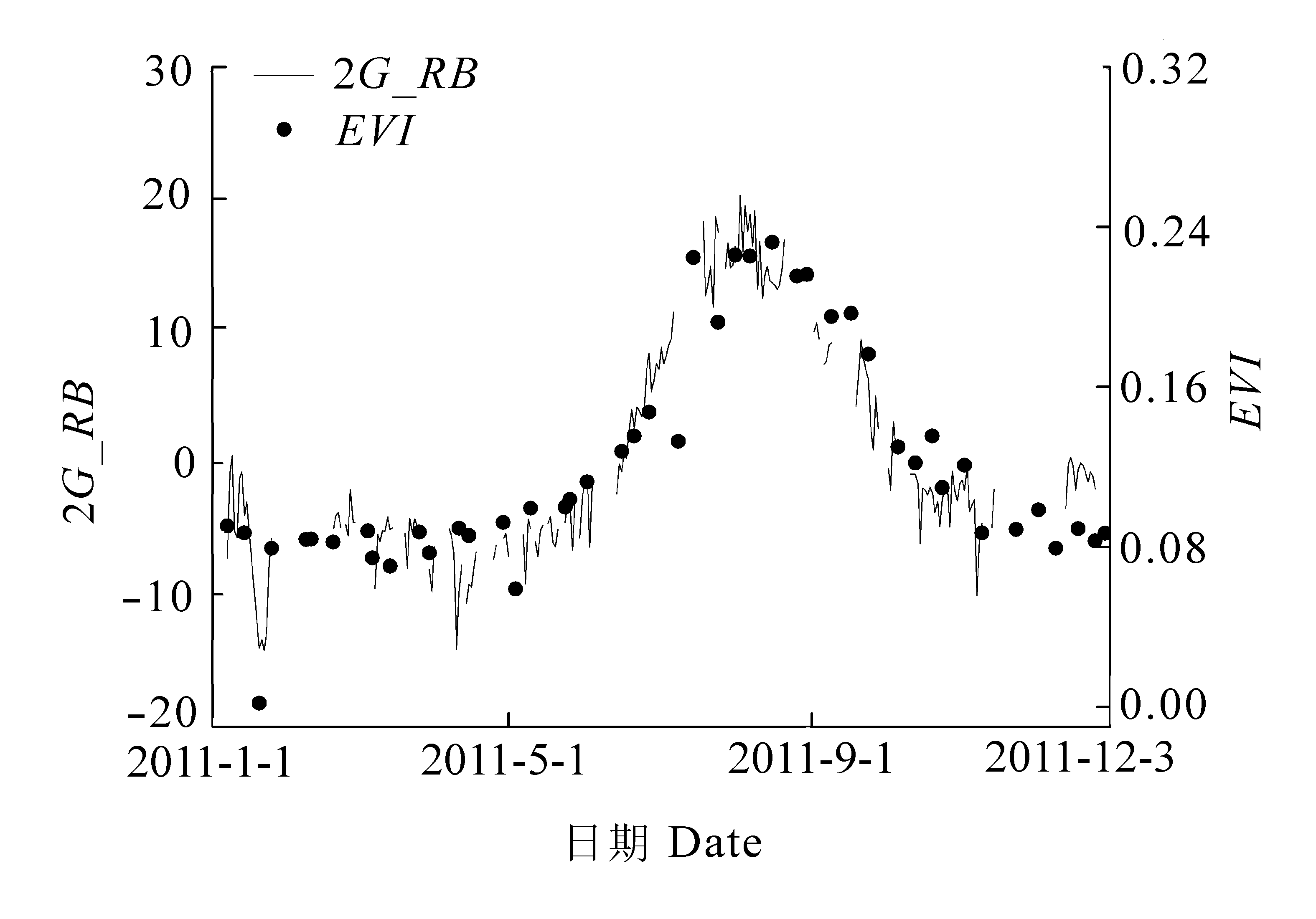
图5 绝对绿度指数(2G_RB)与增强型植被指数(EVI)的时间序列的比较。
Fig. 5 Time series comparison of absolute greenness index (2G_RB) and enhanced vegetation index (EVI).
| 1 |
Adamsen FG, Pinter PJ, Barnes EM, LaMorte RL, Wall GW, Leavitt SW, Kimball BA ( 1999). Measuring wheat senescence with a digital camera. Crop Science, 39, 719-724.
DOI URL |
| 2 | Ahrends HE, Brügger R, Stöckli R, Schenk J, Michna P, Jeanneret F, Wanner H, Eugster W ( 2008). Quantitative phenological observations of a mixed beech forest in northern Switzerland with digital photography. Journal of Geophysical Research-Biogeosciences, 113, G04004, doi: 10.1029/2007JG000650. |
| 3 |
Ahrends HE, Etzold S, Kutsch WL, Stoeckli R, Bruegger R, Jeanneret F, Wanner H, Buchmann N, Eugster W ( 2009). Tree phenology and carbon dioxide fluxes: use of digital photography for process-based interpretation at the ecosystem scale. Climate Research, 39, 261-274.
DOI URL |
| 4 |
Beatley JC ( 1974). Phenological events and their environ- mental triggers in Mojave Desert ecosystems. Ecology, 55, 856-863.
DOI URL |
| 5 |
Birch HF ( 1958). The effect of soil drying on humus decomposition and nitrogen availability. Plant and Soil, 10, 9-31.
DOI URL |
| 6 |
Campillo C, Prieto MH, Daza C, Moniño MJ, García MI ( 2008). Using digital images to characterize canopy coverage and light interception in a processing tomato crop. Hortscience, 43, 1780-1786.
DOI URL |
| 7 | Chen XQ ( 陈效逑), Li J ( 李倞 ) ( 2009). Relationships between Leymus chinensis phenology and meteorological factors in Inner Mongolia grasslands. Acta Ecologica Sinica (生态学报), 29, 5280-5290. (in Chinese with English abstract) |
| 8 |
Chmielewski FM, Rötzer T ( 2001). Response of tree phenology to climate change across Europe. Agricultural and Forest Meteorology, 108, 101-112.
DOI URL |
| 9 |
Chuine I ( 2000). A unified model for budburst of trees. Journal of Theoretical Biology, 207, 337-347.
DOI URL |
| 10 | Comprehensive Scientific Expedition to Qinghai-Xizang(Tibetan) Plateau, Chinese Academy of Sciences(中国科学院青藏高原综合科学考察队) (1988). Vegetation of Xizang (Tibet) (西藏植被). Science Press, Beijing. (in Chinese) |
| 11 |
Coops NC, Hilker T, Bater CW, Wulder MA, Nielsen SE, McDermid G, Stenhouse G ( 2012). Linking ground-based to satellite-derived phenological metrics in support of habitat assessment. Remote Sensing Letters, 3, 191-200.
DOI URL |
| 12 |
Crimmins MA, Crimmins TM ( 2008). Monitoring plant pheno- logy using digital repeat photography. Environmental Management, 41, 949-958.
DOI URL |
| 13 | Du J ( 杜军), Ma YC ( 马玉才 ) ( 2004). Climatic trend of rainfall over Tibetan Plateau from 1971 to 2000. Acta Geogra- phica Sinica (地理学报), 59, 375-382. (in Chinese with English abstract) |
| 14 |
Fisher JI, Mustard JF, Vadeboncoeur MA ( 2006). Green leaf phenology at Landsat resolution: scaling from the field to the satellite. Remote Sensing of Environment, 100, 265-279.
DOI URL |
| 15 | Graham EA, Hamilton MP, Mishler BD, Rundel PW, Hansen MH ( 2006). Use of a networked digital camera to estimate net CO2 uptake of a desiccation-tolerant moss. Interna- tional Journal of Plant Sciences, 167, 751-758. |
| 16 | Gu LH, Wilfred MP, Dennis DB, Andy Black T, Shashi BV, Timo V, Steve CW (2003). Phenology of vegetation photosystem. In: Schwartz MD ed. Phenology: an Integrative Environmental Science. Springer, New York. 35-58. |
| 17 |
Heisler-White JL, Knapp AK, Kelly EF ( 2008). Increasing precipitation event size increases aboveground net primary productivity in a semi-arid grassland. Oecologia, 158, 129-140.
DOI URL |
| 18 |
Holben BN ( 1986). Characteristics of maximum-value com- posite images from temporal AVHRR data. International Journal of Remote Sensing, 7, 1417-1434.
DOI URL |
| 19 |
Huete A, Didan K, Miura T, Rodriguez EP, Gao X, Ferreira LG ( 2002). Overview of the radiometric and biophysical performance of the MODIS vegetation indices. Remote Sensing of Environment, 83, 195-213.
DOI URL |
| 20 |
Ide R, Oguma H ( 2010). Use of digital cameras for pheno- logical observations. Ecological Informatics, 5, 339-347.
DOI URL |
| 21 |
Jia LL, Chen XP, Zhang FS, Buerkert A, Römheld V ( 2004). Use of digital camera to assess nitrogen status of winter wheat in the northern China plain. Journal of Plant Nutrition, 27, 441-450.
DOI URL |
| 22 | Körner C ( 1999). Alpine Plant Life: Functional Plant Ecology of High Mountain Ecosystems. Springer-Verlag, Heide- berg. |
| 23 |
Kurc SA, Benton LM ( 2010). Digital image-derived greenness links deep soil moisture to carbon uptake in a creosotebush- dominated shrubland. Journal of Arid Environments, 74, 585-594.
DOI URL |
| 24 | Li YN ( 李英年), Shen ZX ( 沈振西), Zhou HK ( 周华坤 ) ( 2001). The corresponding analysis between soil moisture and main vegetation types of the Mat-Cryic Cambisols at different topographic position in Haibei Area. Journal of Mountain Science (山地学报), 19, 220-225. (in Chinese with English abstract) |
| 25 | Lin ZY, Zhao XY ( 1996). Spatial characteristics of changes in temperature and precipitation of the Qinghai-Xizang (Tibet) Plateau. Science in China Series D: Earth Scien- ces, 39, 442-448. |
| 26 | Ma WL, Shi PL, Li WH, He YT, Zhang XZ, Shen ZX, Chai SY ( 2010). Changes in individual plant traits and biomass allocation in alpine meadow with elevation variation on the Qinghai-Tibetan Plateau. Science in China Series C: Life Sciences, 53, 1142-1151. |
| 27 |
Menzel A, Sparks TH, Estrella N, Koch E, Aasa A, Ahas R, Alm-Kübler K, Bissolli P, Braslavská O, Briede A, Chmielewski FM, Crepinsek Z, Curnel Y, Dahl Å, Defila C, Defila C, Donnelly A, Filella Y, Jatcza K, Måge F, Mestre A, Nordli Ø, Peñuelas J, Pirinen P, Remišová V, Scheifinger H, Striz M, Susnik A, van Vliet AJH, Wielgolaski FE, Zach S, Zust A ( 2006). European phenological response to climate change matches the warming pattern. Global Change Biology, 12, 1969-1976.
DOI URL |
| 28 |
Migliavacca M, Galvagno M, Cremonese E, Rossini M, Meroni M, Sonnentag O, Cogliati S, Manca G, Diotri F, Busetto L, Cescatti A, Colombo R, Fava F, di Cella UM, Pari E, Siniscalco C, Richardson AD ( 2011). Using digital repeat photography and eddy covariance data to model grassland phenology and photosynthetic CO2 uptake. Agricultural and Forest Meteorology, 151, 1325-1337.
DOI URL |
| 29 |
Millikin CS, Bledsoe CS ( 1999). Biomass and distribution of fine and coarse roots from blue oak (Quercus douglasii) trees in the northern Sierra Nevada foothills of California. Plant and Soil, 214, 27-38.
DOI URL |
| 30 |
Moulin S, Kergoat L, Viovy N, Dedieu G ( 1997). Global-scale assessment of vegetation phenology using NOAA/ AVHRR satellite measurements. Journal of Climate, 10, 1154-1170.
DOI URL |
| 31 |
Peñuelas J, Filella I (2001). Phenology-responses to a warming world. Science, 294, 793-795.
DOI URL |
| 32 | Piao SL, Wang XH, Ciais P, Li JS, Friedlingstein P, Koven C, Chen AP ( 2011). Spring temperature change and its implication in the change of vegetation growth in North America from 1982 to 2006. Proceedings of the National Academy of Sciences of the United States of America, 108, 1240-1245. |
| 33 | Qi RY ( 祁如英), Wang QL ( 王启兰), Shen HY ( 申红艳 ) ( 2006). Analysis of phenological-phase variation of herbage plants over Qinghai and impact of meteorological conditions. Meteorological Science and Technology (气象科技), 34, 306-310. (in Chinese with English abstract) |
| 34 | Qiu D ( 邱丹), Zhang GS ( 张国胜 ) ( 2000). Influence of Qinghai-Tibet Plateau climate variation on cold plateau grassland ecologic system in southern Qinghai area. Qinghai Science and Technology (青海科技), 7(2), 23-25. (in Chinese with English abstract) |
| 35 |
Richardson AD, Braswell BH, Hollinger DY, Jenkins JP, Ollinger SV ( 2009). Near-surface remote sensing of spatial and temporal variation in canopy phenology. Ecological Applications, 19, 1417-1428.
DOI URL |
| 36 |
Richardson AD, Jenkins JP, Braswell BH, Hollinger DY, Ollinger SV, Smith ML ( 2007). Use of digital webcam images to track spring green-up in a deciduous broadleaf forest. Oecologia, 152, 323-334.
DOI URL |
| 37 |
Root TL, Price JT, Hall KR, Schneider SH, Rosenzweig C, Pounds JA ( 2003). Fingerprints of global warming on wild animals and plants. Nature, 421, 57-60.
DOI URL |
| 38 |
Schwartz MD, Reiter BE ( 2000). Changes in North American spring. International Journal of Climatology, 20, 929-932.
DOI URL |
| 39 | Shi PL, Sun XM, Xu LL, Zhang XZ, He YT, Zhang DQ, Yu GR ( 2006). Net ecosystem CO2 exchange and controlling factors in a steppe― Kobresia meadow on the Tibetan Plateau. Science in China Series D: Earth Sciences, 49, 207-218. |
| 40 |
Song CQ ( 宋春桥), You SC ( 游松财), Ke LH ( 柯灵红), Liu GH ( 刘高焕), Zhong XK ( 钟新科 ) ( 2011). Spatio- temporal variation of vegetation phenology in the Northern Tibetan Plateau as detected by MODIS remote sensing. Chinese Journal of Plant Ecology (植物生态学报), 35, 853-863. (in Chinese with English abstract)
DOI URL |
| 41 |
Sonnentag O, Hufkensc K, Teshera-Sternea C, Youngd AM, Friedl M, Braswell BH, Milliman T, O’Keefe J, Richardson AD ( 2012). Digital repeat photography for phenological research in forest ecosystems. Agricultural and Forest Meteorology, 152, 159-177.
DOI URL |
| 42 |
Soudani K, Hmimina G, Delpierre N, Pontailler JY, Aubinet M, Bonal D, Caquet B, de Grandcourt A, Burban B, Flechard C, Guyon D, Granier A, Gross P, Heinesh B, Longdoz B, Loustau D, Moureaux C, Ourcival JM, Rambal S, Saint André L, Dufrêne E ( 2012). Ground- based network of NDVI measurements for tracking temporal dynamics of canopy structure and vegetation phenology in different biomes. Remote Sensing of Environment, 123, 234-245.
DOI URL |
| 43 | Sun HL ( 孙鸿烈), Zheng D ( 郑度 ) (1998). The Formation, Evolution and Progress of the Qinghai-Tibet Plateau (青藏高原的形成演化与发展). Guangdong Science and Technology Press, Guangzhou. (in Chinese) |
| 44 | Tong QX ( 童庆禧), Zhang B ( 张兵), Zheng LF ( 郑兰芬 ) (2006). Hyperspectral Remote Sensing—Theory, Techni- que and Applications (高光谱遥感——原理、技术与应用). Higher Education Press, Beijing. (in Chinese) |
| 45 |
Walker MD, Ingersoll RC, Webber PJ ( 1995). Effects of interannual climate variation on phenology and growth of two alpine forbs. Ecology, 76, 1067-1083.
DOI URL |
| 46 |
Wang CT ( 王长庭), Wang QL ( 王启兰), Jing ZC ( 景增春), Feng BF ( 冯秉福), Du YG ( 杜岩功), Long RJ ( 龙瑞军), Cao GM ( 曹广民 ) ( 2008). Vegetation roots and soil physical and chemical characteristic changes in Kobresia pygmaca meadow under different grazing gradients. Acta Prataculturae Sinica (草业学报), 17, 9-15. (in Chinese with English abstract)
DOI URL |
| 47 | Wang LX ( 王连喜), Chen HL ( 陈怀亮), Li Q ( 李琪), Yu WD ( 余卫东 ) ( 2010). Research advances in plant phenology and climate. Acta Ecologica Sinica (生态学报), 30, 447-454. (in Chinese with English abstract) |
| 48 | Wang QJ ( 王启基), Zhou XM ( 周兴民), Zhang YQ ( 张堰青), Shen ZX ( 沈振西 ) ( 1995). Community structure and biomass dynamic of the Kobresia pygmaea steppe meadow. Acta Phytoecologica Sinica (植物生态学报), 19, 225-235. (in Chinese with English abstract) |
| 49 |
Wang Z, Luo TX, Li RC, Tang YH, Du MY ( 2012). Causes for the unimodal pattern of biomass and productivity in alpine grasslands along a large altitudinal gradient in semi-arid regions. Journal of Vegetation Science, doi: 10.1111/ j.1654-1103.2012.01442.x.
DOI URL PMID |
| 50 |
Weltzin JF, Loik ME, Schwinning S, Williams DG, Fay PA, Haddad BM, Harte J, Huxman TE, Knapp AK, Lin GH, Pockman WT, Shaw MR, Small EE, Smith MD, Smith SD, Tissue DT, Zak JC ( 2003). Assessing the response of terrestrial ecosystems to potential changes in precipitation. BioScience, 53, 941-952.
DOI URL |
| 51 |
Woebbecke DM, Meyer GE, von Bargen K, Mortensen DA ( 1995). Color indexes for weed identification under various soil, residue, and lighting conditions. American Society of Agricultural Engineers, 38, 259-269.
DOI URL |
| 52 |
Wu J, Brookes PC ( 2005). The proportional mineralisation of microbial biomass and organic matter caused by air-drying and rewetting of a grassland soil. Soil Biology & Biochemistry, 37, 507-515.
DOI URL |
| 53 |
Wu SH ( 吴绍洪), Yin YH ( 尹云鹤), Zheng D ( 郑度), Yang QY ( 杨勤业 ) ( 2005). Climate changes in the Tibetan Plateau during the last three decades. Acta Geographica Sinica (地理学报), 60, 3-11. (in Chinese with English abstract)
DOI URL |
| 54 |
Xiao XM, Hagen S, Zhang QY, Keller M, Moore B III ( 2006). Detecting leaf phenology of seasonally moist tropical forests in South America with multi-temporal MODIS images. Remote Sensing of Environment, 103, 465-473.
DOI URL |
| 55 | Xu LL, Zhang XZ, Shi PL, Yu GR ( 2006). Response of canopy quantum yield of alpine meadow to temperature under low atmospheric pressure on Tibetan Plateau. Science in China Series D: Earth Sciences, 49, 219-225. |
| 56 |
Yang YH, Fang JY, Ji CJ, Han WX ( 2009). Above- and belowground biomass allocation in Tibetan grasslands. Journal of Vegetation Science, 20, 177-184.
DOI URL |
| 57 | Yu HY, Luedeling E, Xu JC ( 2010). Winter and spring warming result in delayed spring phenology on the Tibetan Plateau. Proceedings of the National Academy of Sciences of the United States of America, 107, 22151-22156. |
| 58 | Zhao MS ( 赵茂盛), Fu CB ( 符淙斌), Yan XD ( 延晓冬), Wen G ( 温刚 ) ( 2001). Study on the relationship between different ecosystems and climate in China using NOAA/AVHRR data. Acta Geographica Sinica (地理学报), 56, 287-296. (in Chinese with English abstract) |
| 59 | Zheng D ( 郑度), Li BY ( 李炳元 ) ( 1999). Progress in studies on geographical environments of the Qinghai-Xizang Plateau. Scientia Geographica Sinica (地理科学), 19, 294-301. (in Chinese with English abstract) |
| 60 | Zhu KZ ( 竺可桢), Wan MW ( 宛敏渭 ) (1973). Phenology (物候学). Science Press, Beijing. (in Chinese) |
| 61 |
Zhu WQ, Tian HQ, Xu XF, Pan YZ, Chen GS, Lin WP ( 2012). Extension of the growing season due to delayed autumn over mid and high latitudes in North America during 1982-2006. Global Ecology and Biogeography, 21, 260-271.
DOI URL |
| [1] | 杨志青, 陈报章, 查天山, 贾昕. 城市绿地生态系统多角度高光谱光化学反射植被指数与光能利用率的关系[J]. 植物生态学报, 2016, 40(10): 1077-1089. |
| [2] | 陈效逑, 韩建伟. 我国东部温带植物群落的季相及其时空变化特征[J]. 植物生态学报, 2008, 32(2): 336-346. |
| 阅读次数 | ||||||
|
全文 |
|
|||||
|
摘要 |
|
|||||
Copyright © 2022 版权所有 《植物生态学报》编辑部
地址: 北京香山南辛村20号, 邮编: 100093
Tel.: 010-62836134, 62836138; Fax: 010-82599431; E-mail: apes@ibcas.ac.cn, cjpe@ibcas.ac.cn
备案号: 京ICP备16067583号-19