
Chin J Plant Ecol ›› 2006, Vol. 30 ›› Issue (3): 404-413.DOI: 10.17521/cjpe.2006.0054
• Original article • Previous Articles Next Articles
YU De-Yong, PAN Yan-Yan*( ), LIU Xin, WANG Yan-Yan, ZHU Wen-Quan
Accepted:2006-01-22
Published:2006-05-30
Contact:
PAN Yan-Yan
YU De-Yong, PAN Yan-Yan, LIU Xin, WANG Yan-Yan, ZHU Wen-Quan. ECOLOGICAL CAPITAL MEASUREMENT BY REMOTELY SENSED DATA FOR HUZHOU AND ITS SOCIO-ECONOMIC APPLICATION[J]. Chin J Plant Ecol, 2006, 30(3): 404-413.
Add to citation manager EndNote|Ris|BibTeX
URL: https://www.plant-ecology.com/EN/10.17521/cjpe.2006.0054
| 时间序列 Time serials | 日序数 Calendar serials | 日历 Calendar days (Month.day) | |||||||||||
|---|---|---|---|---|---|---|---|---|---|---|---|---|---|
| 1 | 001~032 | 12.27~02.01 | |||||||||||
| 2 | 033~064 | 02.02~03.05 | |||||||||||
| 3 | 065~096 | 03.06~04.06 | |||||||||||
| 4 | 097~128 | 04.07~05.08 | |||||||||||
| 5 | 129~160 | 05.09~06.09 | |||||||||||
| 6 | 161~192 | 06.10~07.11 | |||||||||||
| 7 | 193~224 | 07.12~08.12 | |||||||||||
| 8 | 225~256 | 08.13~09.13 | |||||||||||
| 9 | 257~288 | 09.14~10.15 | |||||||||||
| 10 | 289~320 | 10.16~11.16 | |||||||||||
| 11 | 321~360 | 11.17~12.26 | |||||||||||
Table 1 The calendar days and corresponding time serials of each period of MODIS NDVI data
| 时间序列 Time serials | 日序数 Calendar serials | 日历 Calendar days (Month.day) | |||||||||||
|---|---|---|---|---|---|---|---|---|---|---|---|---|---|
| 1 | 001~032 | 12.27~02.01 | |||||||||||
| 2 | 033~064 | 02.02~03.05 | |||||||||||
| 3 | 065~096 | 03.06~04.06 | |||||||||||
| 4 | 097~128 | 04.07~05.08 | |||||||||||
| 5 | 129~160 | 05.09~06.09 | |||||||||||
| 6 | 161~192 | 06.10~07.11 | |||||||||||
| 7 | 193~224 | 07.12~08.12 | |||||||||||
| 8 | 225~256 | 08.13~09.13 | |||||||||||
| 9 | 257~288 | 09.14~10.15 | |||||||||||
| 10 | 289~320 | 10.16~11.16 | |||||||||||
| 11 | 321~360 | 11.17~12.26 | |||||||||||
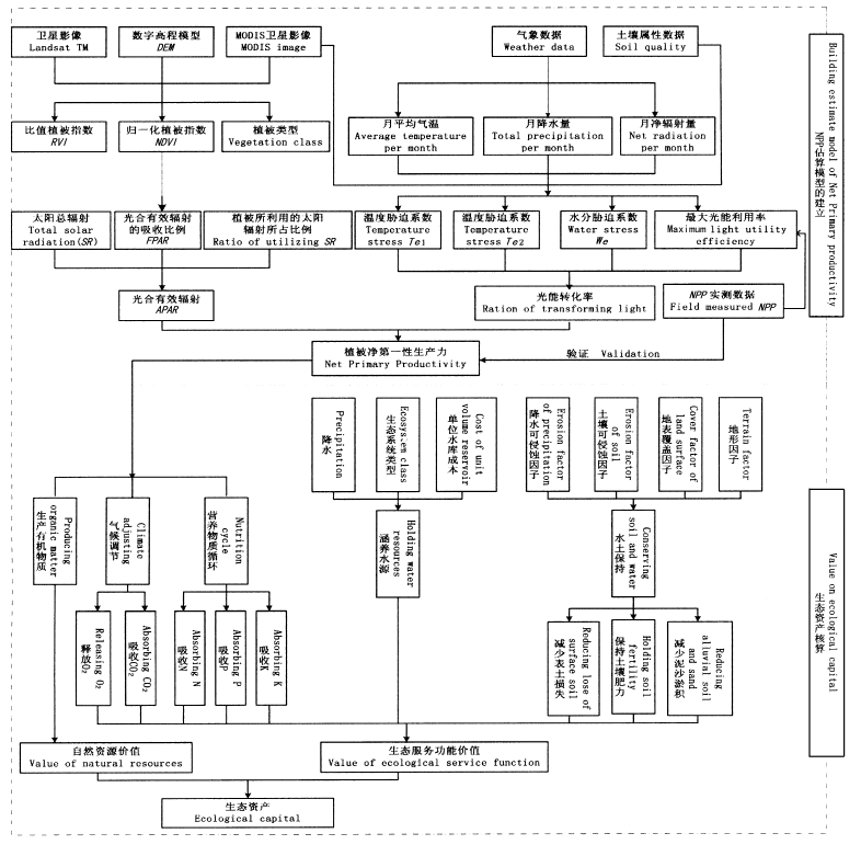
Fig.1 The calculating system of ecological capital based on remotely sensed data
| 项目 Item | 林地 Woodland | 灌丛 Shrub land | 草地 Grassland | 水田 Paddy field | 旱地 Dry land | 裸地 Bare land | 水域/湿地 Water/Wetland |
|---|---|---|---|---|---|---|---|
| 氮N | 0.004 180 | 0.013 294 | 0.013 289 | 0.013 288 | 0.013 203 | 0.013 273 | 0.004 204 |
| 磷P | 0.000 890 | 0.000 092 | 0.000 093 | 0.000 090 | 0.000 087 | 0.000 091 | 0.000 901 |
| 钾K | 0.001 810 | 0.008 904 | 0.008 908 | 0.008 915 | 0.008 874 | 0.008 909 | 0.001 802 |
Table 2 Assigned rate of N、P、K of the ecosystems (g·g-1)
| 项目 Item | 林地 Woodland | 灌丛 Shrub land | 草地 Grassland | 水田 Paddy field | 旱地 Dry land | 裸地 Bare land | 水域/湿地 Water/Wetland |
|---|---|---|---|---|---|---|---|
| 氮N | 0.004 180 | 0.013 294 | 0.013 289 | 0.013 288 | 0.013 203 | 0.013 273 | 0.004 204 |
| 磷P | 0.000 890 | 0.000 092 | 0.000 093 | 0.000 090 | 0.000 087 | 0.000 091 | 0.000 901 |
| 钾K | 0.001 810 | 0.008 904 | 0.008 908 | 0.008 915 | 0.008 874 | 0.008 909 | 0.001 802 |
| 地区 Region | 年份 Year | 草地 Grassland | 灌丛 Shrub land | 裸地 Bare land | 旱地 Dry field | 水田 Paddy field | 水域/湿地 Water/Wetland | 林地 Woodland |
|---|---|---|---|---|---|---|---|---|
| 吴兴 Wuxing | 2001 | 4 952.79 | 17 565.42 | 22 269.38 | 990.80 | 20 335.34 | 6 237.54 | 13 648.74 |
| 2002 | 4 873.65 | 17 960.28 | 22 727.22 | 979.22 | 20 098.95 | 6 247.29 | 13 113.40 | |
| 2003 | 4 923.84 | 18 155.42 | 23 373.14 | 1 317.83 | 21 588.58 | 3 602.05 | 13 039.15 | |
| 2004 | 4 629.29 | 18 220.35 | 23 551.84 | 1 288.87 | 21 722.22 | 3 632.90 | 12 954.52 | |
| 南浔 Nanxun | 2001 | 12 716.42 | 32.56 | 14 749.10 | 1 224.23 | 34 795.04 | 6 300.88 | 781.78 |
| 2002 | 12 519.10 | 43.66 | 15 015.62 | 1 112.12 | 34 653.78 | 6 518.66 | 737.07 | |
| 2003 | 12 752.94 | 67.16 | 15 598.44 | 1 154.89 | 36 093.09 | 4 488.79 | 444.68 | |
| 2004 | 12 554.63 | 58.60 | 15 609.23 | 1 282.26 | 35 783.66 | 5 016.26 | 295.36 | |
| 安吉 Anji | 2001 | 6 394.90 | 43 284.16 | 11 820.60 | 2 629.89 | 18 981.35 | 3 216.26 | 102 272.84 |
| 2002 | 6 152.74 | 43 939.59 | 13 651.15 | 2 733.06 | 20 721.07 | 3 211.02 | 98 191.37 | |
| 2003 | 6 189.10 | 44 012.51 | 18 574.41 | 2 769.79 | 21 141.48 | 2 703.05 | 93 209.67 | |
| 2004 | 6 148.93 | 46 602.97 | 19 260.91 | 2 787.44 | 20 333.09 | 2 729.62 | 90 737.04 | |
| 德清 Deqing | 2001 | 1 364.79 | 12 997.16 | 17 388.21 | 2 126.63 | 19 365.75 | 10 686.36 | 29 671.10 |
| 2002 | 1 408.51 | 13 699.42 | 17 610.40 | 2 358.11 | 19 957.52 | 10 697.55 | 27 868.49 | |
| 2003 | 1 217.59 | 13 779.34 | 19 707.15 | 2 155.00 | 20 780.32 | 11 508.60 | 24 451.99 | |
| 2004 | 1 134.96 | 14 186.26 | 19 607.65 | 2 139.71 | 20 453.01 | 11 842.23 | 24 236.18 | |
| 长兴 Changxing | 2001 | 6 924.70 | 27 991.56 | 28 486.30 | 4 424.79 | 37 435.48 | 3 093.88 | 34 643.29 |
| 2002 | 6 753.45 | 28 892.15 | 29 994.50 | 4 491.07 | 38 100.22 | 3 128.95 | 31 639.67 | |
| 2003 | 6 413.92 | 30 226.34 | 30 117.03 | 4 659.87 | 38 633.37 | 1 983.02 | 30 966.46 | |
| 2004 | 6 798.74 | 30 361.07 | 30 466.65 | 4 740.41 | 39 052.20 | 1 909.71 | 29 671.23 | |
| 湖州 Huzhou | 2001 | 32 353.60 | 101 870.86 | 94 713.59 | 11 396.34 | 130 912.95 | 29 534.92 | 181 017.74 |
| 2002 | 31 707.45 | 104 535.09 | 98 998.89 | 11 673.57 | 133 531.53 | 29 803.47 | 171 550.00 | |
| 2003 | 314 97.39 | 106 240.76 | 107 370.16 | 12 057.38 | 138 236.84 | 24 285.51 | 162 111.95 | |
| 2004 | 31 266.54 | 109 429.25 | 108 496.29 | 12 238.70 | 137 344.17 | 25 130.72 | 157 894.33 |
Table 3 Land use/land cover of the counties (or districts) in Houzhou from 2001 to 2004 (hm2)
| 地区 Region | 年份 Year | 草地 Grassland | 灌丛 Shrub land | 裸地 Bare land | 旱地 Dry field | 水田 Paddy field | 水域/湿地 Water/Wetland | 林地 Woodland |
|---|---|---|---|---|---|---|---|---|
| 吴兴 Wuxing | 2001 | 4 952.79 | 17 565.42 | 22 269.38 | 990.80 | 20 335.34 | 6 237.54 | 13 648.74 |
| 2002 | 4 873.65 | 17 960.28 | 22 727.22 | 979.22 | 20 098.95 | 6 247.29 | 13 113.40 | |
| 2003 | 4 923.84 | 18 155.42 | 23 373.14 | 1 317.83 | 21 588.58 | 3 602.05 | 13 039.15 | |
| 2004 | 4 629.29 | 18 220.35 | 23 551.84 | 1 288.87 | 21 722.22 | 3 632.90 | 12 954.52 | |
| 南浔 Nanxun | 2001 | 12 716.42 | 32.56 | 14 749.10 | 1 224.23 | 34 795.04 | 6 300.88 | 781.78 |
| 2002 | 12 519.10 | 43.66 | 15 015.62 | 1 112.12 | 34 653.78 | 6 518.66 | 737.07 | |
| 2003 | 12 752.94 | 67.16 | 15 598.44 | 1 154.89 | 36 093.09 | 4 488.79 | 444.68 | |
| 2004 | 12 554.63 | 58.60 | 15 609.23 | 1 282.26 | 35 783.66 | 5 016.26 | 295.36 | |
| 安吉 Anji | 2001 | 6 394.90 | 43 284.16 | 11 820.60 | 2 629.89 | 18 981.35 | 3 216.26 | 102 272.84 |
| 2002 | 6 152.74 | 43 939.59 | 13 651.15 | 2 733.06 | 20 721.07 | 3 211.02 | 98 191.37 | |
| 2003 | 6 189.10 | 44 012.51 | 18 574.41 | 2 769.79 | 21 141.48 | 2 703.05 | 93 209.67 | |
| 2004 | 6 148.93 | 46 602.97 | 19 260.91 | 2 787.44 | 20 333.09 | 2 729.62 | 90 737.04 | |
| 德清 Deqing | 2001 | 1 364.79 | 12 997.16 | 17 388.21 | 2 126.63 | 19 365.75 | 10 686.36 | 29 671.10 |
| 2002 | 1 408.51 | 13 699.42 | 17 610.40 | 2 358.11 | 19 957.52 | 10 697.55 | 27 868.49 | |
| 2003 | 1 217.59 | 13 779.34 | 19 707.15 | 2 155.00 | 20 780.32 | 11 508.60 | 24 451.99 | |
| 2004 | 1 134.96 | 14 186.26 | 19 607.65 | 2 139.71 | 20 453.01 | 11 842.23 | 24 236.18 | |
| 长兴 Changxing | 2001 | 6 924.70 | 27 991.56 | 28 486.30 | 4 424.79 | 37 435.48 | 3 093.88 | 34 643.29 |
| 2002 | 6 753.45 | 28 892.15 | 29 994.50 | 4 491.07 | 38 100.22 | 3 128.95 | 31 639.67 | |
| 2003 | 6 413.92 | 30 226.34 | 30 117.03 | 4 659.87 | 38 633.37 | 1 983.02 | 30 966.46 | |
| 2004 | 6 798.74 | 30 361.07 | 30 466.65 | 4 740.41 | 39 052.20 | 1 909.71 | 29 671.23 | |
| 湖州 Huzhou | 2001 | 32 353.60 | 101 870.86 | 94 713.59 | 11 396.34 | 130 912.95 | 29 534.92 | 181 017.74 |
| 2002 | 31 707.45 | 104 535.09 | 98 998.89 | 11 673.57 | 133 531.53 | 29 803.47 | 171 550.00 | |
| 2003 | 314 97.39 | 106 240.76 | 107 370.16 | 12 057.38 | 138 236.84 | 24 285.51 | 162 111.95 | |
| 2004 | 31 266.54 | 109 429.25 | 108 496.29 | 12 238.70 | 137 344.17 | 25 130.72 | 157 894.33 |
| 地区 Region | 年份 Year | 草地 Grassland | 灌丛 Shrub land | 裸地 Bare land | 旱地 Dry field | 水田 Paddy field | 林地 Woodland | 水域/湿地 Water/Wetland | 生态资产合计 Total |
|---|---|---|---|---|---|---|---|---|---|
| 吴兴 Wuxing | 2001 | 13 392.08 | 121 942.24 | 9 737.50 | 1 492.37 | 51 973.78 | 106 903.16 | 2 893.53 | 308 334.66 |
| 2002 | 13 801.49 | 136 974.12 | 11 333.70 | 1 755.59 | 62 699.09 | 118 931.82 | 3 264.88 | 348 760.69 | |
| 2003 | 8 490.24 | 92 785.83 | 8 723.36 | 2 280.74 | 53 204.97 | 83 310.13 | 1 823.51 | 250 618.78 | |
| 2004 | 8 968.55 | 96 928.87 | 9 905.51 | 2 407.48 | 57 638.57 | 86 863.11 | 2 014.44 | 264 726.53 | |
| 南浔 Nanxun | 2001 | 22 287.38 | 1 779.63 | 4 627.17 | 1 248.08 | 87 334.51 | 6 098.63 | 2 944.33 | 126 319.73 |
| 2002 | 24 086.29 | 1 891.77 | 5 695.31 | 1 098.67 | 104 820.06 | 6 436.39 | 3 430.72 | 147 459.21 | |
| 2003 | 18 221.01 | 1 829.80 | 3 962.98 | 1 006.61 | 79 864.74 | 5 960.67 | 2 104.74 | 112 950.55 | |
| 2004 | 19 073.51 | 1 727.60 | 4 765.74 | 1 173.93 | 85 313.80 | 5 229.36 | 2 504.19 | 119 788.13 | |
| 安吉 Anji | 2001 | 32 702.31 | 233 125.80 | 9 943.81 | 5 597.03 | 44 080.22 | 599 742.83 | 1 646.73 | 926 838.73 |
| 2002 | 34 587.26 | 265 964.67 | 11 038.69 | 6 295.09 | 54 445.27 | 605 889.66 | 1 673.23 | 979 893.87 | |
| 2003 | 36 746.3 | 225 176.95 | 12 685.57 | 5 118.47 | 59 284.66 | 514 036.74 | 1 297.60 | 854 346.29 | |
| 2004 | 35 903.78 | 284 679.55 | 13 283.01 | 5 605.98 | 83 222.31 | 485 148.88 | 1 487.49 | 909 331.00 | |
| 德清 Deqing | 2001 | 7 220.92 | 48 216.02 | 7 317.85 | 2 821.07 | 55 003.80 | 181 665.13 | 5 271.08 | 307 515.87 |
| 2002 | 7 795.51 | 55 423.45 | 8 271.69 | 3 245.15 | 68 402.07 | 166 162.41 | 5 737.31 | 315 037.59 | |
| 2003 | 7 585.52 | 40 396.60 | 6 765.36 | 2 349.53 | 48 820.47 | 132 703.02 | 4 795.12 | 243 415.62 | |
| 2004 | 7 379.04 | 56 271.08 | 7 679.69 | 2 704.76 | 51 004.28 | 134 524.29 | 5 396.35 | 264 959.49 | |
| 长兴 Changxing | 2001 | 22 765.85 | 93 765.46 | 14 204.54 | 6 762.81 | 107 638.63 | 201 338.65 | 1 540.26 | 448 016.20 |
| 2002 | 24 299.11 | 106 363.25 | 15 735.22 | 6 521.03 | 115 663.84 | 182 049.30 | 1 631.98 | 452 263.73 | |
| 2003 | 16 755.70 | 97 513.27 | 13 335.86 | 8 277.54 | 103 967.86 | 141 438.28 | 1 040.26 | 382 328.77 | |
| 2004 | 19 774.69 | 92 369.74 | 18 043.34 | 8 073.79 | 90 180.24 | 140 961.93 | 1 083.50 | 370 487.23 | |
| 湖州 Huzhou | 2001 | 98 368.55 | 498 829.15 | 45 830.86 | 17 921.37 | 346 030.94 | 1 095 748.40 | 14 295.93 | 2 117 025.20 |
| 2002 | 104 569.66 | 566 617.26 | 52 074.61 | 18 915.53 | 406 030.33 | 1 079 469.58 | 15 738.12 | 2 243 415.09 | |
| 2003 | 87 798.77 | 457 702.45 | 45 473.13 | 19 032.88 | 345 142.69 | 877 448.82 | 11 061.23 | 1 843 659.97 | |
| 2004 | 91 099.57 | 531 976.84 | 53 677.30 | 19 965.95 | 367 359.20 | 852 727.58 | 12 485.97 | 1 929 292.41 |
Table 4 Ecological capital (104 RMB) of countries (or districts) in Huzhou from 2001 to 2004
| 地区 Region | 年份 Year | 草地 Grassland | 灌丛 Shrub land | 裸地 Bare land | 旱地 Dry field | 水田 Paddy field | 林地 Woodland | 水域/湿地 Water/Wetland | 生态资产合计 Total |
|---|---|---|---|---|---|---|---|---|---|
| 吴兴 Wuxing | 2001 | 13 392.08 | 121 942.24 | 9 737.50 | 1 492.37 | 51 973.78 | 106 903.16 | 2 893.53 | 308 334.66 |
| 2002 | 13 801.49 | 136 974.12 | 11 333.70 | 1 755.59 | 62 699.09 | 118 931.82 | 3 264.88 | 348 760.69 | |
| 2003 | 8 490.24 | 92 785.83 | 8 723.36 | 2 280.74 | 53 204.97 | 83 310.13 | 1 823.51 | 250 618.78 | |
| 2004 | 8 968.55 | 96 928.87 | 9 905.51 | 2 407.48 | 57 638.57 | 86 863.11 | 2 014.44 | 264 726.53 | |
| 南浔 Nanxun | 2001 | 22 287.38 | 1 779.63 | 4 627.17 | 1 248.08 | 87 334.51 | 6 098.63 | 2 944.33 | 126 319.73 |
| 2002 | 24 086.29 | 1 891.77 | 5 695.31 | 1 098.67 | 104 820.06 | 6 436.39 | 3 430.72 | 147 459.21 | |
| 2003 | 18 221.01 | 1 829.80 | 3 962.98 | 1 006.61 | 79 864.74 | 5 960.67 | 2 104.74 | 112 950.55 | |
| 2004 | 19 073.51 | 1 727.60 | 4 765.74 | 1 173.93 | 85 313.80 | 5 229.36 | 2 504.19 | 119 788.13 | |
| 安吉 Anji | 2001 | 32 702.31 | 233 125.80 | 9 943.81 | 5 597.03 | 44 080.22 | 599 742.83 | 1 646.73 | 926 838.73 |
| 2002 | 34 587.26 | 265 964.67 | 11 038.69 | 6 295.09 | 54 445.27 | 605 889.66 | 1 673.23 | 979 893.87 | |
| 2003 | 36 746.3 | 225 176.95 | 12 685.57 | 5 118.47 | 59 284.66 | 514 036.74 | 1 297.60 | 854 346.29 | |
| 2004 | 35 903.78 | 284 679.55 | 13 283.01 | 5 605.98 | 83 222.31 | 485 148.88 | 1 487.49 | 909 331.00 | |
| 德清 Deqing | 2001 | 7 220.92 | 48 216.02 | 7 317.85 | 2 821.07 | 55 003.80 | 181 665.13 | 5 271.08 | 307 515.87 |
| 2002 | 7 795.51 | 55 423.45 | 8 271.69 | 3 245.15 | 68 402.07 | 166 162.41 | 5 737.31 | 315 037.59 | |
| 2003 | 7 585.52 | 40 396.60 | 6 765.36 | 2 349.53 | 48 820.47 | 132 703.02 | 4 795.12 | 243 415.62 | |
| 2004 | 7 379.04 | 56 271.08 | 7 679.69 | 2 704.76 | 51 004.28 | 134 524.29 | 5 396.35 | 264 959.49 | |
| 长兴 Changxing | 2001 | 22 765.85 | 93 765.46 | 14 204.54 | 6 762.81 | 107 638.63 | 201 338.65 | 1 540.26 | 448 016.20 |
| 2002 | 24 299.11 | 106 363.25 | 15 735.22 | 6 521.03 | 115 663.84 | 182 049.30 | 1 631.98 | 452 263.73 | |
| 2003 | 16 755.70 | 97 513.27 | 13 335.86 | 8 277.54 | 103 967.86 | 141 438.28 | 1 040.26 | 382 328.77 | |
| 2004 | 19 774.69 | 92 369.74 | 18 043.34 | 8 073.79 | 90 180.24 | 140 961.93 | 1 083.50 | 370 487.23 | |
| 湖州 Huzhou | 2001 | 98 368.55 | 498 829.15 | 45 830.86 | 17 921.37 | 346 030.94 | 1 095 748.40 | 14 295.93 | 2 117 025.20 |
| 2002 | 104 569.66 | 566 617.26 | 52 074.61 | 18 915.53 | 406 030.33 | 1 079 469.58 | 15 738.12 | 2 243 415.09 | |
| 2003 | 87 798.77 | 457 702.45 | 45 473.13 | 19 032.88 | 345 142.69 | 877 448.82 | 11 061.23 | 1 843 659.97 | |
| 2004 | 91 099.57 | 531 976.84 | 53 677.30 | 19 965.95 | 367 359.20 | 852 727.58 | 12 485.97 | 1 929 292.41 |
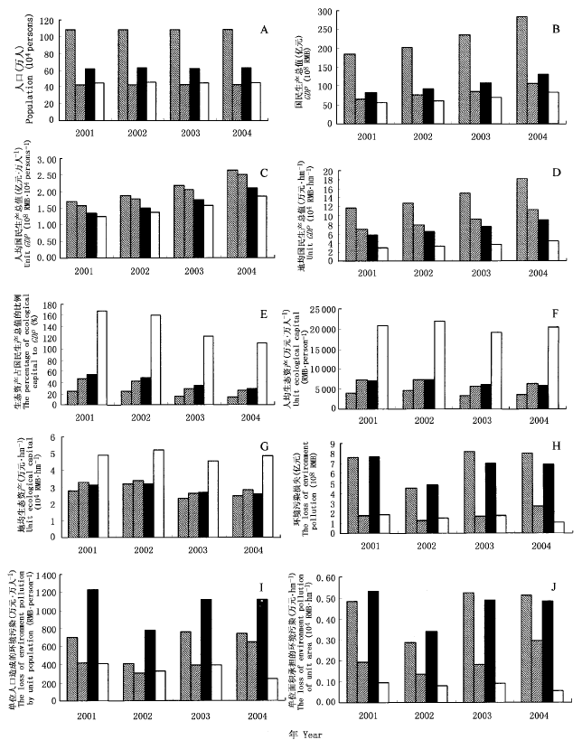
Fig.2 Natural, social and economical indexes analysis of counties and districts in Huzhou
| [1] | Bjorklund J, Limburg K, Rydberg T (1999). Impact of production intensity on the ability of the agricultural landscape to generate ecosystem services: an example from Sweden. Ecological Economics, 29,269-291. |
| [2] | Bolund P, Hunhammar S (1999). Ecosystem services in urban areas. Ecological Economics, 29,293-301. |
| [3] | Chen ZX (陈仲新), Zhang XS (张新时) (2000). The benefit value of Chinese ecosystem. Chinese Science Bulletin (科学通报), 45,17-22. (in Chinese with English abstract) |
| [4] | Costanza R, d'Arge R, de Groot R, Farber S, Grasso M, Hannon B, Limburg K, Naeem S, O'Neill RV, Paruelo J, Raskin RG, Sutton P, van den Belt M (1997). The value of the world's ecosystem services and natural capital. Nature, 387,253-260. |
| [5] |
Daily GC, Søderqvist T, Aniyar S, Arrow K, Dasgupta P, Ehrlich PR, Folke C, Jansson AM, Jansson BO, Kautsky N, Levin S, Lubchenco J, M⁉ler KG, Simpson P, Starrett D, Tilman D, Walker B (2000). The value of nature and nature of value. Science, 289,395-396.
DOI URL PMID |
| [6] | David P (1997). Ecological accountancy. Science, 387,253-260. |
| [7] | Dixon J, Bakkes J, Hanilton K translated by Zhang KM (张坤民)) (1998). Expanding the Measure of Wealth: Indicators of Environmental Sustainable Development, (扩展衡量财富的手段——环境可持续发展指标). China Environmental Science Press, Beijing. (in Chinese) |
| [8] |
Field CB, Behrenfeld MJ, Randerson JT, Falkowski P (1998). Primary production of the biosphere: integrating terrestrial and oceanic components. Science, 281,237-240.
URL PMID |
| [9] | Holmund CM, Hammer M (1999). Ecosystem services generated by fish population. Ecological Economics, 29,253-268. |
| [10] | Huang XW (黄兴文), Chen BM (陈百明) (1999). The theory and application about the regionalization of Chinese ecological assets. Acta Ecologica Sinica (生态学报), 19,602-606. (in Chinese with English abstract) |
| [11] | Ouyang ZY (欧阳志云), Wang XK (王效科), Miao H (苗鸿) (1999). A primary study on Chinese terrestrial ecosystem services and their ecological-economic values. Acta Ecologica Sinica (生态学报), 19,607-612. (in Chinese with English abstract) |
| [12] | Pan YZ (潘耀忠), Shi PJ (史培军), Zhu WQ (朱文泉), Gu XH (顾晓鹤), Fan YD (范一大), Li J (李京) (2004). Quantitative measured ecological capital on Chinese terrestrial ecosystem based on remote sensed data. Science in China Ser. D (中国科学D辑), 34,375-384. (in Chinese with English abstract) |
| [13] | Pearce D, Atkinson G (1993). Capital theory and the measure of sustainable development: an indicator of weak sustainability. Ecological Economics, 8,103-108. |
| [14] | Potschin MB, Haines-Young RH (2003). Improving the quality of environmental assessments using the concept of natural capital: a case study from southern Germany. Landscape and Urban Planning, 63,93-108. |
| [15] | Potter CS, Randerson JT, Field CB, Matson PA, Vitousek PM, Mooney HA, Klooster SA (1993). Terrestrial ecosystem production: a process model based on global on global satellite and surface data. Global Biochemical Cycles, 7,811-841. |
| [16] | Shi PJ (史培军), Pan YZ (潘耀忠), Chen YH (陈云浩), Li XB (李晓兵), Li J (李京), Jing GF (景贵飞), Xian ZK (鲜祖康), Zhang SY (张淑英) (2002). Technical system of ecological capital integrated measurement using multi-scale remotely sensed data. Advance in Earth Sciences (地球科学进展), 17,169-173. (in Chinese with English abstract) |
| [17] | Vitousek P, Ehrlich PR, Ehrlich AH, Matson P (1986). Human appropriation of the products of photosynthesis. BioScience, 36,368-373. |
| [18] | Wackernagel M, Lewan L, Hansson CB (1999). Evaluating the use of natural capital with the ecological footprint: application in Sweden and subregions. AMBIO, 28,604-612. |
| [1] | HAO Qing, HUANG Chang. A review of forest aboveground biomass estimation based on remote sensing data [J]. Chin J Plant Ecol, 2023, 47(10): 1356-1374. |
| [2] | ZHANG Yi, CHENG Jie, SU Ji-Shuai, CHENG Ji-Min. Diversity-productivity relationship of plant communities in typical grassland during the long- term grazing exclusion succession [J]. Chin J Plant Ecol, 2022, 46(2): 176-187. |
| [3] | CONG Nan, ZHANG Yang-Jian, ZHU Jun-Tao. Temperature sensitivity of vegetation phenology in spring in mid- to high-latitude regions of Northern Hemisphere during the recent three decades [J]. Chin J Plant Ecol, 2022, 46(2): 125-135. |
| [4] | ZANG Yong-Xin, MA Jian-Ying, ZHOU Xiao-Bing, TAO Ye, YIN Ben-Feng, Shayaguli JIGEER, ZHANG Yuan-Ming. Effects of extreme drought and extreme precipitation on aboveground productivity of ephemeral plants across different slope positions along sand dunes [J]. Chin J Plant Ecol, 2022, 46(12): 1537-1550. |
| [5] | JIANG Yan, CHEN Xing-Fang, YANG Xu-Jie. Changes of aquatic plants in Donghu Lake of Wuhan based 1990-2020 Landsat images [J]. Chin J Plant Ecol, 2022, 46(12): 1551-1561. |
| [6] | TIAN Jia-Yu, WANG Bin, ZHANG Zhi-Ming, LIN Lu-Xiang. Application of spectral diversity in plant diversity monitoring and assessment [J]. Chin J Plant Ecol, 2022, 46(10): 1129-1150. |
| [7] | YAN Zheng-Bing, LIU Shu-Wen, WU Jin. Hyperspectral remote sensing of plant functional traits: monitoring techniques and future advances [J]. Chin J Plant Ecol, 2022, 46(10): 1151-1166. |
| [8] | JI Yu-He, ZHOU Guang-Sheng, WANG Shu-Dong, WANG Li-Xia, ZHOU Meng-Zi. Evolution characteristics and its driving forces analysis of vegetation ecological quality in Qinling Mountains region from 2000 to 2019 [J]. Chin J Plant Ecol, 2021, 45(6): 617-625. |
| [9] | CHEN Zhe, WANG Hao, WANG Jin-Zhou, SHI Hui-Jin, LIU Hui-Ying, HE Jin-Sheng. Estimation on seasonal dynamics of alpine grassland aboveground biomass using phenology camera-derived NDVI [J]. Chin J Plant Ecol, 2021, 45(5): 487-495. |
| [10] | WANG Yi-Dan, LI Liang, LIU Qi-Jing, MA Ze-Qing. Lifespan and morphological traits of absorptive fine roots across six typical tree species in subtropical China [J]. Chin J Plant Ecol, 2021, 45(4): 383-393. |
| [11] | GAMADAERJI , YANG Ze, TAN Xing-Ru, WANG Shan-Shan, LI Wei-Jing, YOU Cui-Hai, WANG Yan-Bing, ZHANG Bing-Wei, REN Ting-Ting, CHEN Shi-Ping. Effect of altered litter input and nitrogen addition on ecosystem aboveground primary productivity and plant functional group composition in a semiarid grassland [J]. Chin J Plant Ecol, 2020, 44(8): 791-806. |
| [12] | GUO Qing-Hua, HU Tian-Yu, MA Qin, XU Ke-Xin, YANG Qiu-Li, SUN Qian-Hui, LI Yu-Mei, SU Yan-Jun. Advances for the new remote sensing technology in ecosystem ecology research [J]. Chin J Plant Ecol, 2020, 44(4): 418-435. |
| [13] | SHU Shu-Miao, ZHU Wan-Ze, RAN Fei, SUN Shou-Qin, ZHANG Yuan-Yuan. Season dynamics of carbon use efficiency and its influencing factors in the old-growth Abies fabri forest in Gongga Mountain, western Sichuan, China [J]. Chin J Plant Ecol, 2020, 44(11): 1127-1137. |
| [14] | WANG Yu-Bing,SUN Yi-Han,DING Wei,ZHANG En-Tao,LI Wen-Huai,CHI Yong-Gang,ZHENG Shu-Xia. Effects and pathways of long-term nitrogen addition on plant diversity and primary productivity in a typical steppe [J]. Chin J Plant Ecol, 2020, 44(1): 22-32. |
| [15] | ZHANG Fu-Guang, ZENG Biao, YANG Tai-Bao. Spatiotemporal distribution changes in alpine desert belt in Qilian Mountains under climate changes in past 30 years [J]. Chin J Plant Ecol, 2019, 43(4): 305-319. |
| Viewed | ||||||
|
Full text |
|
|||||
|
Abstract |
|
|||||
Copyright © 2022 Chinese Journal of Plant Ecology
Tel: 010-62836134, 62836138, E-mail: apes@ibcas.ac.cn, cjpe@ibcas.ac.cn