
Chin J Plant Ecol ›› 2007, Vol. 31 ›› Issue (6): 1063-1072.DOI: 10.17521/cjpe.2007.0134
• Research Articles • Previous Articles Next Articles
LIU Hai-Jiang( ), CHENG Wei-Ming, LONG En
Received:2006-05-10
Accepted:2006-08-21
Online:2007-05-10
Published:2007-11-30
LIU Hai-Jiang, CHENG Wei-Ming, LONG En. LANDSCAPE CHANGES IN A DEGRADED SANDY LAND ECOSYSTEM—A CASE STUDY IN THE OTINDAG SANDY LAND, INNER MONGOLIA, CHINA[J]. Chin J Plant Ecol, 2007, 31(6): 1063-1072.
Add to citation manager EndNote|Ris|BibTeX
URL: https://www.plant-ecology.com/EN/10.17521/cjpe.2007.0134
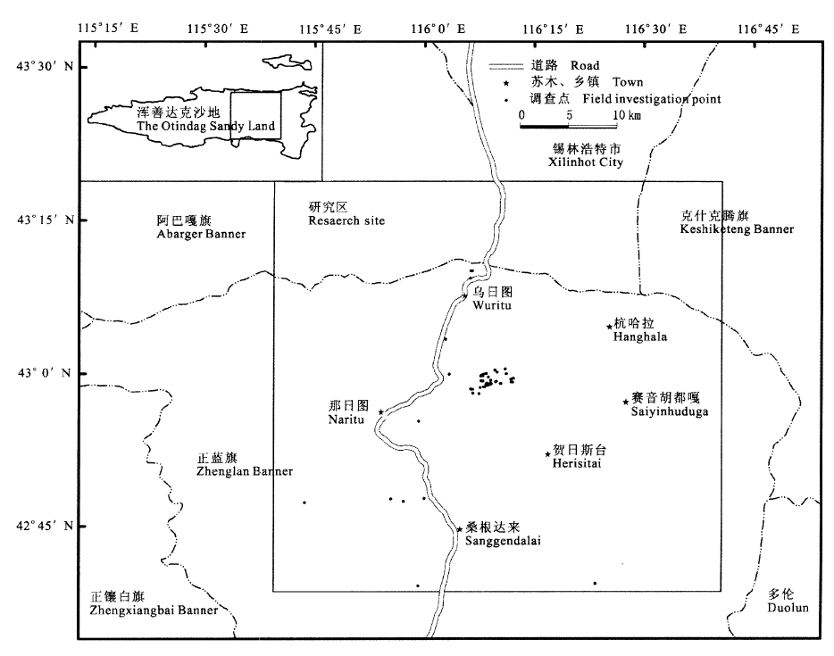
Fig.1 The location of study area
| 景观类型 Landscape types | 特征 Feature | ||||||
|---|---|---|---|---|---|---|---|
| 水域 Water | 沙地中分布的大大小小的湖泊(淖尔) Different sizes of lakes are distributed in the sandy land | ||||||
| 灌木林 Shrub | 分布在丘间洼地上或河流两岸、湖泊周围,建群种为小红柳 This community is dominated by shrub Salix microstachya var. bordensis and mainly distributed on riverside, lakeshore and depression in interdune plain | ||||||
| 草原 Grassland | 分布于丘间的平沙地上,群落物种为典型草原常见种,以糙隐子草、冷蒿、苔草、冰草为优势种,局部地下水位高的地方,生长以西伯利亚剪股颖、鹅绒委陵菜、金戴戴为优势种的草甸 This community is distributed in interdune plain, and the dominate species include Cleistogenes squarrosa, Artemisia frigida, Agropyron cristatum and Carex sp., which are the common species occurring in typical grassland community. Another community occurs in the area with high water level, which is just like meadow. Preponderant species are Agrostis sibirica, Potentilla anserina and Halerpestes ruthenica | ||||||
| 固定沙地 Fixed sandy land | 包括缓起伏沙地和沙丘,都有茂密的植被覆盖,有些地方地表有结皮 This landscape includes two landforms. One is gently waved sandland and the other is sand dunes. All of them are covered by flourishing vegetation. Soil crust generates in some places | ||||||
| 半固定沙地 Semi-fixed sandy land | 包括缓起伏沙地和沙丘,物种主要为沙生及一年生物种,群落结构尚未形成,基质不稳定 This landscape includes two landforms. One is gently waved sandland and the other is sand dune. The species are mainly psammophyte and annual plants, and community structure does not exist | ||||||
| 流动沙地 Mobile sandy dune | 植被稀疏,基质裸露,物种主要为一年生先锋物种 This landscape is characterized by very sparse annual pioneer plants and mobile sand substrate | ||||||
Table 1 Features of landscape types at study area
| 景观类型 Landscape types | 特征 Feature | ||||||
|---|---|---|---|---|---|---|---|
| 水域 Water | 沙地中分布的大大小小的湖泊(淖尔) Different sizes of lakes are distributed in the sandy land | ||||||
| 灌木林 Shrub | 分布在丘间洼地上或河流两岸、湖泊周围,建群种为小红柳 This community is dominated by shrub Salix microstachya var. bordensis and mainly distributed on riverside, lakeshore and depression in interdune plain | ||||||
| 草原 Grassland | 分布于丘间的平沙地上,群落物种为典型草原常见种,以糙隐子草、冷蒿、苔草、冰草为优势种,局部地下水位高的地方,生长以西伯利亚剪股颖、鹅绒委陵菜、金戴戴为优势种的草甸 This community is distributed in interdune plain, and the dominate species include Cleistogenes squarrosa, Artemisia frigida, Agropyron cristatum and Carex sp., which are the common species occurring in typical grassland community. Another community occurs in the area with high water level, which is just like meadow. Preponderant species are Agrostis sibirica, Potentilla anserina and Halerpestes ruthenica | ||||||
| 固定沙地 Fixed sandy land | 包括缓起伏沙地和沙丘,都有茂密的植被覆盖,有些地方地表有结皮 This landscape includes two landforms. One is gently waved sandland and the other is sand dunes. All of them are covered by flourishing vegetation. Soil crust generates in some places | ||||||
| 半固定沙地 Semi-fixed sandy land | 包括缓起伏沙地和沙丘,物种主要为沙生及一年生物种,群落结构尚未形成,基质不稳定 This landscape includes two landforms. One is gently waved sandland and the other is sand dune. The species are mainly psammophyte and annual plants, and community structure does not exist | ||||||
| 流动沙地 Mobile sandy dune | 植被稀疏,基质裸露,物种主要为一年生先锋物种 This landscape is characterized by very sparse annual pioneer plants and mobile sand substrate | ||||||
| 景观类型 Landscape types | 时间 Time | 斑块数 No. of patches | 平均斑块面积 Mean patch area (km2) | 标准偏差 SD | 总面积 Total area (km2) | 百分比 Percentage (%) |
|---|---|---|---|---|---|---|
| 水域 Water | 1987 2000 | 19 22 | 2.04 1.76 | 2.98 2.05 | 38.74 38.66 | 0.77 0.77 |
| 灌木林 Shrub | 1987 2000 | 99 178 | 1.42 1.28 | 2.21 3.16 | 140.37 228.57 | 2.80 4.56 |
| 草原 Grassland | 1987 2000 | 491 435 | 3.59 3.70 | 14.50 22.46 | 1 762.40 1 611.48 | 35.16 32.14 |
| 固定沙地 Fixed sandy land | 1987 2000 | 124 263 | 10.60 3.52 | 52.15 12.17 | 1 314.68 926.70 | 26.23 18.48 |
| 半固定沙地 Semi-fixed sandy land | 1987 2000 | 149 370 | 9.86 3.32 | 37.42 14.93 | 1 468.97 1 227.76 | 29.30 24.49 |
| 流动沙地 Mobile sandy dune | 1987 2000 | 101 81 | 2.85 12.10 | 4.94 45.58 | 287.69 980.10 | 5.74 19.55 |
Table 2 Landscape pattern at study area in 1987 and 2000
| 景观类型 Landscape types | 时间 Time | 斑块数 No. of patches | 平均斑块面积 Mean patch area (km2) | 标准偏差 SD | 总面积 Total area (km2) | 百分比 Percentage (%) |
|---|---|---|---|---|---|---|
| 水域 Water | 1987 2000 | 19 22 | 2.04 1.76 | 2.98 2.05 | 38.74 38.66 | 0.77 0.77 |
| 灌木林 Shrub | 1987 2000 | 99 178 | 1.42 1.28 | 2.21 3.16 | 140.37 228.57 | 2.80 4.56 |
| 草原 Grassland | 1987 2000 | 491 435 | 3.59 3.70 | 14.50 22.46 | 1 762.40 1 611.48 | 35.16 32.14 |
| 固定沙地 Fixed sandy land | 1987 2000 | 124 263 | 10.60 3.52 | 52.15 12.17 | 1 314.68 926.70 | 26.23 18.48 |
| 半固定沙地 Semi-fixed sandy land | 1987 2000 | 149 370 | 9.86 3.32 | 37.42 14.93 | 1 468.97 1 227.76 | 29.30 24.49 |
| 流动沙地 Mobile sandy dune | 1987 2000 | 101 81 | 2.85 12.10 | 4.94 45.58 | 287.69 980.10 | 5.74 19.55 |
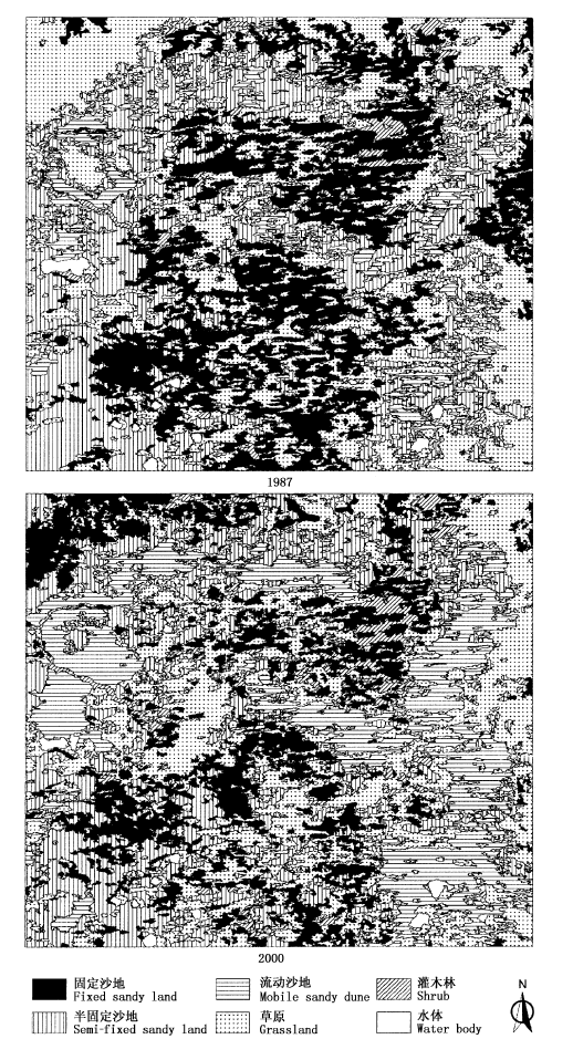
Fig.2 Supervised classification maps of landscape types at study area in 1987 and 2000
| 1987 | 2000 | |||||
|---|---|---|---|---|---|---|
| 水域 Water | 灌木林 Shrub | 草原 Grassland | 固定沙地 Fixed sandy land | 半固定沙地 Semi-fixed sandy land | 流动沙地 Mobile sandy dune | |
| 水域 Water | 30.88 79.50% | 0.60 1.55% | 3.41 8.77% | 0.14 0.37% | 0.21 0.55% | 3.60 9.26% |
| 灌木林 Shrub | 3.90 2.78% | 113.11 80.68% | 14.09 10.05% | 6.45 4.60% | 0.99 0.71% | 1.66 1.18% |
| 草原 Grassland | 1.40 0.08% | 42.66 2.42% | 989.23 56.04% | 282.45 16.00% | 260.61 14.76% | 199.95 10.70% |
| 固定沙地 Fixed sandy land | 0.42 0.03% | 63.32 4.81% | 362.14 27.50% | 553.37 42.02% | 325.26 24.70% | 12.26 0.93% |
| 半固定沙地 Semi-fixed sandy land | 1.25 0.09% | 7.13 0.48% | 231.90 15.76% | 84.95 5.77% | 623.61 42.38% | 522.49 35.51% |
| 流动沙地 Mobile sandy dune | 0.87 0.30% | 1.45 0.50% | 13.48 4.68% | 0.84 0.29% | 19.42 6.75% | 251.75 87.47% |
Table 3 The transition area (km2) and percentage among landscape types at study area from 1987 to 2000
| 1987 | 2000 | |||||
|---|---|---|---|---|---|---|
| 水域 Water | 灌木林 Shrub | 草原 Grassland | 固定沙地 Fixed sandy land | 半固定沙地 Semi-fixed sandy land | 流动沙地 Mobile sandy dune | |
| 水域 Water | 30.88 79.50% | 0.60 1.55% | 3.41 8.77% | 0.14 0.37% | 0.21 0.55% | 3.60 9.26% |
| 灌木林 Shrub | 3.90 2.78% | 113.11 80.68% | 14.09 10.05% | 6.45 4.60% | 0.99 0.71% | 1.66 1.18% |
| 草原 Grassland | 1.40 0.08% | 42.66 2.42% | 989.23 56.04% | 282.45 16.00% | 260.61 14.76% | 199.95 10.70% |
| 固定沙地 Fixed sandy land | 0.42 0.03% | 63.32 4.81% | 362.14 27.50% | 553.37 42.02% | 325.26 24.70% | 12.26 0.93% |
| 半固定沙地 Semi-fixed sandy land | 1.25 0.09% | 7.13 0.48% | 231.90 15.76% | 84.95 5.77% | 623.61 42.38% | 522.49 35.51% |
| 流动沙地 Mobile sandy dune | 0.87 0.30% | 1.45 0.50% | 13.48 4.68% | 0.84 0.29% | 19.42 6.75% | 251.75 87.47% |
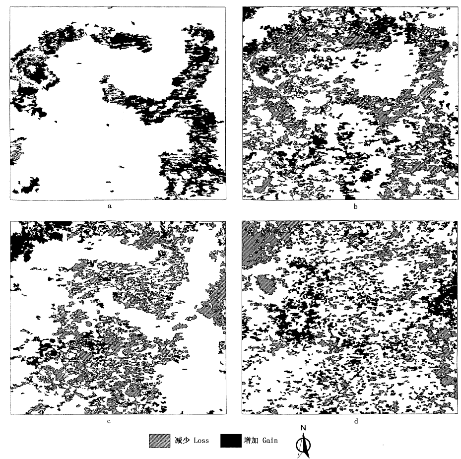
Fig.3 Spatial changes of four dominant landscape types from 1987 to 2000 at study area a, b, c and d represent active sandy land, semi-fixed sandy land, fixed sandy land and grassland, respectively
| [1] | Bock M, Rossner G, Wissen M, Remm K, Langanke T, Lang S, Klug H, Blaschke T, Vršcaj B (2005). Spatial indicators for nature conservation from European to local scale. Ecological Indicators, 5,322-338. |
| [2] | Dale VH, Beyeler SC (2001). Challenges in the development and use of ecological indicators. Ecological Indicators, 1,3-10. |
| [3] | Ding GD (丁国栋), Cai JY (蔡京艳), Wang X (王贤), Dong Z (董智), Fan JY (范建友), Chen PP (陈平平) (2004). Causes, process and countermeasures of desertification in Hunshandake Sandland: taking Zhenglan Banner, Inner Mongolia as an example. Journal of Beijing Forestry University (北京林业大学学报), 26(4),15-19. (in Chinese with English abstract) |
| [4] | Fan JY (范建友), Ding GD (丁国栋), Guan BY (关博源), Wang X (王贤), Li SY (李素艳), Yang TT (杨婷婷) (2005). Monitoring remote sensing of dynamic change of vegetation coverage in Zhenglan Banner. Science of Soil and Water Conservation (中国水土保持科学), 3(4),54-59. (in Chinese with English abstract) |
| [5] | Fu BJ, Hu CH, Chen LD, Honnay O, Gulinck H (2006). Evaluating change in agricultural landscape pattern between 1980 and 2000 in the Loess hilly region of Ansai County, China. Agriculture Ecosystems & Environment, 114,387-396. |
| [6] |
Griffith RK, Stehman SV, Loveland TR (2003). Landscape trends in mid-Atlantic and southeastern U.S. ecoregions. Environmental Management, 32,572-588.
DOI URL PMID |
| [7] | Guo K (郭柯), Dong XJ (董学军), Liu ZM (刘志茂) (2000). Characteristics of soil moisture content on sand dunes in Mu Us Sandy grassland: why Artemisia ordosica declines on old fixed sand dunes. Acta Phytoecologica Sinica (植物生态学报), 24,275-279. (in Chinese with English abstract) |
| [8] | Guo K (郭柯), Liu HJ (刘海江) (2004). A comparative researches in the development of seedlings in four habitats in the Hunshandak Sandland, Inner Mongolia, China. Acta Ecologica Sinica (生态学报), 24,2024-2028. (in Chinese with English abstract) |
| [9] | He Q (何晴), Lü DR (吕达仁) (2003). Monitoring vegetation cover change in east Hunshandake Sandy Land with Landsat TM and ETM + and its possible causes. Remote Sensing Technology and Application (遥感技术与应用), 18,353-359. (in Chinese with English abstract) |
| [10] | Hugenholtz CH, Wolfe SA (2005). Recent stabilization of active sand dunes on the Canadian prairies and relation to recent climate variations. Geomorphology, 68,121-147. |
| [11] | Li QF (李青丰), Hu CY (胡春元), Wang MJ (王明玖) (2001). Analysis on the causes of eco-environmental deterioration in Hunshandake Sandy Land region and countermeasures. Journal of Arid Land Resources and Environment (干旱区资源与环境), 15,9-16. (in Chinese with English abstract) |
| [12] | Liu SL (刘树林), Wang T (王涛) (2004). Primary study on sandy desertification in Otindag Sandy Land and its surrounding regions. Journal of Soil and Water Conservation (水土保持学报), 18,99-103. (in Chinese with English abstract) |
| [13] | Liu MZ (刘美珍), Jiang GM (蒋高明), Yu SL (于顺利), Li YG (李永庚), Gao LM (高雷明), Niu SL (牛书丽), Jiang CD (姜闯道), Peng Y (彭羽) (2004). Dynamics of plant community traite during an 18-year natural restoration in the degraded sandy grassland of Hunshandak Sandland. Acta Ecologica Sinica (生态学报), 24,1734-1740. (in Chinese with English abstract) |
| [14] | Olsen LM, Dale VH, Foster T (2007). Landscape pattern as indicators of ecological change at Fort Benning, Georgia, USA. Landscape and Urban Planning, 79,137-149. |
| [15] | Peterseil J, Wrbka T, Plutzar C, Schmitzberger I, Kiss A, Szerencsits E, Reiter K, Schneider W, Suppan F, Beissmann H (2004). Evaluating the ecological sustainability of Austrian agricultural landscapes—the SINUS approach. Land Use Policy, 21,307-320. |
| [16] | Potschin M, Haines-Young R (2006). “Rio+10”, sustainability science and landscape ecology. Landscape and Urban Planning, 75,162-174. |
| [17] | Turner MG (2005). Landscape ecology: what is the state of the science? Annual Review of Ecology Evolution and Systematics, 36,319-344. |
| [18] | United Scientific Exploration Team of Inner Mongolia and Ningxia, Chinese Academy of Sciences (中国科学院内蒙古宁夏综合科考队) (1985). Vegetation of Inner Mongolia (内蒙古植被). Science Press, Beijing, 766. (in Chinese) |
| [19] | Wang X (王贤), Ding GD (丁国栋), Cai JY (蔡京艳), Chen PP (陈平平), Fan JY (范建友), Li SY (李素艳) (2004). Causes and comprehensive control measures of desertification in Hunshandake Sand Land. Journal of Soil and Water Conservation (水土保持学报), 18,147-150. (in Chinese with English abstract) |
| [20] | Wang GL (王革丽), Lü D R (吕达仁), You L (尤莉) (2002). Analyses of climatic characteristics on Hunshandake dust storm. Climatic and Environmental Research (气候与环境研究), 7,433-439. (in Chinese with English abstract) |
| [21] | Wrbka T, Erb KH, Schulz NB, Peterseil J, Hahn C, Haberl H (2004). Linking pattern and process in cultural landscapes. An empirical study based on spatially explicit indicators. Land Use Policy, 21,289-306. |
| [22] | Wu JG (邬建国) (2000). Landscape Ecology: Pattern, Process, Scale and Hierarchy (景观生态学——格局、过程、尺度与等级). Higher Education Press, Beijing, 11. (in Chinese) |
| [23] | Wu JG (邬建国) (2004). The key research topics in landscape ecology. Acta Ecologica Sinica (生态学报), 24,2074-2076. (in Chinese with English abstract) |
| [24] | Wu JG (2006). Landscape ecology, cross-disciplinarity, and sustainability science. Landscape Ecology, 21,1-4. |
| [25] | Wu XP (吴晓莆), Tang ZY (唐志尧), Cui HT (崔海亭), Fang JY (方精云) (2006). Land cover dynamics of different topographic conditions in Beijing. Journal of Plant Ecology (Chinese Version) (formerly Acta Phytoecologica Sinica) (植物生态学报), 30,239-251. (in Chinese with English abstract) |
| [26] | Yang SK (杨淑宽), Chen JS (陈静生), Guo XM (郭蓄民) (1962). Exploration of Xiaotenggeli Sandy Land. In: Sand Controlling Team of Chinese Academy of Sciences (中国科学院治沙队) ed. Sand Controlling (治沙研究). Science Press, Beijing, 3,144-151. (in Chinese) |
| [27] | Yang SK (杨淑宽) (1964). The vegetation of Xiaotenggeli Sandy Land in Inner Mongolia. Geographical Research (地理研究), 8,32-46. (in Chinese) |
| [28] | Zhao SQ (赵松乔), Yang LP (杨利普), Yang QY (杨勤业) (1990). The Arid Region of China (中国的干旱区). Science Press, Beijing, 38. (in Chinese) |
| [29] | Zheng YR, Xue ZX, Robert C, Jiang LH, Shimizu H (2006). Did climate drive ecosystem change and induce desertification in Otindag Sandy Land, China over the past 40 years? Journal of Arid Environments, 64,523-541. |
| [30] | Zhu ZD (朱震达), Chen GT (陈广庭) (1994). Sandy Desertification in China (中国土地沙质荒漠化). Science Press, Beijing, 20. (in Chinese) |
| [31] | Zhu HY (朱会义), Li XB (李秀彬) (2003). Discussion on the index method of regional land use change. Acta Geographica Sinica (地理学报), 58,643-650. (in Chinese with English abstract) |
| [1] | HAO Qing, HUANG Chang. A review of forest aboveground biomass estimation based on remote sensing data [J]. Chin J Plant Ecol, 2023, 47(10): 1356-1374. |
| [2] | SUN Cai-Li, QIU Mo-Sheng, HUANG Chao-Xiang, WANG Yi-Wei. Characteristics of soil extracellular enzyme activities and their stoichiometry during rocky desertification in southwestern Guizhou, China [J]. Chin J Plant Ecol, 2022, 46(7): 834-845. |
| [3] | CONG Nan, ZHANG Yang-Jian, ZHU Jun-Tao. Temperature sensitivity of vegetation phenology in spring in mid- to high-latitude regions of Northern Hemisphere during the recent three decades [J]. Chin J Plant Ecol, 2022, 46(2): 125-135. |
| [4] | JIANG Yan, CHEN Xing-Fang, YANG Xu-Jie. Changes of aquatic plants in Donghu Lake of Wuhan based 1990-2020 Landsat images [J]. Chin J Plant Ecol, 2022, 46(12): 1551-1561. |
| [5] | TIAN Jia-Yu, WANG Bin, ZHANG Zhi-Ming, LIN Lu-Xiang. Application of spectral diversity in plant diversity monitoring and assessment [J]. Chin J Plant Ecol, 2022, 46(10): 1129-1150. |
| [6] | YAN Zheng-Bing, LIU Shu-Wen, WU Jin. Hyperspectral remote sensing of plant functional traits: monitoring techniques and future advances [J]. Chin J Plant Ecol, 2022, 46(10): 1151-1166. |
| [7] | Nan DONG, Ming-Ming TANG, Wen-Qian CUI, Meng-Yao YUE, Jie LIU, Yu-Jie HUANG. Growth of chestnut and tea seedlings under different root partitioning patterns [J]. Chin J Plant Ecol, 2022, 46(1): 62-73. |
| [8] | CHEN Zhe, WANG Hao, WANG Jin-Zhou, SHI Hui-Jin, LIU Hui-Ying, HE Jin-Sheng. Estimation on seasonal dynamics of alpine grassland aboveground biomass using phenology camera-derived NDVI [J]. Chin J Plant Ecol, 2021, 45(5): 487-495. |
| [9] | XUE Peng-Fei, LI Wen-Long, ZHU Gao-Feng, ZHOU Hua-Kun, LIU Chen-Li, YAN He-Piao. Changes in the pattern of an alpine wetland landscape in Maqu County in the first meander of the Yellow River [J]. Chin J Plant Ecol, 2021, 45(5): 467-475. |
| [10] | HU Qi-Juan, SHENG Mao-Yin, YIN Jie, BAI Yi-Xin. Stoichiometric characteristics of fine roots and rhizosphere soil of Broussonetia papyrifera adapted to the karst rocky desertification environment in southwest China [J]. Chin J Plant Ecol, 2020, 44(9): 962-972. |
| [11] | GUO Qing-Hua, HU Tian-Yu, MA Qin, XU Ke-Xin, YANG Qiu-Li, SUN Qian-Hui, LI Yu-Mei, SU Yan-Jun. Advances for the new remote sensing technology in ecosystem ecology research [J]. Chin J Plant Ecol, 2020, 44(4): 418-435. |
| [12] | ZHANG Fu-Guang, ZENG Biao, YANG Tai-Bao. Spatiotemporal distribution changes in alpine desert belt in Qilian Mountains under climate changes in past 30 years [J]. Chin J Plant Ecol, 2019, 43(4): 305-319. |
| [13] | NING Yao, LEI Jin-Rui, SONG Xi-Qiang, HAN Shu-Mei, ZHONG Yun-Fang. Modeling the potential suitable habitat of Impatiens hainanensis, a limestone-endemic plant [J]. Chin J Plant Ecol, 2018, 42(9): 946-954. |
| [14] | YU Xiao-Ya, LI Yu-Hui, YANG Guang-Rong. Fruit types and seed dispersal modes of plants in different communities in Shilin Geopark, Yunnan, China [J]. Chin J Plant Ecol, 2018, 42(6): 663-671. |
| [15] | ZHANG Feng,ZHOU Guang-Sheng. Research progress on monitoring vegetation water content by using hyperspectral remote sensing [J]. Chin J Plan Ecolo, 2018, 42(5): 517-525. |
| Viewed | ||||||
|
Full text |
|
|||||
|
Abstract |
|
|||||
Copyright © 2022 Chinese Journal of Plant Ecology
Tel: 010-62836134, 62836138, E-mail: apes@ibcas.ac.cn, cjpe@ibcas.ac.cn