
Chin J Plan Ecolo ›› 2015, Vol. 39 ›› Issue (11): 1053-1061.DOI: 10.17521/cjpe.2015.0102
Special Issue: 遥感生态学
• Orginal Article • Previous Articles Next Articles
ZHU Xu-Chao1,2, YUAN Guo-Fu1,*( ), SHAO Ming-An1,4, YI Xiao-Bo3, DU Tao1,2
Online:2015-11-01
Published:2015-12-02
Contact:
Guo-Fu YUAN
About author:# Co-first authors
ZHU Xu-Chao, YUAN Guo-Fu, SHAO Ming-An, YI Xiao-Bo, DU Tao. Spatial pattern of riparian vegetation in desert of the lower Tarim River basin[J]. Chin J Plan Ecolo, 2015, 39(11): 1053-1061.
Add to citation manager EndNote|Ris|BibTeX
URL: https://www.plant-ecology.com/EN/10.17521/cjpe.2015.0102

Fig. 1 Location of the lower Tarim River basin. The three dashed line boxes shows the scope of the selected three remote sensing images.
| 类别 Classification | 柽柳灌丛 Tamarix thickets | 胡杨疏林 Populus euphratica woodlands | 沙地 Sand lands | 农田 Farmlands | 水体 Water bodies | 芦苇草地 Phragmites australis grasslands | 总和 Total | 制图精度(%) Mapping accuracy |
|---|---|---|---|---|---|---|---|---|
| 柽柳灌丛 Tamarix thickets | 9 982 | 3 121 | 1 375 | 102 | 48 | 160 | 14 788 | 67.5 |
| 胡杨疏林 Populus euphratica woodlands | 6 403 | 23 758 | 413 | 30 | 91 | 523 | 31 218 | 76.1 |
| 沙地 Sand lands | 1 424 | 228 | 38 380 | 0 | 21 | 1 | 40 054 | 95.8 |
| 农田 Farmlands | 8 | 13 | 0 | 9 881 | 1 | 33 | 9 936 | 99.4 |
| 水体 Water bodies | 0 | 0 | 0 | 0 | 58 371 | 14 | 58 385 | 99.9 |
| 芦苇草地 Phragmites australis grasslands | 569 | 1 658 | 23 | 858 | 2 110 | 15 964 | 21 182 | 75.4 |
| 综合 Total | 18 386 | 28 778 | 40 191 | 10 871 | 60 642 | 16 695 | 175 563 | — |
| 用户精度 User accuracy (%) | 54.3 | 82.6 | 95.5 | 90.9 | 96.3 | 95.6 | — | — |
| 总精度 Total accuracy = 89.0%; Kappa系数 Kappa coefficient = 0.86 | ||||||||
Table 1 Error matrix of wrongly and omissively classified pixels of classification types
| 类别 Classification | 柽柳灌丛 Tamarix thickets | 胡杨疏林 Populus euphratica woodlands | 沙地 Sand lands | 农田 Farmlands | 水体 Water bodies | 芦苇草地 Phragmites australis grasslands | 总和 Total | 制图精度(%) Mapping accuracy |
|---|---|---|---|---|---|---|---|---|
| 柽柳灌丛 Tamarix thickets | 9 982 | 3 121 | 1 375 | 102 | 48 | 160 | 14 788 | 67.5 |
| 胡杨疏林 Populus euphratica woodlands | 6 403 | 23 758 | 413 | 30 | 91 | 523 | 31 218 | 76.1 |
| 沙地 Sand lands | 1 424 | 228 | 38 380 | 0 | 21 | 1 | 40 054 | 95.8 |
| 农田 Farmlands | 8 | 13 | 0 | 9 881 | 1 | 33 | 9 936 | 99.4 |
| 水体 Water bodies | 0 | 0 | 0 | 0 | 58 371 | 14 | 58 385 | 99.9 |
| 芦苇草地 Phragmites australis grasslands | 569 | 1 658 | 23 | 858 | 2 110 | 15 964 | 21 182 | 75.4 |
| 综合 Total | 18 386 | 28 778 | 40 191 | 10 871 | 60 642 | 16 695 | 175 563 | — |
| 用户精度 User accuracy (%) | 54.3 | 82.6 | 95.5 | 90.9 | 96.3 | 95.6 | — | — |
| 总精度 Total accuracy = 89.0%; Kappa系数 Kappa coefficient = 0.86 | ||||||||
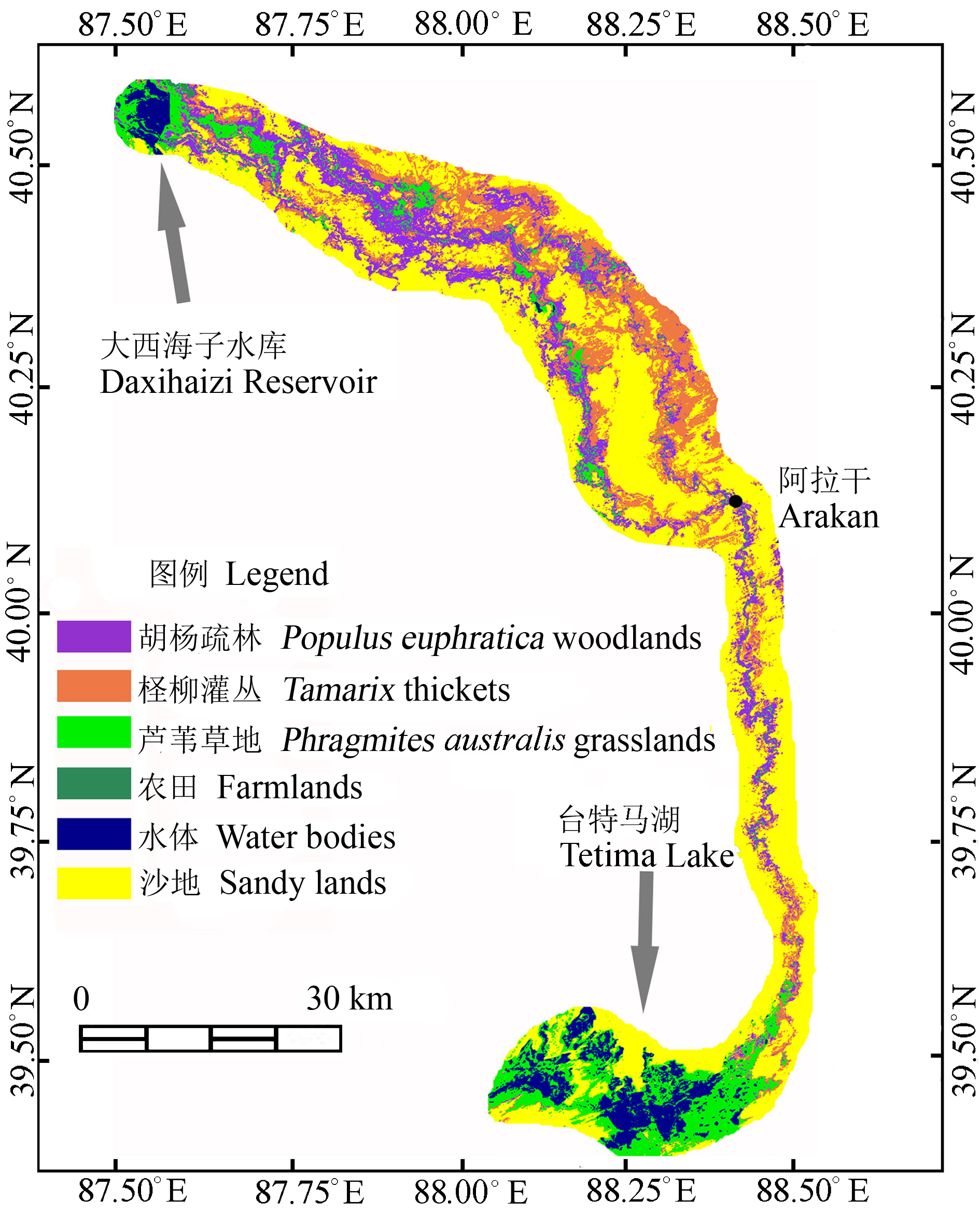
Fig. 2 Result of landscape classification in the study area.
| 类别 Classification | 像元数 Number of pixels | 面积 Area (km2) |
|---|---|---|
| 柽柳灌丛 Tamarix thickets | 450 293 | 405.3 |
| 胡杨疏林 Populus euphratica woodlands | 373 813 | 336.4 |
| 芦苇草地 Phragmites australis grasslands | 316 968 | 285.3 |
| 水体 Water bodies | 159 345 | 143.4 |
Table 2 Areas of Tamarix thickets, Populus euphratica woodlands, Phragmites australis grasslands and water bodies in the study area derived by remote sensing interpretation
| 类别 Classification | 像元数 Number of pixels | 面积 Area (km2) |
|---|---|---|
| 柽柳灌丛 Tamarix thickets | 450 293 | 405.3 |
| 胡杨疏林 Populus euphratica woodlands | 373 813 | 336.4 |
| 芦苇草地 Phragmites australis grasslands | 316 968 | 285.3 |
| 水体 Water bodies | 159 345 | 143.4 |
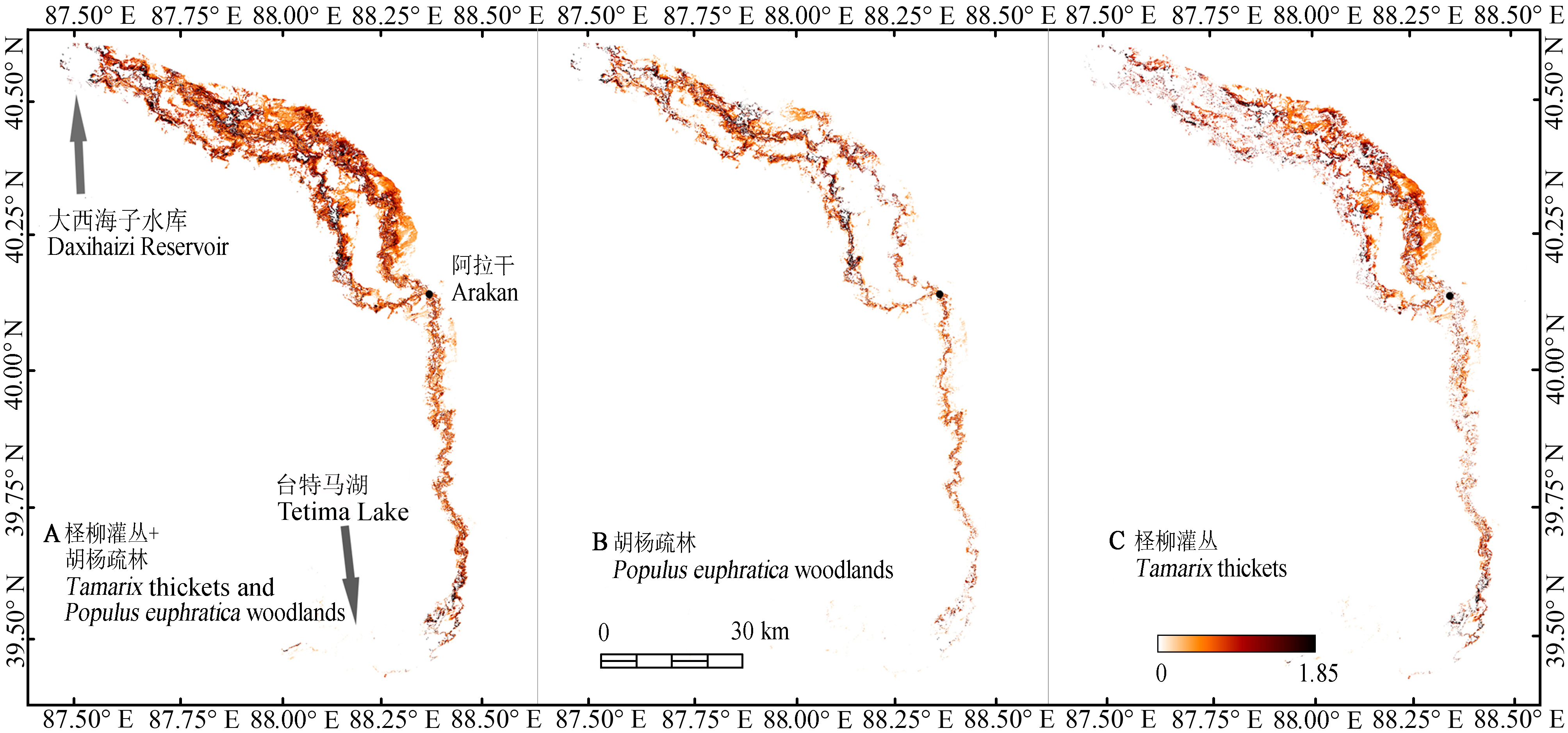
Fig. 3 Spatial distribution of leaf area indices of the Populus euphratica woodlands and the Tamarix thickets in the lower Tarim River basin.
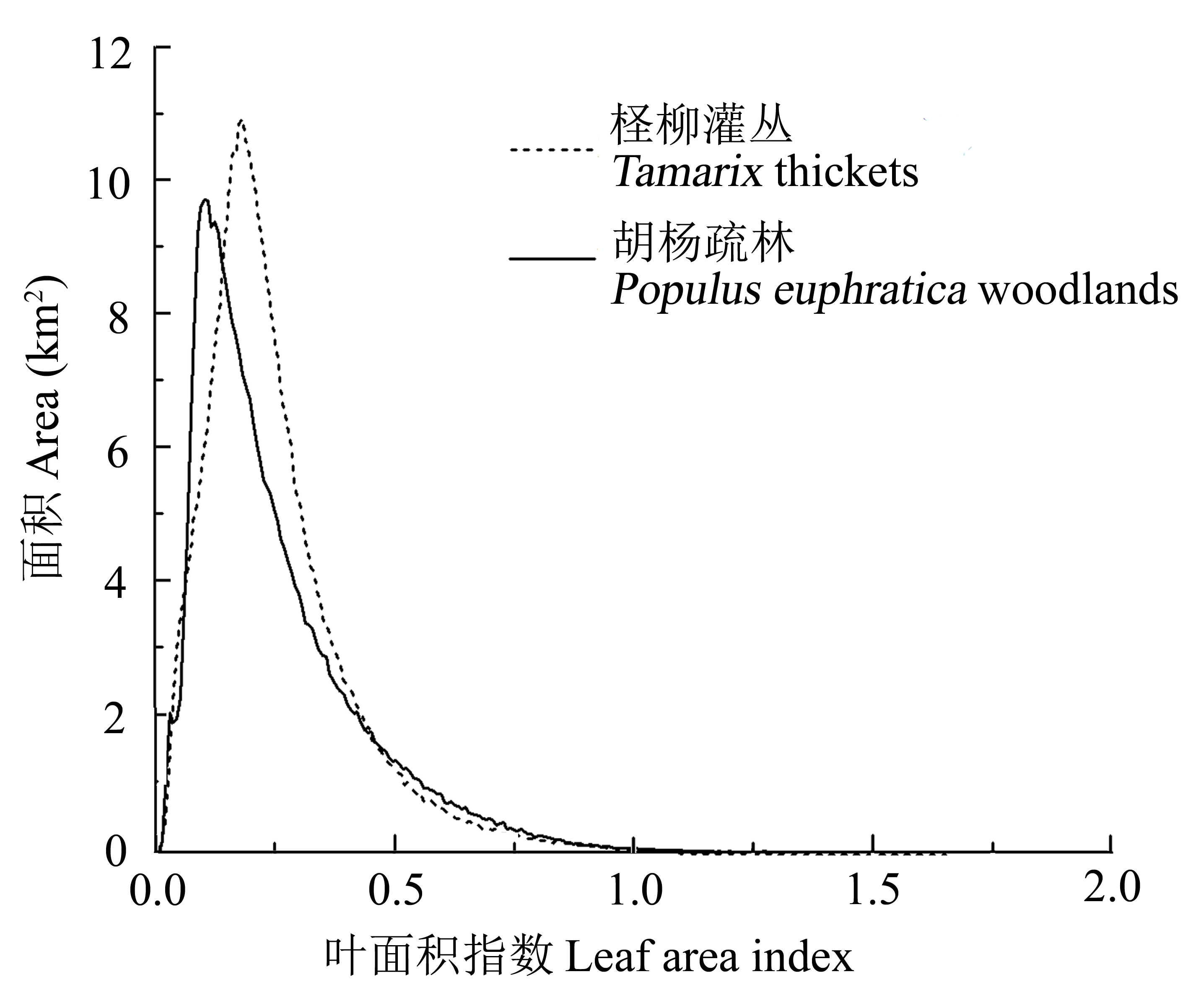
Fig. 4 Areas of different leaf area indices of Tamarix thickets and Populus euphratica woodlands in the study area.
| 像元数 Number of pixels | 最小值 Minimum | 最大值 Maximum | 众数 Mode | 平均值 Average | 标准偏差 Standard deviation | 变异系数 Coefficient of variation (%) | |
|---|---|---|---|---|---|---|---|
| 柽柳灌丛 Tamarix thickets | 450 293 | 0.005 | 1.653 | 0.182 | 0.253 | 0.158 | 62.3 |
| 胡杨疏林 Populus euphratica woodlands | 373 813 | 0.007 | 1.849 | 0.102 | 0.252 | 0.178 | 70.5 |
Table 3 Statistical characteristics of leaf area indices of Tamarix thickets and Populus euphratica woodlands
| 像元数 Number of pixels | 最小值 Minimum | 最大值 Maximum | 众数 Mode | 平均值 Average | 标准偏差 Standard deviation | 变异系数 Coefficient of variation (%) | |
|---|---|---|---|---|---|---|---|
| 柽柳灌丛 Tamarix thickets | 450 293 | 0.005 | 1.653 | 0.182 | 0.253 | 0.158 | 62.3 |
| 胡杨疏林 Populus euphratica woodlands | 373 813 | 0.007 | 1.849 | 0.102 | 0.252 | 0.178 | 70.5 |
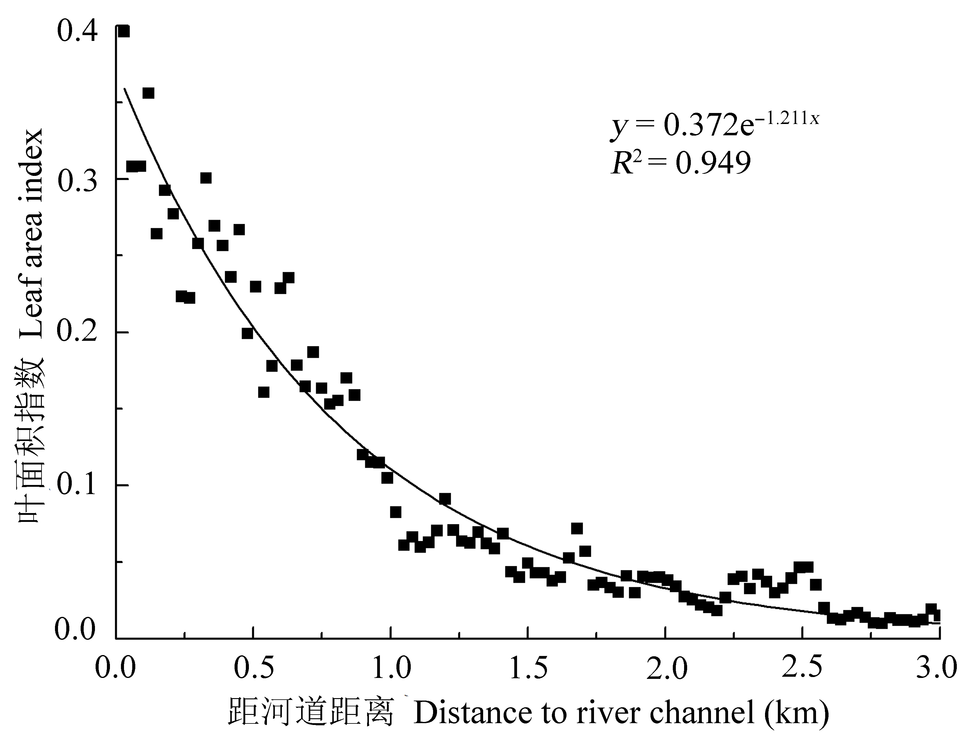
Fig. 5 Relationship between leaf area indices and distances away from the river channel.
| 1 | Bai Y, Xu HL, Tu WX, Ling HB, Fu JY, Wang XY (2013). Population structure and spatial distribution of the Populus euphratica in the mainstream of the Tarim River.Acta Botanica Boreali-Occidentalia Sinica, 33, 1216-1223. |
| (in Chinese with English abstract) [白元, 徐海量, 涂文霞, 凌红波, 傅荩仪, 王希义 (2013). 塔里木河干流胡杨种群结构与分布格局研究. 西北植物学报, 33, 1216-1223.] | |
| 2 | Deng CZ, Zhang XM, Li L, Wu JX, Zhu JT, Liu GJ, Lü CY (2010). Community characteristics and population structure of Populus euphratica Oliv in lower reaches of Tarim River.Journal of Desert Research, 30, 589-595. |
| (in Chinese with English abstract) [邓潮洲, 张希明, 李利, 吴俊侠, 朱军涛, 刘国军, 吕朝燕 (2010). 塔里木河下游胡杨群落特征及种群结构分析. 中国沙漠, 30, 589-595.] | |
| 3 | Guli J, Chen X, Ma ZG, Chang C (2009). Classification of sparse desert riparian forest in extreme arid region.Journal of Desert Research, 29, 1153-1161. |
| (in Chinese with English abstract) [古丽·加帕尔, 陈曦, 马忠国, 常存 (2009). 极端干旱区荒漠稀疏河岸林遥感分类研究. 中国沙漠, 29, 1153-1161.] | |
| 4 | Huang Y, Bao AM, Wang SF, Wang YQ, Duan YB (2013). Eco-environmental change in the lower Tarim River under the influence of intermittent water transport.Acta Geographica Sinica, 68, 1251-1262. |
| (in Chinese with English abstract) [黄粤, 包安明, 王士飞, 王永琴, 段远彬 (2013). 间歇性输水影响下的2001-2011年塔里木河下游生态环境变化. 地理学报, 68, 1251-1262.] | |
| 5 | Liu HJ, Cheng WM, Long E (2007). Landscape changes in a degraded sandy land ecosystem—A case study in the Otindag Sandy Land, Inner Mongolia, China. Journal of Plant Ecology (Chinese Version), 31, 1063-1072. |
| (in Chinese with English abstract) [刘海江, 程维明, 龙恩 (2007). 受损沙地生态系统景观变化分析——以内蒙古浑善达克沙地为例. 植物生态学报, 31, 1063-1072.] | |
| 6 | Liu XH, Xu HL, Ling HB, Bai Y, Fu JY, Zhao XF (2013). Ecological water requirements in the lower reaches of the Tarim River.Journal of Desert Research, 33, 1198-1205. |
| (in Chinese with English abstract) [刘新华, 徐海量, 凌红波, 白元, 傅荩仪, 赵新风 (2013). 塔里木河下游生态需水估算. 中国沙漠, 33, 1198-1205.] | |
| 7 | Okin GS, de Las Heras MM, Saco PM, Throop HL, Vivoni ER, Parsons AJ, Wainwright J, Peters DPC (2015). Connectivity in dryland landscapes: Shifting concepts of spatial interactions.Frontiers in Ecology and the Environment, 13, 20-27. |
| 8 | Tao H, Gemmer M, Song YD, Jiang T (2008). Ecohydrological responses on water diversion in the lower reaches of the Tarim River, China.Water Resources Research, 44, W08422, doi: 10.1029/2007WR006186. |
| 9 | Xu H, Li Y, Xu GQ, Zou T (2007). Ecophysiological response and morphological adjustment of two Central Asian desert shrubs towards variation in summer precipitation.Plant, Cell & Environment, 30, 399-409. |
| 10 | Xu HQ, Tang F (2013). Analysis of new characteristics of the first Landsat 8 image and their eco-environmental significance.Acta Ecologica Sinica, 33, 3249-3257. |
| (in Chinese with English abstract) [徐涵秋, 唐菲 (2013). 新一代Landsat系列卫星: Landsat 8遥感影像新增特征及其生态环境意义. 生态学报, 33, 3249-3257.] | |
| 11 | Yuan GF, Luo Y, Shao MA, Zhang P, Zhu XC (2015). |
| 12 | Evapotranspiration and its main controlling mechanism over the desert riparian forests in the lower Tarim River Basin.Science China Earth Sciences, 58, 1032-1042. |
| 13 | Yuan GF, Zhang P, Shao MA, Luo Y, Zhu XC (2014). Energy and water exchanges over a riparian Tamarix spp. stand in the lower Tarim River basin under a hyper-arid climate.Agricultural and Forest Meteorology, 194, 144-154. |
| 14 | Zhang HF (2007). The Research on Plant Community Structure and Dominant Species Pattern in the Lower Reaches of Tarim River. Master degree dissertation, Xinjiang Agricultural University, Ürümqi. 52-60. |
| (in Chinese with English abstract). [张绘芳 (2007). 塔里木河下游植物群落结构特征及优势种群格局研究. 硕士学位论文, 新疆农业大学, 乌鲁木齐. 52-60.] | |
| 15 | Zhang HF, Li X, Gao YQ (2012). Population’s pattern analysis based on high-resolution remote sensing images of Quick Bird.Xinjiang Agricultural Sciences, 49, 2029-2034. |
| (in Chinese with English abstract) [张绘芳, 李霞, 高亚琪 (2012). 基于Quick Bird数据的胡杨、柽柳种群格局分析. 新疆农业科学,49, 2029-2034.] | |
| 16 | Zhang HF, Li X, Wang JG, Yang YJ (2007). The structure characteristic of the plant community in the lower reaches of Tarim River.Ecology and Environment, 16, 1219-1224. |
| (in Chinese with English abstract) [张绘芳, 李霞, 王建刚, 杨艳静 (2007). 塔里木河下游植物群落结构特征分析. 生态环境,16, 1219-1224.] | |
| 17 | Zhang X, Liu XC, Xiao JD, Yang ZH (2005). Study on the EOS/MODIS image processing and its application in monitoring the vegetation change in the lower reaches of the Tarim River.Arid Zone Research, 22, 532-536. |
| (in Chinese with English abstract) [张旭, 刘新春, 肖继东, 杨志华 (2005). EOS/MODIS影像处理在塔里木河下游植被监测中的应用. 干旱区研究, 22, 532-536.] | |
| 18 | Zhang YM, Chen YN, Pan BR (2005). Distribution and floristics of desert plant communities in the lower reaches of Tarim River, southern Xinjiang, People’s Republic of China.Journal of Arid Environments, 63, 772-784. |
| 19 | Zhao YS (2003). Principle and Method of Analysis of Remote Sensing Application. Science Press, Beijing. 204-208. |
| (in Chinese) [赵英时 (2003). 遥感应用分析原理与方法. 科学出版社, 北京. 204-208.] | |
| 20 | Zhu JT, Yu JJ, Wang P, Wang ZY (2011). Quantitative classification and analysis of relationships between plant communities and their groundwater environment in the Ejin Desert Oasis of China.Chinese Journal of Plant Ecology, 35, 480-489. |
| (in Chinese with English abstract) [朱军涛, 于静洁, 王平, 王志勇 (2011). 额济纳荒漠绿洲植物群落的数量分类及其与地下水环境的关系分析. 植物生态学报, 35, 480-489.] | |
| 21 | Zhu JT, Yu JJ, Wang P, Yu Q, Eamus D (2013). Distribution patterns of groundwater-dependent vegetation species diversity and their relationship to groundwater attributes in northwestern China.Ecohydrology, 6, 191-200. |
| 22 | Zhu XC, Yuan GF, Yi XB, Du T (2014). Leaf area index inversion of riparian forest in the lower basin of Tarim River based on Landsat 8 OLI images.Arid Land Geography, 37, 1248-1256. |
| (in Chinese with English abstract) [朱绪超, 袁国富, 易小波, 杜涛 (2014). 基于Landsat 8 OLI影像的塔里木河下游河岸林叶面积指数反演. 干旱区地理, 37, 1248-1256.] |
| [1] | ZHAO Chang-Xing, ZHAO Wei-Jun, ZHANG Xing-Lin, LIU Si-Min, MOU Wen-Bo, LIU Jin-Rong. Analyses of intraspecific competition and facilitation of Picea crassifolia in Pailugou Watershed of Qilian Mountains, China [J]. Chin J Plant Ecol, 2022, 46(9): 1027-1037. |
| [2] | ZHENG Zhou-Tao, ZHANG Yang-Jian. Variation in ecosystem water use efficiency and its attribution analysis during 1982-2018 in Qingzang Plateau [J]. Chin J Plant Ecol, 2022, 46(12): 1486-1496. |
| [3] | LIU Bing-Bing, WEI Jian-Xin, HU Tian-Yu, YANG Qiu-Li, LIU Xiao-Qiang, WU Fa-Yun, SU Yan-Jun, GUO Qing-Hua. Validation and uncertainty analysis of satellite remote sensing products for monitoring China’s forest ecosystems—Based on massive UAV LiDAR data [J]. Chin J Plant Ecol, 2022, 46(10): 1305-1316. |
| [4] | LIU Chao, LI Ping, WU Yun-Tao, PAN Sheng-Nan, JIA Zhou, LIU Ling-Li. Estimation of grassland aboveground biomass using digital photograph and canopy structure measurements [J]. Chin J Plant Ecol, 2022, 46(10): 1280-1288. |
| [5] | HUANG Song-Yu, JIA Xin, ZHENG Jia-Jia, YANG Rui-Zhi, MU Yu, YUAN He-Di. Characteristics and influencing factors of Bowen ratio variation in typical terrestrial ecosystems in China [J]. Chin J Plant Ecol, 2021, 45(2): 119-130. |
| [6] | CHEN Shi-Ping, YOU Cui-Hai, HU Zhong-Min, CHEN Zhi, ZHANG Lei-Ming, WANG Qiu-Feng. Eddy covariance technique and its applications in flux observations of terrestrial ecosystems [J]. Chin J Plant Ecol, 2020, 44(4): 291-304. |
| [7] | FENG Si-Yuan, WEI Ya-Nan, WANG Zhen-Juan, YU Xin-Yang. Pedestrian-view urban street vegetation monitoring using Baidu Street View images [J]. Chin J Plant Ecol, 2020, 44(3): 205-213. |
| [8] | TANG Li-Li, YANG Tong, LIU Hong-Yan, KANG Mu-Yi, WANG Ren-Qing, ZHANG Feng, GAO Xian-Ming, YUE Ming, ZHANG Mei, ZHENG Pu-Fan, SHI Fu-Chen. Distribution and species diversity patterns of Vitex negundo var. heterophylla shrublands in North China [J]. Chin J Plant Ecol, 2019, 43(9): 825-833. |
| [9] | YANG Huan-Ying, SONG Jian-Da, ZHOU Tao, JIN Guang-Ze, JIANG Feng, LIU Zhi-Li. Influences of stand, soil and space factors on spatial heterogeneity of leaf area index in a spruce-fir valley forest in Xiao Hinggan Ling, China [J]. Chin J Plant Ecol, 2019, 43(4): 342-351. |
| [10] | Ze-Bin LIU, Yan-Hui WANG, Yu LIU, Ao TIAN, Ya-Rui WANG, Hai-Jun ZUO. Spatiotemporal variation and scale effect of canopy leaf area index of larch plantation on a slope of the semi-humid Liupan Mountains, Ningxia, China [J]. Chin J Plant Ecol, 2017, 41(7): 749-760. |
| [11] | Bo-Liang WEI, Zhi-Liang YUAN, Shuai NIU, Xia LIU, Hong-Ru JIA, Yong-Zhong YE. Effects of tree mortality on the spatial patterns and interspecific associations of plant species in a Quercus aliena var. acuteserrata forest in Baotianman, Henan, China [J]. Chin J Plan Ecolo, 2017, 41(4): 430-438. |
| [12] | GAO Lin, WANG Xiao-Fei, GU Xing-Fa, TIAN Qing-Jiu, JIAO Jun-Nan, WANG Pei-Yan, LI Dan. Exploring the influence of soil types underneath the canopy in winter wheat leaf area index remote estimating [J]. Chin J Plant Ecol, 2017, 41(12): 1273-1288. |
| [13] | Jie-Lin GE, Gao-Ming XIONG, Jia-Xiang LI, Wen-Ting XU, Chang-Ming ZHAO, Zhi-Jun LU, Yue-Lin LI, Zong-Qiang XIE. Litter standing crop of shrubland ecosystems in southern China [J]. Chin J Plant Ecol, 2017, 41(1): 5-13. |
| [14] | Ming ZHOU, Zhi-Li LIU, Guang-Ze JIN. Improving the accuracy of indirect methods in estimating leaf area index using three correction schemes in a Larix gmelinii plantation [J]. Chin J Plant Ecol, 2016, 40(6): 574-584. |
| [15] | LIU Zhi-Li, JIN Guang-Ze, ZHOU Ming. Measuring seasonal dynamics of leaf area index in a mixed conifer-broadleaved forest with direct and indirect methods [J]. Chin J Plant Ecol, 2014, 38(8): 843-856. |
| Viewed | ||||||
|
Full text |
|
|||||
|
Abstract |
|
|||||
Copyright © 2022 Chinese Journal of Plant Ecology
Tel: 010-62836134, 62836138, E-mail: apes@ibcas.ac.cn, cjpe@ibcas.ac.cn