
Chin J Plant Ecol ›› 2009, Vol. 33 ›› Issue (6): 1056-1064.DOI: 10.3773/j.issn.1005-264x.2009.06.005
• Original article • Previous Articles Next Articles
ZHANG Xiao-Ping1,*( ), ZHANG Lu2, LI Rui1, YANG Qin-Ke1
Received:2009-01-08
Online:2009-01-08
Published:2021-04-29
Contact:
ZHANG Xiao-Ping
ZHANG Xiao-Ping, ZHANG Lu, LI Rui, YANG Qin-Ke. DEM-BASED MODELING OF THE IMPACT OF VEGETATION RESTORATION ON ANNUAL STREAMFLOW IN THE LOESS PLATEAU OF CHINA[J]. Chin J Plant Ecol, 2009, 33(6): 1056-1064.
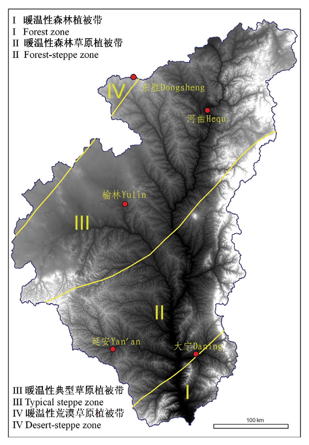
Fig. 1 Division of bio-climate zone for the He- Long region (Wang, 1991) The background is 100 m DEM with elevation from 311 to 2 816 m
| 坡向及方位角(°)*范围 Aspect and its ranging | 坡度 Slope (°) | 坡型 Slope profile | |
|---|---|---|---|
| 地面实际坡度 The actual ground slope | 100 m DEM生成坡度** Slope generated from 100 m DEM | ||
| 东北向Northeast: 23~67 | 25 | 6.99 | 凸型坡 Convex slope (DEM单元格曲率≥0 The curvature of grid equal or greater than 0) 凹型坡 Concave slope (DEM单元格曲率<0 The curvature of grid less than 0) |
| 北向坡North: 338~360; 0~22 | 28 | 11.5 | |
| 西北向Northwest: 293~337 | 30 | 13.5 | |
| 东向East: 68~112 | 32 | 15.5 | |
| 西向West: 248~292 | 35 | 18.2 | |
| 东南向Southeast: 113~157 | 38 | 20.5 | |
| 南向South: 158~202 | 40 | 21.5 | |
| 西南向Southwest: 203~247 | 45 | 23.0 | |
Table 1 Classes of aspect, slope and slope profile
| 坡向及方位角(°)*范围 Aspect and its ranging | 坡度 Slope (°) | 坡型 Slope profile | |
|---|---|---|---|
| 地面实际坡度 The actual ground slope | 100 m DEM生成坡度** Slope generated from 100 m DEM | ||
| 东北向Northeast: 23~67 | 25 | 6.99 | 凸型坡 Convex slope (DEM单元格曲率≥0 The curvature of grid equal or greater than 0) 凹型坡 Concave slope (DEM单元格曲率<0 The curvature of grid less than 0) |
| 北向坡North: 338~360; 0~22 | 28 | 11.5 | |
| 西北向Northwest: 293~337 | 30 | 13.5 | |
| 东向East: 68~112 | 32 | 15.5 | |
| 西向West: 248~292 | 35 | 18.2 | |
| 东南向Southeast: 113~157 | 38 | 20.5 | |
| 南向South: 158~202 | 40 | 21.5 | |
| 西南向Southwest: 203~247 | 45 | 23.0 | |
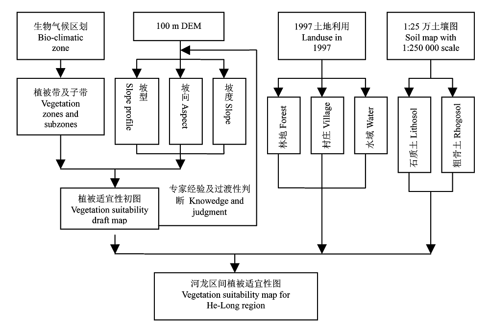
Fig. 2 Flowchart of vegetation suitability mapping based on the 100 m DEM and vegetation distribution concepts
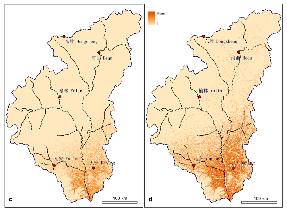
Fig. 3 Two plantation scenarios in the region and the water reduction spatial distribution
| w | η |
|---|---|
| 1.61 | 0.8 ≤ γ |
| 0.45 | 0.25≤γ < 0.8 |
| 0.1 | γ < 0.25 |
Table 2 The using criteria of parameter w in the catchments
| w | η |
|---|---|
| 1.61 | 0.8 ≤ γ |
| 0.45 | 0.25≤γ < 0.8 |
| 0.1 | γ < 0.25 |
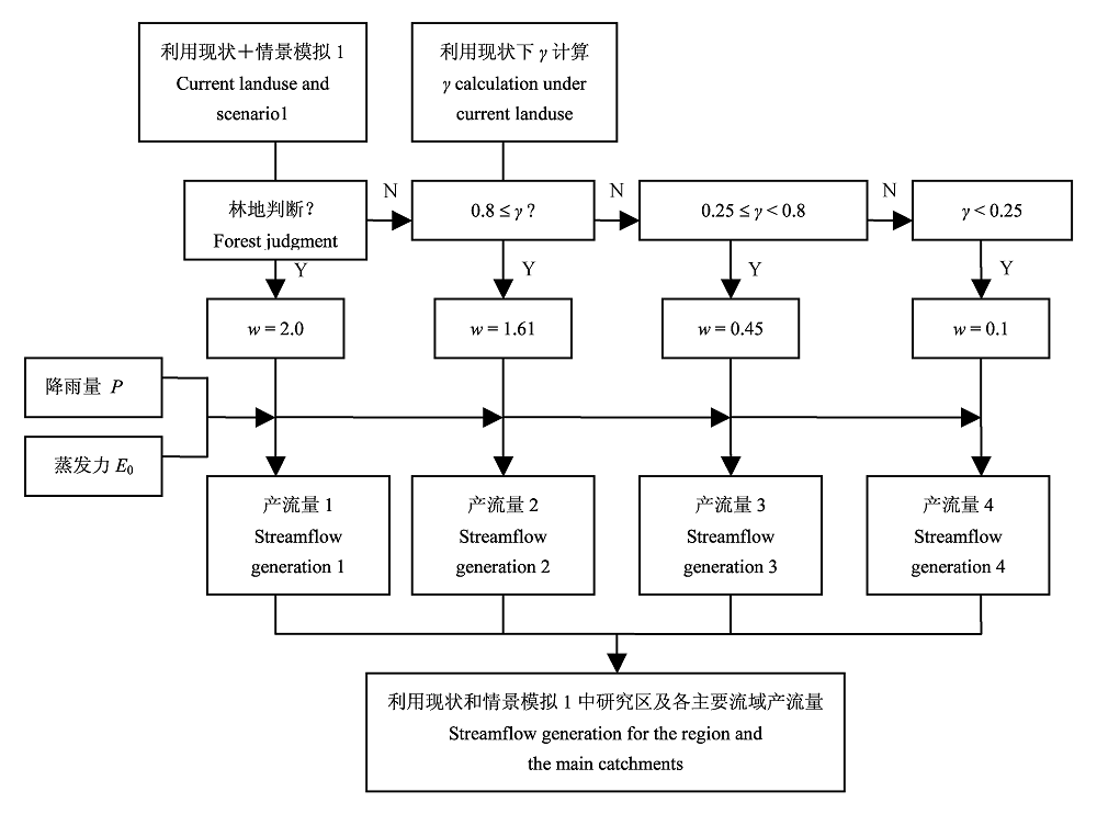
Fig. 4 Flowchart of streamflow generation under the current land use and scenario 1
| [1] | Brown AE, Zhang L, McMahon TA, Western AW, Vertessy RA (2005). A review of paired catchment studies for determining changes in water yield resulting from alteration in vegetation. Journal of Hydrology, 310,28-61. |
| [2] | Budyko MI (1974). Climate and Life. Academic Press, San Diego, USA, 508. |
| [3] | Calder IR (1999). The Blue Revolution―Land Use and Integrated Water Resources Management. Earthscan Publications, London. |
| [4] | Chen YM (陈云明), Liang YM (梁一民), Cheng JM (程积民) (2002). The zonal character of vegetation construction on Loess Plateau. Acta Phytoecologica Sinica (植物生态学报), 26,339-345. (in Chinese with English abstract) |
| [5] | Day FP, Monk CD (1974). Vegetation patterns on a southern Appalachian watershed. Ecology, 55,1064-1074. |
| [6] | Huang MB (黄明斌), Kang SZ (康绍忠), Li YS (李玉山) (1999). A comparison of hydrological behaviors of forest and grassland watersheds in gully region of the Loess Plateau. Journal of Natural Resources (自然资源学报), 14,226-231. (in Chinese with English abstract) |
| [7] | Huang MB, Zhang L, Gallichand J (2003). Runoff responses to afforestation in a watershed of the Loess Plateau, China. Hydrological Processes, 17,2599-2609. |
| [8] | Jiang DS (蒋定生), Liu MM (刘梅梅), Huang GJ (黄国俊) (1987). An initial approach to the redistribution laws of precipitation on convex and concave hill slopes. Bulletin of Soil and Water Conservation ( 水土保持通报), 1,45-50. (in Chinese with English abstract) |
| [9] | Jing K (景可), Shen YC (申元村) (2001). The serious problems urgently needing solving in ecological construction in the Loess Plateau. Soil and Water Conservation in China (中国水土保持), 2,12-13. (in Chinese) |
| [10] | Jing K (景可), Shen YC (申元村) (2002). The effect of soil conservation on surface runoff in the Loess Plateau in the future. Soil and Water Conservation in China (中国水土保持), 1,12-14. (in Chinese) |
| [11] | Li M (李勉), Yao WY (姚文艺), Chen JN (陈江南), Ding WF (丁文峰), Yang JF (杨剑锋), Li L (李莉), Yang CX (杨春霞) (2005). Experimental study on the effect of different grass coverages on the overland flow velocity. Transaction of the Chinese Society of Agricultural Engineering (农业工程学报), 21(12),43-47. (in Chinese with English abstract) |
| [12] | Lian G (连纲), Guo XD (郭旭东), Fu BJ (傅伯杰), Hu CX (虎陈霞) (2006). Spatial variability of bulk density and soil water in a small catchment of the Loess Plateau. Acta Ecologica Sinica (生态学报), 26,647-654. (in Chinese with English abstract) |
| [13] | Liu CM (刘昌明), Zhong JX (钟俊襄) (1978). The effect of forest on stream flow in the Loess Plateau. Acta Geographica Sinica (地理学报), 33,112-126. (in Chinese with English abstract) |
| [14] | Oyebande L (1988). Effects of tropical forests on water yield. In: Reynold ERC, Thompson FB eds.Forests, Climate, and Hydrology Regional Impact. Kefford Press, Singapore. |
| [15] | Pan CZ (潘成忠), Shangguan ZP (上官周平) (2004). Spatial variability of soil moisture, nutrients, and productivity on slopeland in loessial semiarid region. Chinese Journal of Applied Ecology (应用生态学报), 15,2061-2066. (in Chinese with English abstract) |
| [16] | Pan CZ (潘成忠), Shangguan ZP (上官周平) (2005). Generation mechanism of woodland runoff and sediment on Loess Plateau under hypo-rainfall ―A case study of artificial P. tabulaeformis and secondary natural P. dadidiana stands. Chinese Journal of Applied Ecology (应用生态学报), 16,1597-1602. (in Chinese with English abstract) |
| [17] | Pike JG (1964). The estimation of annual runoff from meteorological data in a tropical climate. Journal of Hydrology, 2,116-123. |
| [18] | Tan Y (谭勇), Wang CR (王长如), Liang ZS (梁宗锁), Du F (杜峰) (2006). Measures for forest and grass vegetation construction in semi-arid areas on the Loess Platteau. Acta Prataculturae Sinica (草业学报), 15(4),4-11. (in Chinese with English abstract) |
| [19] | Tang KL (唐克丽), Zhang KL (张科利), Lei AL (雷阿林) (1998). The threshold study and demonstration for the slope degree of converting slope farming land in the loess hilly gully region, China. Chinese Science Bulletin (科学通报), 43,200-203. (in Chinese with English abstract) |
| [20] | Wang YF (王义凤) (1991). The Vegetation Resources and Utilization in the Loess Plateau(黄土高原地区植被资源及其合理利用). Chinese Science and Technology Press,Beijing. (in Chinese) |
| [21] | Wu QX (吴钦孝), Yang WZ (杨文治) (1998). Vegetation Construction and Sustainable Development of Loess Plateau (黄土高原植被建设与持续发展). Science Press,Beijing. (in Chinese) |
| [22] | Xu JH (徐建华), Wang L (王玲) (2003). Analysis on water demand for vegetation rehabilitation of the Loess Plateau. Yellow River(人民黄河), 25(1),13-15. (in Chinese) |
| [23] | Yang QY (杨勤业), Yuan BY (袁宝印) (1991). Natural Environment and Its Change of the Loess Plateau (黄土高原地区自然环境及其演变). Science Press,Beijing. (in Chinese) |
| [24] | Yang WZ (杨文治), Shao MA (邵明安) (2000). Research on Soil Water of the Loess Plateau (黄土高原土壤水分研究). Science Press,Beijing. (in Chinese) |
| [25] | Zhang L, Dawes WR, Walker GR (2001). Response of mean annual evapotranspiration to vegetation changes at catchment scale. Water Resources Research, 37,701-708. |
| [26] | Zhang XP (张晓萍), Dong BR (董冰让), Li R (李锐), Yang QK (杨勤科) (2007). Study of land use and forest cover pattern change in Hekou-Longmen section of the Middle Reaches of Yellow River. Journal of Soil and Water Conservation (水土保持学报), 21(5),163-166. (in Chinese with English abstract) |
| [27] | Zhang XP, Zhang L, McVicar TR, Van Niel TG, Li LT, Li R, Yang QK, Liang W (2008). Modelling the impact of afforestation on average annual streamflow in the Loess Plateau, China. Hydrological Processes, 22,1996-2004. |
| [28] | Zhao HY (赵鸿雁), Wu QX (吴钦孝) (2001). Studies on streamflow and sediment yield in small catchment covered artificial Chinese pine stand in Loess Plateau. Progress in Natural Science (自然科学进展), 11,829-834. (in Chinese with English abstract) |
| [29] | Zhou GS (周广胜), Zhang XS (张新时) (1996). Study on Chinese climate-vegetation relationship. Acta Phytoecologica Sinica (植物生态学报), 20,113-119. (in Chinese with English abstract) |
| [30] | Zou HY (邹厚远) (2000). A study of correlation between vegetation division and construction of forest and grasslands in Loess Plateau of Northern Shaanxi. Research of Soil and Water Conservation (水土保持研究), 7(2),96-101. (in Chinese with English abstract) |
| [1] | WU Fan, WU Chen, ZHANG Yu-Hui, YU Heng, WEI Zhi-Hua, ZHENG Wei, LIU Xiao-Fei, CHEN Shi-Dong, YANG Zhi-Jie, XIONG De-Cheng. Effects of warming on growth, morphology and physiological metabolism characteristics of fine roots in a mature Cunninghamia lanceolata plantation in different seasons [J]. Chin J Plant Ecol, 2023, 47(6): 856-866. |
| [2] | LIN Shao-Ying, ZENG Yu, YANG Wen-Wen, CHEN Bin, RUAN Min-Min, YIN Xiao-Lei, YANG Xiang, WANG Wei-Qi. Effects of straw and biochar addition on carbon, nitrogen and phosphorus ecological stoichiometry in Jasminum sambac plant and soil [J]. Chin J Plant Ecol, 2023, 47(4): 530-545. |
| [3] | FAN Yun-Xiang, DI Nan, LIU Yang, ZHANG Yu-Wen, DUAN Jie, LI Xin, WANG Hai-Hong, XI Ben-Ye. Spatiotemporal dynamics of nocturnal sap flow of Populus tomentosa and environmental impact factors [J]. Chin J Plant Ecol, 2023, 47(2): 262-274. |
| [4] | TANG Lu-Yao, FANG Jing, QIAN Hai-Rong, ZHANG Bo-Na, SHANGGUAN Fang-Jing, YE Lin-Feng, LI Shu-Wen, TONG Jin-Lian, XIE Jiang-Bo. Variation and coordination in functional traits along the tree height of Taxodium distichum and Taxodium distichum var. imbricatum [J]. Chin J Plant Ecol, 2023, 47(11): 1561-1575. |
| [5] | DANG Hong-Zhong, ZHANG Xue-Li, HAN Hui, SHI Chang-Chun, GE Yu-Xiang, MA Quan-Lin, CHEN Shuai, LIU Chun-Ying. Research advances on forest-water relationships in Pinus sylvestris var. mongolica plantations for sand dune immobilization and guidance to forest management practices [J]. Chin J Plant Ecol, 2022, 46(9): 971-983. |
| [6] | LI Wan-Nian, LUO Yi-Min, HUANG Ze-Yue, YANG Mei. Effects of mixed young plantations of Parashorea chinensis on soil microbial functional diversity and carbon source utilization [J]. Chin J Plant Ecol, 2022, 46(9): 1109-1124. |
| [7] | LIU Pei-Rong, TONG Xiao-Juan, MENG Ping, ZHANG Jin-Song, ZHANG Jing-Ru, YU Pei-Yang, ZHOU Yu. Effect of diffuse radiation on gross primary productivity of typical planted forests in eastern China [J]. Chin J Plant Ecol, 2022, 46(8): 904-918. |
| [8] | HUANG Dong-Liu, XIANG Wei, LI Zhong-Guo, ZHU Shi-Dan. Hydraulic architecture and safety margin in ten afforestation species in a lower subtropical region [J]. Chin J Plant Ecol, 2022, 46(5): 602-612. |
| [9] | WANG Li-Shuang, TONG Xiao-Juan, MENG Ping, ZHANG Jin-Song, LIU Pei-Rong, LI Jun, ZHANG Jing-Ru, ZHOU Yu. Energy flux and evapotranspiration of two typical plantations in semi-arid area of western Liaoning, China [J]. Chin J Plant Ecol, 2022, 46(12): 1508-1522. |
| [10] | GAO Lu-Xin, LAN Tian-Yuan, ZHAO Zhi-Xia, DENG Shu-Yu, XIONG Gao-Ming, XIE Zong-Qiang, SHEN Guo-Zhen. Spatial turnover of shrubland communities and underlying factors in northern mid-subtropical China [J]. Chin J Plant Ecol, 2022, 46(11): 1411-1421. |
| [11] | YAN Zheng-Bing, LIU Shu-Wen, WU Jin. Hyperspectral remote sensing of plant functional traits: monitoring techniques and future advances [J]. Chin J Plant Ecol, 2022, 46(10): 1151-1166. |
| [12] | JIA Ning-Xia, GUO Ke, SONG Chuang-Ye, LIU Chang-Cheng. Principles of color and symbol design for vegetation mapping and a scheme of national vegetation map legends [J]. Chin J Plant Ecol, 2021, 45(8): 809-817. |
| [13] | YIN Xiao-Lei, LIU Xu-Yang, JIN Qiang, LI Xian-De, LIN Shao-Ying, YANG Xiang, WANG Wei-Qi, ZHANG Yong-Xun. Effects of different management methods on carbon, nitrogen, and phosphorus contents and their stoichiometric ratios in tea plants [J]. Chin J Plant Ecol, 2021, 45(7): 749-759. |
| [14] | LUO Lin, HUANG Yan, LIANG Jin, WANG En-Tao, HU Jun, HE He-Liang, ZHAO Chun-Zhang. Effects of plant interspecific interaction and warming on soil microbial community in root zone soil of two dominant tree species in the subalpine coniferous forest in southwestern China [J]. Chin J Plant Ecol, 2020, 44(8): 875-884. |
| [15] | HU Ming-Yuan, YUAN Ye, DAI Xiao-Qin, FU Xiao-Li, KOU Liang, WANG Hui-Min. Characteristics of soil nitrogen mineralization in the rhizosphere of trees, shrubs, and herbs in subtropical forest plantations [J]. Chin J Plant Ecol, 2020, 44(12): 1285-1295. |
| Viewed | ||||||
|
Full text |
|
|||||
|
Abstract |
|
|||||
Copyright © 2022 Chinese Journal of Plant Ecology
Tel: 010-62836134, 62836138, E-mail: apes@ibcas.ac.cn, cjpe@ibcas.ac.cn