
Chin J Plant Ecol ›› 2010, Vol. 34 ›› Issue (4): 359-367.DOI: 10.3773/j.issn.1005-264x.2010.04.001
• Research Articles • Next Articles
JI Yu-He1,2, ZHOU Guang-Sheng1,*( )
)
Received:2009-03-30
Accepted:2009-09-12
Online:2010-03-30
Published:2010-04-01
Contact:
ZHOU Guang-Sheng
JI Yu-He, ZHOU Guang-Sheng. Transformation of vegetation structure in China’s Liaohe Delta during 1988-2006[J]. Chin J Plant Ecol, 2010, 34(4): 359-367.
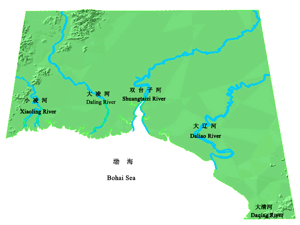
Fig. 1 The geographical location of the Liaohe Delta: east extremely to the estuary of Daqinghe river; west extremely to the estuary of Xiaolinghe river; south extremely to Bohai Sea; north extremely to the northernmost region of Panjin.
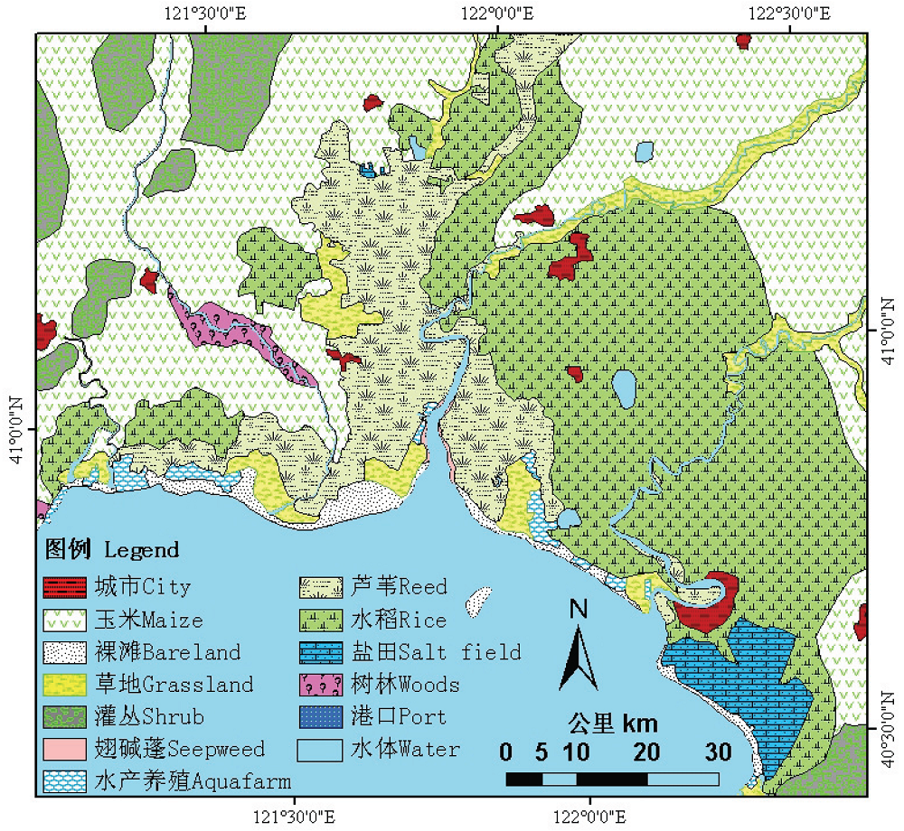
Fig. 2 The spatial distribution map of vegetation in the Liaohe Delta in 1988.
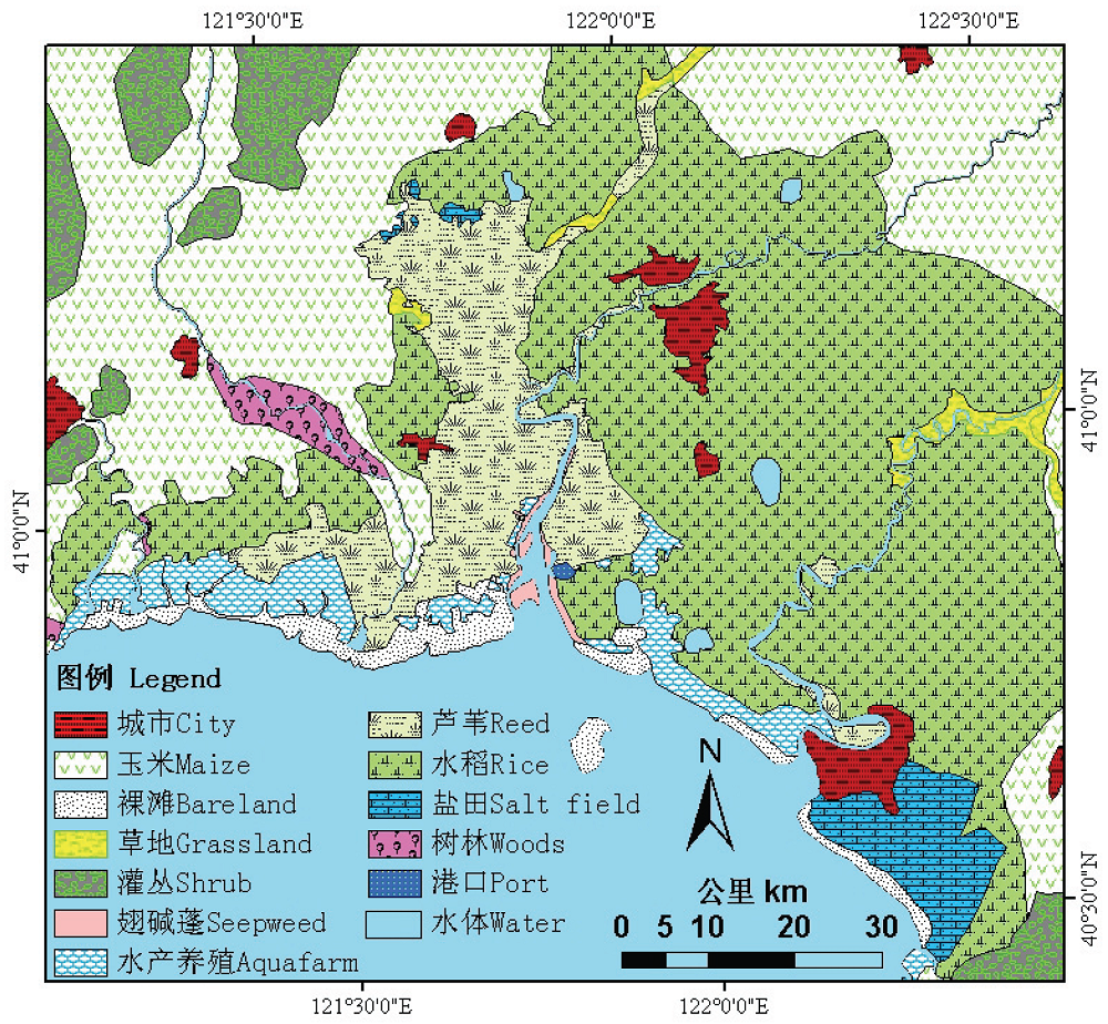
Fig. 3 The spatial distribution map of vegetation in the Liaohe Delta in 2006.
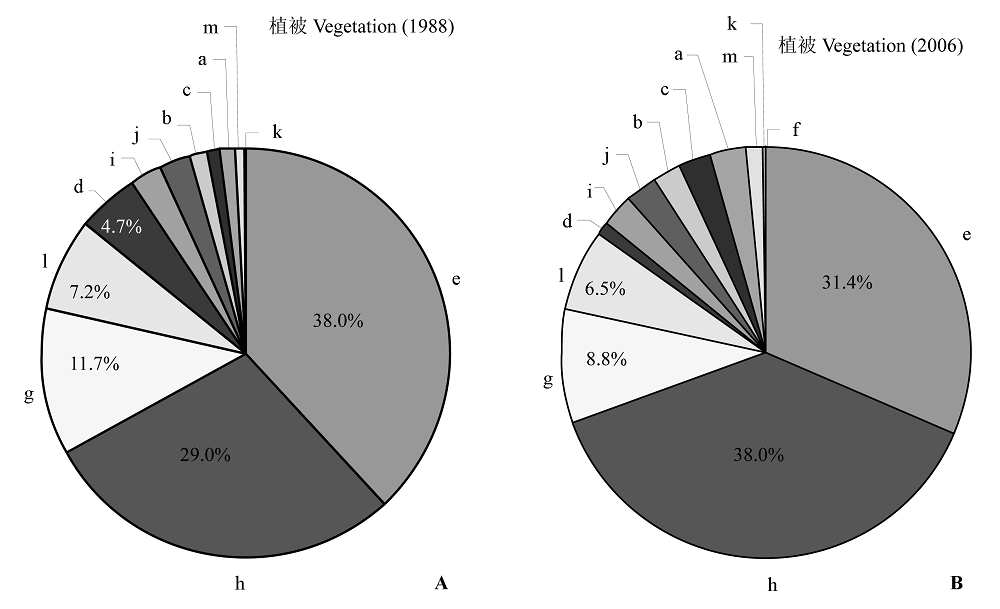
Fig. 4 The proportion map of vegetation types in the Liaohe Delta in 1988 (A) and 2006 (B). a, aquafarm; b, bareland; c, city; d, grassland; e, maize land; f, port; g, coastal wetland reed; h, rice land; i, river and lake; j, salt field; k, salt meadow seepweed; l, shrub; m, woods.
| 类型 Type | 1988 | 2006 | ||||||
|---|---|---|---|---|---|---|---|---|
| 面积 Area (km2) | 比例 Percentage (%) | 面积 Area (km2) | 比例 Percentage (%) | 变化面积 Changed area (km2) | 变幅 Changed rate (%) | |||
| 玉米地 Maize land | 3 860.8 | 27.84 | 3 238.6 | 23.36 | -622.2 | -16.1 | ||
| 海洋 Sea | 3 712.0 | 26.77 | 3 549.0 | 25.59 | -163.0 | -4.4 | ||
| 水稻田 Rice land | 2 942.9 | 21.22 | 3 920.0 | 28.27 | 977.1 | 33.2 | ||
| 滨海芦苇湿地 Coastal wetland reed | 1 188.2 | 8.57 | 912.6 | 6.58 | -275.6 | -23.2 | ||
| 灌丛 Shrub | 732.4 | 5.28 | 670.4 | 4.83 | -62.0 | -8.5 | ||
| 草地 Grassland | 474.6 | 3.42 | 104.9 | 0.76 | -369.7 | -77.9 | ||
| 河湖 River and lake | 262.8 | 1.90 | 265.8 | 1.92 | 3.0 | 1.1 | ||
| 盐田 Salt field | 228.7 | 1.65 | 258.5 | 1.86 | 29.8 | 13.0 | ||
| 裸滩 Bare land | 158.4 | 1.14 | 219.5 | 1.58 | 61.1 | 38.6 | ||
| 城市 City | 119.1 | 0.86 | 259.8 | 1.87 | 140.7 | 118.1 | ||
| 水产养殖场 Aquafarm | 91.3 | 0.66 | 326.7 | 2.36 | 235.4 | 257.8 | ||
| 树林 Woods | 86.0 | 0.62 | 107.0 | 0.77 | 21.0 | 24.4 | ||
| 翅碱蓬盐化草甸 Salt meadow seepweed | 9.1 | 0.07 | 28.4 | 0.20 | 19.3 | 212.1 | ||
| 港口 Port | 0 | 0 | 5.1 | 0.04 | 5.1 | |||
| 总计 Total | 13 866.3 | 100 | 13 866.3 | 100 | ||||
Table 1 The area and the transformation rate of vegetation types in the Liaohe Delta from1988 to 2006
| 类型 Type | 1988 | 2006 | ||||||
|---|---|---|---|---|---|---|---|---|
| 面积 Area (km2) | 比例 Percentage (%) | 面积 Area (km2) | 比例 Percentage (%) | 变化面积 Changed area (km2) | 变幅 Changed rate (%) | |||
| 玉米地 Maize land | 3 860.8 | 27.84 | 3 238.6 | 23.36 | -622.2 | -16.1 | ||
| 海洋 Sea | 3 712.0 | 26.77 | 3 549.0 | 25.59 | -163.0 | -4.4 | ||
| 水稻田 Rice land | 2 942.9 | 21.22 | 3 920.0 | 28.27 | 977.1 | 33.2 | ||
| 滨海芦苇湿地 Coastal wetland reed | 1 188.2 | 8.57 | 912.6 | 6.58 | -275.6 | -23.2 | ||
| 灌丛 Shrub | 732.4 | 5.28 | 670.4 | 4.83 | -62.0 | -8.5 | ||
| 草地 Grassland | 474.6 | 3.42 | 104.9 | 0.76 | -369.7 | -77.9 | ||
| 河湖 River and lake | 262.8 | 1.90 | 265.8 | 1.92 | 3.0 | 1.1 | ||
| 盐田 Salt field | 228.7 | 1.65 | 258.5 | 1.86 | 29.8 | 13.0 | ||
| 裸滩 Bare land | 158.4 | 1.14 | 219.5 | 1.58 | 61.1 | 38.6 | ||
| 城市 City | 119.1 | 0.86 | 259.8 | 1.87 | 140.7 | 118.1 | ||
| 水产养殖场 Aquafarm | 91.3 | 0.66 | 326.7 | 2.36 | 235.4 | 257.8 | ||
| 树林 Woods | 86.0 | 0.62 | 107.0 | 0.77 | 21.0 | 24.4 | ||
| 翅碱蓬盐化草甸 Salt meadow seepweed | 9.1 | 0.07 | 28.4 | 0.20 | 19.3 | 212.1 | ||
| 港口 Port | 0 | 0 | 5.1 | 0.04 | 5.1 | |||
| 总计 Total | 13 866.3 | 100 | 13 866.3 | 100 | ||||
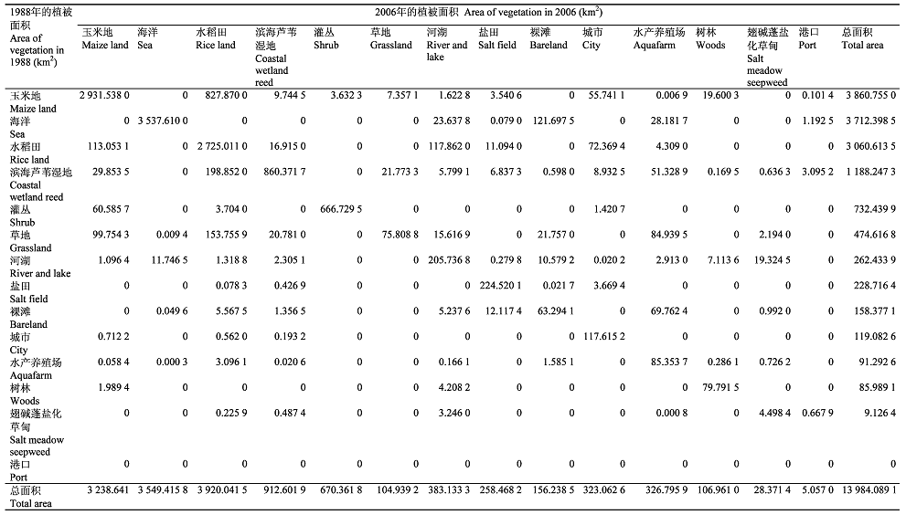 |
Table 2 The transfer matrix of vegetation types in the Liaohe Delta from 1988 to 2006
| |
| [1] |
Alados CL, Pueyo Y, Navas D, Cabezudo B, Gonzalez A, Freeman DC (2005). Fractal analysis of plant spatial patterns: a monitoring tool for vegetation transition shifts. Biodiversity and Conservation, 14, 1453-1468.
DOI URL |
| [2] |
Apan AA, Raine SR, Paterson MS (2002). Mapping and analysis of changes in the riparian landscape structure of the Lockyer Valley catchment Queensland, Australia. Landscape and Urban Planning, 59, 43-57.
DOI URL |
| [3] |
Bolliger J, Mladenoff DJ (2005). Quantifying spatial classification uncertainties of the historical Wisconsin landscape (USA). Ecography, 28, 141-156.
DOI URL |
| [4] |
Bresee MK, Moine JL, Mather S, Brosofske KD, Chen JQ, Crow TR, Rademacher J (2004). Disturbance and landscape dynamics in the Chequamegon National Forest Wisconsin, USA, from 1972 to 2001. Landscape Ecology, 19, 291-309.
DOI URL |
| [5] |
Capon SJ (2005). Flood variability and spatial variation in plant community composition and structure on a large arid floodplain. Journal of Arid Environments, 60, 283-302.
DOI URL |
| [6] | Cui HY (崔红艳) (2005). Risk analysis of potential sea-level rise base on GIS in Panjin. Journal of Jilin Normal University (吉林大学学报), (2), 5-7. (in Chinese with English abstract) |
| [7] | Dong HD (董厚德), Quan KG (全奎国), Shao C (邵成), Chen ZL (陈中林) (1995). Ecology of plant communities in Liaohe estuary wetland conservation area. Chinese Journal of Applied Ecology (应用生态学报), 6, 190-195. (in Chinese with English abstract) |
| [8] | Fu ZY (付在毅), Xu XG (许学工), Lin HP (林辉平), Wang XL (王宪礼) (2001). Regional ecological risk assessment in the Liaohe River Delta wetlands. Acta Ecologica Sinica (生态学报), 21, 365-373. (in Chinese with English abstract) |
| [9] |
Higinbotham CB, Alber M, Chalmers AG (2004). Analysis of tidal marsh vegetation patterns in two Georgia estuaries using aerial photography and GIS. Estuaries, 27, 670-683.
DOI URL |
| [10] | Huang GL (黄桂林), Zhang JJ (张建军), Han AH (韩爱慧), Zhang MX (张明祥), Zhang YW (张阳武), Dong K (董柯) (2000). The application of 3S technology in inspecting wetland. Forestry Resource Management (林业资源管理), (5), 51-56. (in Chinese) |
| [11] | Jiang WG (蒋卫国), Li J (李京), Wang WJ (王文杰), Xie ZR (谢志仁), Gong HL (宫辉力) (2005). An analysis of changes and driving forces of wetland using RS and GIS in Liaohe River Delta. Remote Sensing for Land & Resources (国土资源遥感), (3), 62-66. (in Chinese with English abstract) |
| [12] | Li J (李静), Zhao GX (赵庚星), Yang PG (杨佩国), Ma SH (马淑惠) (2008). Temporal-spatial characteristic of the land use and land cover change in the Yellow River Delta. Areal Research and Development (地域研究与开发), 27, 110-114. (in Chinese with English abstract) |
| [13] | Li JL (李加林), Zhao HB (赵寒冰), Cao YG (曹云刚), Liu C (刘闯) (2006). Analysis on change of landscape pattern of wetland in Liaohe Delta. Urban Environment & Urban Ecology (城市环境与城市生态), 19, 5-7. (in Chinese with English abstract) |
| [14] | Li XW (李晓文), Xiao DN (肖笃宁), Hu YM (胡远满) (2001). The landscape planning scenarios designing and the measures identification in the Liaohe River Delta wetland. Acta Ecologica Sinica (生态学报), 21, 353-365. (in Chinese with English abstract) |
| [15] | Li YC (2008). Land cover dynamic changes in northern China: 1989-2003. Journal of Geography Sciences, 18, 85-94. |
| [16] | Liu HY (刘红玉), Lü XG (吕宪国), Liu ZQ (刘振乾) (2001). Deltaic wetlands in Bohai Sea: resources and development. Journal of Natural Resources (自然资源学报), 16, 101-107. (in Chinese with English abstract) |
| [17] | Liu YF (刘岳峰), Wu L (邬伦), Hu YM (胡远满), Han MK (韩慕康), Ren JS (任劲松) (1998). Assessment of trend and impacts of sea level rise in the Liaohe River Delta. Acta Oceanologica Sinica (海洋学报), 20, 73-82. (in Chinese with English abstract) |
| [18] | Liu ZQ (刘振乾), Lü XG (吕宪国), Liu HY (刘红玉) (2000). Comparative study on wetlands in Huanghe and Liaohe Deltas. Resources Science (资源科学), 22(3), 60-65. (in Chinese with English abstract) |
| [19] | Liu ZQ (刘振乾), Xu XL (徐新良), Lü XG (吕宪国) (1999). The application of 3S technology in studying on wetland resource. Geography and Territorial Research (地理学与国土研究), 15, 87-91. (in Chinese) |
| [20] | Luan WX (栾维新), Cui HY (崔红艳) (2004). Submerged loss assessment of potential sea-level rise of Liao River Delta region based on GIS. Geographical Research (地理研究), 23, 805-814. (in Chinese with English abstract) |
| [21] | Luque SS (2000). Evaluating temporal changes using Multi-Spectral Scanner and Thematic Mapper data on the landscape of a natural reserve: the New Jersey Pine Barrens, a case study. Internal Journal of Remote Sensing, 21, 2589-2610. |
| [22] |
Petersen SL, Stringham TK (2008). Development of GIS-based models to predict plant community structure in relation to western juniper establishment. Forest Ecology and Management, 256, 981-989.
DOI URL |
| [23] |
Shirley LJ, Battaglia LL (2006). Assessing vegetation change in coastal landscapes of the Northern Gulf of Mexico. Wetlands, 26, 1057-1070.
DOI URL |
| [24] | Tang L (汤蕾), Xu D (许东), Mu XZ (母学征) (2006). Change in ecosystem service values in Liaohe River Delta. Research of Soil and Water Conservation (水土保持研究), 13(5), 108-110. (in Chinese with English abstract) |
| [25] |
Timoney K (2008). Rates of vegetation change in the Peace-Athabasca delta. Wetlands, 28, 513-520.
DOI URL |
| [26] |
Tong PHS, Auda Y, Populus J, Aizpuru M, Habshi AA, Blasco F (2004). Assessment from space of mangroves evolution in the Mekong Delta in relation to extensive shrimp farming. International Journal of Remote Sensing, 25, 4795-4812.
DOI URL |
| [27] |
Vogiatzakis IN, Griffiths GH (2006). A GIS-based empirical model for vegetation prediction in Lefka Ori, Crete. Plant Ecology, 184, 311-323.
DOI URL |
| [28] | Wang L (王凌), Li XZ (李秀珍), Guo DF (郭笃发) (2003). Land use change and consequences in the Liaohe Delta. Journal of Shandong Normal University (Natural Science) 山东师范大学学报(自然科学版)), 18(3), 43-47. (in Chinese with English abstract) |
| [29] | Wang XL (王宪礼), Bu RC (布仁仓), Hu YM (胡远满), Xiao DN (肖笃宁) (1996). Analysis on landscape fragment of Liaohe Delta Wetlands. Chinese Journal of Applied Ecology (应用生态学报), 7, 299-304. (in Chinese with English abstract) |
| [30] | Wu XP (吴晓莆), Tang ZY (唐志尧), Cui HT (崔海亭), Fang JY (方精云) (2006). Land cover dynamics of different topographic conditions in Beijing. Journal of Plant Ecology (Chinese Version) (植物生态学报), 30, 239-251. (in Chinese with English abstract) |
| [31] |
Wu JX, Cheng X, Xiao HS, Wang HQ, Yang LZ, Ellis EC (2009). Agricultural landscape change in China’s Yangtze Delta, 1942-2002: a case study. Agriculture, Ecosystems and Environment, 129, 523-533.
DOI URL |
| [32] | Xiao DN (肖笃宁) (1994). Natural resources and regional exploitation in the Liaohe River Delta. Journal of Natural Resources (自然资源学报), 9, 43-51. (in Chinese with English abstract) |
| [33] | Xiao DN (肖笃宁), Han MK (韩慕康), Li XW (李晓文), Liu YF (刘岳峰) (2003). Sea level rising around Bohai Sea and deltaic wetlands protection. Quaternary Sciences (第四纪研究), 23, 237-246. (in Chinese with English abstract) |
| [34] | Xiao DN (肖笃宁), Hu YM (胡远满), Li XZ (李秀珍) (2001). Landscape Ecology Research in the Deltaic Wetland Around Bohai Sea (环渤海三角洲湿地的景观生态学研究) 1st edn. Science Press, Beijing. 56-57. (in Chinese) |
| [35] |
Yang XJ (2005). Remote sensing and GIS applications for estuarine ecosystem analysis: an overview. International Journal of Remote Sensing, 26, 5347-5356.
DOI URL |
| [36] | Zhao Y (赵弈), Li YH (李月辉), Cao Y (曹宇) (2000). Flood prevention function of Panjin wetland at Liaohe Delta. Chinese Journal of Applied Ecology (应用生态学报), 11, 261-264. (in Chinese with English abstract) |
| [1] | Xue-Qi GENG YA-KUN TANG WANG LiNa Xu DENG Ze-ling ZHANG Ying ZHOU. Nitrogen addition increases the biomass of Chinese terrestrial plants but reduces their Nitrogen use efficiency [J]. Chin J Plant Ecol, 2024, 48(预发表): 0-0. |
| [2] | . Involvements of mycorrhizal fungi in terrestrial ecosystem carbon cycling [J]. Chin J Plant Ecol, 2024, 48(1): 0-0. |
| [3] | ZHANG Zhong-Yang, SONG Xi-Qiang, REN Ming-Xun, ZHANG Zhe. Ecological functions of vascular epiphytes in habitat construction [J]. Chin J Plant Ecol, 2023, 47(7): 895-911. |
| [4] | LÜ Zi-Li, LIU Bin, CHANG Feng, MA Zi-Jing, CAO Qiu-Mei. Relationship between plant functional diversity and ecosystem multifunctionality in Bayanbulak alpine meadow along an altitude gradient [J]. Chin J Plant Ecol, 2023, 47(6): 822-832. |
| [5] | WANG Xiao-Yue, XU Yi-Xin, LI Chun-Huan, YU Hai-Long, HUANG Ju-Ying. Changes of plant biomass, species diversity, and their influencing factors in a desert steppe of northwestern China under long-term changing precipitation [J]. Chin J Plant Ecol, 2023, 47(4): 479-490. |
| [6] | XI Nian-Xun, ZHANG Yuan-Ye, ZHOU Shu-Rong. Plant-soil feedbacks in community ecology [J]. Chin J Plant Ecol, 2023, 47(2): 170-182. |
| [7] | WANG Wen-Wei, HAN Wei-Peng, LIU Wen-Wen. Short-term response of leaf functional traits of the invasive plant Spartina alterniflora to a tidal gradient in coastal wetlands [J]. Chin J Plant Ecol, 2023, 47(2): 216-226. |
| [8] | ZHANG Yao, CHEN Lan, WANG Jie-Ying, LI Yi, WANG Jun, GUO Yao-Xin, REN Cheng-Jie, BAI Hong-Ying, SUN Hao-Tian, ZHAO Fa-Zhu. Differences and influencing factors of microbial carbon use efficiency in forest rhizosphere soils at different altitudes in Taibai Mountain, China [J]. Chin J Plant Ecol, 2023, 47(2): 275-288. |
| [9] | LI Jie, HAO Min-Hui, FAN Chun-Yu, ZHANG Chun-Yu, ZHAO Xiu-Hai. Effect of tree species and functional diversity on ecosystem multifunctionality in temperate forests of northeast China [J]. Chin J Plant Ecol, 2023, 47(11): 1507-1522. |
| [10] | YANG Yuan-He, ZHANG Dian-Ye, WEI Bin, LIU Yang, FENG Xue-Hui, MAO Chao, XU Wei-Jie, HE Mei, WANG Lu, ZHENG Zhi-Hu, WANG Yuan-Yuan, CHEN Lei-Yi, PENG Yun-Feng. Nonlinear responses of community diversity, carbon and nitrogen cycles of grassland ecosystems to external nitrogen input [J]. Chin J Plant Ecol, 2023, 47(1): 1-24. |
| [11] | HAN Cong, LIU Peng, MU Yan-Mei, YUAN Yuan, HAO Shao-Rong, TIAN Yun, ZHA Tian-Shan, JIA Xin. Response of ecosystem carbon balance to asymmetric daytime vs nighttime warming in Artemisia ordosica shrublands [J]. Chin J Plant Ecol, 2022, 46(12): 1473-1485. |
| [12] | WU Lin-Sheng, ZHANG Yong-Guang, ZHANG Zhao-Ying, ZHANG Xiao-Kang, WU Yun-Fei. Remote sensing of solar-induced chlorophyll fluorescence and its applications in terrestrial ecosystem monitoring [J]. Chin J Plant Ecol, 2022, 46(10): 1167-1199. |
| [13] | WANG Jia-Tong, NIU Chun-Yue, HU Tian-Yu, LI Wen-Kai, LIU Ling-Li, GUO Qing-Hua, SU Yan-Jun. Three-dimensional radiative transfer modeling of forest: recent progress, applications, and future opportunities [J]. Chin J Plant Ecol, 2022, 46(10): 1200-1218. |
| [14] | XU Meng, TIAN Da-Shuan, WANG Yi-Heng, HE Yi-Cheng, CUI Qing-Guo, LI Yue-Lin, SHEN Xiao-Li, YUAN Zuo-Qiang, WANG Yang. Construction and application of the indicator system for ecosystem monitoring network in the protected areas on a national scale [J]. Chin J Plant Ecol, 2022, 46(10): 1219-1233. |
| [15] | JIA Ning-Xia, GUO Ke, SONG Chuang-Ye, LIU Chang-Cheng. Principles of color and symbol design for vegetation mapping and a scheme of national vegetation map legends [J]. Chin J Plant Ecol, 2021, 45(8): 809-817. |
| Viewed | ||||||
|
Full text |
|
|||||
|
Abstract |
|
|||||
Copyright © 2022 Chinese Journal of Plant Ecology
Tel: 010-62836134, 62836138, E-mail: apes@ibcas.ac.cn, cjpe@ibcas.ac.cn