
Chin J Plant Ecol ›› 2007, Vol. 31 ›› Issue (5): 842-849.DOI: 10.17521/cjpe.2007.0106
• Research Articles • Previous Articles Next Articles
ZHANG Yun-Xia1,2, LI Xiao-Bing1,*( ), ZHANG Yun-Fei3
Received:2006-02-01
Accepted:2006-09-13
Online:2007-02-01
Published:2007-09-30
Contact:
LI Xiao-Bing
ZHANG Yun-Xia, LI Xiao-Bing, ZHANG Yun-Fei. DETERMINING VEGETATION COVER BASED ON FIELD DATA AND MULTI-SCALE REMOTELY SENSED DATA[J]. Chin J Plant Ecol, 2007, 31(5): 842-849.
Add to citation manager EndNote|Ris|BibTeX
URL: https://www.plant-ecology.com/EN/10.17521/cjpe.2007.0106
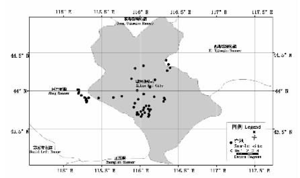
Fig.1 The distribution of sample sites in the study area
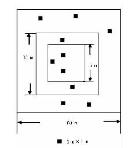
Fig.2 The sketch map of nesting sample plot
| 数据 Data | 年-月-日 Year-month-day | 波段 Band | 分辨率 Resolution | 图像质量 Imagine quality | |||||||||||||
|---|---|---|---|---|---|---|---|---|---|---|---|---|---|---|---|---|---|
| MODIS | 2002-7-30 | 1, 2 | 250 m | 较好 Better | |||||||||||||
| ASTER | 2002-7-30 | 1, 2, 3 | 15 m | 一般 Generic | |||||||||||||
Table 1 Remotely sensed data listing
| 数据 Data | 年-月-日 Year-month-day | 波段 Band | 分辨率 Resolution | 图像质量 Imagine quality | |||||||||||||
|---|---|---|---|---|---|---|---|---|---|---|---|---|---|---|---|---|---|
| MODIS | 2002-7-30 | 1, 2 | 250 m | 较好 Better | |||||||||||||
| ASTER | 2002-7-30 | 1, 2, 3 | 15 m | 一般 Generic | |||||||||||||
| 植被指数 Vegetation index | 计算公式 Calculating formula |
|---|---|
| 归一化植被指数NDVI | (NIR-R)/(NIR+R) |
| 归一化差异绿度指数NDGI | (G-R)/(G+R) |
| 比值植被指数RVI | R/NIR |
Table 2 Vegetation index listing
| 植被指数 Vegetation index | 计算公式 Calculating formula |
|---|---|
| 归一化植被指数NDVI | (NIR-R)/(NIR+R) |
| 归一化差异绿度指数NDGI | (G-R)/(G+R) |
| 比值植被指数RVI | R/NIR |
| 样方大小 The size of sample sites (m×m) | ASTER影像 ASTER images (像元×像元)(pixel×pixel) |
|---|---|
| 15×15 | 1×1 |
| 30×30 | 2×2 |
| 60×60 | 4×4 |
Table 3 The matching scheme between the sizes of sample sites and the pixels of ASTER image
| 样方大小 The size of sample sites (m×m) | ASTER影像 ASTER images (像元×像元)(pixel×pixel) |
|---|---|
| 15×15 | 1×1 |
| 30×30 | 2×2 |
| 60×60 | 4×4 |
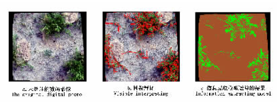
Fig.3 Results of estimating vegetation fractional coverage of digital photos by different methods
| 相片号 Photo number | 相对误差 Relative error (%) | 相片号 Photo number | 相对误差 Relative error (%) |
|---|---|---|---|
| 1 | 19.9 | 17 | 18.7 |
| 2 | 19.8 | 18 | 20.0 |
| 3 | 19.9 | 19 | 10.5 |
| 4 | 20.0 | 20 | 20.0 |
| 5 | 20.0 | 21 | 19.9 |
| 6 | 20.4 | 22 | 20.0 |
| 7 | 20.0 | 23 | 20.0 |
| 8 | 20.2 | 24 | 20.0 |
| 9 | 20.0 | 25 | 19.9 |
| 10 | 2.8 | 26 | 20.0 |
| 11 | 1.9 | 27 | 20.0 |
| 12 | 20.0 | 28 | 3.4 |
| 13 | 8.2 | 29 | 19.9 |
| 14 | 1.0 | 30 | 20.0 |
| 15 | 20.0 | 31 | 16.7 |
| 16 | 20.0 | 32 | 2.1 |
Table 4 The relative error of information extracting model
| 相片号 Photo number | 相对误差 Relative error (%) | 相片号 Photo number | 相对误差 Relative error (%) |
|---|---|---|---|
| 1 | 19.9 | 17 | 18.7 |
| 2 | 19.8 | 18 | 20.0 |
| 3 | 19.9 | 19 | 10.5 |
| 4 | 20.0 | 20 | 20.0 |
| 5 | 20.0 | 21 | 19.9 |
| 6 | 20.4 | 22 | 20.0 |
| 7 | 20.0 | 23 | 20.0 |
| 8 | 20.2 | 24 | 20.0 |
| 9 | 20.0 | 25 | 19.9 |
| 10 | 2.8 | 26 | 20.0 |
| 11 | 1.9 | 27 | 20.0 |
| 12 | 20.0 | 28 | 3.4 |
| 13 | 8.2 | 29 | 19.9 |
| 14 | 1.0 | 30 | 20.0 |
| 15 | 20.0 | 31 | 16.7 |
| 16 | 20.0 | 32 | 2.1 |
| 模型 Model | 植被指数 Vegetation index | 样地尺度 Sample size (m×m) | a | b | c | R |
|---|---|---|---|---|---|---|
| 线性 | NDVI | 15×15 | 0.350 | 0.153 | — | 0.573** |
| Linear | 30×30 | 0.412 | 0.170 | — | 0.602*** | |
| 60×60 | 0.480 | 0.170 | — | 0.655*** | ||
| 非线性 | 15×15 | 0.161 | 0.259 | 0.151 | 0.579** | |
| Non linear | 30×30 | 0.053 | 0.387 | 0.169 | 0.602*** | |
| 60×60 | -0.076 | 0.516 | 0.171 | 0.656*** | ||
| 线性 | NDGI | 15×15 | 0.595 | 0.053 | — | 0.507* |
| Linear | 30×30 | 0.818 | 0.036 | — | 0.552* | |
| 60×60 | 0.948 | 0.011 | — | 0.608*** | ||
| 非线性 | 15×15 | 1.161 | -0.206 | 0.154 | 0.538* | |
| Non linear | 30×30 | 1.607 | -0.121 | 0.142 | 0.570** | |
| 60×60 | 0.233 | 0.812 | 0.027 | 0.608*** | ||
| 线性 | RVI | 15×15 | -1.232 | 0.086 | — | 0.506* |
| Linear | 30×30 | -1.727 | 0.075 | — | 0.577** | |
| 60×60 | -1.907 | 0.062 | — | 0.598** | ||
| 非线性 | 15×15 | 5.924 | 0.195 | 0.141 | 0.541* | |
| Non linear | 30×30 | 7.587 | -0.083 | 0.135 | 0.596** | |
| 60×60 | 6.952 | -0.394 | 0.119 | 0.612*** |
Table 5 The first stage experiential models(n=20)
| 模型 Model | 植被指数 Vegetation index | 样地尺度 Sample size (m×m) | a | b | c | R |
|---|---|---|---|---|---|---|
| 线性 | NDVI | 15×15 | 0.350 | 0.153 | — | 0.573** |
| Linear | 30×30 | 0.412 | 0.170 | — | 0.602*** | |
| 60×60 | 0.480 | 0.170 | — | 0.655*** | ||
| 非线性 | 15×15 | 0.161 | 0.259 | 0.151 | 0.579** | |
| Non linear | 30×30 | 0.053 | 0.387 | 0.169 | 0.602*** | |
| 60×60 | -0.076 | 0.516 | 0.171 | 0.656*** | ||
| 线性 | NDGI | 15×15 | 0.595 | 0.053 | — | 0.507* |
| Linear | 30×30 | 0.818 | 0.036 | — | 0.552* | |
| 60×60 | 0.948 | 0.011 | — | 0.608*** | ||
| 非线性 | 15×15 | 1.161 | -0.206 | 0.154 | 0.538* | |
| Non linear | 30×30 | 1.607 | -0.121 | 0.142 | 0.570** | |
| 60×60 | 0.233 | 0.812 | 0.027 | 0.608*** | ||
| 线性 | RVI | 15×15 | -1.232 | 0.086 | — | 0.506* |
| Linear | 30×30 | -1.727 | 0.075 | — | 0.577** | |
| 60×60 | -1.907 | 0.062 | — | 0.598** | ||
| 非线性 | 15×15 | 5.924 | 0.195 | 0.141 | 0.541* | |
| Non linear | 30×30 | 7.587 | -0.083 | 0.135 | 0.596** | |
| 60×60 | 6.952 | -0.394 | 0.119 | 0.612*** |
| 模型 Model | 植被指数 Vegetation index | a | b | c | R |
|---|---|---|---|---|---|
| 线性 Linear | NDVI | 0.711 | -0.043 | — | 0.640** |
| 非线性 Non linear | 1.395 | -0.343 | 0.144 | 0.656** | |
| 线性 Linear | RVI | -0.506 | 0.434 | — | 0.577* |
| 非线性 Non linear | 3.201 | -3.503 | 1.112 | 0.717** |
Table 6 The second stage experiential models (n=20)
| 模型 Model | 植被指数 Vegetation index | a | b | c | R |
|---|---|---|---|---|---|
| 线性 Linear | NDVI | 0.711 | -0.043 | — | 0.640** |
| 非线性 Non linear | 1.395 | -0.343 | 0.144 | 0.656** | |
| 线性 Linear | RVI | -0.506 | 0.434 | — | 0.577* |
| 非线性 Non linear | 3.201 | -3.503 | 1.112 | 0.717** |
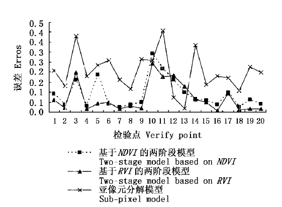
Fig.4 Errors of different models based on MODIS data
| [1] | Fazakas Z, Nilsson M (1996). Volume and forest cover estimation over southern sweden using AVHRR data calibrated with TM data. International Journal of Remote Sensing, 17,1701-1709. |
| [2] | Ignatov GGA (1998). The derivation of the green vegetation fraction from NOAA/AVHRR data for use in numerical weather prediction models. International Journal of Remote Sensing, 19,1533-1543. |
| [3] | Liu HP (刘慧平), Zhu QJ (朱启疆) (1999). Studies of methodologies and their development on land-use/cover change detection by using high spatial resolution remote sensing data. Resources Science (资源科学), 21(3),23-27. (in Chinese with English abstract) |
| [4] | Peter MA, Curran PJ (1997). Choosing an appropriate spatial resolution for remote sensing investigations. Photogrammetric Engineering & Remote Sensing, 63,1345-1351. |
| [5] | Purevdorj TS, Tateishi R, Ishiyama T, Honda Y (1998). Relationships between percent vegetation cover and vegetation indices. International Journal of Remote Sensing, 19,3519-3535. |
| [6] | Qi J, Marsett RC, Moran MS, Goodrich DC, Heilman P, Kerr Y, Dedieu G, Chehbouni A, Zhang Y (2000). Spatial and temporal dynamics of vegetation in the San Pedro River Basin area. Agricultural and Forest Meteorology, 105,55-68. |
| [7] | Yang J, Prince SD (2000). Remote sensing of savanna vegetation changes in eastern Zambia 1972-1989. International Journal of Remote Sensing, 21,301-322. |
| [8] | Zhang RH (张仁华), Sun XM (孙晓敏), Zhu ZL (朱治林) (1997). Scale transformation and realistic quantitative remote sensing in IMGRASS. Climatic and Environmental Research (气候与环境研究), 2,310-315. (in Chinese with English abstract) |
| [1] | LI Na, TANG Shi-Ming, GUO Jian-Ying, TIAN Ru, WANG Shan, HU Bing, LUO Yong-Hong, XU Zhu-Wen. Meta-analysis of effects of grazing on plant community properties in Nei Mongol grassland [J]. Chin J Plant Ecol, 2023, 47(9): 1256-1269. |
| [2] | CHEN Ying-Jie, FANG Kai, QIN Shu-Qi, GUO Yan-Jun, YANG Yuan-He. Spatial patterns and determinants of soil organic carbon component contents and decomposition rate in temperate grasslands of Nei Mongol, China [J]. Chin J Plant Ecol, 2023, 47(9): 1245-1255. |
| [3] | ZHAO Yan-Chao, CHEN Li-Tong. Soil nutrients modulate response of aboveground biomass to warming in alpine grassland on the Qingzang Plateau [J]. Chin J Plant Ecol, 2023, 47(8): 1071-1081. |
| [4] | ZHANG Qi, FENG Ke, CHANG Zhi-Hui, HE Shuang-Hui, XU Wei-Qi. Effects of shrub encroachment on plant and soil microbial in the forest-grassland ecotone [J]. Chin J Plant Ecol, 2023, 47(6): 770-781. |
| [5] | MIAO Li-Juan, ZHANG Yu-Yang, CHUAI Xiao-Wei, BAO Gang, HE Yu, ZHU Jing-Wen. Effects of climatic factors and their time-lag on grassland NDVI in Asian drylands [J]. Chin J Plant Ecol, 2023, 47(10): 1375-1385. |
| [6] | WANG De-Li, LIANG Cun-Zhu. Restoration state of degraded grasslands: climate climax or disturbance climax? [J]. Chin J Plant Ecol, 2023, 47(10): 1464-1470. |
| [7] | LIN Ma-Zhen, HUANG Yong, LI Yang, SUN Jian. Geographical distribution characteristics and influencing factors of plant survival strategies in an alpine grassland [J]. Chin J Plant Ecol, 2023, 47(1): 41-50. |
| [8] | YANG Yuan-He, ZHANG Dian-Ye, WEI Bin, LIU Yang, FENG Xue-Hui, MAO Chao, XU Wei-Jie, HE Mei, WANG Lu, ZHENG Zhi-Hu, WANG Yuan-Yuan, CHEN Lei-Yi, PENG Yun-Feng. Nonlinear responses of community diversity, carbon and nitrogen cycles of grassland ecosystems to external nitrogen input [J]. Chin J Plant Ecol, 2023, 47(1): 1-24. |
| [9] | DONG Quan-Min, ZHAO Xin-Quan, LIU Yu-Zhen, FENG Bin, YU Yang, YANG Xiao-Xia, ZHANG Chun-Ping, CAO Quan, LIU Wen-Ting. Effects of different herbivore assemblage on relationship between Kobresia humilis seed size and seed number in an alpine grassland [J]. Chin J Plant Ecol, 2022, 46(9): 1018-1026. |
| [10] | DONG Liu-Wen, REN Zheng-Wei, ZHANG Rui, XIE Chen-Di, ZHOU Xiao-Long. Functional diversity rather than species diversity can explain community biomass variation following short-term nitrogen addition in an alpine grassland [J]. Chin J Plant Ecol, 2022, 46(8): 871-881. |
| [11] | BAI Yue, LIU Chen, HUANG Yue, DONG Ya-Nan, WANG Lu. Response of spatial heterogeneity of plant community height to different herbivore assemblages in Horqin sandy grassland [J]. Chin J Plant Ecol, 2022, 46(4): 394-404. |
| [12] | WU Zan, PENG Yun-Feng, YANG Gui-Biao, LI Qin-Lu, LIU Yang, MA Li-Hua, YANG Yuan-He, JIANG Xian-Jun. Effects of land degradation on soil and microbial stoichiometry in Qingzang Plateau alpine grasslands [J]. Chin J Plant Ecol, 2022, 46(4): 461-472. |
| [13] | CHEN Li, TIAN Xin-Min, REN Zheng-Wei, DONG Liu-Wen, XIE Chen-Di, ZHOU Xiao-Long. Effects of nutrient addition on plant diversity and above-ground biomass in alpine grasslands of Tianshan Mountains, China [J]. Chin J Plant Ecol, 2022, 46(3): 280-289. |
| [14] | WANG Yan-Bing, YOU Cui-Hai, TAN Xing-Ru, CHEN Bo-Yu, XU Meng-Zhen, CHEN Shi-Ping. Seasonal and interannual variations in energy balance closure over arid and semi-arid grasslands in northern China [J]. Chin J Plant Ecol, 2022, 46(12): 1448-1460. |
| [15] | LIU Chao, LI Ping, WU Yun-Tao, PAN Sheng-Nan, JIA Zhou, LIU Ling-Li. Estimation of grassland aboveground biomass using digital photograph and canopy structure measurements [J]. Chin J Plant Ecol, 2022, 46(10): 1280-1288. |
| Viewed | ||||||
|
Full text |
|
|||||
|
Abstract |
|
|||||
Copyright © 2022 Chinese Journal of Plant Ecology
Tel: 010-62836134, 62836138, E-mail: apes@ibcas.ac.cn, cjpe@ibcas.ac.cn