
Chin J Plant Ecol ›› 2012, Vol. 36 ›› Issue (12): 1237-1247.DOI: 10.3724/SP.J.1258.2012.01237
Special Issue: 青藏高原植物生态学:遥感生态学
• Research Articles • Previous Articles Next Articles
YE Hui1,2, WANG Jun-Bang2,*( ), HUANG Mei2, QI Shu-Hua1
Received:2012-02-20
Accepted:2012-05-12
Online:2012-02-20
Published:2012-11-28
Contact:
WANG Jun-Bang
YE Hui, WANG Jun-Bang, HUANG Mei, QI Shu-Hua. Spatial pattern of vegetation precipitation use efficiency and its response to precipitation and temperature on the Qinghai-Xizang Plateau of China[J]. Chin J Plant Ecol, 2012, 36(12): 1237-1247.
Add to citation manager EndNote|Ris|BibTeX
URL: https://www.plant-ecology.com/EN/10.3724/SP.J.1258.2012.01237
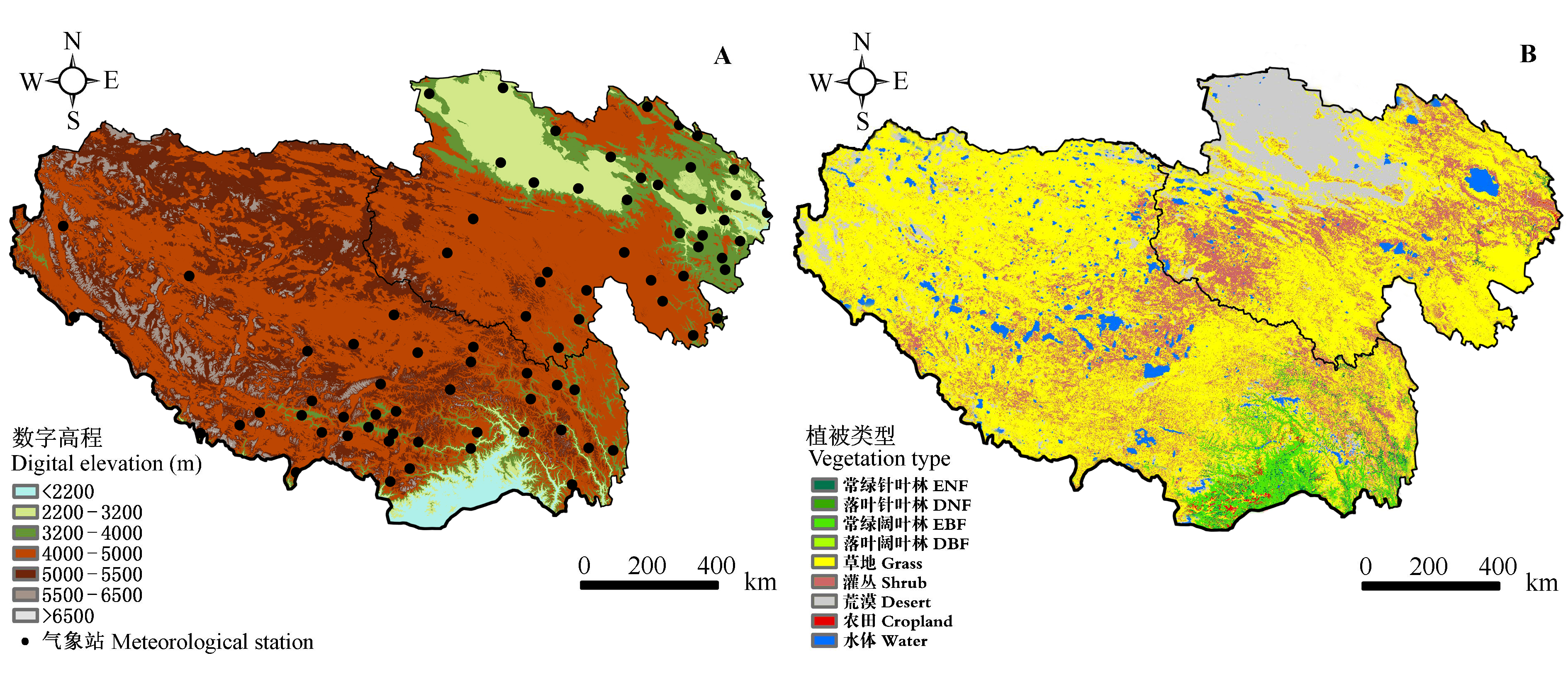
Fig. 1 Location of study sites and meteorological station and digital elevation model (DEM) data (A) used in meteorological data interpolation, and vegetation map (B) as an input data in GLOPEM-CEVSA model. DBF, deciduous broad-leaved forest; DNF, deciduous needleleaf forest; EBF, evergreen broad-leaved forest; ENF, evergreen needleleaf forest.
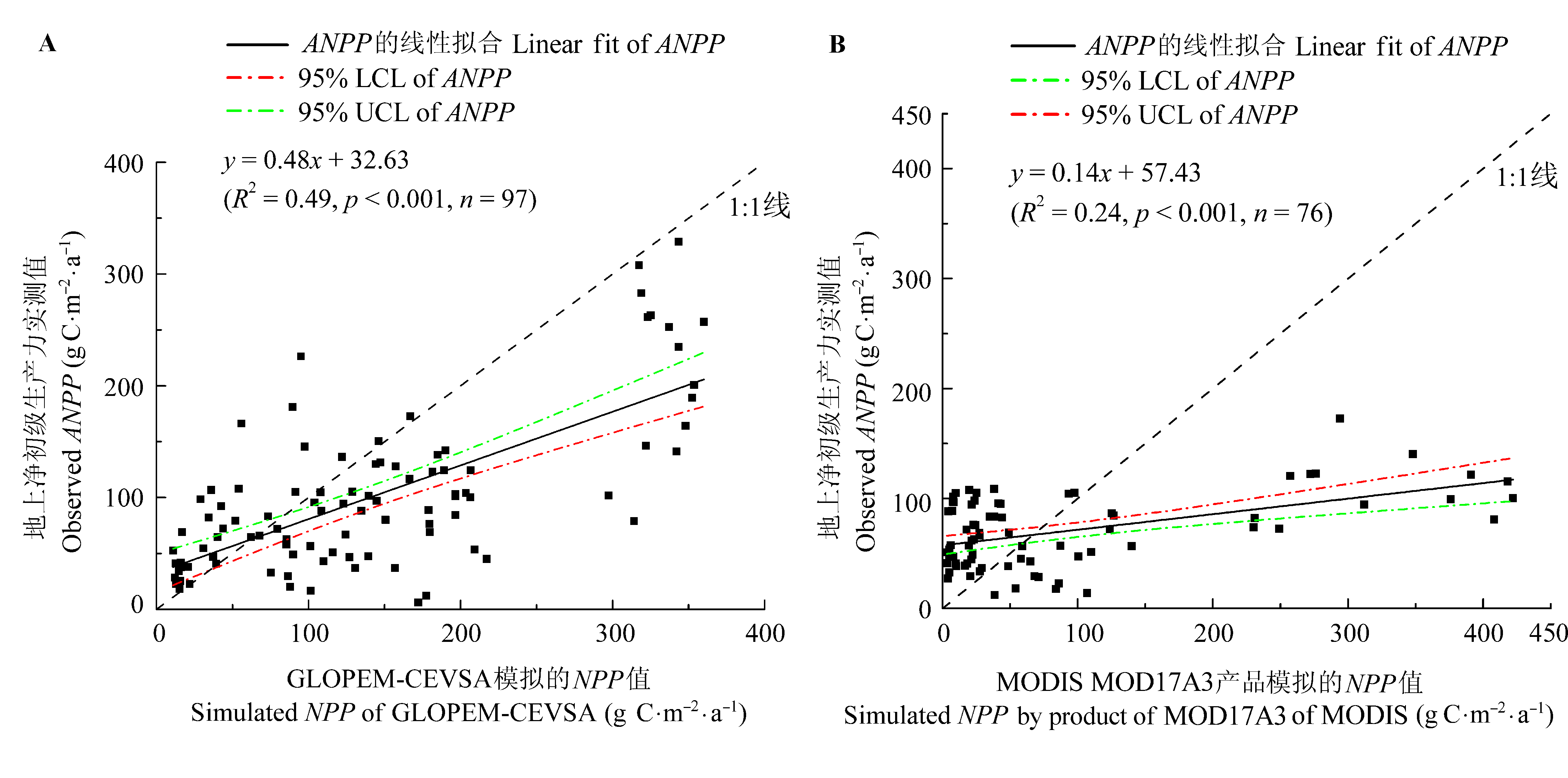
Fig. 2 Simulated net primary productivity (NPP) by GLOPEM-CEVSA model (A) and the land product (MOD17A3) of MODIS (B) was significantly correlated with the observed above-ground net primary productivity (ANPP) on Qinghai-Xizang Plateau. LCL, lower confidence limit; UCL, upper confidence limit.
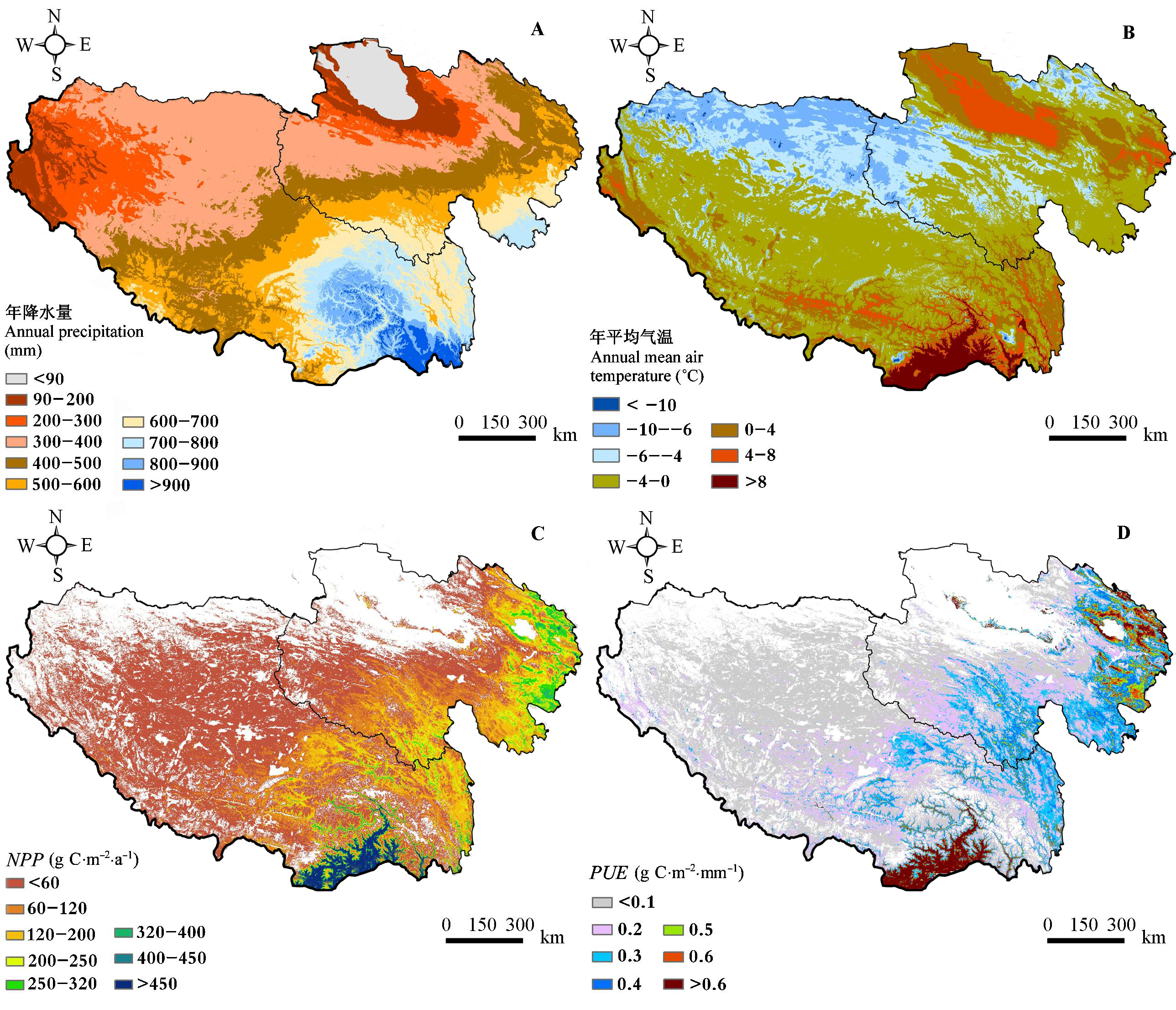
Fig. 3 Spatial patterns of annual precipitation (A), annual mean air temperature (B), net primary productivity (NPP) (C) and precipitation use efficiency (PUE) (D) of the vegetation on the Qinghai-Xizang Plateau from 2000 to 2008.
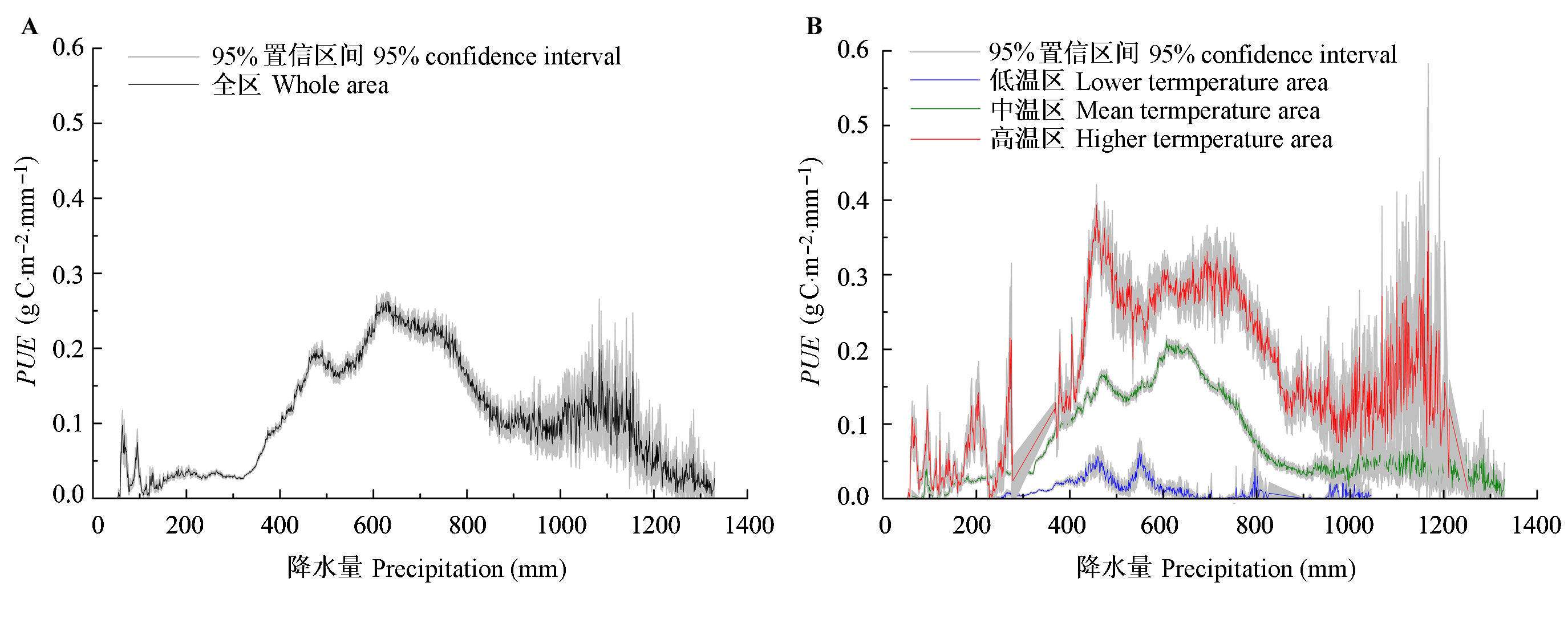
Fig. 4 Change pattern of precipitation use efficiency (PUE) with precipitation in the whole region (A) and different temperature areas (B) in the Qinghai-Xizang Plateau.
| 植被类型 Vegetation type | 面积 Area (×104 km2) | 年降水量 Annual precipitation (mm) | NPP (g C·m-2·a-1) | PUE (g C·m-2·mm-1) | |
|---|---|---|---|---|---|
| 平均值 Mean | 标准偏差 SD | ||||
| 常绿针叶林 ENF | 2.16 | 713.37 | 318.26 | 0.481 | 0.444 |
| 常绿阔叶林 EBF | 6.77 | 753.59 | 352.16 | 0.507 | 0.422 |
| 落叶阔叶林 DBF | 0.21 | 719.68 | 173.93 | 0.255 | 0.206 |
| 草地 Grass | 119.41 | 451.17 | 55.26 | 0.107 | 0.149 |
| 灌丛 Shrub | 33.18 | 481.06 | 56.77 | 0.116 | 0.112 |
| 荒漠 Desert | 22.09 | 218.70 | 0.49 | 0.002 | 0.016 |
| 农田 Cropland | 0.86 | 658.27 | 432.33 | 0.690 | 0.586 |
Table 1 Annual precipitation, net primary production (NPP) and precipitation use efficiency (PUE) for different vegetation distribution regions on the Qinghai-Xizang Plateau from 2000 to 2008
| 植被类型 Vegetation type | 面积 Area (×104 km2) | 年降水量 Annual precipitation (mm) | NPP (g C·m-2·a-1) | PUE (g C·m-2·mm-1) | |
|---|---|---|---|---|---|
| 平均值 Mean | 标准偏差 SD | ||||
| 常绿针叶林 ENF | 2.16 | 713.37 | 318.26 | 0.481 | 0.444 |
| 常绿阔叶林 EBF | 6.77 | 753.59 | 352.16 | 0.507 | 0.422 |
| 落叶阔叶林 DBF | 0.21 | 719.68 | 173.93 | 0.255 | 0.206 |
| 草地 Grass | 119.41 | 451.17 | 55.26 | 0.107 | 0.149 |
| 灌丛 Shrub | 33.18 | 481.06 | 56.77 | 0.116 | 0.112 |
| 荒漠 Desert | 22.09 | 218.70 | 0.49 | 0.002 | 0.016 |
| 农田 Cropland | 0.86 | 658.27 | 432.33 | 0.690 | 0.586 |
| 植被类型 Vegetation type | 面积 Area (×104 km2) | 年降水量 Annual precipitation (mm) | NPP (g C·m-2·a-1) | PUE (g C·m-2·mm-1) | |
|---|---|---|---|---|---|
| 平均值 Mean | 标准偏差 SD | ||||
| 高寒草原 Alpine steppe | 26.47 | 289.75 | 9.42 | 0.033 | 0.046 |
| 高寒荒漠 Alpine desert | 0.63 | 316.54 | 0.80 | 0.003 | 0.012 |
| 高寒草甸 Alpine meadow | 38.96 | 507.62 | 53.98 | 0.100 | 0.103 |
Table 2 Annual precipitation, net primary production (NPP) and precipitation use efficiency (PUE) for the region of main grass type regions on the Qinghai-Xizang Plateau from 2000 to 2008
| 植被类型 Vegetation type | 面积 Area (×104 km2) | 年降水量 Annual precipitation (mm) | NPP (g C·m-2·a-1) | PUE (g C·m-2·mm-1) | |
|---|---|---|---|---|---|
| 平均值 Mean | 标准偏差 SD | ||||
| 高寒草原 Alpine steppe | 26.47 | 289.75 | 9.42 | 0.033 | 0.046 |
| 高寒荒漠 Alpine desert | 0.63 | 316.54 | 0.80 | 0.003 | 0.012 |
| 高寒草甸 Alpine meadow | 38.96 | 507.62 | 53.98 | 0.100 | 0.103 |

Fig. 5 Relationships between precipitation use efficiency (PUE) and air temperature and precipitation in the areas with mean annual precipitation of 300-470 mm (A) and 470-535 mm (B).
| 1 | Austin AT, Vitousek PM (1998). Nutrient dynamics on a precipitation gradient in Hawai’i. Oecologia, 113, 519-529. |
| 2 | Bai YF, Wu JG, Qi X, Pan QM, Huang JH, Yang DL, Han XG ( 2008). Primary production and rain use efficiency across a precipitation gradient on the Mongolia Plateau. Ecology, 89, 2140-2153. |
| 3 | Cao MK, Woodward FI ( 1998a). Net primary and ecosystem production and carbon stocks of terrestrial ecosystems and their response to climatic change. Global Change Biology, 4, 185-198. |
| 4 | Cao MK, Woodward FI ( 1998b). Dynamic responses of terrestrial ecosystem carbon cycling to global climate change. Nature, 393, 249-252. |
| 5 | Cao MK ( 曹明奎), Yu GR ( 于贵瑞), Liu JY ( 刘纪远), Li KR ( 李克让 ) ( 2004). Multi-scale observation and cross-scale mechanistic modeling on terrestrial ecosystem carbon cycle. Science in China Series D: Earth Sciences (中国科学D辑: 地球科学), 48, 17-32. (in Chinese) |
| 6 | Chapin FS, Matson PA, Mooney HA (2002). Principles of Terrestrial Ecosystem Ecology. Translated by Li B (李博), Zhao B (赵斌), Peng RH (彭容豪)( 2005). Higher Education Press, Beijing. (in Chinese) |
| 7 | Fan JW ( 樊江文), Shao QQ ( 邵全琴), Wang JB ( 王军邦), Chen ZQ ( 陈卓奇), Zhong HP ( 钟华平 ) ( 2011). An analysis of temporal-spatial dynamics of grazing pressure on grassland in Three Rivers Headwater Region. Chinese Journal of Grassland (中国草地学报), 33(3), 64-72. (in Chinese with English abstract) |
| 8 | Fan JW, Wang K, Zhong HP, Hu ZM, Han B, Zhang WY, Wang JB ( 2009). Allocation of vegetation biomass across a climate-related gradient in the grasslands of Inner Mongolia. Journal of Arid Environments, 73, 521-528. |
| 9 | Fan JW, Zhong HP, Harris W, Yu GR, Wang SQ, Hu ZM, Yue YZ ( 2008). Carbon storage in the grasslands of China based on field measurements of above- and below-ground biomass. Climatic Change, 86, 375-396. |
| 10 | Fang JY ( 方精云), Liu GH ( 刘国华), Xu SL ( 徐嵩龄 ) ( 1996a). Biomass and net production of forest vegetation in China. Acta Ecologica Sinica (生态学报), 16, 497-508. (in Chinese with English abstract) |
| 11 | Fang JY ( 方精云), Liu GH ( 刘国华), Xu SL ( 徐嵩龄 ) (1996b). Carbon storage in terrestrial ecosystem in China (中国陆地生态系统的碳库). In: Wang GC (王庚辰), Wen YP (温玉璞) eds. The Measurement of Greenhouse Gas and Their Release and Related Processes (温室气体浓度和排放监测及相关过程). Environment Science Press, Beijing. 109-128. (in Chinese) |
| 12 | Feng S ( 冯松), Tang MC ( 汤懋苍), Wang DM ( 王冬梅 ) ( 1998). New evidence of the Tibet Plateau as promoter area of Chinese climate change. Chinese Science Bulletin (科学通报), 43, 633-636. (in Chinese) |
| 13 | Feng ZW ( 冯宗炜), Wang XK ( 王效科), Wu G ( 吴刚 ) ( 1999). Biomass and Productivity of Forest Ecosystem in China (中国森林生态系统的生物量和生产力). Science Press, Beijing. (in Chinese) |
| 14 | Fischer RA, Turner NC ( 1978). Plant productivity in the arid and semiarid zones. Annual Review of Plant Physiology, 29, 277-317. |
| 15 | Halse SA, Scanlon MD, Cocking JS, Smith MJ, Kay WR ( 2007). Factors affecting river health and its assessment over broad geographic ranges: the Western Australian experience. Environmental Monitoring and Assessment, 134, 161-175. |
| 16 | Hutchinson MF ( 2001). Anusplin Version 4.2 User Guide. Centre for Resource and Environmental Studies, Australian National University, Canberra. |
| 17 | Hu ZM, Yu GR, Fan JW, Zhong HP, Wang SQ, Li SG ( 2010). Precipitation-use efficiency along a 4500-km grassland transect. Global Ecology and Biogeography, 19, 842-851. |
| 18 | Hu ZM ( 胡中民), Yu GR ( 于贵瑞), Wang QF ( 王秋凤), Zhao FH ( 赵风华 ) ( 2009). Ecosystem level water use efficiency: a review. Acta Ecologica Sinica (生态学报), 29, 1498-1507. (in Chinese with English abstract) |
| 19 | Huxman TE, Smith MD, Fay PA, Knapp AK, Shaw MR, Loik ME, Smith SD, Tissue DT, Zak JC, Weltzin JF, Pockman WT, Sala OE, Haddad BM, Harte J, Koch GW, Schwinning S, Small EE, Williams DG ( 2004). Convergence across biomes to a common rain-use efficiency. Nature, 429, 651-654. |
| 20 | Lauenroth WK, Burke IC, Paruelo JM ( 2000). Patterns of production and precipitation-use efficiency of winter wheat and native grasslands in the central Great Plains of the United States. Ecosystems, 3, 344-351. |
| 21 | Le Houérou HN ( 1984). Rain use efficiency: a unifying concept in arid-land ecology. Journal of Arid Environments, 7, 213-247. |
| 22 | Lieth H (1975). Modeling the primary production of the world. In: Lieth H, Whittaker RH eds. Primary Productivity of the Biosphere. Springer-Verlag, Berlin. 237-263. |
| 23 | Liu ML ( 刘明亮 ) ( 2001). Land-Use/Land-Cover Change and Terrestrial Ecosystem Phytomass Carbon Pool and Production in China (中国土地利用/土地覆盖变化与陆地生态系统植被碳库和生产力研究). PhD dissertation, Institute of Remote Sensing Applications, Chinese Academy of Sciences, Beijing. (in Chinese with English abstract) |
| 24 | Liu XD, Chen BD ( 2000). Climatic warming in the Tibetan Plateau during recent decades. International Journal of Climatology, 20, 1729-1742. |
| 25 | Liu YH ( 刘勇洪), Niu Z ( 牛铮), Xu YM ( 徐永明), Wang CY ( 王长耀), Li GC ( 李贵才 ) ( 2006). Design of land cover classification system for China and its application research based on MODIS data. Transactions of the Chinese Society of Agricultural Engineering (农业工程学报), 22(5), 99-104. (in Chinese) |
| 26 | Lu L ( 卢玲), Li X ( 李新), Huang CL ( 黄春林 ), Veroustraete F ( 2007). Analysis of the spatio-temporal characteristics of water use efficiency of vegetation in West China. Journal of Glaciology and Geocryology (冰川冻土), 29, 777-784. (in Chinese with English abstract) |
| 27 | Paruelo JM, Lauenroth WK, Burke IC, Sala OE ( 1999). Grassland precipitation-use efficiency varies across a resource gradient. Ecosystems, 2, 64-68. |
| 28 | Prince SD, Goward SN ( 1995). Global primary production: a remote sensing approach. Journal of Biogeography, 22, 815-835. |
| 29 | Rosenzweig ML ( 1968). Net primary productivity of terrestrial communities: prediction from climatological data. The American Naturalist, 102, 67-74. |
| 30 | Sala OE, Parton WJ, Joyce LA, Lauenroth WK ( 1988). Primary production of the central grassland region of the United States. Ecology, 69, 40-45. |
| 31 | Tang MC ( 汤懋苍), Li CQ ( 李存强 ) (1992). Evidence analysis on the Tibet Plateau as promoter area of Chinese climate change. In: The China Society on Tibet Plateau (中国青藏高原研究会) eds. Proceedings of the 1st International Symposium on the Tibetan Plateau (中国青藏高原研究会第一届学术论文会论文选). Sciences Press, Beijing. 42-48. (in Chinese) |
| 32 | Wang JB, Liu JY, Cao MK, Liu YF, Yu GR, Li GC, Qi SH, Li KR ( 2011). Modelling carbon fluxes of different forests by coupling a remote-sensing model with an ecosystem process model. International Journal of Remote Sensing, 32, 6539-6567. |
| 33 | Wang JB ( 王军邦), Liu JY ( 刘纪远), Shao QQ ( 邵全琴), Liu RG ( 刘荣高), Fan JW ( 樊江文), Chen ZQ ( 陈卓奇 ) ( 2009). Spatial-temporal patterns of net primary productivity for 1988-2004 based on GLOPEM-CEVSA model in the “Three-river Headwaters” region of Qinghai Pro- vince, China. Chinese Journal of Plant Ecology (植物生态学报), 33, 254-269. (in Chinese with English abstract) |
| 34 | Wang Y ( 王英), Cao MK ( 曹明奎), Tao B ( 陶波), Li KR ( 李克让 ) ( 2006). The characteristics of spatio-temporal patterns in precipitation in China under the background of global climate change. Geographical Research (地理研究), 25, 1031-1041. (in Chinese with English abstract) |
| 35 | Yang YH, Fang JY, Fay PA, Bell JE, Ji CJ ( 2010). Rain use efficiency across a precipitation gradient on the Tibetan Plateau. Geophysical Research Letters, 37, L15702. |
| 36 | Yao TD ( 姚檀栋), Zhu LP ( 朱立平 ) ( 2006). The response of environmental changes on Tibetan Plateau to global changes and adaptation strategy. Advances in Earth Science (地球科学进展), 21, 459-464. (in Chinese with English abstract) |
| 37 | Yu GR ( 于贵瑞 ) (2009). Scientific Frontier on Human Activities and Ecosystem Changes (人类活动与生态系统变化的前沿科学问题). Higher Education Press, Beijing. (in Chinese) |
| 38 | Yu GR, Song X, Wang QF, Liu YF, Guan DX, Yan JH, Sun XM, Zhang LM, Wen XF ( 2008). Water use efficiency of forest ecosystems in eastern China and its relations to climatic variables. New Phytologist, 177, 927-937. |
| 39 | Yu GR ( 于贵瑞), Wang QF ( 王秋凤 ) (2010). Ecophysiology of Plant Photosynthesis, Transpiration, and Water Use (植物光合、蒸腾与水分利用的生理生态学). Science Press, Beijing. (in Chinese) |
| 40 | Zhao J ( 赵济), Chen CK ( 陈传康 ) (1999). Geography of China (中国地理). Higher Education Press, Beijing. (in Chinese) |
| 41 | Zheng D ( 郑度), Li BY ( 李炳元 ) ( 1999). Progress in studies on geographical environments of the Qinghai-Xizang Plateau. Scientia Geographica Sinica (地理科学), 9, 289-296. (in Chinese with English abstract) |
| [1] | WANG Yu-Xian, HOU Meng, XIE Yan-Yan, LIU Zuo-Jun, ZHAO Zhi-Gang, LU Ning-Na. Relationships of flower longevity with attractiveness traits and their effects on female fitness of alpine meadow plants on the Qinghai-Xizang Plateau, China [J]. Chin J Plant Ecol, 2020, 44(9): 905-915. |
| [2] | LI Xue-Ying, ZHU Wen-Quan, LI Pei-Xian, XIE Zhi-Ying, ZHAO Cen-Liang. Predicting phenology shifts of herbaceous plants on the Qinghai-Xizang Plateau under climate warming with the space-for-time method [J]. Chin J Plant Ecol, 2020, 44(7): 742-751. |
| [3] | ZHANG Chan, AN Yu-Meng, Yun JÄSCHKE, WANG Lin-Lin, ZHOU Zhi-Li, WANG Li-Ping, YANG Yong-Ping, DUAN Yuan-Wen. Processes on reproductive ecology of plant species in the Qinghai-Xizang Plateau and adjacent highlands [J]. Chin J Plant Ecol, 2020, 44(1): 1-21. |
| [4] | CAI Qin, DING Jun-Xiang, ZHANG Zi-Liang, HU Jun, WANG Qi-Tong, YIN Ming-Zhen, LIU Qing, YIN Hua-Jun. Distribution patterns and driving factors of leaf C, N and P stoichiometry of coniferous species on the eastern Qinghai-Xizang Plateau, China [J]. Chin J Plant Ecol, 2019, 43(12): 1048-1060. |
| [5] | MOU Jing, BIN Zhen-Jun, LI Qiu-Xia, BU Hai-Yan, ZHANG Ren-Yi, XU Dang-Hui. Effects of nitrogen and silicon addition on soil nitrogen mineralization in alpine meadows of Qinghai-Xizang Plateau [J]. Chin J Plant Ecol, 2019, 43(1): 77-84. |
| [6] | ZHANG Yun, YIN Ding-Cai, TIAN Kun, ZHANG Wei-Guo, HE Rong-Hua, HE Wen-Qing, SUN Jiang-Mei, LIU Zhen-Ya. Radial growth responses of Picea likiangensis to climate variabilities at different altitudes in Yulong Snow Mountain, southwest China [J]. Chin J Plant Ecol, 2018, 42(6): 629-639. |
| [7] | ZHOU Tong, CAO Ru-Yin, WANG Shao-Peng, CHEN Jin, TANG Yan-Hong. Responses of green-up dates of grasslands in China and woody plants in Europe to air temperature and precipitation: Empirical evidences based on survival analysis [J]. Chin J Plant Ecol, 2018, 42(5): 526-538. |
| [8] | GENG Xiao-Dong, Xu Ri, LIU Yong-Wen. Responses of ecosystem carbon exchange to multi-level water addition in an alpine meadow in Namtso of Qinghai-Xizang Plateau, China [J]. Chin J Plant Ecol, 2018, 42(3): 397-405. |
| [9] | SHI Guo-Xi, WANG Wen-Ying, JIANG Sheng-Jing, CHENG Gang, YAO Bu-Qing, FENG Hu-Yuan, ZHOU Hua-Kun. Effects of the spreading of Ligularia virgaurea on soil physicochemical property and microbial functional diversity [J]. Chin J Plant Ecol, 2018, 42(1): 126-132. |
| [10] | GOU Xiao-Lin, ZHOU Qing-Ping, CHEN You-Jun, WEI Xiao-Xing, TU Wei-Guo. Characteristics of nutrients in two dominant plant species and rhizospheric soils in alpine desert of the Qinghai-Xizang Plateau under contrasting climates [J]. Chin J Plan Ecolo, 2018, 42(1): 133-142. |
| [11] | CHAI Xi, LI Ying-Nian, DUAN Cheng, ZHANG Tao, ZONG Ning, SHI Pei-Li, HE Yong-Tao, ZHANG Xian-Zhou. CO2 flux dynamics and its limiting factors in the alpine shrub-meadow and steppe-meadow on the Qinghai-Xizang Plateau [J]. Chin J Plant Ecol, 2018, 42(1): 6-19. |
| [12] | WANG Jun, WANG Guan-Qin, LI Fei, PENG Yun-Feng, YANG Gui-Biao, YU Jian-Chun, ZHOU Guo-Ying, YANG Yuan-He. Effects of short-term experimental warming on soil microbes in a typical alpine steppe [J]. Chin J Plan Ecolo, 2018, 42(1): 116-125. |
| [13] | Yang WANG, Lin-Lin MIAO, Dan YU, Chun-Hua LIU, Zhong WANG. Effects of environmental factors on gross caloric values of three life-forms aquatic plants on the Qinghai-Xizang Plateau, China [J]. Chin J Plant Ecol, 2017, 41(2): 209-218. |
| [14] | He-Liang HE, Xiao-Cheng YANG, Dan-Dan LI, Chun-Ying YIN, Yun-Xiang LI, Guo-Ying ZHOU, Lin ZHANG, Qing LIU. Stoichiometric characteristics of carbon, nitrogen and phosphorus of Sibiraea angustata shrub on the eastern Qinghai-Xizang Plateau [J]. Chin J Plant Ecol, 2017, 41(1): 126-135. |
| [15] | Jian WANG, Gen-Xu WANG, Chang-Ting WANG, Fei RAN, Rui-Ying CHANG. Carbon storage and potentials of the broad-leaved forest in alpine region of the Qinghai- Xizang Plateau, China [J]. Chin J Plant Ecol, 2016, 40(4): 374-384. |
| Viewed | ||||||
|
Full text |
|
|||||
|
Abstract |
|
|||||
Copyright © 2022 Chinese Journal of Plant Ecology
Tel: 010-62836134, 62836138, E-mail: apes@ibcas.ac.cn, cjpe@ibcas.ac.cn