
Chin J Plant Ecol ›› 2005, Vol. 29 ›› Issue (2): 185-196.DOI: 10.17521/cjpe.2005.0024
• Original article • Previous Articles Next Articles
LI Xiao-Bing, CHEN Yun-Hao*( ), YU Hong-Jing
Received:2003-12-29
Accepted:2004-05-15
Online:2005-12-29
Published:2005-03-10
Contact:
CHEN Yun-Hao
LI Xiao-Bing, CHEN Yun-Hao, YU Hong-Jing. PRINCIPLES, METHODOLOGIES AND APPLICATION OF REMOTELY SENSED DATA FOR DEVELOPING LAND COVER CHARACTERISTICS DATA SET FOR NECT[J]. Chin J Plant Ecol, 2005, 29(2): 185-196.
Add to citation manager EndNote|Ris|BibTeX
URL: https://www.plant-ecology.com/EN/10.17521/cjpe.2005.0024
| 基本数据类型 Basic data types | 详细内容 Details |
|---|---|
| 土地利用/覆盖变化数据 Data of land use and land cover change | 各 类土地利用/覆盖动态的信息, 包括城市、工业、干旱区与灌溉农业、半天然与天然森林、草地、裸地等自然区域以及保护区等, 还包括通过历史数据推演出来的历史上的LUCC动态信息 Information of land use and land cover change, including natural region and conservation such as cities, industry, arid region, irrigated farming, semi-natural forest and natural forest, grassland, bare soil, and so on, also including historic dynamic information of land use and land cover change through extrapolating historic data |
| 环境数据 Environmental data | 气候数据 (降水、温度、光照、相对湿度等) Climate data (precipitation, temperature, solar irradiation, relative humidity, and so on) |
| 地形数据 (海拔、坡度与方位) Terrain data (altitude, slope, orientation) | |
| 土壤数据 (土壤有机碳、肥力、组织等) Soil data (soil organic carbon, soil fertility, soil fabric, and so on) | |
| 植被数据 (植被盖度、种类、动态) Vegetation data (vegetation fraction, species, dynamics) | |
| 养分传输 Nutrient transmission | |
| 土地资源退化 Land resource degradation | |
| 水资源退化与污染 (地表水与地下水) Water resource degradation and pollution (surface water and ground water) | |
| 经济数据 Economic data | 多部门生产结构 (地区水平上) Multi-section productive structure (region-level) |
| 生 产投入 (技术、农业化肥、劳动力、机械、灌溉等的投入, 在地区水平上) Productive input (input of technology, agriculture fertilizer, labor force, mechanism, irrigation, and so on, in region-level) | |
| 价格、补贴与税收 (省或国家水平上) Price, subsidies and revenue (province-level or country-level) | |
| 基础设施 (能源、交通与电信) Foundation establishment (energy sources, traffic and telecom) | |
| 社会数据 Social data | 人口普查数据与空间分布模式 (地区水平上) Census data and distribution 收入分配 (地区水平上) Income distribution (region-level) |
| 迁移 (国际间与省之间) Transference (international and provincial) | |
| 制度 (土地占有权、水权等) Regime (soil possess rights, water rights) | |
| 健康 (实际/潜在性疾病发生率的地区分布) Health (area distribution of actual/potential disease occur rate) | |
| 全球与区域尺度上LUCC驱动力数据 Driving force data of LUCC in global and regional scale | 人口增长、人口结构与迁移的变化 Change of population increasing, population structure and transference |
| 能源、产品与舒适的追求 (消费模式、游憩) Pursue of energy sources, products and comfort (consumption pattern, relaxation) | |
| 生活方式与城乡间的相互关系 Interrelation of lifestyle with urban and rural | |
| 自然条件中的极端事件与变化性 Extreme event under natural condition and variability | |
| 宏观经济驱动力 Macro-economy driving force | |
| 国家政策措施与指令 Country policy and injunction | |
| 外部驱动力 (贸易全球化、国际协定) Exterior driving force (commercial globalization, international trade) |
Table 1 Basic data demanded for research on land use and land cover change
| 基本数据类型 Basic data types | 详细内容 Details |
|---|---|
| 土地利用/覆盖变化数据 Data of land use and land cover change | 各 类土地利用/覆盖动态的信息, 包括城市、工业、干旱区与灌溉农业、半天然与天然森林、草地、裸地等自然区域以及保护区等, 还包括通过历史数据推演出来的历史上的LUCC动态信息 Information of land use and land cover change, including natural region and conservation such as cities, industry, arid region, irrigated farming, semi-natural forest and natural forest, grassland, bare soil, and so on, also including historic dynamic information of land use and land cover change through extrapolating historic data |
| 环境数据 Environmental data | 气候数据 (降水、温度、光照、相对湿度等) Climate data (precipitation, temperature, solar irradiation, relative humidity, and so on) |
| 地形数据 (海拔、坡度与方位) Terrain data (altitude, slope, orientation) | |
| 土壤数据 (土壤有机碳、肥力、组织等) Soil data (soil organic carbon, soil fertility, soil fabric, and so on) | |
| 植被数据 (植被盖度、种类、动态) Vegetation data (vegetation fraction, species, dynamics) | |
| 养分传输 Nutrient transmission | |
| 土地资源退化 Land resource degradation | |
| 水资源退化与污染 (地表水与地下水) Water resource degradation and pollution (surface water and ground water) | |
| 经济数据 Economic data | 多部门生产结构 (地区水平上) Multi-section productive structure (region-level) |
| 生 产投入 (技术、农业化肥、劳动力、机械、灌溉等的投入, 在地区水平上) Productive input (input of technology, agriculture fertilizer, labor force, mechanism, irrigation, and so on, in region-level) | |
| 价格、补贴与税收 (省或国家水平上) Price, subsidies and revenue (province-level or country-level) | |
| 基础设施 (能源、交通与电信) Foundation establishment (energy sources, traffic and telecom) | |
| 社会数据 Social data | 人口普查数据与空间分布模式 (地区水平上) Census data and distribution 收入分配 (地区水平上) Income distribution (region-level) |
| 迁移 (国际间与省之间) Transference (international and provincial) | |
| 制度 (土地占有权、水权等) Regime (soil possess rights, water rights) | |
| 健康 (实际/潜在性疾病发生率的地区分布) Health (area distribution of actual/potential disease occur rate) | |
| 全球与区域尺度上LUCC驱动力数据 Driving force data of LUCC in global and regional scale | 人口增长、人口结构与迁移的变化 Change of population increasing, population structure and transference |
| 能源、产品与舒适的追求 (消费模式、游憩) Pursue of energy sources, products and comfort (consumption pattern, relaxation) | |
| 生活方式与城乡间的相互关系 Interrelation of lifestyle with urban and rural | |
| 自然条件中的极端事件与变化性 Extreme event under natural condition and variability | |
| 宏观经济驱动力 Macro-economy driving force | |
| 国家政策措施与指令 Country policy and injunction | |
| 外部驱动力 (贸易全球化、国际协定) Exterior driving force (commercial globalization, international trade) |
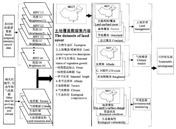
Fig.1 Diagram of land cover characteristics data set and its application ways of NECT (Modified from Loveland et al. 1991)
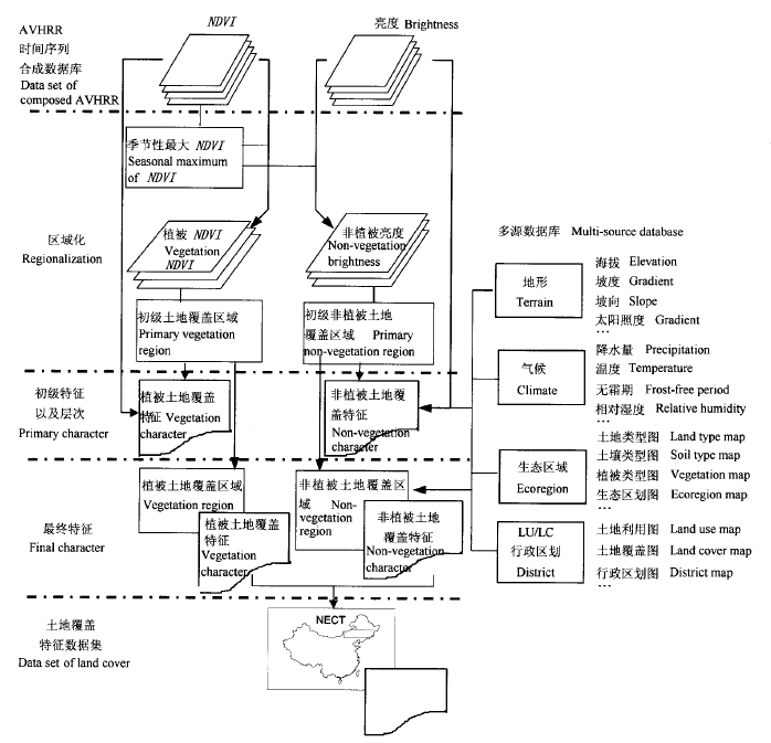
Fig.2 Processing flow for developing the land cover characteristics data set in NECT (Modified from Loveland et al. 1991)
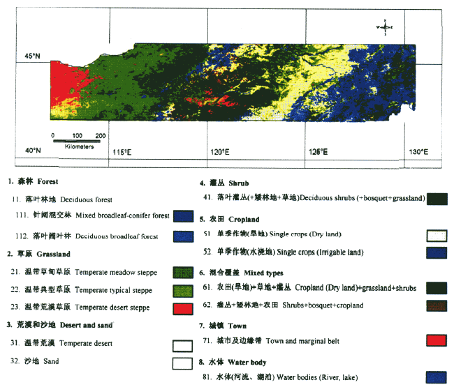
Fig.3 Land cover map of NECT
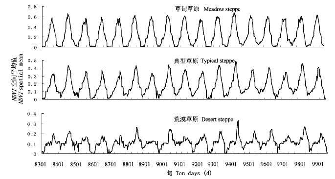
Fig.4 Seasonal NDVI rhythm (ten-day) from 1983 to 1999
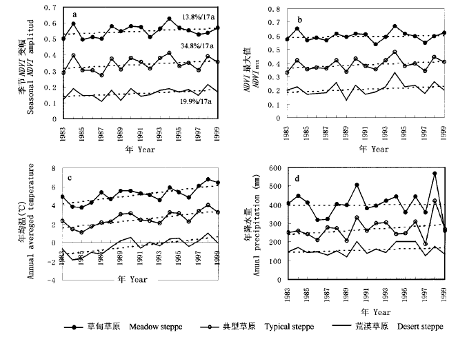
Fig.5 Seasonal NDVI amplitude (a), annual NDVImax (b), annual averaged temperature (c) and annual precipitation variation (d) from 1983 to 1999 Broken lines present trend in the figure
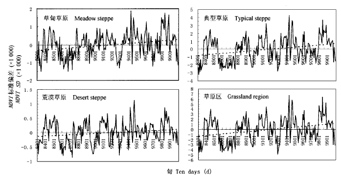
Fig.6 Time series of spatial sums of 10-day NDVI standard deviation
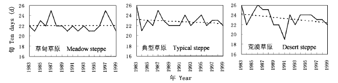
Fig.7 Change of NDVImax outset timing from 1983 to 1999
| [1] |
Cihlar J (2000). Land cover mapping of large areas from satellites: status and research priorities. International Journal of Remote Sensing, 21,1093-1114.
DOI URL |
| [2] |
Cihlar J, St-Laurent L, Dyer JA (1991). Relationship between the Normalized Difference Vegetation Index (NDVI) and ecological variables. Remote Sensing of Environment, 35,279-298.
DOI URL |
| [3] |
DeFries KL, Townshend JRG (1994). NDVI-derived land cover classification at global scales. International Journal of Remote Sensing, 15,3567-3586.
DOI URL |
| [4] |
DeFries RS, Hansen MC, Townshend JRG, Sohlberg RS (1998). Global land cover classification at 8 km spatial resolution: the use of training data derived from Landsat imagery in decision tree classifiers. International Journal of Remote Sensing, 19,3141-3168.
DOI URL |
| [5] | Eastman JR, Fulk M (1993). Long time series evaluation using standardized principal components. Photogrammetric Engineering and Remote Sensing, 59,991-996. |
| [6] |
Eidenshink JC, Faundeen JL (1986). The 1-km AVHRR global land data set: first stages in implementation. International Journal of Remote Sensing, 7,1417-1434.
DOI URL |
| [7] |
Eklundh L (1998). Estimating relations between AVHRR NDVI and rainfall in East Africa at 10-day and monthly time scale. International Journal of Remote Sensing, 19,563-568.
DOI URL |
| [8] |
Fennessy MJ, Xue Y (1997). Impact on USGS vegetation map on GCM simulations over the United States. Ecological Applications, 7,22-23.
DOI URL |
| [9] | Fung T, LaDrew E (1987). Application of principal components analysis to change detection. Photogrammetric Engineering and Remote Sensing, 53,1649-1658. |
| [10] |
Hansen MC, Reed B (2000). A comparison of the IGBP DISCover and University of Maryland 1 km global land cover products. International Journal of Remote Sensing, 21,1365-1373.
DOI URL |
| [11] | Henderson-Sellers A, Wilson MF, Thomas G, Dickinson RE (1986). Current Global Land-Surface Data Sets for Use in Climate-Related Studies: NCAR Technical Note+STR. Boulder, Colorado, 110. |
| [12] |
Holben BN (1986). Characteristic of maximum-value composite images from temporal AVHRR data. International Journal of Remote Sensing, 15,3443-3462.
DOI URL |
| [13] | IGBP (1990). Global Change, Report No.12. Stockholm, Sweden. |
| [14] |
James ME, Kalluri SNV (1994). The Pathfinder AVHRR land data set: an improved coarse resolution data set for terrestrial monitoring. International Journal of Remote Sensing, 15,3347-3363.
DOI URL |
| [15] |
Keeling CD, Whorf TP, Whalen M, van der Plicht J (1995). Interannual extremes in the rise of atmospheric carbon dioxide since 1980. Nature, 375,666-667.
DOI URL |
| [16] |
Lambin EF, Ehrlich D (1997). Land-cover changes in Sub-Saharan Africa (1982-1991): application of a change index based on remotely sensed surface temperature and vegetation indices at a continental scale. Remote Sensing of Environment, 61,181-200.
DOI URL |
| [17] |
Lark RM (1995). Contribution of principal components to discrimination of classes of land cover in multi-spectral imagery. International Journal of Remote Sensing, 16,779-787.
DOI URL |
| [18] | Li XB (李晓兵) (1997). Application of NOAA-AVHRR data on study of land cover change. Earth Science Frontiers (地学前缘), 4 (1-2), 16. (in Chinese with English abstract) |
| [19] |
Li XB (李晓兵), Chen YH (陈云浩), Li X (李霞) (2003). Study on regional land cover patterns derived from multi-scale remotely sensed data. Acta Phytoecologica Sinica (植物生态学报), 27,577-586. (in Chinese with English abstract)
DOI |
| [20] | Li XB (李晓兵), Shi PJ (史培军) (1999). Research on regulation of NDVI change of Chinese primary vegetation types based on NOAA/AVHRR data. Acta Botanica Sinica (植物学报), 41,314-324. (in Chinese with English abstract) |
| [21] |
Lloyd D (1991). A phonological classification of terrestrial vegetation using shortwave vegetation index imagery. International Journal of Remote Sensing, 11,2269-2279.
DOI URL |
| [22] |
Loveland TR, Belward AS (1997). The IGBP-DIS global 1 km land cover dataset, DISCover: first results. International Journal of Remote Sensing, 18,3289-3295.
DOI URL |
| [23] | Loveland TR, Merchant JW, Brown JF, Ohlen DO, Reed BC, Olson P, Hutchinson J (1995). Seasonal land-cover regions of the United States. Annals of Association of American Geographer, 82,339-355. |
| [24] | Loveland TR, Merchant JW, Ohlen DO, Brown JF (1991). Development of a land-cover characteristics database for the conterminous U. S. Photogrammetric Engineering and Remote Sensing, 57,1453-1463. |
| [25] |
Loveland TR, Reed BC, Brown JF, Ohlen DO, Zhu Z, Yang L, Merchant JW (2000). Development of a global land cover characteristics database and IGBP DISCover from 1km AVHRR data. International Journal of Remote Sensing, 21,1303-1330.
DOI URL |
| [26] | Mynenl RB, Keeling CD, Tucker CJ, Asrar G Nemani, RR (1997). Increased plant growth in the northern high latitudes from 1981 to 1991. Nature, 386,698-702. |
| [27] |
Pan YZ, Li XB, Gong P, He CY, Shi PJ, Pu RL (2003). An integrative classification of vegetation in China based on NOAA/AVHRR and vegetation-climate indices of the holdridge life zone. International Journal of Remote Sensing, 24,1009-1027.
DOI URL |
| [28] |
Reed BC, Brown JF, VanderZee D, Loveland TR, Merchant JW, Ohlen DO (1994). Measuring phenological variability from satellite imagery. Journal of Vegetation Science, 5,703-714.
DOI URL |
| [29] |
Running SW, Loveland TR (1995). A remote sensing based vegetation classification logic for global land cover analysis. Remote Sensing of Environment, 51,39-48.
DOI URL |
| [30] |
Townshend JRG (1994). Global data sets for land applications from the Advance Very High Resolution Radiometer: an introduction. International Journal of Remote Sensing, 15,3319-3332.
DOI URL |
| [31] |
Townshend JRG, Justice CO, Kalb V (1987). Characterization and classification of South American land cover types using satellite data. International Journal of Remote Sensing, 7,1395-1416.
DOI URL |
| [32] |
Turker CJ, Townshend JRG, Goff TE (1985). African land-cover classification using satellite data. Science, 227,369-375.
DOI URL |
| [33] | Zhang XS (张新时) (1989). The potential evapotranspiration (PE) index for vegetation and vegetation-climatic classification (Ⅱ) — an introduction of main methods and PEP program. Acta Phytoecologica Sinica (植物生态学报), 13,197-207. (in Chinese with English abstract) |
| [34] | Zhang XS (张新时), Gao Q (高琼), Yang DA (杨奠安), Zhou GS (周广胜), Ni J (倪健), Wang Q (王权) (1997). A gradient analysis and prediction on the northeast China transect (NECT) for global change study. Acta Botanica Sinica (植物学报), 39,785-799. (in Chinese with English abstract) |
| [35] | Zhou GS (周广胜) (2002). NECT and Global Change (NECT与全球变化). Meteorological Press, Beijing. (in Chinese) |
| [1] | YANG Ming-Wei, JIN Xiao-Fang. Diversity and evolutionary ecology of nectar spurs in angiosperms [J]. Chin J Plant Ecol, 2023, 47(9): 1193-1210. |
| [2] | Edith BAI, XUE Bing. A review of influences of land use and land cover change on ecosystems [J]. Chin J Plant Ecol, 2020, 44(5): 543-552. |
| [3] | Chao LI, Shu-Qing ZHAO, Jing-Yun FANG. Vegetation cover change and driving factors in Fujian Province between 1975 and 2014 [J]. Chin J Plan Ecolo, 2017, 41(2): 157-164. |
| [4] | ZHANG Feng, ZHOU Guang-Sheng. SPATIAL-TEMPORAL VARIATIONS IN NET PRIMARY PRODUCTIVITY ALONG NORTHEAST CHINA TRANSECT (NECT) FROM 1982 TO 1999 [J]. Chin J Plant Ecol, 2008, 32(4): 798-809. |
| [5] | ZHOU Rui, HU Yu-Zhe, XIONG Ying, WANG Hui, GE Jian-Ping, BI Xiao-Li. INTERPRETING ECOLOGICAL LAND COVER PATTERN FOR THE RIPARIAN ZONE OF THE UPPER MINJIANG RIVER, CHINA [J]. Chin J Plant Ecol, 2007, 31(1): 2-10. |
| [6] | ZHANG Yan-Wen, WANG Yong, GUO You-Hao. THE EFFECTS OF NECTAR ROBBING ON PLANT REPRODUCTION AND EVOLUTION [J]. Chin J Plant Ecol, 2006, 30(4): 695-702. |
| [7] | WU Xiao_Pu, TANG Zhi_Yao, CUI Hai_Ting, FANG Jing_Yun. LAND COVER DYNAMICS OF DIFFERENT TOPOGRAPHIC CONDITIONS IN BEIJING [J]. Chin J Plant Ecol, 2006, 30(2): 239-251. |
| [8] | HONG Jun, GE Jian-Ping, CAI Ti-Jiu, NIE Yi-Huang. LAND COVER CLASSIFICATION OF REMOTELY SENSED IMAGERY USING A METHOD BASED ON TOPOGRAPHICAL RESTRICTIVE FEATURES: A CASE STUDY OF THE JINHE WATERSHED [J]. Chin J Plant Ecol, 2005, 29(6): 927-933. |
| [9] | YU Feng, LI Xiao-Bing, WANG Hong, YU Hong-Jing, CHEN Yun-Hao. LAND COVER CLASSIFICATION IN CHINA BASED ON THE NDVI-T<sub>S</sub> FEATURE SPACE [J]. Chin J Plant Ecol, 2005, 29(6): 934-944. |
| [10] | DENG Xiao-Bao, REN Pan-Yu, LI Qing-Jun. NECTAR SECRETION PATTERNS, FLORAL VISITOR BEHAVIOR AND THEIR IMPACTS ON FRUIT AND SEED SIRE OF ALPINIA BLEPHAROCALYX [J]. Chin J Plant Ecol, 2005, 29(2): 274-280. |
| [11] | WANG Shu-Ping, ZHOU Guang-Sheng, GAO Su-Hua, GUO Jian-Ping. Distribution of Soil Labile Carbon Along the Northeast China Transect (NECT) and Its Response to Climatic Change [J]. Chin J Plan Ecolo, 2003, 27(6): 780-786. |
| [12] | LI Xiao-Bing, CHEN Yun-Hao, Li Xia. Study on Regional Land Cover Patterns Derived From Multi-Scale Remotely Sensed Data [J]. Chin J Plan Ecolo, 2003, 27(5): 577-586. |
| [13] | DENG Xian-Lan, LIU Yu-Cheng, WU Yang. Interconnection Among Dominant Plant Populations of Castanopsis Community in Jinggang Mountain Nature Reserve [J]. Chin J Plan Ecolo, 2003, 27(4): 531-536. |
| [14] | WANG Shu-Ping, ZHOU Guang-Sheng, LU Yu-Cai, ZOU Jian-Jun. Distribution of Soil Carbon, Nitrogen and Phosphorus Along Northeast China Transect (NECT) and Their Relationships with Climatic Factors [J]. Chin J Plan Ecolo, 2002, 26(5): 513-517. |
| [15] | YANG Jian, CHI Hong-Kang, MO Mo. Vegetation Classification of Multispectral Remotely Sensed Data Using Neural Network [J]. Chin J Plan Ecolo, 2002, 26(2): 185-188. |
| Viewed | ||||||
|
Full text |
|
|||||
|
Abstract |
|
|||||
Copyright © 2022 Chinese Journal of Plant Ecology
Tel: 010-62836134, 62836138, E-mail: apes@ibcas.ac.cn, cjpe@ibcas.ac.cn