植物生态学报 ›› 2006, Vol. 30 ›› Issue (4): 571-575.DOI: 10.17521/cjpe.2006.0075

• 论文 • 上一篇    下一篇

植物种群空间分布格局测定的新方法:摄影定位法

王鑫厅1,2, 王炜1,*(), 刘佳慧1, 梁存柱1, 张韬3   

  1. 1 内蒙古大学生态与环境科学系,呼和浩特 010021
    2 内蒙古工业大学能源与动力工程学院环境工程系,呼和浩特 010051
    3 内蒙古农业大学林学院,呼和浩特 010019
  • 收稿日期:2005-08-22 接受日期:2005-12-20 出版日期:2006-08-22 发布日期:2006-07-30
  • 通讯作者: 王炜
  • 作者简介:*E-mail:weiwangww@sina.com
  • 基金资助:
    国家自然科学基金项目(30330120);国家自然科学基金项目(30360016)

A NEW METHOD MEASURING PLANT POPULATION SPATAL PATTERNS: PHOTOGRAPHY ORIENTATION

WANG Xin-Ting1,2, WANG Wei1,*(), LIU Jia-Hui1, LIANG Cun-Zhu1, ZHANG Tao3   

  1. 1 Department of Ecology and Environment Sciences, Inner Mongolia University, Huhhot 010021, China
    2 Department of Environment Engineering, School of Energy and Power Engineering, Inner Mongolia University of Technology, Huhhot 010051, China
    3 Forestry College, Inner Mongolia Agricultural University, Huhhot 010019, China
  • Received:2005-08-22 Accepted:2005-12-20 Online:2006-08-22 Published:2006-07-30
  • Contact: WANG Wei

摘要:

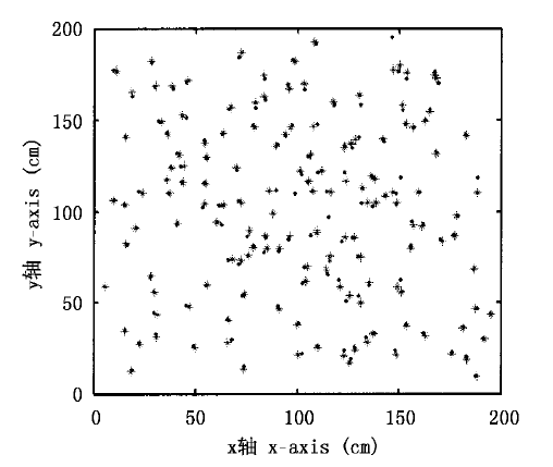
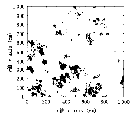
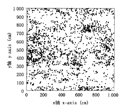
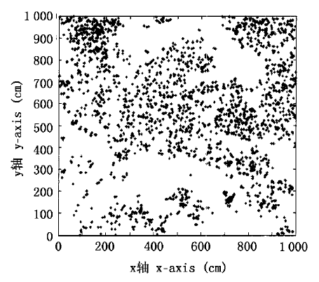
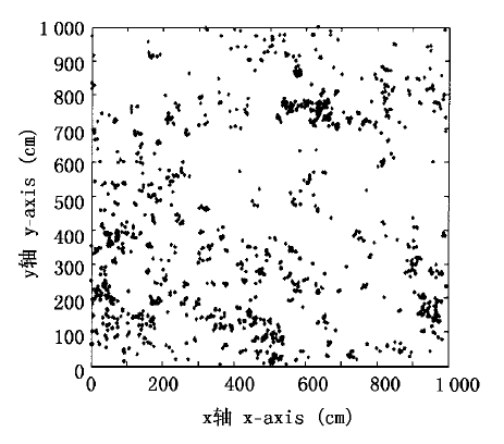
在种群空间分布格局研究中,取样方法至关重要。受点格局分析方法及地理信息系统原理与方法的启示,该文论述了一种新的测定方法:摄影定位法,即在典型草原恢复样地中选取10 m×10 m的群落片段,用竹签将其分成400个50 cm×50 cm的亚样方,应用摄影技术将这400个亚样方内所有的物体按一定的顺序拍摄下来,借助地理信息系统技术准确地确定每株(丛)植物的着生点位置,实现种群格局的测定,并通过威尔柯克森符号秩检验,表明该种方法可行。在使用此方法进行种群格局测定时,工作效率大幅度提高,且在典型草原群落种群格局测定中得到很好的效果。应用该测定方法对种群格局进行动态监测,不仅可以测定每个种群的格局动态变化过程,而且可以监测每株植物的生死过程以及种间的相互关系,进而从种群格局角度去认识演替过程,从而把演替的群落、种群尺度监测细化到个体水平。

关键词: 摄影定位法, 测定方法, 摄影技术, 地理信息系统, 种群格局

Abstract:

Background and Aims Sampling methods were essential in the process of studying plant population spatial distribution patterns. In early time, the population pattern research method which the ecologist used was generally simple. Some comprehensive research examples indicated the transect methods could not clearly present the spatial pattern in the vision. As a result of the spatial pattern complexity, there have not a measuring method to be possible clearly to express its complete characteristic or all information. So the authors presented a new method, photography orientation method, which based on point pattern analysis and GIS.
Methods The research was taken in a fenced plot of degraded typical steppe in the Xilingole League, Inner Mongolia, which had been monitored since 1983 by the Inner Mongolia Grassland Ecosystem Research Station of the Chinese Academy of Sciences. In this research, a community block of 10 m × 10 m was chosen and divided into four hundreds of 50 cm × 50 cm sub-blocks with bamboo chopsticks. All plants in the 400 sub-blocks were then pictured by a digital camera (Nikon D100) in order, and the growing positions of each plant individuals were accurately fixed in the pictures of sub-blocks by using GIS. The feasibility of this new method was examined by Wilcoxon signed ranks test.
Key Results The results showed the method was practicable. The working efficiency was largely enhanced and the research work could be done more delicately when the method was applied to measure population patterns of degraded typical steppe.
Conclusions This study suggests that using this method, the changes in population patterns, the life histories of plant individuals, and the interactions among species could be monitored dynamically; therefore the process of community succession could be probed from the aspect of population patterns.

Key words: Photography orientation method, Camera work, GIS, Population pattern