《中国植被志》研编内容与规范
王国宏1,*( ),方精云1,2,郭柯1,谢宗强1,唐志尧2,沈泽昊2,王仁卿3,王襄平4,王德利5,强胜6,于丹7,彭少麟8,达良俊9,刘庆10,梁存柱11
),方精云1,2,郭柯1,谢宗强1,唐志尧2,沈泽昊2,王仁卿3,王襄平4,王德利5,强胜6,于丹7,彭少麟8,达良俊9,刘庆10,梁存柱11
Contents and protocols for the classification and description of Vegetation Formations, Alliances and Associations of vegetation of China
WANG Guo-Hong1,*(),FANG Jing-Yun1,2,GUO Ke1,XIE Zong-Qiang1,TANG Zhi-Yao2,SHEN Ze-Hao2,WANG Ren-Qing3,WANG Xiang-Ping4,WANG De-Li5,QIANG Sheng6,YU Dan7,PENG Shao-Lin8,DA Liang-Jun9,LIU Qing10,LIANG Cun-Zhu11
),FANG Jing-Yun1,2,GUO Ke1,XIE Zong-Qiang1,TANG Zhi-Yao2,SHEN Ze-Hao2,WANG Ren-Qing3,WANG Xiang-Ping4,WANG De-Li5,QIANG Sheng6,YU Dan7,PENG Shao-Lin8,DA Liang-Jun9,LIU Qing10,LIANG Cun-Zhu11
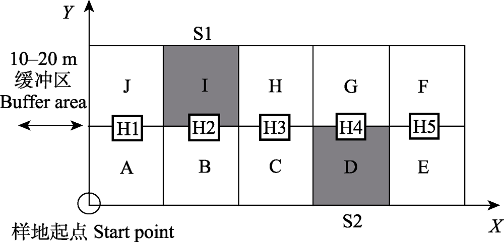
图2. 森林群落样方的设置和样格编号方法, 以20 m × 50 m样方为例, 每个样方由10个10 m × 10 m的样格组成, A-J为样格编号, S1和S2 (阴影部分)为灌木层调查样格; H1-H5为草本层调查小样方(1 m × 1 m)。样方四边应各留10-20 m的缓冲区(
Fig. 2. Plot setting and quadrate coding for forest communities. The 20 m × 50 m plot is composed of 10 quadrates (A-J), each with an area of 10 m × 10 m. The shadowed quadrates (S1 and S2) are selected for shrub layer investigation, and subplots (H1-H5, 1 m × 1 m) are selected for herbaceous layer investigation. A buffer zone of 10-20 m at each side of the plot is necessary to keep the plot away from apparent human activities. Modified from