卫星遥感监测产品在中国森林生态系统的验证和不确定性分析——基于海量无人机激光雷达数据
刘兵兵1,2, 魏建新1,2,3,*( ), 胡天宇4,5, 杨秋丽4,5, 刘小强4,5, 吴发云6, 苏艳军4,5, 郭庆华7
), 胡天宇4,5, 杨秋丽4,5, 刘小强4,5, 吴发云6, 苏艳军4,5, 郭庆华7
Validation and uncertainty analysis of satellite remote sensing products for monitoring China’s forest ecosystems—Based on massive UAV LiDAR data
LIU Bing-Bing1,2, WEI Jian-Xin1,2,3,*(), HU Tian-Yu4,5, YANG Qiu-Li4,5, LIU Xiao-Qiang4,5, WU Fa-Yun6, SU Yan-Jun4,5, GUO Qing-Hua7
), HU Tian-Yu4,5, YANG Qiu-Li4,5, LIU Xiao-Qiang4,5, WU Fa-Yun6, SU Yan-Jun4,5, GUO Qing-Hua7
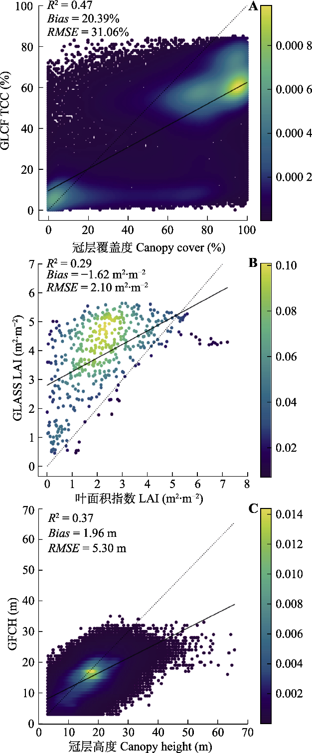
图4. 3种卫星遥感监测产品精度验证结果散点图。虚线为1:1线, 实线为拟合线; 散点图右侧的色带表示数据点的概率密度, 颜色越黄, 点密度越大。GFCH, 全球冠层高度产品; GLASS LAI, 全球叶面积指数产品; GLCF TCC, 全球冠层覆盖度产品。
Fig. 4. Accuracy of three satellite remote sensing products against unmanned aerial vehicle (UAV) LiDAR observations. The dotted line is the 1:1 line, the solid line is the fitted line, and the color bar represents the probability density of observations. GFCH, Global Forest Canopy Height; GLASS LAI, Global Land Surface Satellite Products System-Leaf Area Index; GLCF TCC, Global Land Cover Facility-Tree Canopy Cover.