
植被志书研编中图表绘制的常见问题与技术参考
收稿日期: 2024-12-23
录用日期: 2025-03-21
网络出版日期: 2025-05-07
基金资助
国家科技基础资源调查专项(2019FY202300);国家科技基础资源调查专项(2015FY210200-13)
Common issues and technical references for diagram drawing in the compilation of vegetation monographs
Received date: 2024-12-23
Accepted date: 2025-03-21
Online published: 2025-05-07
Supported by
Special Foundation for National Science and Technology Basic Resources Investigation of China(2019FY202300);Special Foundation for National Science and Technology Basic Resources Investigation of China(2015FY210200-13)
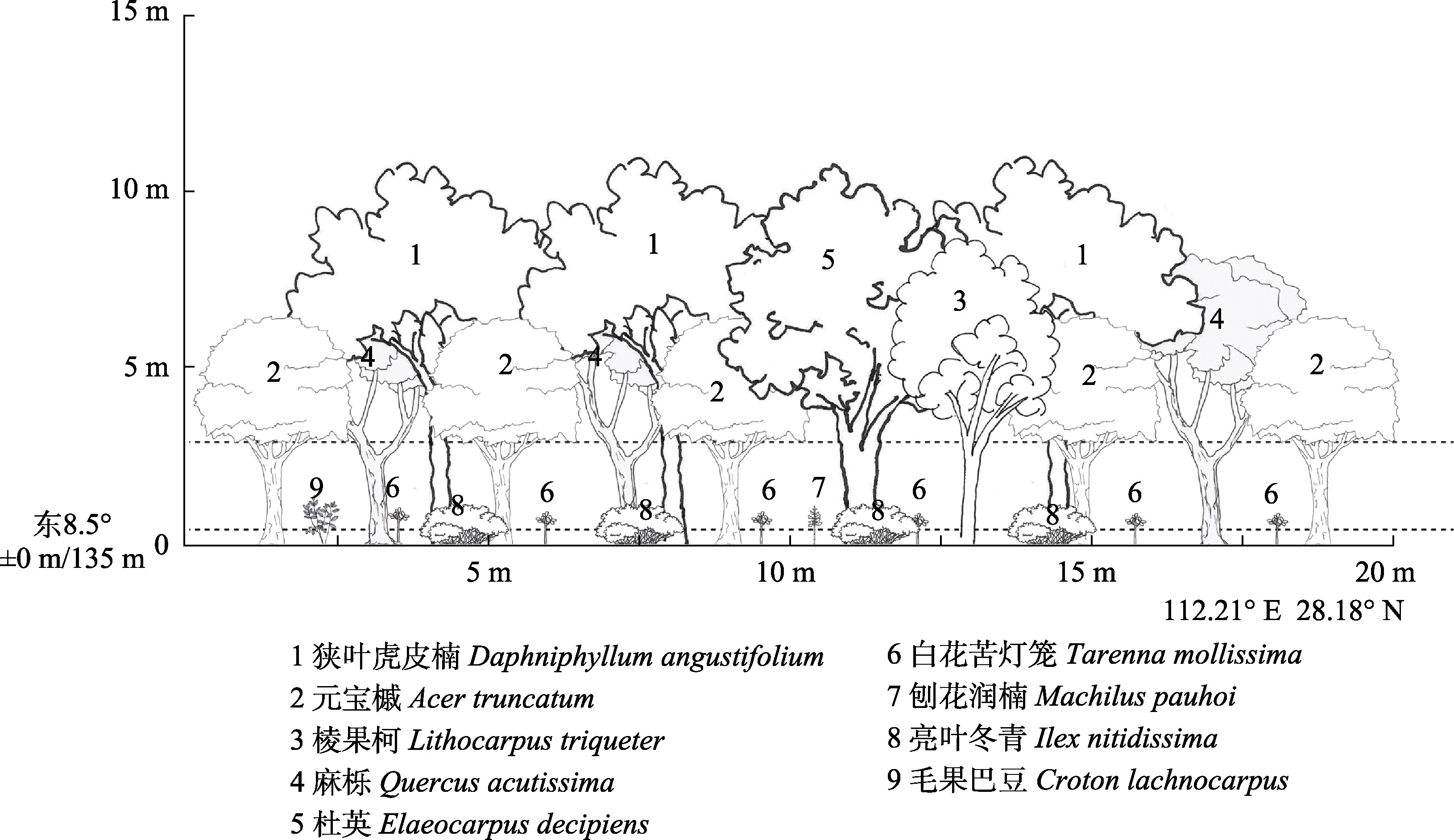
植被志书的研编是一项系统性工作, 需要在一定的规范和原则指导下进行。然而, 目前关于志书编写中图表绘制的相关规范和技术参考仍较为匮乏。该文针对植被志书研编中的群系地理分布图、群落剖面图、生态气候图、群丛分类表及其他常规图表绘制过程中存在的问题, 详细探讨了其绘制方法和技术流程。通过分析现行植被志研编框架中图表绘制的常见问题, 提出了一套科学、规范且高效的图表绘制技术方法, 包括地理分布图的底图处理与点位绘制、剖面图的调查与绘制流程、生态气候图的数据提取与可视化以及群丛分类表的数量分类方法选择等。这些方法旨在统一植被志书图表风格, 提高植被志书的整体性和科学性, 同时为后续相关志书研编及科技论文撰写中的图表绘制提供参考。
刘碧颖 , 陈子豪 , 源思浩 , 周婷 . 植被志书研编中图表绘制的常见问题与技术参考[J]. 植物生态学报, 2025 , 49(6) : 911 -921 . DOI: 10.17521/cjpe.2024.0468
The compilation of vegetation monographs is a systematic endeavor that must be conducted in accordance with established standards and guiding principles. However, there remains a notable lack of detailed guidelines and technical references regarding the construction of diagrams within these compilations. This study addresses common challenges in the preparation of diagram drawing for vegetation monographs, including geographical distribution maps of plant communities, community profile diagrams, ecological climate charts, classification tables of plant associations, and other conventional figures. It presents a comprehensive set of scientifically sound and efficient methodologies for the creation of these diagrams, such as base map processing and point plotting for distribution maps, field survey and drawing procedures for profile diagrams, data extraction and visualization techniques for ecological climate charts, and the selection of appropriate quantitative classification methods for plant associations. These proposed methods aim to standardize the visual style of diagram across vegetation monographs, enhance the overall coherence and scientific rigor of the compilations, and provide a technical reference for future monograph projects and scientific publications involving diagram drawing.
| [1] | Belbin L, McDonald C (1993). Comparing three classification strategies for use in ecology. Journal of Vegetation Science, 4, 341-348. |
| [2] | Bolliger J (2005). Simulating complex landscapes with a generic model: sensitivity to qualitative and quantitative classifications. Ecological Complexity, 2, 131-149. |
| [3] | Bruelheide H (1995). Die Gründlandgesellschaften des Harzes und ihre Standortbestimmungen. Schweizerbart Science Publishers, Stuttgart, Germany. |
| [4] | Bruelheide H (1997). Using formal logic to classify vegetation. Folia Geobotanica, 32, 41-46. |
| [5] | Bruelheide H (2000). A new measure of fidelity and its application to defining species groups. Journal of Vegetation Science, 11, 167-178. |
| [6] | Burrough PA, Wilson JP, van Gaans PFM, Hansen AJ (2001). Fuzzy k-means classification of topo-climatic data as an aid to forest mapping in the Greater Yellowstone Area, USA. Landscape Ecology, 16, 523-546. |
| [7] | Camiz S, Pillar VD (2007). Comparison of single and complete linkage clustering with the hierarchical factor classification of variables. Community Ecology, 8, 25-30. |
| [8] | Cannone N, Seppelt R (2008). A preliminary floristic classification of southern and northern Victoria Land vegetation, continental Antarctica. Antarctic Science, 20, 553-562. |
| [9] | Fang JY, Guo K, Wang GH, Tang ZY, Xie ZQ, Shen ZH, Wang RQ, Qiang S, Liang CZ, Da LJ, Yu D (2020). Vegetation classification system and classification of vegetation types used for the compilation of vegetation of China. Chinese Journal of Plant Ecology, 44, 96-110. |
| [方精云, 郭柯, 王国宏, 唐志尧, 谢宗强, 沈泽昊, 王仁卿, 强胜, 梁存柱, 达良俊, 于丹 (2020). 《中国植被志》的植被分类系统、植被类型划分及编排体系. 植物生态学报, 44, 96-110.] | |
| [10] | Fang JY, Wang GH (2020). Vegegraphy of China: surveying and describing the country’s vegetation. Chinese Journal of Plant Ecology, 44, 93-95. |
| [方精云, 王国宏 (2020). 《中国植被志》: 为中国植被登记造册. 植物生态学报, 44, 93-95.] | |
| [11] | Fick SE, Hijmans RJ (2017). WorldClim 2: new 1-km spatial resolution climate surfaces for global land areas. International Journal of Climatology, 37, 4302-4315. |
| [12] | Guijarro JA (2019). Climatol: Climate tools (series homogenization and derived products). R package version 3. [2024-03-22]. https://cran.r-project.org/package=climatol . |
| [13] | Hijmans RJ (2023). Geographic data analysis and modeling. R package raster version 3.6-20. [2025-04-17]. https://rspatial.org/raster . |
| [14] | Hill MO (1979). TWINSPAN-A FORTRAN Program for Arranging Multivariate Data in an Ordered Two-Way Table by Classification of the Individuals and Attributes. Section of Ecology and Systematics, Cornell University, Ithaca, USA. |
| [15] | Knollová I, Chytry M, Tichy L, Hájek O (2006). Local ranges of phytosociological associations: Are they reflected in numerical classification? Biologia, 61, 71-77. |
| [16] | Lai JS, Mi XC, Ren HB, Ma KP (2010). Numerical classification of associations in subtropical evergreen broad-leaved forest based on multivariate regression trees-a case study of 24 hm2 Gutianshan forest plot in China. Chinese Journal of Plant Ecology, 34, 761-769. |
| [赖江山, 米湘成, 任海保, 马克平 (2010). 基于多元回归树的常绿阔叶林群丛数量分类——以古田山24 hm2森林样地为例. 植物生态学报, 34, 761-769.] | |
| [17] | Lei SA, Walker LR (1997). Classification and ordination of coleogyne communities in southern nevada. The Great Basin Naturalist, 57, 155-162. |
| [18] | Li LL (2016). Some important problems about maps in illustrations of books and periodicals. Chuanbo yu Banquan, (9), 69-71. |
| [李兰兰 (2016). 关于书刊插图中的地图应注意的若干重大问题. 传播与版权, (9), 69-71.] | |
| [19] | Li XL, He SJ (2021). Specifications for and common problems of maps in scientific journals. Chinese Journal of Scientific and Technical Periodicals, 32, 699-718. |
| [李小玲, 何书金 (2021). 科技期刊地图插图的规范绘制和常见问题. 中国科技期刊研究, 32, 699-718.] | |
| [20] | Liu WQ (2022). Drawing Technique of Vegetatinal Scientific Illustration of Typical Forest Community in Mid-Subtropical. Master degree dissertation, Central South University of Forestry and Technology, Changsha. |
| [刘文倩 (2022). 中亚热带几种典型森林群落剖面图绘制技法. 硕士学位论文, 中南林业科技大学, 长沙.] | |
| [21] | Luo L, Song XL, Zhang SK (2015). Problems and strategies of map of China in scientific journals. Acta Editologica, 27, 437-440. |
| [罗玲, 宋晓林, 张世奎 (2015). 科技期刊中中国地图绘制的常见问题与处理对策. 编辑学报, 27, 437-440.] | |
| [22] | Sardinero S (2000). Classification and ordination of plant communities along an altitudinal gradient on the Presidential Range, New Hampshire, USA. Plant Ecology, 148, 81-103. |
| [23] | Schliep KP (2011). Phangorn: phylogenetic analysis in R. Bioinformatics, 27, 592-593. |
| [24] | Song YC (2001). Vegetation Ecology. East China Normal University Press, Shanghai. |
| [宋永昌 (2001). 植被生态学. 华东师范大学出版社, 上海.] | |
| [25] | Tichy L (2002). JUICE, software for vegetation classification. Journal of Vegetation Science, 13, 451-453. |
| [26] | Tichy L (2005). New similarity indices for the assignment of relevés to the vegetation units of an existing phytosociological classification. Plant Ecology, 179, 67-72. |
| [27] | Walter H, Lieth H (1960). World Atlas of Climate Diagrams. VEB Gustav Fischer Verlag, Jena, Germany. |
| [28] | Wang GH, Fang JY, Guo K, Xie ZQ, Tang ZY, Shen ZH, Wang RQ, Wang XP, Wang DL, Qiang S, Yu D, Peng SL, Da LJ, Liu Q, Liang CZ (2020). Contents and protocols for the classification and description of Vegetation Formations, Alliances and Associations in vegetation of China. Chinese Journal of Plant Ecology, 44, 128-178. |
| [王国宏, 方精云, 郭柯, 谢宗强, 唐志尧, 沈泽昊, 王仁卿, 王襄平, 王德利, 强胜, 于丹, 彭少麟, 达良俊, 刘庆, 梁存柱 (2020). 《中国植被志》研编内容与规范. 植物生态学报, 44, 128-178.] | |
| [29] | Xing SH, Yu MF, Yang LJ, Lin DY (2013). Discus for classification of plant association. Acta Ecologica Sinica, 33, 310-315. |
| [邢韶华, 于梦凡, 杨立娟, 林大影 (2013). 关于植物群丛划分的探讨. 生态学报, 33, 310-315.] | |
| [30] | Zeleny D (2022). TWINSPAN. R package version (development version). [2024-11-22]. https://github.com/jarioksa/twinspan . |
| [31] | Zhang HR, Tang MP (2009). Classification and succession analysis of mixed forest in Jingouling forest farm using the TWINSPAN method. Journal of Nanjing Forestry University (Natural Sciences Edition), 33(1), 37-42. |
| [张会儒, 汤孟平 (2009). 金沟岭林场混交林TWINSPAN分类及演替序列分析. 南京林业大学学报(自然科学版), 33(1), 37-42.] | |
| [32] | Zhang JT (2004). Fuzzy mathematic classification and ordination of plant communities in Pangquangou Natural Reserve. Journal of Beijing Normal University (Natural Science), 40, 249-254. |
| [张金屯 (2004). 庞泉沟自然保护区植物群落的模糊数学分类与排序. 北京师范大学学报(自然科学版), 40, 249-254.] | |
| [33] | Zhang J, Yang HX (2008). Application of self-organizing neural networks to classification of plant communities in Pangquangou Nature Reserve, North China. Frontiers of Biology in China, 3, 512-517. |
| [34] | Zomer RJ, Xu JC, Trabucco A (2022). Version 3 of the global aridity index and potential evapotranspiration database. Scientific Data, 9, 409. DOI: 10.1038/s41597-022-01493-1. |
| [35] | Zuo YJ, Shu GB, Wang CY, Peng MC, Xie YX, Zhang QY, Li FL (2021). Quantitative classification and phylogenetic structure of vegetation in valley of the middle and upper reaches of Lancang River. Chinese Journal of Ecology, 40, 2665-2677. |
| [左艳洁, 戍国标, 王崇云, 彭明春, 谢映旭, 张秋媛, 李富利 (2021). 澜沧江中上游河谷植被的群落数量分类和谱系结构. 生态学杂志, 40, 2665-2677.] |
/
| 〈 |
|
〉 |
