
植被制图色彩和符号设计原则与全国植被图图例方案
收稿日期: 2021-02-25
修回日期: 2021-04-25
网络出版日期: 2021-05-20
基金资助
第二次青藏高原综合科学考察研究(2019QZKK0301);中国科学院战略性先导科技专项(XDA19050402)
版权
Principles of color and symbol design for vegetation mapping and a scheme of national vegetation map legends
Received date: 2021-02-25
Revised date: 2021-04-25
Online published: 2021-05-20
Supported by
Second Tibetan Plateau Scientific Expedition and Research (STEP) Program(2019QZKK0301);Strategic Priority Research Program of the Chinese Academy of Sciences(XDA19050402)
Copyright
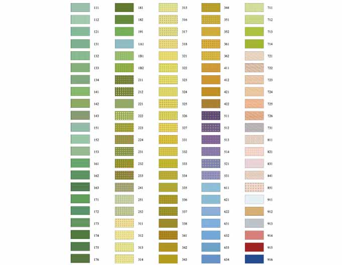
植被图通常采用不同的颜色并结合符号来区分不同的植被类型, 以期更加直观、清晰地将植被类型信息传达给读者。如何通过色彩和符号的合理搭配来区分不同的植被类型是植被制图中的关键步骤, 尤其是对于植被类型较丰富的区域, 植被图的色彩和符号设计更为复杂。植被图图例系统建立在植被分类系统之上, 近10余年来我国的植被分类系统得到了进一步的发展和完善, 因此, 非常有必要在最新的植被分类系统基础上, 提出一套植被制图色彩和符号设计方案, 用以指导当前的植被制图工作。该研究整理了地图学、植被图以及其他专题地图色彩和符号设计的要求, 提出了植被制图的色彩和符号设计原则。在最新的植被分类系统基础上, 采用颜色三属性(色调、明度、饱和度)及符号的基本视觉变量(形状、尺寸、方向、色彩、密度、亮度)的变化及其组合, 依据色彩和符号设计的系统性、科学性、象征性等原则, 对中国植被分类系统高级分类单位中的植被亚型, 进行了标准化配色和符号设计, 旨在为植被制图工作者及新一代1:50万植被图编研提供理论依据和参考, 提升植被制图的效率和质量。
贾宁霞, 郭柯, 宋创业, 刘长成 . 植被制图色彩和符号设计原则与全国植被图图例方案[J]. 植物生态学报, 2021 , 45(8) : 809 -817 . DOI: 10.17521/cjpe.2021.0065
Aims Various colors combined with symbols are usually employed to differentiate vegetation types in vegetation mapping, aiming to convey the vegetation information to readers more visually and clearly. How to differentiate vegetation types by appropriate setting of color and symbol is a key step in vegetation mapping, especially for regions with diverse vegetation types. Usually, vegetation map legends are based on the vegetation classification system. Recently, the vegetation classification system of China has been revised according to the achievements in vegetation surveys and research over the past decade. Therefore, it is necessary to put forward a new color and symbol setting scheme for vegetation mapping. Our objective is to improve the scientificity and artistry of current vegetation mapping.
Methods The principles of color and symbol setting of existing vegetation maps and other thematic maps were summarized. Based on the principles of systematicness, scientificity and symbolism, the changes and combinations of the three color attributes (hue, lightness and saturation) and the basic visual variables (shape, size, direction, color, density and brightness) of the symbols were taken in consideration for the national vegetation map legends. In the legends, Vegetation Formation Groups were differentiated by hues, and Vegetation Formations and Vegetation Subformations were represented by different lightnesses and saturations. In addition, different symbols attached to the colors were employed to distinguish vegetation types. The colors and symbols were designed to reflect the physiognomy and habitats of the vegetation types as much as possible.
Important findings The principles of color and symbol setting for vegetation mapping and a new scheme of national vegetation map legends were presented. These results would provide guideline for vegetation cartographer to set the legends of the new Chinese vegetation map (1:500 000).
Key words: color matching principle; legend design; symbol design; vegetation mapping
| [1] | Bertin J (1967). Semiologie Graphique. Mouton et Gauthier- Villars, Paris,France. |
| [2] | Cao YN, Jiang N, Wang J, Li JX (2010). The research on symbol design of electronic thematic maps based on different display styles. Hydrographic Surveying and Charting, 30(3), 73-75. |
| [ 曹亚妮, 江南, 王驹, 李嘉星 (2010). 不同显示风格的电子专题地图符号设计研究. 海洋测绘, 30(3), 73-75.] | |
| [3] | Chen LZ, Sun H, Guo K (2014). Flora and Vegetation Geography of China. Science Press, Beijing. |
| [ 陈灵芝, 孙航, 郭柯 (2014). 中国植物区系与植被地理. 科学出版社, 北京.] | |
| [4] | Chen YF (1998). Logical principles of map symbol design. Beijing Surveying and Mapping, (1), 37-39. |
| [ 陈毓芬 (1998). 地图符号设计的逻辑性原则. 北京测绘, (1), 37-39.] | |
| [5] | Cui LL, Wu MG (2017). Thematic maps gamut analysis based on kernel density estimation. Science of Surveying and Mapping, 42, 98-102. |
| [ 崔丽丽, 吴明光 (2017). 基于核密度估计方法的地图色域分析. 测绘科学, 42, 98-102.] | |
| [6] | Dai XC (2006). On the design of map symbols based on CorelDRAW9.0. Jiangxi Surveying and Mapping, (1), 44-53. |
| [ 戴新春 (2006). 浅谈基于CorelDRAW9.0的地图符号设计. 江西测绘, (1), 44-53.] | |
| [7] | Deng KW, Zeng XH (1998). Balance and coordination of colors in thematic maps. Map, (1), 37-39. |
| [ 邓康伟, 曾旭红 (1998). 专题地图配色中颜色的平衡与协调. 地图, (1), 37-39.] | |
| [8] | Gao JJ, Guan Y, Wang YL (2008). Design of basic tone of thematic map color. Geomatics and Information Science of Wuhan University, 33, 766-769. |
| [ 高建军, 关焱, 王友亮 (2008). 专题地图基调色设计研究. 武汉大学学报(信息科学版), 33, 766-769.] | |
| [9] | Guo K, Fang JY, Wang GH, Tang ZY, Xie ZQ, Shen ZH, Wang RQ, Qiang S, Liang CZ, Da LJ, Yu D (2020). A revised scheme of vegetation classification system of China. Chinese Journal of Plant Ecology, 44, 111-127. |
| [ 郭柯, 方精云, 王国宏, 唐志尧, 谢宗强, 沈泽昊, 王仁卿, 强胜, 梁存柱, 达良俊, 于丹 (2020). 中国植被分类系统修订方案. 植物生态学报, 44, 111-127.] | |
| [10] | Guo QH, Guan HC, Hu TY, Jin SC, Su YJ, Wang XJ, Wei DJ, Ma Q, Sun QH (2021). Remote sensing-based mapping method for the new generation of Vegetation Map of China (1:500 000). Scientia Sinica Vitae, 51, 229-241. |
| [ 郭庆华, 关宏灿, 胡天宇, 金时超, 苏艳军, 王雪静, 魏邓杰, 马勤, 孙千惠 (2021). 新一代1:50万中国植被图绘制方法探讨. 中国科学: 生命科学, 51, 229-241.] | |
| [11] | Han Y, Guo QS, Zhang LP, Sun Y (2007). Hybrid genetic algorithm for coloring administrative map. Geomatics and Information Science of Wuhan University, 32, 748-751. |
| [ 韩云, 郭庆胜, 章莉萍, 孙艳 (2007). 行政区划图自动着色的混合遗传算法. 武汉大学学报(信息科学版), 32, 748-751.] | |
| [12] | He MG, Wang XB (1981). On the compilation of Vegetation Map of Guangxi (1:2 500 000) with reference to its illustration. Acta Phytoecologia et Geobotanica Sinica, 5, 281-289. |
| [ 何妙光, 王献溥 (1981). 广西1:2 500 000植被图的编制及其说明. 植物生态学与地植物学丛刊, 5, 281-289.] | |
| [13] | Hou XY, Sun SZ, Zhang JW, He MG, Wang YF (1979). Vegetation Map of the People’s Republic of China (1:4 000 000). Map Publishing House, Beijing. |
| [ 侯学煜, 孙世洲, 张经炜, 何妙光, 王义风 (1979). 《中华人民共和国植被图》(1:4 000 000). 地图出版社, 北京.] | |
| [14] | Huang RT, Pang XP, Ma CY (2003). The Compilation of Thematic Maps. Wuhan University Press, Wuhan. |
| [ 黄仁涛, 庞小平, 马晨燕 (2003). 专题地图编制. 武汉大学出版社, 武汉.] | |
| [15] | Jia CQ (2003). The colour design of maps. Surveying and Mapping in Shanxi, (3), 29-30. |
| [ 贾成全 (2003). 地图的色彩设计. 三晋测绘, (3), 29-30.] | |
| [16] | Küchler AW, Zonneveld IS (1988). Vegetation Mapping. Kluwer Academic Publishers, Dordrecht, the Netherlands. |
| [17] | Li HP, Wang X, Hua LF (2015). Discussion on historical atlas symbol design method based on GIS. Geospatial Information, 13(1), 171-173. |
| [ 李海萍, 王欣, 华林甫 (2015). 基于GIS的历史地图集符号库设计方法探讨. 地理空间信息, 13(1), 171-173.] | |
| [18] | Ling SJ, Jin SS, Lu L (2004). Study on color designing of city tourist maps. Journal of Anhui Normal University (Natural Science), 27, 347-349. |
| [ 凌善金, 金世胜, 陆林 (2004). 城市旅游图色彩设计研究. 安徽师范大学学报(自然科学版), 27, 347-349.] | |
| [19] | Liu LH, Du J, Fu FE (2011). On the editing and making of thematic maps. Inner Mongolia Science Technology & Economy, (15), 104-105. |
| [ 刘利红, 杜静, 付粉娥 (2011). 浅谈专题地图的编辑与制作. 内蒙古科技与经济, (15), 104-105.] | |
| [20] | Oscar D (1905). Die Methode der Speziellen Pflanzengeographischen Kartographie. The Second International Botanical Congress, Wien, Austria. |
| [21] | Pravda J, Chen YF (1995). Map expression, map semiotics, map language. Heilongjiang Cehui, (2), 50-51. |
| [ Pravda J, 陈毓芬 (1995). 地图表示法, 地图符号学, 地图语言. 黑龙江测绘, (2), 50-51.] | |
| [22] | Qian JK, Song Y, Cheng WM (2009). Design and establishment of color system for 1:1 000 000 digital Geomorphologic Map of China. Journal of Geo-Information Science, 11, 786-794. |
| [ 钱金凯, 宋阳, 程维明 (2009). 中国1:100万地貌图色彩系统的设计与建库. 地球信息科学学报, 11, 786-794.] | |
| [23] | Song YC (2017). Vegetation Ecology. 2nd ed. Higher Education Press, Beijing. |
| [ 宋永昌 (2017). 植被生态学. 2版. 高等教育出版社, 北京.] | |
| [24] | The Editorial Committee of Vegetation Map of China, Chinese Academy of Sciences (2007a). Vegetation of China and its Geographical Pattern—Illustration of the Vegetation Map of the People’s Republic of China (1:1 000 000). Geological Publishing House, Beijing. |
| [中国科学院中国植被图编辑委员会 (2007a). 中国植被及其地理格局——中华人民共和国植被图(1:1 000 000)说明书. 地质出版社, 北京.] | |
| [25] | The Editorial Committee of Vegetation Map of China, Chinese Academy of Sciences (2007b). Vegetation Map of the People’s Republic of China (1:1 000 000). Geological Publishing House, Beijing. |
| [中国科学院中国植被图编辑委员会 (2007b). 中华人民共和国植被图(1:1 000 000). 地质出版社, 北京.] | |
| [26] | Tian LS (1993). Vegetation Mapping. Xi’an Map Press, Xi’an. |
| [ 田连恕 (1993). 植被制图. 西安地图出版社, 西安.] | |
| [27] | Tyner JA (2010). Principles of Map Design. The Guilford Press, New York. |
| [28] | UNESCO (United Nations Educational Scientific and Cultural Organization) (1973). International Classification and Mapping of Vegetation. UNESCO, Paris. |
| [29] | Wang L, Dong L, Hu TY, Guo K (2021). History and prospect of vegetation map compilation in China. Scientia Sinica Vitae, 51, 219-228. |
| [ 王乐, 董雷, 胡天宇, 郭柯 (2021). 中国植被图编研历史与展望. 中国科学: 生命科学, 51, 219-228.] | |
| [30] | Wen CJ, Cui GS, Wang M (2010). Restrictive factors and principles of seabed sediment elements symbols design. Science of Surveying and Mapping, 35(suppl.), 66-68. |
| [ 温朝江, 崔高嵩, 王沫 (2010). 海洋底质要素符号设计的制约因素和原则. 测绘科学, 35(增), 66-68.] | |
| [31] | Wu XL (2014). A New Color Scheme System for Foreground & Background Symbols in Thematic Maps: Design and Evaluation. Master degree dissertation, East China Normal University, Shanghai. |
| [ 吴笑乐 (2014). 专题地图符号前-背景配色方案助选系统设计与评测. 硕士学位论文, 华东师范大学, 上海.] | |
| [32] | Wu ZH (2007). Research on the Design of Tourist Web Map. Master degree dissertation, PLA Information Engineering University, Zhengzhou. |
| [ 吴增红 (2007). 旅游网络地图设计研究. 硕士学位论文, 解放军信息工程大学, 郑州.] | |
| [33] | Wu ZY (1980). Vegetation of China. Science Press, Beijing. |
| [ 吴征镒 (1980). 中国植被. 科学出版社, 北京.] | |
| [34] | Yuan YX, Liu XJ, Yuan XY (2020). Discuss the design of symbol system for thematic map. Geomatics & Spatial Information Technology, 43(2), 200-203. |
| [ 袁月欣, 刘秀军, 袁晓妍 (2020). 浅谈专题地图符号系统的设计. 测绘与空间地理信息, 43(2), 200-203.] | |
| [35] | Zhang JJ (2016). Symbol design method for emergency thematic map icon standardization: a case study of Fuzhou City. Geomatics & Spatial Information Technology, 39(10), 49-51. |
| [ 张佳佳 (2016). 面向应急专题地图图标标准化的符号设计方法——以福建省为例. 测绘与空间地理信息, 39(10), 49-51.] | |
| [36] | Zhang YL (2004). The Design and Implementation of A Mapobject Based Special Subject Map Symbol Base. Master degree dissertation, Wuhan University, Wuhan. |
| [ 张永利 (2004). 基于MapObject的专题地图符号库的设计与实现. 硕士学位论文, 武汉大学, 武汉.] | |
| [37] | Zheng SL, Yang CL, Wang CS, Liu XH (2015). Area symbol color fidelity cognition and gender differences. Hydrographic Surveying and Charting, 35(5), 24-27. |
| [ 郑束蕾, 杨春雷, 王成舜, 刘晓寒 (2015). 地图面状符号色彩真实度认知及性别差异分析. 海洋测绘, 35(5), 24-27.] | |
| [38] | Zhong X, Li L, Zhu HH (2012). Research on the map design aiming at color vision impaired. Science of Surveying and Mapping, 37(4), 90-92. |
| [ 钟璇, 李霖, 朱海红 (2012). 针对色觉异常人群的地图设计研究. 测绘科学, 37(4), 90-92.] | |
| [39] | Zhou LH, Sun SZ (1990). Vegetation Map of Qinghai Province (1:1 000 000). China Science and Technology Press, Beijing. |
| [ 周立华, 孙世洲 (1990). 青海省植被图(1:1 000 000). 中国科学技术出版社, 北京.] | |
| [40] | Zhu GR, Guo LZ, Yin GB, Xu YL (2010). Map Design and Compilation. 2nd ed. Wuhan University Press, Wuhan. |
| [ 祝国瑞, 郭礼珍, 尹贡白, 徐永利 (2010). 地图设计与编绘. 2版. 武汉大学出版社, 武汉.] | |
| [41] | Zhu YT, Chen YL, Chai CQ, Hu YP (2018). Map design of Gannan food culture based on ArcGIS. Journal of Gannan Normal University, 39(6), 103-107. |
| [ 朱玉婷, 陈永林, 柴超前, 胡月萍 (2018). 基于ArcGIS的赣南饮食民俗地图设计. 赣南师范大学学报, 39(6), 103-107.] |
/
| 〈 |
|
〉 |
Copyright © 2026 版权所有 《植物生态学报》编辑部
地址: 北京香山南辛村20号, 邮编: 100093
Tel.: 010-62836134, 62836138; Fax: 010-82599431; E-mail: apes@ibcas.ac.cn, cjpe@ibcas.ac.cn
备案号: 京ICP备16067583号-19
![]()
