
Chin J Plant Ecol ›› 2005, Vol. 29 ›› Issue (2): 208-217.DOI: 10.17521/cjpe.2005.0027
Previous Articles Next Articles
ZHOU Chuan-Yan1,2, ZHOU Guo-Yi1,*( ), YAN Jun-Hua1, WANG Xu1
Received:2004-02-18
Accepted:2004-12-02
Online:2005-02-18
Published:2005-03-10
Contact:
ZHOU Guo-Yi
ZHOU Chuan-Yan, ZHOU Guo-Yi, YAN Jun-Hua, WANG Xu. LONG-TERM COMPARATIVE STUDY OF THE HYDROLOGICAL CHARACTERISTICS OF FORESTS IN DIFFERENT SUCCESSIONAL STAGES IN THE DINGHUSHAN BIOSPHERE RESERVE, GUANGDONG PROVINCE, CHINA[J]. Chin J Plant Ecol, 2005, 29(2): 208-217.
Add to citation manager EndNote|Ris|BibTeX
URL: https://www.plant-ecology.com/EN/10.17521/cjpe.2005.0027
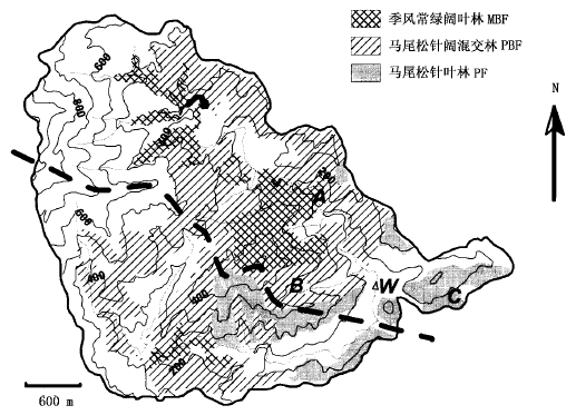
Fig.1 Forest distribution in Dinghushan biosphere reserve
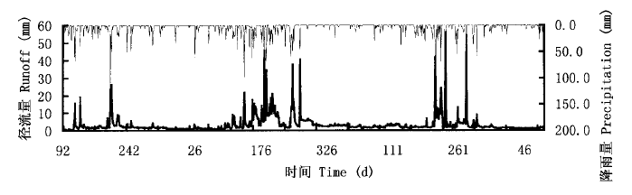
Fig.2 Daily runoff and precipitation in eastern watershed of Dinghushan biosphere reserve during Apr. 2000-Mar. 2003
| 年份 Year | 干湿季 Season | n1 | n2 | Rss (mm) | Rsf (mm) | Rss+Rsf (mm) | P (mm) | RssRss+RsfRssRss+Rsf | RssPRssΡ | RsfPRsfΡ | Rss+RsfPRss+RsfΡ |
|---|---|---|---|---|---|---|---|---|---|---|---|
| 2000年4月~2001年3月 Apr.2000-Mar.2001 | 湿季 Wet season | 94 | 89 | 358.8 | 150.2 | 509.0 | 1 178.9 | 0.705 | 0.304 | 0.127 | 0.432 |
| 干季 Dry season | 129 | 53 | 197.5 | 32.7 | 230.2 | 512.1 | 0.858 | 0.386 | 0.064 | 0.450 | |
| 2001年4月~2002年3月 Apr.2001-Mar.2002 | 湿季 Wet season | 81 | 102 | 845.6 | 408.4 | 1 254.0 | 1 737.2 | 0.674 | 0.487 | 0.235 | 0.722 |
| 干季 Dry season | 141 | 41 | 481.3 | 15.1 | 496.4 | 206.3 | 0.970 | 2.333 | 0.073 | 2.406 | |
| 2002年4月~2003年3月 Apr.2002-Mar.2003 | 湿季 Wet season | 102 | 81 | 515.5 | 232.9 | 748.4 | 1 271.8 | 0.689 | 0.405 | 0.183 | 0.588 |
| 干季 Dry season | 122 | 60 | 364.7 | 25.6 | 390.3 | 548.1 | 0.934 | 0.665 | 0.047 | 0.712 | |
| 总和 Total | 669 | 426 | 2 894.2 | 734.1 | 3 628.3 | 5 454.4 | / | / | / | / |
Table 1 Parameters in Eq (1) for the eastern watershed
| 年份 Year | 干湿季 Season | n1 | n2 | Rss (mm) | Rsf (mm) | Rss+Rsf (mm) | P (mm) | RssRss+RsfRssRss+Rsf | RssPRssΡ | RsfPRsfΡ | Rss+RsfPRss+RsfΡ |
|---|---|---|---|---|---|---|---|---|---|---|---|
| 2000年4月~2001年3月 Apr.2000-Mar.2001 | 湿季 Wet season | 94 | 89 | 358.8 | 150.2 | 509.0 | 1 178.9 | 0.705 | 0.304 | 0.127 | 0.432 |
| 干季 Dry season | 129 | 53 | 197.5 | 32.7 | 230.2 | 512.1 | 0.858 | 0.386 | 0.064 | 0.450 | |
| 2001年4月~2002年3月 Apr.2001-Mar.2002 | 湿季 Wet season | 81 | 102 | 845.6 | 408.4 | 1 254.0 | 1 737.2 | 0.674 | 0.487 | 0.235 | 0.722 |
| 干季 Dry season | 141 | 41 | 481.3 | 15.1 | 496.4 | 206.3 | 0.970 | 2.333 | 0.073 | 2.406 | |
| 2002年4月~2003年3月 Apr.2002-Mar.2003 | 湿季 Wet season | 102 | 81 | 515.5 | 232.9 | 748.4 | 1 271.8 | 0.689 | 0.405 | 0.183 | 0.588 |
| 干季 Dry season | 122 | 60 | 364.7 | 25.6 | 390.3 | 548.1 | 0.934 | 0.665 | 0.047 | 0.712 | |
| 总和 Total | 669 | 426 | 2 894.2 | 734.1 | 3 628.3 | 5 454.4 | / | / | / | / |
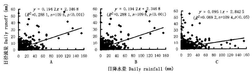
Fig.3 The correlation of daily rainfall and runoff for the eastern watershed
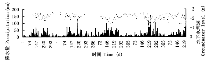
Fig.4 Comparison of groundwater level and daily precipitation in Dinghushan biosphere reserve
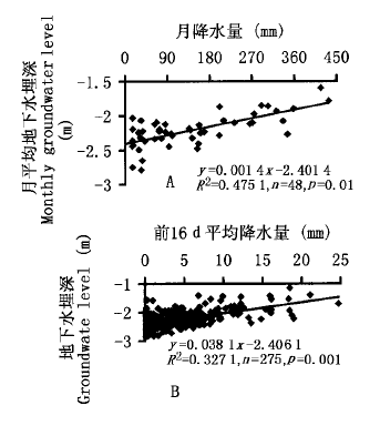
Fig.5 The correlation of groundwater level with the average rainfall of different periods
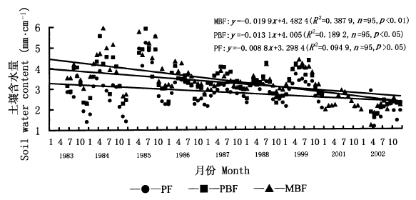
Fig.6 Monthly soil water content in the three forest types during 1983-2002 PF、 See Fig.1
| 时段 Periods | 1983~1985 | 1986~1999 | 2001~2002 | |||||
|---|---|---|---|---|---|---|---|---|
| 平均值Mean (mm·cm-1) | 标准差δ | 平均值Mean (mm·cm-1) | 标准差δ | 平均值Mean (mm·cm-1) | 标准差δ | |||
| 马尾松针叶林PF | 3.11 | 1.11 | 2.87 | 0.44 | 1.89 | 0.45 | ||
| 马尾松针阔混交林PBF | 3.73 | 1.02 | 3.33 | 0.53 | 2.09 | 0.27 | ||
| 季风常绿阔叶林MBF | 4.12 | 1.01 | 3.42 | 0.44 | 2.20 | 0.35 | ||
Table 2 Average and standard deviation (δ) of soil water content for the three forests types in different periods
| 时段 Periods | 1983~1985 | 1986~1999 | 2001~2002 | |||||
|---|---|---|---|---|---|---|---|---|
| 平均值Mean (mm·cm-1) | 标准差δ | 平均值Mean (mm·cm-1) | 标准差δ | 平均值Mean (mm·cm-1) | 标准差δ | |||
| 马尾松针叶林PF | 3.11 | 1.11 | 2.87 | 0.44 | 1.89 | 0.45 | ||
| 马尾松针阔混交林PBF | 3.73 | 1.02 | 3.33 | 0.53 | 2.09 | 0.27 | ||
| 季风常绿阔叶林MBF | 4.12 | 1.01 | 3.42 | 0.44 | 2.20 | 0.35 | ||
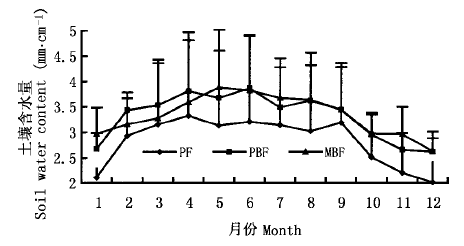
Fig.7 Annual change of soil water content for the three forest types See Fig.1
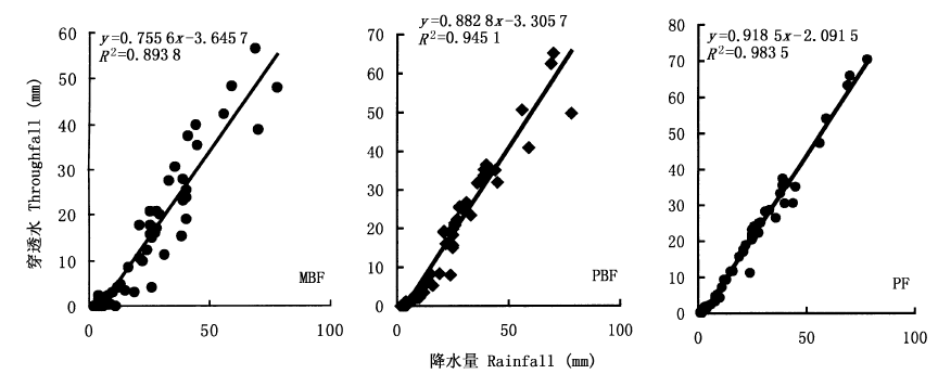
Fig.8 The relationship between throughfall and rainfall for the three forest types See Fig.1
| 林型 Forest types | 季风常绿阔叶林MBF | 马尾松针阔混交林PBF | 马尾松针叶林PF |
|---|---|---|---|
| 叶面积指数Leaf area index | 17.76±1.2 | 11.28±1.6 | 6.61±2.1 |
| 郁闭度Canopy cover | 93% | 86% | 58% |
Table 3 Leaf area index and canopy cover of three forest types
| 林型 Forest types | 季风常绿阔叶林MBF | 马尾松针阔混交林PBF | 马尾松针叶林PF |
|---|---|---|---|
| 叶面积指数Leaf area index | 17.76±1.2 | 11.28±1.6 | 6.61±2.1 |
| 郁闭度Canopy cover | 93% | 86% | 58% |

Fig.9 The relationship between annual stem flow and diameter at breast height (DBH) for masson pines (Pinus massoniana) growing in PF and PBF See Fig.1
| 林型 Forest types | 马尾松针叶林PF | 马尾松针阔混交林PBF | 季风常绿阔叶林MBF |
|---|---|---|---|
| 降雨量 Rainfall (%) | 100.0 | 100.0 | 100.0 |
| 穿透水 Throughfall (%) | 83.4±9.2 | 68.3±8.6 | 59.9±3.5 |
| 树干茎流 Stemflow (%) | 1.9±1.1 | 6.5±1.6 | 8.3±1.1 |
| 林冠截留 Interception (%) | 14.7±9.3 | 25.2±8.7 | 31.8±3.7 |
Table 4 Distribution pattern of rainfall by the canopy for three forest types in Dinghushan from 1998-2003
| 林型 Forest types | 马尾松针叶林PF | 马尾松针阔混交林PBF | 季风常绿阔叶林MBF |
|---|---|---|---|
| 降雨量 Rainfall (%) | 100.0 | 100.0 | 100.0 |
| 穿透水 Throughfall (%) | 83.4±9.2 | 68.3±8.6 | 59.9±3.5 |
| 树干茎流 Stemflow (%) | 1.9±1.1 | 6.5±1.6 | 8.3±1.1 |
| 林冠截留 Interception (%) | 14.7±9.3 | 25.2±8.7 | 31.8±3.7 |
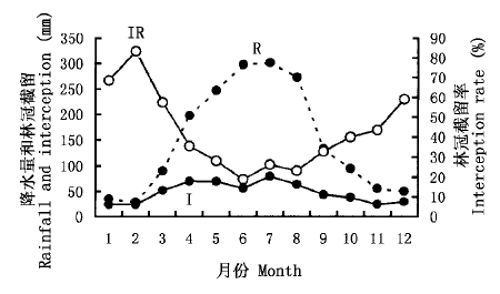
Fig.10 Monthly changes of rainfall (R), interception (I) and interception rate (IR) in MBF
| [1] | Aboal JR, Morales D, Hernandez M, Jimenez MS (1999). ThemeasurementandmodelingofthevariationofstemflowinalaurelforestinTenerife, CanaryIslands. JournalofHy drology, 221,161-175. |
| [2] | Bosch JM, Hewlett JD (1982). Areviewofcatchmentexperi mentstodeterminetheeffectofvegetationchangesonwateryieldandevapotranspiration. JournalofHydrology, 55,3-23. |
| [3] | Carlyle-Moses DE, Price AG (1999). AnevaluationoftheGashinterceptionmodelinanorthernhardwoodstand. JournalofHydrology, 214,103-110. |
| [4] | Fang YT (方运霆), Mo JM (莫江明), Zhang QM (张倩媚), Zhang YC (张佑昌), Xu GL (徐国良) (2002). SoilcarbonstorageanddistributionforthreetypesofForestsinDinghushan. TropicalandSubtropicalForestEcosystem (热带亚热带森林生态系统研究), 9,115-124. (inChinesewithEnglishabstract). |
| [5] | Gash JHC, Morton AJ (1978). AnapplicationoftheRuttermodeltotheestimationoftheinterceptionlossfromThetfordforest. JournalofHydrology, 38,49-58. |
| [6] | Haworth K, McPherson GR (1995). EffectsofQuercuse moryitreesonprecipitationdistributionandmicroclimateinasemi_aridsavanna. JournalofAridEnvironment, 31,153-170. |
| [7] | Helvey JD (1967). Interceptionbyeasternwhitepine. WaterResourcesResearch, 3,723-729. |
| [8] | Helvey JD, Patric JH (1965). CanopyandlitterinterceptionofrainfallbyhardwoodsofeasternUnitedStates. WaterRe sourcesResearch, 1,193-206. |
| [9] | Levia DF, Frost E (2003). Areviewandevaluationofstem flowliteratureinthehydrologicandbiogeochemicalcyclesofforestedandagriculturalecosystems. JournalofHydrology, 274,1-29. |
| [10] | Mo JM (莫江明), Brown S, Kong GH (孔国辉), Lenart M, Zhang YC (张佑昌) (1997). LitterdecompositionanditsnutrientdynamicsofapineforestinDinghushanBiosphereReserve. ActaPhytoecologicaSinica (植物生态学报), 20,534-542. (inChinesewithEnglishabstract). |
| [11] | Nyholm T, Rasmussen KR, Christensen S (2003). Estimationofstreamflowdepletionanduncertaintyfromdischargemea surementsinasmallalluvialstream. JournalofHydrology, 274,129-144. |
| [12] | Peng SL (彭少麟), Fang W (方炜) (1995). Studiesondy namicsofCastanopsischinensisandSchimasuperbapopula tioninforestsuccessionofDinghushanMountain. ActaPhy toecologicaSinica (植物生态学报), 19,311-318. (inChi nesewithEnglishabstract). |
| [13] | Sarmiento JL, Gruber N (2002). Sinksforanthropogeniccar bon. PhysicsToday, 8,30-36. |
| [14] |
Schimel DS, Ciasis P, Peylin P (2001). Recentpatternsandmechanismsofcarbonexchangebyterrestrialecosystems. Nature, 414,169-172.
PMID |
| [15] |
Swank WT, Douglass JE (1974). Streamflow greatlyreducedbyconvertingdeciduoushardwoodstandstopine. Science, 185,857-859.
DOI URL |
| [16] | Tallaksen LM (1995). Areviewofbaseflowrecessionanalysis. JournalofHydrology, 165,349-370. |
| [17] | Wen DZ (温达志), Wei P (魏平), Zhang QM (张倩媚), Kong GH (孔国辉) (1999). Studiesonbiomassofthreelowersubtropicalev ergreenbroad-leavedforestsinaMabReserveofSouthChina. ActaPhytoecologicaSinica (植物生态学报), 23 (Suppl.),11-21. (inChinesewithEnglishabstract). |
| [18] | Wu HS (吴厚水), Liu HP (刘慧屏), Huang DJ (黄大基) (1998). Theinterceptioneffectofthemonsoonevergreenbroad-leavedforestonprecipitationinDinghushanBiosphereReserve. TropicalandSubtropicalForestEcosystem (热带亚热带森林生态系统研究), 8,146-149. (inChinesewithEnglishabstract). |
| [19] | Zhou GY, Morris JD, Yan JH, Yu ZY, Peng SL (2002a). Hydrologicalimpactsofreafforestationwitheucalyptusandindigenousspecies:acasestudyinsouthernChina. ForestE cologyandManagement, 167,209-222. |
| [20] |
Zhou GY, Wei XH, Yan JH (2002b). Impactsofeucalyptus (Eucalyptusexserta) plantationonsedimentyieldinGuang dongprovince, SouthernChina———akineticenergyap proach. CATENA, 49,231-251.
DOI URL |
| [21] | Zhou GY (周国逸) (1997). PrinciplesandApplicationsofWaterandHeatinEcosystem (生态系统水热原理及其应用). ChinaMeteorologicalPress, Beijing. (inChinese). |
| Viewed | ||||||
|
Full text |
|
|||||
|
Abstract |
|
|||||
Copyright © 2026 Chinese Journal of Plant Ecology
Tel: 010-62836134, 62836138, E-mail: apes@ibcas.ac.cn, cjpe@ibcas.ac.cn
![]()