
植物生态学报 ›› 2005, Vol. 29 ›› Issue (2): 175-184.DOI: 10.17521/cjpe.2005.0023
• 论文 • 下一篇
倪健, 郭柯, 刘海江, 张新时*( )
)
收稿日期:2003-12-31
接受日期:2004-10-19
出版日期:2005-12-31
发布日期:2005-03-10
通讯作者:
张新时
作者简介:*E-mail:xinshiz@yahoo.com基金资助:
NI Jian, GUO Ke, LIU Hai-Jiang, ZHANG Xin-Shi*()
Received:2003-12-31
Accepted:2004-10-19
Online:2005-12-31
Published:2005-03-10
Contact:
ZHANG Xin-Shi
摘要:
从国内外生态区划、生态土地分类和生态 生产范式的研究和发展入手, 从生态利用的角度出发, 在西北干旱区生态区域分异规律的基础上, 结合当地的社会经济发展特点, 全面完成了西北干旱区的生态区划方案。本着既尊重自然规律又符合可持续发展的生态 生产范式的原则, 在西北干旱区的生态区划过程中, 主要考虑以下几个方面:气候与巨地形系统、地貌与基质、植被与土壤以及土地利用与产业发展方向;区划方法是以经验判别和地理信息系统 (GIS) 相结合进行的, 过去发表的多种尺度的图件和区划方案均作为分区过程的辅助材料和新区划方案的校正材料;根据气候、巨地形系统、地貌、基质、植被、土壤以及土地利用和产业 发展方向等特征, 该生态区划的 3级分区指标如下:一级分区, 主要依据气候和巨地形系统, 并充分考虑该高级分区在生态环境建设和产业结构调整中的作用;二级分区, 主要根据次级地形和地貌系统以及大尺度植被类型;三级分区, 主要依据基质和土壤的差异所造成的局域植被类型的差异, 以及其生态 生产范式和将来的发展方向。根据以上区划的原则和指标体系, 西北干旱区的生态区划采用 3级区划制:生态域 (Ecodomain) 、生态区 (Ecoregion) 、生态小区 (Ecodistrict), 最后将西北干旱区划分为 3个生态域、2 3个生态区和 80个生态小区, 并利用GIS绘制了 1∶10 0万比例尺的西北干旱区生态区划图。西北干旱区生态区划的目的不仅在于发展独特的干旱区生态区划/生态分类的方法和理论体系, 建立生态区划的方案和生态 生产范式, 更重要的是要运用这些方法、规律和范式来指导当地的生态环境建设和产业结构调整, 促进当地的土地资源合理配置, 实现西北干旱区的可持续发展。
倪健, 郭柯, 刘海江, 张新时. 中国西北干旱区生态区划. 植物生态学报, 2005, 29(2): 175-184. DOI: 10.17521/cjpe.2005.0023
NI Jian, GUO Ke, LIU Hai-Jiang, ZHANG Xin-Shi. ECOLOGICAL REGIONALIZATION OF ARID LANDS IN NORTHWESTERN CHINA. Chinese Journal of Plant Ecology, 2005, 29(2): 175-184. DOI: 10.17521/cjpe.2005.0023
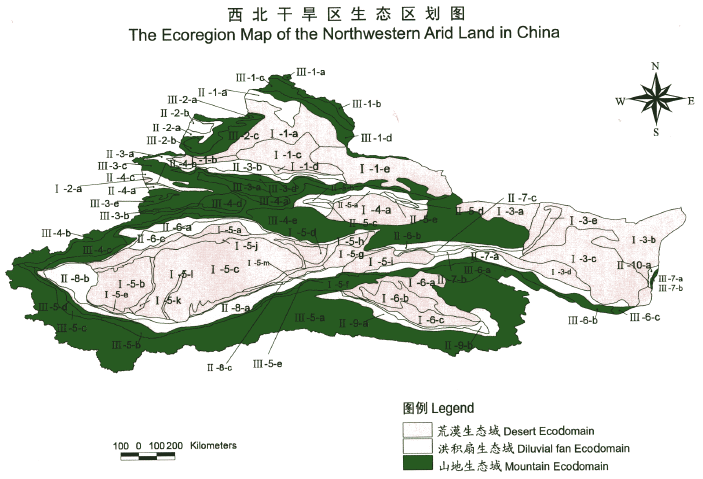
图1 中国西北干旱区生态区划概图 下载原图 I 温带荒漠盆地自然保育生态域I-1 准噶尔盆地温带荒漠生态区I-1-a 准噶尔北部砾质荒漠生态小区I-1-b 艾比湖盐沼和壤质荒漠生态小区I-1-c古尔班通古特沙漠生态小区I-1-d 准噶尔南缘壤质荒漠生态小区I-1-e 准噶尔东部砾质荒漠生态小区I-2伊犁谷地温带沙漠生态区I-2-a 伊犁谷地沙漠生态小区I-3河西走廊/阿拉善高原温带荒漠生态区I-3-a阿拉善西部戈壁荒漠生态小区I-3-b阿拉善北部砾质荒漠生态小区I-3-c 阿拉善沙漠生态小区I-3-d 河西壤质荒漠生态小区I-3-e 黑河下游荒漠河岸林生态小区I-4 吐哈盆地暖温带荒漠生态区I-4-a 吐哈盆地砾质荒漠生态小区I-5 塔里木盆地暖温带荒漠生态区I-5-a塔里木北部壤质荒漠生态小区I-5-b塔克拉玛干沙漠和田河西部生态小区I-5-c塔克拉玛干沙漠中部生态小区 I-5-d塔克拉玛干沙漠塔里木河东部生态小区I-5-e塔里木西南部壤质荒漠生态小区I-5-f 塔里木东南部壤质荒漠生态小区I-5-g 塔里木东部壤质荒漠生态小区I-5-h罗布戈壁雅丹与盐漠生态小区I-5-i库木塔格沙漠生态小区I-5-j塔里木河河岸林生态小区I-5-k 塔里木盆地和田河河岸林生态小区I-5-l 塔里木盆地克里雅河河岸林生态小区I-5-m塔里木盆地车尔臣河河岸林生态小区I-6 柴达木盆地冷温带荒漠生态区I-6-a 柴达木北部砾质荒漠生态小区I-6-b 柴达木雅丹与沙漠生态小区I-6-c 柴达木南缘盐沼生态小区II 温带洪积扇缘农林畜牧绿洲生态域II-1 阿尔泰山南麓山前洪积扇生态区II-1-a 阿尔泰山南麓河谷与绿洲复合生态小区II-2 塔城盆地洪积扇生态区II-2-a 塔城盆地边缘潜水涵养生态小区II-2-b 塔城盆地荒漠与绿洲复合生态小区II-3 天山北麓山前洪积扇生态区II-3-a 天山北麓砾石戈壁潜水涵养生态小区II-3-b 天山北麓山前绿洲与扇缘潜水溢出带复合生态小区II-4 伊犁谷地洪积扇生态区II-4-a 伊犁谷地砾石戈壁潜水涵养生态小区II-4-b 伊犁谷地绿洲与扇缘潜水溢出带复合生态小区II-4-c 伊犁谷地河谷绿洲生态小区II-5 吐哈 (东疆) 山前洪积扇生态区II-5-a 吐哈砾石戈壁潜水涵养生态小区II-5-b 吐鲁番山前绿洲生态小区II-5-c 吐鲁番扇缘潜水溢出带生态小区II-5-d 哈密山前绿洲生态小区II-5-e 哈密扇缘潜水溢出带生态小区II-6 天山南麓山前洪积扇生态区II-6-a 天山南麓砾石戈壁潜水涵养生态小区II-6-b 北山南麓山前砾石戈壁潜水涵养生态小区II-6-c 天山南麓山前绿洲与扇缘潜水溢出带复合生态小区II-7 河西 (祁连山北麓) 山前洪积扇生态区II-7-a 河西山前砾石戈壁潜水涵养与绿洲复合生态小区II-7-b 河西山前绿洲与扇缘潜水溢出带复合生态小区II-7-c 疏勒河河谷盐沼荒漠生态小区II-8 昆仑山前洪积扇生态区II-8-a 昆仑山北麓砾石戈壁潜水涵养生态小区II-8-b 昆仑山北麓山前绿洲生态小区II-8-c 昆仑山北麓扇缘潜水溢出带生态小区II-9 柴达木 (东昆仑山北麓) 山前洪积扇生态区II-9-a 柴达木砾石戈壁潜水涵养生态小区II-9-b 柴达木山前绿洲与扇缘潜水溢出带复合生态小区II-10 贺兰山西麓水源涵养生态区II-10-a 贺兰山西麓水源涵养生态小区III 温带山地森林-草原/荒漠休养恢复生态域III-1 阿尔泰山地森林-草原生态区III-1-a 阿尔泰高山冻原生态小区III-1-b 阿尔泰高山草甸-草原生态小区III-1-c 阿尔泰中山森林-草原生态小区III-1-d 阿尔泰低山荒漠草原生态小区III-2 准噶尔西部山地森林-草原生态区III-2-a 准噶尔西部高山草甸生态小区III-2-b 准噶尔西部中山森林-草原生态小区III-2-c 准噶尔西部低山荒漠草原生态小区III-3 天山北坡山地森林-草原生态区III-3-a 北天山北坡高山草甸生态小区III-3-b 南天山北坡高山草甸生态小区III-3-c 天山北坡中山森林-草原生态小区III-3-d 天山北坡低山荒漠生态小区III-3-e 特克斯河谷草原生态小区III-4 天山南坡山地草原生态区III-4-a 北天山南坡高山草甸生态小区III-4-b 南天山南坡高山草甸生态小区III-4-c 天山南坡中山灌丛-草原复合生态小区III-4-d 尤尔都斯盆地草原生态小区III-4-e 天山南坡低山荒漠生态小区III-5 昆仑山山地荒漠生态区III-5-a 昆仑山高山湖盆高寒荒漠、草原与草甸生态小区III-5-b 昆仑山北坡中山草原生态小区III-5-c 昆仑山北坡中山森林-草原生态小区III-5-d 昆仑山北坡低山荒漠生态小区III-5-e 阿尔金山北坡低山荒漠生态小区III-6 祁连山北坡山地森林-草原生态区III-6-a 祁连山北坡高山草甸-草原生态小区III-6-b 祁连山北坡中山森林-草原生态小区III-6-c 祁连山北坡低山荒漠生态小区III-7 贺兰山西坡山地森林-草原生态区III-7-a 贺兰山西坡中山森林-草原生态小区
Fig.1 Sketch map of the ecological regionalization of northwestern arid land in China
| [1] | Bailey RG (1980). Description of the Ecoregions of the United States. United States Department of Agriculture, Washington, DC, 77. |
| [2] |
Bailey RG (1983). Delineation of ecosystem regions. Environmental Management, 7,365-373.
DOI URL |
| [3] | Bailey RG (1984). Testing an ecosystem regionalization. Journal of Environmental Management, 19,239-248. |
| [4] |
Bailey RG (1985). The factor of scale in ecosystem mapping. Environmental Management, 9,271-276.
DOI URL |
| [5] |
Bailey RG (1987). Suggested hierarchy of criteria for multi-scale ecosystem mapping. Landscape and Urban Planning, 14,313-319.
DOI URL |
| [6] |
Bailey RG (1989). Explanatory supplement to ecoregions map of the continents. Environmental Conservation, 16,307-309.
DOI URL |
| [7] |
Bailey RG (1991). Design of ecological networks for monitoring global change. Environmental Conservation, 18,173-175.
DOI URL |
| [8] | Bailey RG (1996a). Ecosystem Geography. Springer-Verlag, New York, 216. |
| [9] |
Bailey RG (1996b). Multi-scale ecosystem analysis. Environmental Monitoring and Assessment, 39,21-24.
DOI URL |
| [10] | Bailey RG (1998a). Ecoregions Map of North America: Explanatory Note. United States Department of Agriculture, Washington, DC, 10. |
| [11] | Bailey RG (1998b). Ecoregions:the Ecosystem Geography of the Ocean and Continents. Springer-Verlag, New York, 192. |
| [12] |
Bailey RG, Hogg HC (1986). A world ecoregions map for resource reporting. Environmental Conservation, 13,195-202.
DOI URL |
| [13] | Bailey RG, Zoltai SC, Wiken EB (1985). Ecological regionalization in Canada and the United States. Geoforum, 116,265-275. |
| [14] |
Banner A, Meidinger DV, Lea EC, Maxwell RE, von Sacken BC (1996). Ecosystem mapping methods for British Columbia. Environmental Monitoring and Assessment, 39,97-117.
DOI PMID |
| [15] |
Bashkin VN, Bailey RG (1993). Revision of map of ecoregions of the world(1992-95). Environmental Conservation, 20,75-76.
DOI URL |
| [16] | Committee of National Agricultural Resource Survey and Agricultural Regionalization (全国农业自然资源调查和农业区划委员会) (1980). Outline of Comprehensive Physical Regionalization in China (中国综合自然区划纲要). Science Press, Beijing. (in Chinese) |
| [17] | ECOMAP (1993). National Hierarchical Framework of Ecological Units. United States Department of Agriculture, Forest Service, Washington, DC, 20. |
| [18] | Editorial Committee for Vegetation of China (中国植被编辑委员会) (1980). Vegetation of China (中国植被). Science Press, Beijing. (in Chinese) |
| [19] | Fu BJ (傅伯杰), Liu GH (刘国华), Chen LD (陈利顶), Ma KM (马克明), Li JR (李俊然) (2001). Scheme of ecological regionalization in China. Acta Ecologica Sinica (生态学报), 21,1-6. (in Chinese with English abstract) |
| [20] |
Hanson DS, Hargrave B (1996). Development of a multilevel ecological classification system for the State of Minnesota. Environmental Monitoring and Assessment, 39,75-84.
DOI PMID |
| [21] | Holdridge LR (1967). Life Zone Ecology. Tropical Science Center, San Jose, 206. |
| [22] | Hou XY (侯学煜) (1988a). Physical ecoregion of China and mega-agricultural development (I). Bulletin of Chinese Academy of Sciences (中国科学院院刊), (1),28-37. (in Chinese) |
| [23] | Hou XY (侯学煜) (1988b). Physical ecoregion of China and mega-agricultural development (II). Bulletin of Chinese Academy of Sciences (中国科学院院刊), (2),137-152. (in Chinese) |
| [24] | Hou XY (侯学煜), Sun SZ (孙世洲), Zhang JW (张经纬), He MG (何妙光), Wang YF (王义凤), Kong DZ (孔德珍), Wang SQ (王绍庆) (1982). Vegetation Map of the People's Republic of China (1: 4 000 000) (中国植被图). China Cartographic Publishing House, Beijing. (in Chinese) |
| [25] | Huang BW (黄秉维) (1959). A draft scheme of comprehensive physical regionalization in China. Chinese Science Bulletin (科学通报), 18,594-602. (in Chinese) |
| [26] | Huang BW (黄秉维) (1989a). Retrospect and perspective of climate division and physical geographical regionalization in China. Geographical Symposium (地理集刊), 21,1-9. (in Chinese) |
| [27] | Huang BW (黄秉维) (1989b). Outline of comprehensive physical geographic regionalization in China. Geographical Symposium (地理集刊), 21,10-20. (in Chinese) |
| [28] | Li W (李万) (1982). A preliminary study of landscape regionalization in China. Acta Geographica Scientica (地理科学), 2,358-367. (in Chinese with English abstract) |
| [29] | Liu JY (刘纪远), Zhang ZX (张增祥), Zhuang DF (庄大方), Wang YM (王一谋), Zhou WC (周万村), Zhang SW (张树文), Li RD (李仁东), Jiang N (江南), Wu SX (吴世新) (2003). A study on the spatial-temporal dynamic changes of land-use and driving forces analysis of China in the 1990s. Geographical Research (地理研究), 22,1-12. (in Chinese with English abstract) |
| [30] |
Matthews E (1983). Global vegetation and land use: new high-resolution data bases for climate studies. Journal of Climate and Applied Meteorology, 22,474-487.
DOI URL |
| [31] |
Ni J (2001). A biome classification of China based on plant functional types and the BIOME3 model. Folia Geobotanica, 36,113-129.
DOI URL |
| [32] | Ni J (倪健) (2001). Plant functional types and biomes of China at a regional scale. Acta Botanica Sinica (植物学报), 43,419-425. (in Chinese with English abstract) |
| [33] | Ni J (倪健), Chen ZX (陈仲新), Dong M (董鸣), Chen XD (陈旭东), Zhang XS (张新时) (1998). An ecogeographical regionalization for biodiversity in China. Acta Botanica Sinica (植物学报), 40,370-382. (in Chinese with English abstract) |
| [34] | Ni SX (1985). A preliminary review of research on the physiographic regionalization of china. Area, 17,19-24. |
| [35] |
Olson DM, Dinerstein E, Wikramanayake ED, Burgess ND, Powell GVN, Underwood EC, D'Amico JA, Itoua I, Strand HE, Morrison JC, Loucks CJ, Allnutt TF, Ricketts TH, Kura Y, Lamoreux JF, Wettengel WW, Hedao P, Kassem KR (2001). Terrestrial ecoregions of the world: a new map of life on earth. BioScience, 51,933-938.
DOI URL |
| [36] | Olson JS, Watts JA, Allison LJ (1985). Major World Ecosystem Complexes Ranked by Carbon in Live Vegetation: a Database. Oak Ridge National Laboratory, Oak Ridge. |
| [37] |
Pojar J, Klinka K, Meidinger DV (1987). Biogeoclimatic ecosystem classification in British Columbia. Forest Ecology and Management, 22,119-154.
DOI URL |
| [38] | Qiu BJ (丘宝剑), Lu QY (卢其尧) (1987). Agricultural Climate Regionalization and its Methods (农业气候区划及其方法). Science Press, Beijing. (in Chinese) |
| [39] | Ren ME (任美锷) (1979). Outline of Physical Geography in China (中国自然地理纲要). Commercial Press, Beijing. (in Chinese) |
| [40] |
Rowe JS (1996). Land classification and ecosystem classification. Environmental Monitoring and Assessment, 39,11-20.
DOI PMID |
| [41] |
Rowe JS, Sheard JS (1981). Ecological land classification: a survey approach. Environmental Management, 5,451-464.
DOI URL |
| [42] | Schultz J (1995). The Ecozones of the World: the Ecological Divisions of the Geosphere. Springer-Verlag, Berlin,5-71. |
| [43] |
Sims RA, Corns GW, Klinka K (1996). Global to local: ecological land classification. Environmental Monitoring and Assessment, 39,1-10.
DOI PMID |
| [44] | Team of Xinjiang Comprehensive Scientific Survey and Institute of Botany, the Chinese Academy of Sciences (中国科学院新疆综合考察队和中国科学院植物研究所) (1978). Vegetation of Xinjiang and Its Use (新疆植被及其利用). Xinjiang People's Press, Urumqi. (in Chinese) |
| [45] | Udvardy MDF (1975). A Classification of the Biogeographical Provinces of the World. IUCN, Morges. |
| [46] | Wiken EB (1986). Terrestrial Ecozones of Canada. Environment Canada, Hull, 26. |
| [47] | Wiken EB, Rubec CDA, Ironside G (1993). Canada Terrestrial Ecoregions (1∶7.5 million scale). Environment Canada, Ottawa. |
| [48] | Yang QY (杨勤业), Zheng D (郑度), Wu SH (吴绍洪) (2002). Study on ecogeographical regionalization system in China. Advance in Natural Sciences (自然科学进展), 12,287-291. (in Chinese) |
| [49] | Zhang XS (张新时) (2001). Ecological restoration and sustainable agricultural paradigm of mountain-oasis-ecotone-desert system in the north of the Tianshan Mountains. Acta Botanica Sinica (植物学报), 43,1294-1299. (in Chinese with English abstract) |
| [50] |
Zhao SQ (赵松乔) (1983). A new scheme of comprehensive physical geographical regionalization of China. Acta Geographica Sinica (地理学报), 38,1-10. (in Chinese with English abstract)
DOI |
| [51] | Zheng D (郑度) (1999). Physical Geography of the Karakorum Mountains and Kunlun Mountains (喀喇昆仑山-昆仑山地区自然地理). Science Press, Beijing. (in Chinese) |
| [52] | Zhu ZY (朱宗元), Liang CZ (梁存柱), Wang W (王炜), Liu ZL (刘钟龄) (2000). Landscape ecological regionalization in desert area of Alxa. Resource and Environment of Arid Land (干旱区资源与环境), 14,37-48. (in Chinese with English abstract) |
| [1] | 贾光林,黄林芳,索风梅,宋经元,谢彩香,孙娟. 人参药材中人参皂苷与生态因子的相关性及人参生态区划[J]. 植物生态学报, 2012, 36(4): 302-312. |
| [2] | 蒋霞, 倪健. 西北干旱区10种荒漠植物地理分布与大气候的关系及其可能潜在分布区的估测[J]. 植物生态学报, 2005, 29(1): 98-107. |
| 阅读次数 | ||||||||||||||||||||||||||||||||||||||||||||||||||
|
全文 63800
|
|
|||||||||||||||||||||||||||||||||||||||||||||||||
|
摘要 4771
|
|
|||||||||||||||||||||||||||||||||||||||||||||||||
Copyright © 2022 版权所有 《植物生态学报》编辑部
地址: 北京香山南辛村20号, 邮编: 100093
Tel.: 010-62836134, 62836138; Fax: 010-82599431; E-mail: apes@ibcas.ac.cn, cjpe@ibcas.ac.cn
备案号: 京ICP备16067583号-19 51La