
基于连续统去除法的水生植物提取及其时空变化分析——以官厅水库库区为例
收稿日期: 2017-09-13
修回日期: 2018-04-04
网络出版日期: 2018-06-11
基金资助
国家国际科技合作专项资助项目(2014DFA21620)
Extraction of aquatic plants based on continuous removal method and analysis of its temporal and spatial changes—A case study of Guanting Reservoir
Received date: 2017-09-13
Revised date: 2018-04-04
Online published: 2018-06-11
Supported by
Supported by the International Science & Technology Cooperation Program of China(2014DFA21620)
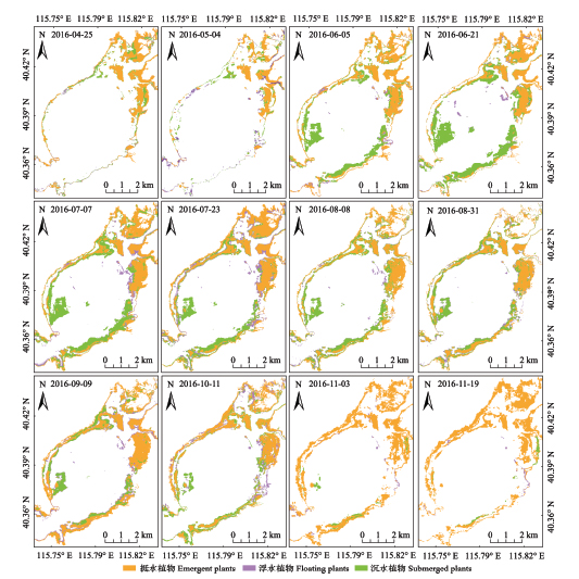
光谱特征变量的筛选作为水生植物识别的重要手段之一, 在水生植物种类识别研究中应用广泛。该研究将实测光谱特征提取与多时相Landsat 8 OLI影像数据分析相结合, 找到一种有效识别不同种类水生植物的特征变量。在水生植物反射光谱特征分析中引入矿质分析中普遍使用的连续统去除法, 对光谱重采样结果作连续统去除处理后提取光谱吸收深度特征。采用单因素方差分析法对比7个光谱重采样波段和3个连续统去除吸收深度敏感波段, 发现经连续统去除处理的短波红外1波段(SWIR1CR)对于不同类型的水生植物区分效果最佳。将连续统去除法应用到遥感影像处理上, 发现SWIR1CR波段能较好区分沉水植物和挺水植物; 结合影像归一化植被指数和SWIR1CR波段可较好区分三类水生植物。结合特征波段筛选结果采用支持向量机分类方法, 得到水生植物的分类结果精度为86.33%, 对比全生长期12期影像提取的水生植物分布图, 发现水生植物主要分布于官厅水库库区南北岸浅水区, 水生植物面积最大时约占库区总面积的35.13%; 其中沉水植物年内生长分布变化幅度较大, 6月上旬开始迅速生长; 10月份水生植物开始衰减; 11月份水生植物占库区面积的20%, 沉水、浮水植物大幅衰减消失。
汪星, 宫兆宁, 井然, 张磊, 金点点 . 基于连续统去除法的水生植物提取及其时空变化分析——以官厅水库库区为例[J]. 植物生态学报, 2018 , 42(6) : 640 -652 . DOI: 10.17521/cjpe.2017.0240
Aims Screening of spectral characteristic variables is one of the important means for aquatic plant recognition, and it is widely applied in aquatic plant species identification. In this paper, a method for identifying aquatic plants species was constructed by combining extracted spectral feature information with the multi-temporal Landsat 8 OLI image data analysis.
Methods In analyzing reflectance spectra of aquatic plants, the method of continuum removal for mineral analysis was introduced. The spectral resampling was performed on the measured spectral curve, and the spectral absorption depth was characterized by the continuous removal of the spectral resampling results. One-way ANOVA method was used to compare the seven spectral resampling bands and the three continuum removal absorption depth sensitive bands. Then the characteristic bands with significant differentiation of different aquatic plants were selected. The continuum removal was applied on remote sensing image processing. The results of the spectroscopic analysis were used to guide the identification of aquatic plants in using Landsat 8 OLI. The classification of aquatic plants was carried out by using support vector machine (SVM) classification.
Important findings The results of the measured spectrum resampling are similar to the atmospheric calibration of Landsat 8 OLI in the same position, and the results of the measured spectral curves can be used to guide the classification of Landsat 8 OLI. The one-way ANOVA method was used to compare seven spectral resampling bands and three continuous systems in absorbing sensitive wavelengths. The results showed that the short wave infrared 1 band, which was processed by continuum removal (SWIR1CR), was the best in distinguishing different types of aquatic plants. In this paper, the continuum removal was applied on remote sensing image processing, and it was found that the SWIR1CR band can better distinguish the submerged plants and the emergent plants. The normalized differential vegetation index and SWIR1CR band were well capable of identifying submerged plants, floating plants and emergent plants. Based on the SVM classification method, the classification accuracies of aquatic plants were 86.33%. The distribution of aquatic plants showed that the aquatic plants were mainly distributed in shallow water areas of the south north bank of Guanting reservoir. When the aquatic plant distribution area reached the peak, it accounted for about 35.13% of the total area of the reservoir. The growth distribution of submerged plants changed significantly during a year. The stem and leaves of submerged plants began to emerge in early June. Aquatic plants began to wither in October, and aquatic plants accounted for only 20% of the total area in November.
| [1] | Brown M, Lewis HG, Gunn SR ( 2000). Linear spectral mixture models and support vector machines for remote sensing. IEEE Transactions on Geoscience & Remote Sensing, 38, 2346-2360. |
| [2] | Carter GA ( 1993). Responses of leaf spectral reflectance to plant stress. American Journal of Botany, 80, 239-243. |
| [3] | Chen W, Hu D, Fu BQ, Gong ZN, Gao W, Hong JM, Du GS ( 2007). Study on Wetland Biodiversity in Beijing. Science Press,Beijing. 46-58. |
| [3] | [ 陈卫, 胡东, 付必谦, 宫兆宁, 高武, 洪剑明, 杜桂森 ( 2007). 北京湿地生物多样性研究. 科学出版社,北京. 46-58.] |
| [4] | Cooley T, Anderson GP, Felde GW, Hoke ML ( 2002). FLAASH, a MODTRAN4-Based Atmospheric Correction Algorithm, its application and validation. IEEE, Toronto, Canada. DOI: 10.1109/IGARSS.2002.1026134. |
| [5] | Du GS, Wang JT, Zhang WH, Feng LQ, Liu J ( 2004). On the nutrient status of Guanting Reservoir. Journal of Lake Sciences, 16, 277-281. |
| [5] | [ 杜桂森, 王建厅, 张为华, 冯伶亲, 刘静 ( 2004). 官厅水库水体营养状况分析. 湖泊科学, 16, 277-281.] |
| [6] | Foody GM, Mathur A ( 2004). A relative evaluation of multiclass image classification by support vector machines. IEEE Transactions on Geoscience & Remote Sensing, 42, 1335-1343. |
| [7] | Guyon I, Weston J, Barnhill S, Vapnik V ( 2002). Gene selection for cancer classification using support vector machines. Machine Learning, 46, 389-422. |
| [8] | He TJ ( 1989). Water Environment Indicators. China Environmental Science Press, Beijing. |
| [8] | [ 合田健 ( 1989). 水环境指标. 中国环境科学出版社,北京.] |
| [9] | Jia P, Li HT, Lin H, Gu HY, Han YS ( 2008). Research on multi-source remote sensing image classification based on SVM. Science of Surveying and Mapping, 33(4), 21-22. |
| [9] | [ 贾萍, 李海涛, 林卉, 顾海燕, 韩颜顺 ( 2008). 基于SVM的多源遥感影像分类研究. 测绘科学, 33(4), 21-22. ] |
| [10] | Li CJ, Liu LY, Wang JH, Wang RC ( 2004). Comparison of two methods of fusing remote sensing images with fidelity of spectral information. Journal of Image & Graphics, 9, 1376-1385. |
| [10] | [ 李存军, 刘良云, 王纪华, 王人潮 ( 2004). 两种高保真遥感影像融合方法比较. 中国图象图形学报, 9, 1376-1385.] |
| [11] | Li JS, Wu D, Wu YF, Liu HX, Shen Q, Zhang H ( 2009). Identification of algae-bloom and aquatic macrophytes in Lake Taihu from in-situ measured spectra data. Journal of Lake Sciences, 21, 215-222. |
| [11] | [ 李俊生, 吴迪, 吴远峰, 刘海霞, 申茜, 张浩 ( 2009). 基于实测光谱数据的太湖水华和水生高等植物识别. 湖泊科学, 21, 215-222.] |
| [12] | Li Y, Zhang LF, Huang CP, Wang JN, Cen Y ( 2016). Monitor of cyanobacteria bloom in Lake Taihu from 2001 to 2013 based on MODIS temporal spectral data. Spectroscopy and Spectral Analysis, 36, 1406-1411. |
| [12] | [ 李瑶, 张立福, 黄长平, 王晋年, 岑奕 ( 2016). 基于MODIS植被指数时间谱的太湖2001年—2013年蓝藻爆发监测. 光谱学与光谱分析, 36, 1406-1411.] |
| [13] | Lin C, Gong ZN, Zhao WJ ( 2010). The extraction of wetland hydrophytes types based on medium resolution TM data. Acta Ecologica Sinica, 30, 6460-6469. |
| [13] | [ 林川, 宫兆宁, 赵文吉 ( 2010). 基于中分辨率TM数据的湿地水生植被提取. 生态学报, 30, 6460-6469.] |
| [14] | Lin C, Gong ZN, Zhao WJ ( 2011). Hyperspectral estimation models for plant community water content at both leaf and canopy levels in Wild Duck Lake wetland. Acta Ecologica Sinica, 31, 6645-6658. |
| [14] | [ 林川, 宫兆宁, 赵文吉 ( 2011). 叶冠尺度野鸭湖湿地植物群落含水量的高光谱估算模型. 生态学报, 31, 6645-6658.] |
| [15] | Lin C, Gong ZN, Zhao WJ, Fan L ( 2013). Identifying typical plant ecological types based on spectral characteristic variables: A case study in Wild Duck Lake wetland, Beijing. Acta Ecologica Sinica, 33, 1172-1185. |
| [15] | [ 林川, 宫兆宁, 赵文吉, 樊磊 ( 2013). 基于光谱特征变量的湿地典型植物生态类型识别方法——以北京野鸭湖湿地为例. 生态学报, 33, 1172-1185.] |
| [16] | Liu K, Zhao WJ, Guo XY, Hu DY, Gong ZN, Long J ( 2010). Spectral bands of typical wetland vegetation in the Wild Duck Lake. Acta Ecologica Sinica, 30, 5853-5861. |
| [16] | [ 刘克, 赵文吉, 郭逍宇, 胡德勇, 宫兆宁, 龙娟 ( 2010). 野鸭湖典型湿地植物光谱特征. 生态学报, 30, 5853-5861.] |
| [17] | Meer FVD ( 2004). Analysis of spectral absorption features in hyperspectral imagery. International Journal of Applied Earth Observation & Geoinformation, 5, 55-68. |
| [18] | Oyama Y, Fukushima T, Matsushita B, Matsuzaki H, Kamiya K, Kobinata H ( 2015). Monitoring levels of cyanobacterial blooms using the visual cyanobacteria index (VCI) and floating algae index (FAI). International Journal of Applied Earth Observations & Geoinformation, 38, 335-348. |
| [19] | Schmidt KS, Skidmore AK ( 2003). Spectral discrimination of vegetation types in a coastal wetland. Remote Sensing of Environment, 85, 92-108. |
| [20] | Shi H, Li XW, Niu ZC, Li JY, Li Y, Li N ( 2016). Remote sensing information extraction of aquatic vegetation in Lake Taihu based on Random Forest Model. Journal of Lake Sciences, 28, 635-644. |
| [20] | [ 侍昊, 李旭文, 牛志春, 李继影, 李杨, 李宁 ( 2016). 基于随机森林模型的太湖水生植被遥感信息提取. 湖泊科学, 28, 635-644.] |
| [21] | Tang JW, Tian GL, Wang XY, Wang XM, Song QJ ( 2004). The methods of water spectra measurement and analysis I: Above-water method. Journal of Remote Sensing, 8, 37-44. |
| [21] | [ 唐军武, 田国良, 汪小勇, 王晓梅, 宋庆君 ( 2004). 水体光谱测量与分析I: 水面以上测量法. 遥感学报, 8, 37-44.] |
| [22] | Tian YC, Cao WX, Jiang D, Zhu Y, Xue LH ( 2005). Relationship between canopy reflectance and plant water content in rice under different soil water and nitrogen conditions. Acta Phytoecologica Sinica, 29, 318-323. |
| [22] | [ 田永超, 曹卫星, 姜东, 朱艳, 薛利红 ( 2005). 不同水氮条件下水稻冠层反射光谱与植株含水率的定量关系. 植物生态学报, 29, 318-323.] |
| [23] | Ungar SG, Pearlman JS, Mendenhall JA, Reuter D ( 2003). Overview of the earth observing one (EO-1) mission. IEEE Transactions on Geoscience and Remote Sensing, 41, 1149-1159. |
| [24] | Vapnik V, Golowich SE, Smola A ( 1997). Support vector method for function approximation, regression estimation, and signal processing. Advances in Neural Information Processing Systems, 9, 281-287. |
| [25] | Wang TT, Li SS, Li A, Feng XX, Wu YW ( 2015). Land cover classification in Beijing using Landsat 8 image. Journal of Image and Graphics, 20, 1275-1284. |
| [25] | [ 王婷婷, 李山山, 李安, 冯旭祥, 吴业炜 ( 2015). 基于Landsat 8卫星影像的北京地区土地覆盖分类. 中国图象图形学报, 20, 1275-1284.] |
| [26] | Wang X, Zhang F, Hsiang-Te K, Yu H ( 2017). Spectral response characteristics and identification of typical plant species in Ebinur lake wetland national nature reserve (ELWNNR) under a water and salinity gradient. Ecological Indicators, 81, 222-234. |
| [27] | Wetzel RG ( 1983). Limnology. 3rd ed. Academic Press, Cambridge, USA. |
| [28] | Wu ZB ( 2011). Aquatic Plants and Water Ecological Restoration. Science Press, Beijing. |
| [28] | [ 吴振斌 ( 2011). 水生植物与水体生态修复. 科学出版社,北京.] |
| [29] | Xu DL, Zhang DD, Zhang CY, Wan L, Han BP ( 2013). Distribution and change of macrophytes in Luoma Lake for 3 periods. Wetland Science, 11, 320-325. |
| [29] | [ 徐德兰, 张东东, 张翠英, 万蕾, 韩宝平 ( 2013). 3个时期骆马湖大型水生植物的分布及变化. 湿地科学, 11, 320-325.] |
| [30] | Xu JX ( 2009). Wetland Plants in Beijing. Beijing Science and Technology Press, Beijing. |
| [30] | [ 徐景先 ( 2009). 北京湿地植物. 北京科学技术出版社,北京.] |
| [31] | Xue W ( 2013). SPSS Statistical Analysis Method and Application. Electronic Industry Press, Beijing. |
| [31] | [ 薛薇 ( 2013). SPSS统计分析方法及应用. 电子工业出版社,北京.] |
| [32] | Yang QX ( 1998). Ecological functions of aquatic vegetation in East Taihu Lake and its reasonable regulation. Journal of Lake Sciences, 10, 67-72. |
| [32] | [ 杨清心 ( 1998). 东太湖水生植被的生态功能及调节机制. 湖泊科学, 10, 67-72.] |
| [33] | You HL, Xu LG, Liu GL, Wu YM, Liu LZ, Jiang JH ( 2016). Change of wetland landscape at Poyang Lake and its response to water level fluctuation. Chinese Journal of Ecology, 35, 2487-2493. |
| [33] | [ 游海林, 徐力刚, 刘桂林, 吴永明, 刘丽贞, 姜加虎 ( 2016). 鄱阳湖湿地景观类型变化趋势及其对水位变动的响应. 生态学杂志, 35, 2487-2493.] |
| [34] | Yu HY, Yan BK, Gan FP, Chi WX, Wu FD ( 2007). Hyperspectral image fusion by an enhanced Gram Schmidt spectral transformation. Geography and Geo-Information Science, 23(5), 39-42. |
| [34] | [ 于海洋, 闫柏琨, 甘甫平, 迟文学, 武法东 ( 2007). 基于Gram Schmidt变换的高光谱遥感图像改进融合方法. 地理与地理信息科学, 23(5), 39-42.] |
| [35] | Yuan BY ( 2000). Analysis of water quality status and tendency of Guanting Reservoir. Beijing Water, ( 5), 29-31. |
| [35] | [ 袁博宇 ( 2000). 官厅水库水质现状及趋势分析. 北京水务, ( 5), 29-31.] |
| [36] | Yuan JG, Niu Z, Wang XP ( 2009). Atmospheric correction of Hyperion hyperspectral image based on FLAASH. Spectroscopy and Spectral Analysis, 29, 1181-1185. |
| [36] | [ 袁金国, 牛铮, 王锡平 ( 2009). 基于FLAASH的Hyperion高光谱影像大气校正. 光谱学与光谱分析, 29, 1181-1185.] |
| [37] | Zhang M ( 2010). Spectral indices for estimating ecological indicators of karst rocky desertification. International Journal of Remote Sensing, 31, 2115-2122. |
| [38] | Zhang SX, Duan HT, Gu XH ( 2008). Remote sensing information extraction of hydrophytes based on the retrieval of water transparency in Lake Taihu. Journal of Lake Sciences, 20, 184-190. |
| [38] | [ 张寿选, 段洪涛, 谷孝鸿 ( 2008). 基于水体透明度反演的太湖水生植被遥感信息提取. 湖泊科学, 20, 184-190.] |
| [39] | Zhen Z, Gong ZN, Zhao WJ ( 2012). Analysis of hydrophytes for spatial evolution pattern in Guanting Reservoir, China. Journal of Agro-Environment Science, 31, 1586-1595. |
| [39] | [ 甄姿, 宫兆宁, 赵文吉 ( 2012). 官厅水库库区水生植物演变格局时空变化特征分析. 农业环境科学学报, 31, 1586-1595.] |
| [40] | Zheng XM, Ding YL, Zhao K, Jiang T, Li XF, Zhang SY, Li YY, Wu LL, Sun J, Ren JH, Zhang XX ( 2014). Estimation of vegetation water content from Landsat 8 OLI data. Spectroscopy and Spectral Analysis, 34, 3385-3390. |
| [40] | [ 郑兴明, 丁艳玲, 赵凯, 姜涛, 李晓峰, 张世轶, 李洋洋, 武黎黎, 孙建, 任建华, 张宣宣 ( 2014). 基于Landsat 8 OLI数据的玉米冠层含水量反演研究. 光谱学与光谱分析, 34, 3385-3390.] |
| [41] | Zhu XL, Zhang H, Lei P, Zhang BZ, Shan BQ, Shi MW ( 2016). Historical distribution characteristics of major elements in Guanting Reservoir sediment. Acta Scientiae Circumstantiae, 36, 442-449. |
| [41] | [ 朱晓磊, 张洪, 雷沛, 张伯镇, 单保庆, 史密伟 ( 2016). 官厅水库沉积物中大量元素的历史分布特征. 环境科学学报, 36, 442-449.] |
| [42] | Zou WN, Yuan L, Zhang LQ, Chen WY ( 2012). Impacts of coverage and canopy water depth on the spectral characteristics for a submerged plant Cabomba caroliniana. Acta Ecologica Sinica, 32, 706-714. |
| [42] | [ 邹维娜, 袁琳, 张利权, 陈万逸 ( 2012). 盖度与冠层水深对沉水植物水盾草光谱特性的影响. 生态学报, 32, 706-714.] |
/
| 〈 |
|
〉 |
