


图1
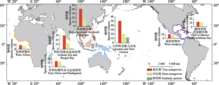
图1
环南海区域和全球其他区域的红树物种多样性比较。
Fig. 1
Comparison of mangrove species richness between the region around the South China Sea and other regions.
环南海区域位于印度-西太平洋区红树植物的中心地带, 是围绕中国南海的岛屿、半岛及大陆边缘所形成的半封闭地理单元(李欣, 2017; 金凤君等, 2021), 也是我国南方与东南亚植物区系直接联系的地带。环南海区域拥有极高的红树植物物种多样性(林鹏, 1987; 廖宝文和张乔民, 2014), 但由于这一区域地质历史复杂(谭珂等, 2020)、更新世气候变化导致海平面波动明显(Voris, 2000)、洋流复杂多变(Fang et al., 2012), 并受南亚季风、东亚季风、西北太平洋季风三大季风的共同影响(姜超等, 2017), 环南海区域红树植物的地理分布格局与扩散历史非常复杂。针对环南海区域进行红树植物物种多样性分布格局及迁移历史的研究, 有助于解析红树植物及类似海漂植物的长距离扩散路线及形成机制, 有助于揭示洋流、季风及重大地质历史事件等对东南亚和中国南部植物多样性分布及演化的作用, 有助于解释全球气候变化对红树植物分布与变迁的影响趋势。
本研究将环南海区域分为华南沿海地区、台湾岛、海南岛、中南半岛、马来半岛、加里曼丹岛(婆罗洲)、巴拉望岛、吕宋岛等8个地区(图1)。通过文献调研, 首先明确这8个地区的红树植物物种数量分布格局; 然后结合该区域内主要红树植物种群遗传结构和迁移历史的研究结果, 分析环南海区域红树物种的长距离扩散路线; 最后根据红树物种生物学特性及系统进化历史, 结合季风、洋流以及冰期海平面变化等重大地质事件, 解析环南海区域红树植物多样性分布格局及形成机制。
1 材料和方法
1.1 物种数量
1.2 地理分布格局
为进一步准确揭示红树物种在环南海区域的物种多样性分布格局, 选取物种数量较多的红树科、锦葵科、海桑属(Sonneratia)、海榄雌属(Avicennia) 4个典型红树类群, 利用DIVA-GIS 7.5.0构建1° × 1°物种数量的分布图, 确定物种分布格局与物种多样性分布中心。
1.3 迁移历史与路线
使用关键词“dispersal” “genetic” “South China Sea” “mangrove”, 在ISI Web of Science中检索文献。根据检索到的文献, 总结红树物种在环南海区域的种群遗传关系、迁移路线与方向等。
2 结果
2.1 红树物种多样性
环南海区域自然分布的红树植物共有53种, 分属于23科31属; 其中真红树植物15科19属39种, 半红树植物10科12属14种(附录I)。环南海区域20%以上的红树物种属红树科, 其次是海桑科, 且均为真红树植物。环南海区域的红树物种多样性仅次于邻近的大洋洲及新几内亚(68种), 远高于阿拉伯海及孟加拉湾(42种)、非洲东海岸及马达加斯加(28种)、墨西哥湾及加勒比海(22种)、美洲西海岸(即从北美洲南部、中美洲直到南美洲北部的太平洋沿岸, 16种)、非洲西海岸(15种) (图1)。环南海区域和邻近的大洋洲及新几内亚、阿拉伯海及孟加拉湾同属红树林植物区系的印度-西太平洋区, 优势物种以红树科、海桑属、海榄雌属植物为主。大西洋-东太平洋区(墨西哥湾及加勒比海、美洲西海岸、非洲西海岸)的红树物种多样性明显低得多(图1), 主要以海榄雌属植物为优势种。
2.2 地理分布格局
根据物种多样性的地理分布来看, 环南海区域红树物种最富集的地方主要在马来半岛、中南半岛的泰国湾、加里曼丹岛、海南岛等4个地方(图2)。马来半岛是环南海区域红树物种多样性最高的地区, 分布有红树植物45种, 其中真红树34种; 而巴拉望岛则是环南海区域红树物种数最少的地方, 仅有21种(真红树11种)。
图2
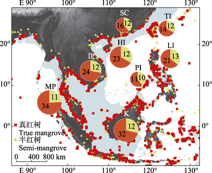
图2
环南海区域红树物种多样性分布格局。饼图大小对应红树物种数量。分布点数据来源于Global Biodiversity Information Facility (GBIF)网站(
Fig. 2
Distribution pattern of mangrove species around the South China Sea. The pie size corresponds to species richness. Data obtained from Global Biodiversity Information Facility (GBIF,
加里曼丹岛地处环南海区域的南端, 是该区域最大的岛屿。该岛红树物种共计44种(32种真红树, 12种半红树), 红树物种多样性仅次于马来半岛。
吕宋岛位于环南海区域东侧, 位于南海和太平洋之间, 与相邻的巴拉望岛和台湾岛相比, 具有更高的红树物种多样性: 真红树物种21种, 半红树13种。
海南岛位于环南海区域西侧偏北部, 分布有红树物种35种(含真红树23种), 是环南海区域北部的红树物种多样性分布中心。
台湾岛地处环南海区域的东北, 分布有26种红树植物, 其中真红树14种, 半红树12种。
华南沿海地区包括了广西、广东及福建南部的海岸带, 分布有红树植物28种(真红树16种, 半红树12种)。
2.3 红树物种分布中心
综合红树科、锦葵科、海桑属、海榄雌属的物种多样性地理分布格局来看, 环南海区域的红树植物集中分布在加里曼丹岛东北端、马来半岛、海南岛、中南半岛的泰国湾等地(图3), 主要位于环南海区域的南部和西部。
图3
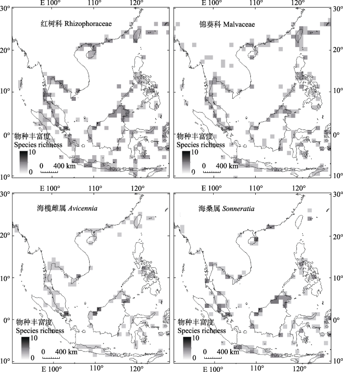
图3
环南海区域4个典型红树植物类群的地理分布。数据来源于Global Biodiversity Information Facility (GBIF)网站(
Fig. 3
Species distribution pattern of four typical mangrove taxa around the South China Sea. Data obtained from Global Biodiversity Information Facility (GBIF) (
2.4 迁移历史与路线
本研究共检索到涉及环南海区域的红树物种迁移的文献18篇, 涉及杯萼海桑(Sonneratia alba)、榄李(Lumnitzera racemosa)、海漆(Excoecaria agallocha)等16个物种。果期在夏季的红树如海漆、榄李、红榄李(Lumnitzera littorea)、木果楝(Xylocarpus granatum)、蜡烛果(Aegiceras corniculatum)、黄槿(Talipariti tiliaceus)、老鼠簕(Acanthus ilicifolius)等, 主要是在南亚季风和南海洋流的作用下, 由南向北扩散(Takayama et al., 2008; Tomlinson, 2016; Tomizawa et al., 2017; Guo et al., 2018a, 2020, 2021; Zhang et al., 2022); 而果期在秋冬季的红树如海桑(Sonneratia caseolaris)、杯萼海桑、角果木(Ceriops tagal)、银叶树(Heritiera littoralis)主要是在冬季风和由北向南的洋流作用下, 由北向南扩散(Liao et al., 2007; Yang et al., 2016, 2017; Wee et al., 2017; Banerjee et al., 2020)。果期全年的红树如红茄苳(Rhizophora mucronata)、红海兰(Rhizophora stylosa)、红树(Rhizophora apiculata)、木榄(Bruguiera gymnorhiza)、秋茄树(Kandelia obovata)可能同时受到了这两个方向的长距离扩散影响, 在夏季和冬季都发生过长距离扩散(Urashi et al., 2013; Ng et al., 2015; Guo et al., 2016)。
3 讨论
3.1 物种多样性分布格局形成的原因
环南海区域共分布有红树物种23科31属53种, 其中真红树植物39种。这与全球红树林分布区域的红树物种多样性相比是偏高的(图1)。
环南海区域红树物种数量最多的地区是位于南部的马来半岛(45种)和加里曼丹岛(44种), 其次是中南半岛(36种), 位于环南海区域北部的海南岛(35种)以及位于南海与太平洋之间的吕宋岛(34种) (图2)。特别是加里曼丹岛的东北端、中南半岛的泰国湾、海南岛这3个地点是红树物种最为富集的地方(图2, 图3), 马来半岛东临南海, 西朝印度洋, 被广泛认为是红树植物扩散的天然屏障(He et al., 2019), 这也使得马来半岛可同时接受南海(太平洋)和印度洋的红树植物。另外, 马来半岛与苏门答腊岛隔着浅浅的马六甲海峡相望, 苏门答腊岛的红树植物可以很容易扩散到马来半岛, 在一定程度上也丰富了马来半岛的红树植物组成。
巴拉望岛是整个环南海区域红树物种最少的地方, 这可能是因为巴拉望岛面积小, 且全岛形状狭长, 缺少河流; 海岸多喀斯特石山与悬崖, 缺乏红树植物适宜生长的河口和滩涂。华南沿海地区和台湾岛较低的红树物种数量, 可能主要是因为这两地纬度较高, 冬季低温环境不适宜大多数红树植物的生长。
3.2 历史迁移路线
红树植物起源于白垩纪晚期的古特提斯海岸, 在早始新世分化出红树属、水椰属(Nypa)、海桑属、秋茄树属、木榄属、海榄雌属、角果木属和榄李属(Ellison et al., 1999)。大约在始新世中期(距今4 000万年前), 红树科及海桑属植物从特提斯海向北扩散至如今的环南海区域(Plaziat et al., 2001; Duke et al., 2002; 王瑞江和陈忠毅, 2002)。大部分红树植物的果实或种子能漂浮在海面, 随波逐流(van der Stocken et al., 2015; Tomlinson, 2016)。这个过程受到洋流和季风的极大影响, 呈现出在夏季、冬季的不同扩散路线与方向。
3.2.1 夏季扩散路线
海漆、榄李、红榄李、木果楝、蜡烛果、黄槿、老鼠簕的果期主要在夏季(Tomlinson, 2016), 而夏季的南海洋流在南亚季风的作用下, 主要由南向北流动(图4)。因此, 这些物种的长距离扩散主要由南向北; 特别是印度洋暖流由卡里马塔海峡进入南海南端后形成两个分支, 一支靠西侧沿马来半岛流向中南半岛, 并在泰国湾形成环流; 另一支靠东侧沿加里曼丹岛、巴拉望岛、吕宋岛进入巴士海峡(Fang et al., 2012)。这两条洋流促进了红树植物由南向北的长距离扩散。另一方面, 起始于海南岛东南部的洋流沿海南岛与穿越琼州海峡的北部湾洋流汇合, 一并沿华南沿海地区流向台湾海峡, 形成了南海北部的小范围洋流。在这一南一北洋流的作用下, 一些红树物种在环南海区域的种群被分为南部谱系、北部谱系, 谱系间的亲缘关系较为疏远, 谱系内的基因交流较为紧密(Takayama et al., 2008; Tomizawa et al., 2017; Guo et al., 2018a, 2018b, 2020, 2021; Zhang et al., 2022)。
图4
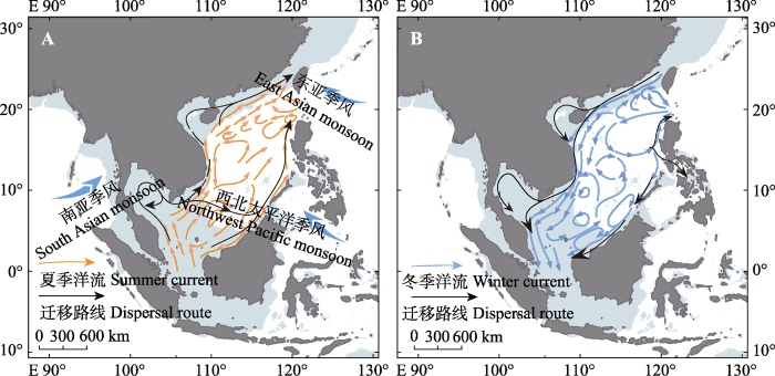
图4
环南海区域夏季(A)和冬季(B)的红树植物扩散路线。浅灰色部分是末次盛冰期(约600万年前)海平面下降120 m后的出露陆地(Voris, 2000)。A图中的虚线表示物种迁移发生几率较低。洋流模式修改自Fang等(2012)。
Fig. 4
Main dispersal routes of mangrove plants around the South China Sea in summer (A) and winter (B). The light gray areas indicate the emerged lands in the Last Glacial Maximum (about 6 million years ago) when the sea level decreased 120 m (Voris, 2000). The dash line in A indicates limited species dispersal in the history. Ocean current patterns modified from Fang et al. (2012).
不过, 南北谱系划分并不适用于所有物种。木果楝、老鼠簕的海南岛种群与泰国湾种群的遗传结构存在着较高相似性(Tomizawa et al., 2017; Guo et al., 2020)。这暗示着木果楝、老鼠簕的繁殖体能够突破洋流对冲、生境缺乏等扩散屏障。这可能得益于它们的成熟果实具有极强的耐盐能力, 保障了种子在经历长距离洋流漂浮之后还能保持活性(Duke, 2006)。海漆的泰国湾种群与加里曼丹岛、巴拉望岛种群的遗传结构非常相近(Guo et al., 2018a), 这表明南海夏季洋流也出现了东西方向的流动(图4A), 通过中南半岛与加里曼丹岛间的环流相联通, 构建起了一条特殊的由中南半岛向加里曼丹岛、巴拉望岛的红树植物迁移路线(Guo et al., 2018a, 2018b, 2018c; 图4)。
3.2.2 冬季扩散路线
海桑、杯萼海桑、角果木果期主要在冬季, 银叶树果期在秋冬季(Tomlinson, 2016), 这些红树植物在环南海区域内的长距离扩散主要受南海冬季洋流的影响。分子生物地理学研究结果表明, 海桑和角果木在环南海区域西侧的海南岛、中南半岛、马来半岛种群的遗传关系更近, 而加里曼丹岛、吕宋岛、巴拉望岛等地的种群相对独立(Liao et al., 2007; Yang et al., 2016, 2017; Wee et al., 2017; Banerjee et al., 2020)。在冬季, 有两股洋流分别从台湾海峡和巴士海峡进入南海, 前者沿华南沿海地区、海南岛、中南半岛流向马来半岛, 促进环南海区域西侧红树植物种群的基因交流; 后者进入南海后形成大的环流, 最终沿吕宋岛沿岸折回(Fang et al., 2012)。该洋流不仅对台湾岛和吕宋岛间的红树植物扩散起到了阻隔作用, 还使吕宋岛红树植物形成了南部向南、北部向北的特殊扩散方向(图4B)。另外, 起始于吕宋岛南部的洋流, 沿巴拉望岛和加里曼丹岛, 最终流出环南海区域, 这一洋流状态极为复杂, 在巴拉望岛和加里曼丹岛多次出现向北折返(Fang et al., 2012), 该洋流促进了加里曼丹岛东北端和巴拉望岛地区内部的红树植物扩散, 抑制了与其他地区之间的红树植物扩散。因此, 吕宋岛、巴拉望岛、加里曼丹岛3地红树植物的遗传谱系相对独立。
还有一些全年果期的红树植物, 可能在冬季和夏季都发生过长距离扩散事件。如红树科的红茄苳、红海兰、红树、木榄、秋茄树几乎全年果期(Tomlinson, 2016)。这些红树植物在环南海区域内的长距离扩散, 既受夏季洋流和南亚季风的作用, 也受到冬季洋流的影响。分子生物地理学研究结果表明, 这些红树植物的种群间基因流更为紧密, 长距离扩散水平较高(Urashi et al., 2013; Wee et al., 2015; Guo et al., 2016), 甚至红茄苳和红海兰的扩散能突破马来半岛的地理隔离(Ng et al., 2015), 分布到马来半岛西侧、印度洋沿岸。另一方面, 这些红树物种不仅具有丰富的基因单倍型, 还有着较高的种群遗传相似度, 说明环南海区域存在多个冰期避难所, 保留下了较多的单倍型, 且发生过冰期后的长距离扩散和较高水平的基因流(Urashi et al., 2013; Ng et al., 2015; Guo et al., 2016)。
3.3 历史迁移路线的发生机制
3.3.1 季风与洋流
环南海区域内的洋流状况复杂, 既受到夏季和冬季不同方向的季风影响, 也受印度洋和太平洋洋流的共同影响; 而南海复杂的海岸带地形地貌也加剧了洋流方向与强度的变化程度。总体上, 洋流对环南海区域红树植物长距离扩散的促进作用是一定的, 不过对同一时间的不同地区, 同一地区在不同时间, 以及对不同物种来说, 复杂的洋流状态可能产生不同的影响。比如在中南半岛(越南沿海)地区的夏季洋流阻碍了部分红树植物的扩散, 冬季洋流在巴拉望岛、吕宋岛两侧形成了海上扩散屏障(图4)。
环南海区域内季风盛行, 华南沿海地区、台湾岛主要受东亚季风影响, 吕宋岛、巴拉望岛主要受西北太平洋季风影响, 中南半岛、海南岛、马来半岛北部则是受东亚季风、南亚季风、西北太平洋季风三者叠加影响(姜超等, 2017)。毫无疑问, 季风对南海洋流特别是表层洋流的流动状态造成影响, 以及对红树植物繁殖体的海上漂流起直接推动作用。季风更是环南海区域大部分地区产生降水的重要气候条件, 如海南岛、中南半岛、华南沿海地区等对湿润季风形成有效拦截, 生成了昌化江、南渡江、湄南河、湄公河、珠江等发达的水系, 这些河流与海洋交汇处则是红树植物理想的生长环境(Tomlinson, 2016)。另外, 季风还对环南海区域红树林的碳环境、水环境、生物群落结构等产生直接影响(Canini et al., 2013)。
3.3.2 重大地质历史事件
红树植物可能起源于白垩纪晚期的北方劳亚古陆和南方冈瓦纳古陆之间的“古地中海”; 在侏罗纪中期到中新世早期的古热带赤道洋流推动下, 逐渐抵达今天的印度-西太平洋区(Ellison et al., 1999)。已有研究认为, 古地中海的封闭改变了整个印度洋环流, 秋茄树属被限制在今天的环南海区域, 并演化成Kandelia candel和K. obovata 2个物种(Chiang et al., 2001; Sheue et al., 2003)。因此, 环南海区域可能是红树科植物从古地中海向太平洋区域迁移的祖先分布区, 是整个太平洋地区红树科植物最原始种群的分布地(Duke et al., 2002)。
3.3.3 红树植物的自身特性
植物繁殖体的有效扩散决定了物种的分布(Lester et al., 2007)。红树植物经过了长时间的适应性演化, 不同红树物种成熟繁殖体的结构状态不同, 长距离扩散能力有所差异(van der Stocken et al., 2015)。红树科植物均产生胎生种子, 具有低密度、可随洋流扩散、扩散完成后还可快速生根等适应性特征。海桑属红树植物果实包含多颗种子, 成熟果实在漂流过程中逐渐腐烂, 种子得以被逐渐释放(Wee et al., 2017)。海漆成熟种子中还留有空腔, 进一步增强了种子的浮力(Das et al., 2011)。榄李属果实较小, 银叶树属果实较大, 虽然大小不同, 但两者均采用富含纤维组织的种皮对种子进行包裹, 供种子完成漂浮(Ye et al., 2004)。木果楝属红树植物果实硕大, 形如炮弹, 内含大粒种子2-3枚, 果实成熟后质地轻盈, 在漂浮过程中受风的推动作用最为明显(Duke, 2006)。
红树物种对盐分和温度的耐受性, 也在很大程度上影响到了红树物种的地理分布格局。海桑属作为低潮间带生长的标志性红树植物, 其中的杯萼海桑分布范围最为广泛, 耐盐程度也最高(Alongi, 2002), 高盐分耐受能力为杯萼海桑的长距离扩散和广泛分布奠定了基础。红树属的红海兰和红茄苳能够忍耐冬季低温, 广泛分布于华南沿海、台湾岛, 甚至更北的琉球群岛; 而红树最北只能分布于海南岛及雷州半岛附近(Duke et al., 2002)。秋茄树属的Kandelia candel在热带及亚热带均有分布, 而K. obovata主要分布在亚热带, 可能是后期适应亚热带地区逐渐分化出来的物种(Sheue et al., 2003)。榄李属的物种也能耐受一定的低温, 如红榄李和榄李最北能够分布到海南岛、台湾岛一带(Guo et al., 2021)。
红树物种的分布格局与系统进化历史也密切相关。红树属、角果木属、秋茄树属、木榄属、木果楝属、海桑属、海榄雌属、玉蕊属(Barringtonia)等的物种分化时间集中发生在更新世(He et al., 2019, 2022), 这一演化历史无疑是影响如今红树物种分布格局的重要因素。He等(2022)针对热带地区32种红树林的全基因组测序研究发现, 热带地区红树物种发生过至少27次独立起源(新物种形成), 但南海历史上频繁的海平面上升与下降带来的干扰等也导致了较多红树物种的灭绝, 使得系统发育历史上只表现出中度的净物种形成。秋茄树属是在更新世末期才在今天的环南海区域演化出来, 较短的演化历史使得这个属仅有2个物种(K. candel和K. obovata), 并成为了环南海区域特有的属(Chiang et al., 2001)。Avicennia eucalyptifolia和Camptostemon philippinense在环南海区域仅分布在吕宋岛, 但集中分布于邻近的苏拉威西岛、棉兰老岛、新几内亚岛等地。这表明, 这两个物种很可能是在较晚的时候才扩散到吕宋岛(Primavera et al., 2004; Sarmiento, 2020)。类似地, 广布于澳大利亚及其邻近区域的Osbornia octodonta可能是从澳大利亚扩散到加里曼丹岛和吕宋岛(Saenger et al., 2019)、Acanthus volubilis则是从印度洋通过马六甲海峡扩散到环南海区域的马来半岛(Matos et al., 2022), 极大地丰富了环南海区域的红树物种多样性。
4 结论和展望
环南海区域分布的53种红树植物(真红树39种,半红树14种)集中分布在马来半岛、中南半岛的泰国湾、加里曼丹岛北部及海南岛等地, 巴拉望岛红树植物的物种多样性最低。这种地理分布格局是由特殊的地质地貌和洋流方向决定的。海南岛及邻近地区可能是红树植物在冰期的重要避难所, 因此具有极高的红树物种多样性; 吕宋岛较高的红树物种多样性则主要是因为该岛位于西太平洋、大洋洲和南海之间, 是红树植物长距离扩散的一个交汇地。
季风的作用使得环南海区域红树植物的扩散路径在夏季和冬季存在截然不同的格局。在地质历史上, 末次盛冰期造成南海海平面下降了120 m左右, 极大地影响了南海红树植物地理分布格局与遗传背景。红树物种由于特殊的适应历史和生境特点, 对于全球气候变化和海平面上升的影响更为敏感。
目前已有研究大多针对广布种, 缺乏对环南海区域的特有种及狭域分布种的物种分化机制与迁移历史的深入研究。利用现代分子生物学技术, 尤其是基因组数据, 覆盖整个环南海区域对狭域特有种开展物种迁移与生物地理学研究, 有助于进一步揭示环南海区域红树植物的生物地理学格局及其在全球变化背景下的演变趋势, 值得今后相关研究重视。
附录
附录 环南海区域红树植物物种名录及其基本信息
Supplement Mangrove species and their basic information of the South China Sea
致谢
感谢海南大学姚小兰、金文婷、谭珂、凌少军等在数据分析和写作上的帮助。
参考文献
Present state and future of the world’s mangrove forests
DOI:10.1017/S0376892902000231
URL
[本文引用: 2]

Mangroves, the only woody halophytes living at the confluence of land and sea, have been heavily used traditionally for food, timber, fuel and medicine, and presently occupy about 181 000 km2 of tropical and subtropical coastline. Over the past 50 years, approximately one-third of the world's mangrove forests have been lost, but most data show very variable loss rates and there is considerable margin of error in most estimates. Mangroves are a valuable ecological and economic resource, being important nursery grounds and breeding sites for birds, fish, crustaceans, shellfish, reptiles and mammals; a renewable source of wood; accumulation sites for sediment, contaminants, carbon and nutrients; and offer protection against coastal erosion. The destruction of mangroves is usually positively related to human population density. Major reasons for destruction are urban development, aquaculture, mining and overexploitation for timber, fish, crustaceans and shellfish. Over the next 25 years, unrestricted clear felling, aquaculture, and overexploitation of fisheries will be the greatest threats, with lesser problems being alteration of hydrology, pollution and global warming. Loss of biodiversity is, and will continue to be, a severe problem as even pristine mangroves are species-poor compared with other tropical ecosystems. The future is not entirely bleak. The number of rehabilitation and restoration projects is increasing worldwide with some countries showing increases in mangrove area. The intensity of coastal aquaculture appears to have levelled off in some parts of the world. Some commercial projects and economic models indicate that mangroves can be used as a sustainable resource, especially for wood. The brightest note is that the rate of population growth is projected to slow during the next 50 years, with a gradual decline thereafter to the end of the century. Mangrove forests will continue to be exploited at current rates to 2025, unless they are seen as a valuable resource to be managed on a sustainable basis. After 2025, the future of mangroves will depend on technological and ecological advances in multi-species silviculture, genetics, and forestry modelling, but the greatest hope for their future is for a reduction in human population growth.
Land masses and oceanic currents drive population structure of Heritiera littoralis, a widespread mangrove in the Indo-West Pacific
DOI:10.1002/ece3.6460
PMID:32760533
[本文引用: 3]
Phylogeographic forces driving evolution of sea-dispersed plants are often influenced by regional and species characteristics, although not yet deciphered at a large spatial scale for many taxa like the mangrove species. This study aimed to assess geographic distribution of genetic variation of this widespread mangrove in the Indo-West Pacific region and identify the phylogeographic factors influencing its present-day distribution. Analysis of five chloroplast DNA fragments' sequences from 37 populations revealed low genetic diversity at the population level and strong genetic structure of in this region. The estimated divergence times between the major genetic lineages indicated that glacial level changes during the Pleistocene epoch induced strong genetic differentiation across the Indian and Pacific Oceans. In comparison to the strong genetic break imposed by the Sunda Shelf toward splitting the lineages of the Indian and Pacific Oceans, the genetic differentiation between Indo-Malesia and Australasia was not so prominent. Long-distance dispersal ability of propagules helped the species to attain transoceanic distribution not only across South East Asia and Australia, but also across the Indian Ocean to East Africa. However, oceanic circulation pattern in the South China Sea was found to act as a barrier creating further intraoceanic genetic differentiation. Overall, phylogeographic analysis in this study revealed that glacial vicariance had profound influence on population differentiation in and caused low genetic diversity except for the refugia populations near the equator which might have persisted through glacial maxima. With increasing loss of suitable habitats due to anthropogenic activities, these findings therefore emphasize the urgent need for conservation actions for all populations throughout the distribution range of.© 2020 The Authors. Ecology and Evolution published by John Wiley & Sons Ltd.
Monsoon-influenced phytoplankton community structure in a Philippine mangrove estuary
Phylogeography of Kandelia candel in East Asiatic mangroves based on nucleotide variation of chloroplast and mitochondrial DNAs
Vivipary with precocious seedlings in mangrove plants was thought to be a hindrance to long-range dispersal. To examine the extent of seedling dispersal across oceans, we investigated the phylogeny and genetic structure among East Asiatic populations of Kandelia candel based on organelle DNAs. In total, three, 28 and seven haplotypes of the chloroplast DNA (cpDNA) atpB-rbcL spacer, cpDNA trnL-trnF spacer, and mitochondrial DNA (mtDNA) internal transcribed spacer (ITS) were identified, respectively, from 202 individuals. Three data sets suggested consistent phylogenies recovering two differentiated lineages corresponding to geographical regions, i.e. northern South-China-Sea + East-China-Sea region and southern South-China-Sea region (Sarawak). Phylogenetically, the Sarawak population was closely related to the Ranong population of western Peninsula Malaysia instead of other South-China-Sea populations, indicating its possible origin from the Indian Ocean Rim. No geographical subdivision was detected within the northern geographical region. An analysis of molecular variance (AMOVA) revealed low levels of genetic differentiation between and within mainland and island populations (phiCT = 0.015, phiSC = 0.037), indicating conspicuous long-distance seedling dispersal across oceans. Significant linkage disequilibrium excluded the possibility of recurrent homoplasious mutations as the major force causing phylogenetic discrepancy between mtDNA and the trnL-trnF spacer within the northern region. Instead, relative ages of alleles contributed to non-random chlorotype-mitotype associations and tree inconsistency. Widespread distribution and random associations (chi2 = 0.822, P = 0.189) of eight hypothetical ancestral cytotypes indicated the panmixis of populations of the northern geographical region as a whole. In contrast, rare and recently evolved alleles were restricted to marginal populations, revealing some preferential directional migration.
Genetic variability among male populations of a minor mangrove Excoecaria agallocha L. as evident by chromosome morphology and DNA markers
DOI:10.1007/s13237-011-0027-z URL [本文引用: 1]
Global distribution and genetic discontinuities of mangroves-emerging patterns in the evolution of Rhizophora
DOI:10.1007/s00468-001-0141-7 URL [本文引用: 3]
A world without mangroves?
DOI:10.1126/science.317.5834.41b PMID:17615322 [本文引用: 1]
Origins of mangrove ecosystems and the mangrove biodiversity anomaly
DOI:10.1046/j.1466-822X.1999.00126.x
URL
[本文引用: 3]
1. Mangrove species richness declines dramatically from a maximum in the Indo‐West Pacific (IWP) to a minimum in the Caribbean and Western Atlantic. Explaining this ‘anomalous’ biogeographic pattern has been a focus of discussion for most of this century.2. Two hypotheses have been put forward to explain the mangrove biodiversity anomaly. The ‘centre‐of‐origin hypothesis’ asserts that all mangrove taxa originated in the IWP and subsequently dispersed to other parts of the world. The ‘vicariance hypothesis’ asserts that mangrove taxa evolved around the Tethys Sea during the Late Cretaceous, and regional species diversity resulted from in situ diversification after continental drift.3. Five lines of evidence are used to test between these two hypotheses. First, we review the mangrove fossil record. Second, we compare modern and fossil distributions of mangroves and eight genera of gastropods that show high fidelity to the mangrove environment. Third, we describe species‐area relationships of mangroves and associated gastropods with respect to area of available habitat. Fourth, we analyse patterns of nestedness of individual plant and gastropod communities in mangrove forests. Fifth, we analyse patterns of nestedness of individual plant and gastropod species.4. All five lines of evidence support the vicariance hypothesis. The first occurrences in the fossil record of most mangrove genera and many genera of gastropods associated with mangrove forests appear around the Tethys Sea from the Late Cretaceous through the Early Tertiary. Globally, species richness in any given mangrove forest is tightly correlated with available area. Patterns of nestedness at the community and species‐level both point towards three independent regions of diversification of mangrove ecosystems: South‐east Asia, the Caribbean and Eastern Pacific, and the Indian Ocean region.
A review on the South China Sea western boundary current
Chloroplast DNA phylogeography of the holly mangrove Acanthus ilicifolius in the Indo-West Pacific
DOI:10.1007/s10750-020-04372-1 [本文引用: 4]
Contrasting phylogeographic patterns in Lumnitzera mangroves across the Indo-West Pacific
Mangroves are ecologically important forest communities in tropical and subtropical coasts, the effective management of which requires understanding of their phylogeographic patterns. However, these patterns often vary among different species, even among ecologically similar taxa or congeneric species. Here, we investigated the levels and patterns of genetic variation within Lumnitzera consisting of two species (L. racemosa and L. littorea) with nearly sympatric ranges across the Indo-West Pacific (IWP) region by sequencing three chloroplast DNA regions (for both species) and genotyping 11 nuclear microsatellite loci (for L. littorea). Consistent with findings in studies on other mangrove species, we found that both L. racemosa and L. littorea showed relatively high genetic variation among populations but low genetic variation within populations. Haplotype network and genetic clustering analyses indicated two well-differentiated clades in both L. racemosa and L. littorea. The relationship between geographic and genetic distances and divergence time estimates of the haplotypes indicated that limited dispersal ability of the propagules, emergence of land barriers during ancient sea-level changes, and contemporary oceanic circulation pattern in the IWP influenced the current population structure of the two species. However, the position of genetic break was found to vary between the two species: in L. racemosa, strong divergence was observed between populations from the Indian Ocean and the Pacific Ocean possibly due to land barrier effect of the Malay Peninsula; in L. littorea, the phylogeographic pattern was created by a more eastward genetic break along the biogeographic barrier identified as the Huxley’s line. Overall, our findings strongly supported previous hypothesis of mangrove species divergence and revealed that the two Lumnitzera species have different phylogeographic patterns despite their close genetic relationship and similar current geographic distribution. The findings also provided references for the management of Lumnitzera mangroves, especially for the threatened L. littorea.
Chloroplast phylogeography of a widely distributed mangrove species, Excoecaria agallocha, in the Indo-West Pacific region
DOI:10.1007/s10750-017-3409-7 URL [本文引用: 6]
Differing phylogeographic patterns within the Indo-West Pacific mangrove genus Xylocarpus (Meliaceae)
DOI:10.1111/jbi.2018.45.issue-3 URL [本文引用: 4]
Genetic discontinuities in a dominant mangrove Rhizophora apiculata (Rhizophoraceae) in the Indo-Malesian region
DOI:10.1111/jbi.2016.43.issue-9 URL [本文引用: 3]
Extremely low genetic diversity across mangrove taxa reflects past sea level changes and hints at poor future responses
DOI:10.1111/gcb.2018.24.issue-4 URL [本文引用: 1]
Study on the floristic composition similarity of mangrove among their global distribution regions
世界红树植物分布区域间种类组成的相似性研究
Evolution of coastal forests based on a full set of mangrove genomes
Speciation with gene flow via cycles of isolation and migration: insights from multiple mangrove taxa
DOI:10.1093/nsr/nwy078
PMID:31258952
[本文引用: 4]
Allopatric speciation requiring an unbroken period of geographical isolation has been the standard model of neo-Darwinism. While doubts have been repeatedly raised, strict allopatry without any gene flow remains a plausible mechanism in most cases. To rigorously reject strict allopatry, genomic sequences superimposed on the geological records of a well-delineated geographical barrier are necessary. The Strait of Malacca, narrowly connecting the Pacific and Indian Ocean coasts, serves at different times either as a geographical barrier or a conduit of gene flow for coastal/marine species. We surveyed 1700 plants from 29 populations of 5 common mangrove species by large-scale DNA sequencing and added several whole-genome assemblies. Speciation between the two oceans is driven by cycles of isolation and gene flow due to the fluctuations in sea level leading to the opening/closing of the Strait to ocean currents. Because the time required for speciation in mangroves is longer than the isolation phases, speciation in these mangroves has proceeded through many cycles of mixing-isolation-mixing, or MIM, cycles. the MIM mechanism, by relaxing the condition of no gene flow, can promote speciation in many more geographical features than strict allopatry can. Finally, the MIM mechanism of speciation is also efficient, potentially yielding (> 1) species ather cycles.Mechanisms of species formation have always been a conundrum. Speciation between populations that are fully geographically isolated, or allopatric speciation, has been the standard solution in the last 50 years. Complete geographical isolation with no possibility of gene flow, however, is often untenable and is inefficient in generating the enormous biodiversity. By studying mangroves on the Indo-Malayan coasts, a global hotspot of coastal biodiversity, we were able to combine genomic data with geographical records on the Indo-Pacific Barrier that separates Pacific and Indian Ocean coasts. We discovered a novel mechanism of speciation that we call mixingisolation-mixing (MIM) cycles. By permitting intermittent gene flow during speciation,MIMcycles can potentially generate species at an exponential rate, thus combining speciation and biodiversity in a unified framework.
The genetic legacy of the Quaternary ice ages
DOI:10.1038/35016000 [本文引用: 2]
Effects of monsoon on distribution patterns of tropical plants in Asia
DOI:10.17521/cjpe.2017.0070
[本文引用: 3]
Comparing with other regions, Asia is mostly dominated by the monsoon climate and tropical plants can be found at the furthest places away from the equator. Understanding the role of monsoon in the dispersal and evolution of tropical plants is helpful for exploring the distribution patterns of vegetation and mechanisms underlying the origin and maintenance of biodiversity in Asia. In summer, there are three types of monsoon in Asia, i.e. East Asia Monsoon, South Asia Monsoon, North-west Pacific Ocean Monsoon. The summer monsoon climate in Asia originated at about 40 Ma, when the early angiosperm evolved and started its diversification in Southeast Asia and South China. It suggested that the monsoon may facilitate the quick speciation and spread of early angiosperm. Monsoon climate facilitates the northward spread of Asia’s tropical plants and some tropical plants can be found even at Yarlung Zangbo River and the boundaries of Guizhou-Guangxi-Yunnan. Such effetcs largely change distribution patterns of zonal vegetation and even causes local vegetation types in some places with unusual topography such as tropical seasonal rainforests, monsoon rainforests, savanna and grassland along dry-hot valley in Southwest China, coastal savanna in West Hainan Island. The three summer monsoons interact at Southwest China and Indo-China Peninsula and these regions are dominated by limestone landscapes and high mountains with big rivers. Some Asia-endemic tropical taxa even formed a diversification and endemism center at this region, which may be a reason for the formation and maintenance of Indo-Burma biodiversity hotspots with global warming, the monsoon may further promote the northward spread of tropical plants and may have fundamental effects on biodiversity and flora evolution in South China.
季风对亚洲热带植物分布格局的影响
DOI:10.17521/cjpe.2017.0070
[本文引用: 3]
亚洲是全球季风气候最典型的区域, 也是热带植物分布距离赤道最远的地区。揭示季风对热带植物迁移与进化的影响规律, 有利于深入认识东亚植被分布和生物多样性形成与维持机制。亚洲地区夏季盛行东亚季风、南亚季风和西北太平洋季风。历史上, 季风盛行的时间与早期被子植物在东南亚群岛、华夏古陆起源的时间大致吻合, 季风可能促进了被子植物的快速分化与扩散。季风是热带植物得以向北扩散到我国滇黔桂交界区和雅鲁藏布江河谷的根本原因, 并导致了热带季节性雨林、热带季雨林、干旱河谷稀树灌丛或草原、海南岛西部滨海稀树草原等特殊植被的形成。亚洲的三大夏季风在高山纵横、大河奔流和石灰岩地貌密布的中国西南与中南半岛一带交汇、叠加, 使之成为一些典型热带类群的物种多样与特有种分布中心。这可能是中国-缅甸生物多样性热点地区形成与维持的一个重要原因。随着全球气候变暖, 季风可能促进热带植物的进一步北迁, 增加中国南方植物区系的热带植物成分。
Development characteristics and construction prospects for an integrated economic zone in the South China Sea region
DOI:10.11821/dlxb202102013
[本文引用: 1]
The Belt and Road Initiative (BRI) of China is sharply catalyzing the evolution of the global economic landscape. In order to cope with these great changes, China needs to take South China Sea Region (SCSR) as its strategic pivot and explore the construction possibility of a strategic integrated economic zone combining China and ASEAN. Based on key indicators, this paper outlines the overall development characteristics of SCSR, analyses the structural characteristics of industry and trade based on the indexes of industrial structure similarity and trade structure coincidence, depicts the spatial network characteristics of the core growth area around SCSR, and discusses the construction prospect of multiple integrated economic zone in SCSR. The results show that: (1) From 2000 to 2017, the main economic indicators of SCSR grew pretty well, the development speed and quality were much higher than the global average level in the same period. (2) Driven by the global industrial transfer stages and spatial paths, SCSR has evolved into four levels, the first level includes Macao, Singapore, and Hong Kong, the second level includes Guangdong, Fujian, Taiwan, Brunei and Malaysia, the third level includes Yunnan, Guangxi, Hainan, Thailand, Indonesia, Philippines and Vietnam, the fourth level includes Myanmar, Laos and Cambodia. (3) The indexes of industrial structure similarity and trade structure coincidence of 11 countries in SCSR keep at a high level, which do not only show the integration trend from the horizontal and vertical dimensions, but also from the upgrading and downgrading states. (4) SCSR has formed nine core growth regions, and the advantage industries and export commodity types between different regions are characterized by convergence and complementarity due to the polarization and diffusion effect of the growth poles. (5) From a long-term perspective, SCSR has had the external and internal conditions for building a multiple integrated economic zone. The 5th round of global industrial transfer and the reconstruction of the global value chain will build a production-consumption network which can match the characteristics of regional resource endowments, while the spatial network will be built by spatial entities such as urban agglomeration and high-speed transportation, and the cooperation policy platform from internal and external conditions will better guarantee the construction of the multiple integrated economic zone as well.
环南海区域发展特征与一体化经济区建设前景
DOI:10.11821/dlxb202102013
[本文引用: 1]
《区域全面经济伙伴关系协定》(RCEP)合作框架正催化全球经济版图格局发生剧烈演变,为应对“百年未有之大变局”,中国需要以“一带一路”倡议为契机,以环南海区域为战略基点,在深入研究区域发展特征的基础上,探讨建设“中国+东南亚”战略性一体化经济区的可能性并付诸实施。本文以环南海区域为重点,结合区域发展重点指标描述了其整体发展特征,利用产业结构相似度指数和贸易结构重合度指数,对环南海区域产业与对外贸易的结构性特征进行了剖析,并刻画了环南海区域核心增长区域的空间网络特征,最后讨论了环南海区域构建多元一体化经济区的前景并提出政策建议。结果表明:① 2000—2017年环南海区域主要发展指标增长态势强劲,发展速度和质量远超全球同期平均水平。② 在全球产业转移周期阶段与空间路径的双重驱动下,环南海区域形成了“澳新港—粤闽台文马—滇桂琼泰印菲越—缅老柬”四大梯级发展格局。③ 环南海区域11个国家间产业结构相似度指数和贸易结构重合度指数均处于较高水平,兼具“横向一体化”和“纵向梯级化”复合特征;产业结构与全球贸易商品结构呈现出“高端化”和“低端化”并举的态势。④ 环南海区域已经形成九大核心增长区域,增长极的极化与扩散效应使得不同区域之间的优势产业和出口商品类型呈现相似性和互补性。⑤ 展望未来,新一轮全球产业转移及其引致的全球价值链重组将构建起深度匹配地区资源禀赋特征的区域一体化生产—消费网络,而城市群、高速交通等空间实体所构建的“点—轴”空间网络和“内—外”开放合作政策平台也将更好保障一体化经济区的构建与发展。
The relationship between dispersal ability and geographic range size
DOI:10.1111/j.1461-0248.2007.01070.x
PMID:17594430
[本文引用: 1]
There are a variety of proposed evolutionary and ecological explanations for why some species have more extensive geographical ranges than others. One of the most common explanations is variation in species' dispersal ability. However, the purported relationship between dispersal distance and range size has been subjected to few theoretical investigations, and empirical tests reach conflicting conclusions. We attempt to reconcile the equivocal results of previous studies by reviewing and synthesizing quantitative dispersal data, examining the relationship between average dispersal ability and range size for different spatial scales, regions and taxonomic groups. We use extensive data from marine taxa whose average dispersal varies by seven orders of magnitude. Our results suggest dispersal is not a general determinant of range size, but can play an important role in some circumstances. We also review the mechanistic theories proposed to explain a positive relationship between range size and dispersal and explore their underlying rationales and supporting or refuting evidence. Despite numerous studies assuming a priori that dispersal influences range size, this is the first comprehensive conceptual evaluation of these ideas. Overall, our results indicate that although dispersal can be an important process moderating species' distributions, increased attention should be paid to other processes responsible for range size variation.
A preliminary study on the historical geography of the South China Sea area
环南海地区历史地理研究初探
Area, distribution and species composition of mangroves in China
中国红树林的分布、面积和树种组成
Phylogeography of Ceriops tagal (Rhizophoraceae) in Southeast Asia: the land barrier of the Malay Peninsula has caused population differentiation between the Indian Ocean and South China Sea.
DOI:10.1007/s10592-006-9151-8 URL [本文引用: 2]
Distribution of mangrove species
红树林的种类及其分布
A review of the ethnomedicinal uses, chemistry, and pharmacological properties of the genus Acanthus (Acanthaceae)
Closely related and sympatric but not all the same: genetic variation of Indo-West Pacific Rhizophora mangroves across the Malay Peninsula
DOI:10.1007/s10592-014-0647-3 URL [本文引用: 3]
History and biogeography of the mangrove ecosystem, based on a critical reassessment of the paleontological record
DOI:10.1023/A:1011118204434 URL [本文引用: 1]
Floristic diversity of the biodiversity monitoring plots and its environs within agata mining ventures, Inc., Tubay, Agusan del Norte, Philippines. Tubay, Agusan del Norte, Philippines
Kandelia obovata (Rhizophoraceae), a new mangrove species from Eastern Asia
DOI:10.2307/3647398
URL
[本文引用: 2]
Kandelia (Rhizophoraceae) has long been regarded as a monotypic mangrove genus. Recent studies in chromosome number, molecular phylogeography, physiological adaptation, and leaf anatomy, however, reveal that there are two well differentiated sets of geographical populations separated by the South China Sea. These are recognized as two distinct species, Kandelia candel (L.) Druce and Kandelia obovata Sheue, Liu & Yong sp. nov.
Gene flow and population subdivision in a pantropical plant with sea-drifted seeds Hibiscus tiliaceus and its allied species: evidence from microsatellite analyses
DOI:10.1111/j.1365-294X.2008.03799.x
PMID:18482261
[本文引用: 2]
The genetic differentiation and structure of Hibiscus tiliaceus, a pantropical plant with sea-drifted seeds, and four allied species were studied using six microsatellite markers. A low level of genetic differentiation was observed among H. tiliaceus populations in the Pacific and Indian Ocean regions, similar to the results of a previous chloroplast DNA (cpDNA) study. Frequent gene flow by long-distance seed dispersal is responsible for species integration of H. tiliaceus in the wide distribution range. On the other hand, highly differentiated populations of H. tiliaceus were detected in West Africa, as well as of Hibiscus pernambucensis in southern Brazil. In the former populations, the African continent may be a geographical barrier that prevents gene flow by sea-drifted seeds. In the latter populations, although there are no known land barriers, the bifurcating South Equatorial Current at the north-eastern horn of Brazil can be a potential barrier to gene flow and may promote the genetic differentiation of these populations. Our results also suggest clear species segregation between H. tiliaceus and H. pernambucensis, which confirms the introgression scenario between these two species that was suggested by a previous cpDNA study. Our results also provide good evidence for recent transatlantic long-distance seed dispersal by sea current. Despite the distinct geographical structure observed in the cpDNA haplotypes, a low level of genetic differentiation was found between Pacific and Atlantic populations of H. pernambucensis, which could be caused by transisthmian gene flow.
Origin and evolution of biodiversity hotspots in Southeast Asia
东南亚生物多样性热点地区的形成与演化
Genetic structure and population demographic history of a widespread mangrove plant Xylocarpus granatum J. Koenig across the Indo-West Pacific region
Inferences of evolutionary history of a widely distributed mangrove species, Bruguiera gymnorrhiza, in the Indo-West Pacific region
DOI:10.1002/ece3.624
PMID:23919167
[本文引用: 3]
Inference of genetic structure and demographic history is fundamental issue in evolutionary biology. We examined the levels and patterns of genetic variation of a widespread mangrove species in the Indo-West Pacific region, Bruguiera gymnorrhiza, using ten nuclear gene regions. Genetic variation of individual populations covering its distribution range was low, but as the entire species it was comparable to other plant species. Genetic differentiation among the investigated populations was high. They could be divided into two genetic clusters: the West and East clusters of the Malay Peninsula. Our results indicated that these two genetic clusters derived from their ancestral population whose effective size of which was much larger compared to the two extant clusters. The point estimate of speciation time between B. gymnorrhiza and Bruguiera sexangula was two times older than that of divergence time between the two clusters. Migration from the West cluster to the East cluster was much higher than the opposite direction but both estimated migration rates were low. The past Sundaland and/or the present Malay Peninsula are likely to prevent gene flow between the West and East clusters and function as a geographical or land barrier.
Interaction between water and wind as a driver of passive dispersal in mangroves
Maps of Pleistocene sea levels in Southeast Asia: shorelines, river systems and time durations
DOI:10.1046/j.1365-2699.2000.00489.x
URL
[本文引用: 7]
Glaciation and deglaciation and the accompanying lowering and rising of sea levels during the late Pleistocene are known to have greatly affected land mass configurations in Southeast Asia. The objective of this report is to provide a series of maps that estimate the areas of exposed land in the Indo‐Australian region during periods of the Pleistocene when sea levels were below present day levels.
Mangrove Flora of the World
Systematics and biogeography study on the family Sonneratiaceae
海桑科的系统进化及地理分布
Genetic differentiation and phylogeography of partially sympatric species complex Rhizophora mucronata Lam. and R. stylosa Griff. using SSR markers
Vicariance and oceanic barriers drive contemporary genetic structure of widespread mangrove species Sonneratia alba J. Sm in the Indo-West Pacific
Patterns of genetic structure are essential for a comprehensive understanding of the evolution and biogeography of a species. Here, we investigated the genetic patterns of one of the most widespread and abundant mangrove species in the Indo-West Pacific, Sonneratia alba J. Sm., in order to gain insights into the ecological and evolutionary drivers of genetic structure in mangroves. We employed 11 nuclear microsatellite loci and two chloroplast regions to genotyped 25 S. alba populations. Our objectives were to (1) assess the level of genetic diversity and its geographic distribution; and (2) determine the genetic structure of the populations. Our results revealed significant genetic differentiation among populations. We detected a major genetic break between Indo-Malesia and Australasia, and further population subdivision within each oceanic region in these two major clusters. The phylogeographic patterns indicated a strong influence of vicariance, oceanic barriers and geographic distance on genetic structure. In addition, we found low genetic diversity and high genetic drift at range edge. This study advances the scope of mangrove biogeography by demonstrating a unique scenario whereby a widespread species has limited dispersal and high genetic divergence among populations.
Ancient geographical barriers drive differentiation among Sonneratia caseolaris populations and recent divergence from S. lanceolata
Effects of Pleistocene sea-level fluctuations on mangrove population dynamics: a lesson from Sonneratia alba
DOI:10.1186/s12862-016-0855-1 URL [本文引用: 3]
Diaspore traits and inter-tidal zonation of non-viviparous mangrove species
Population subdivision promoted by a sea-level-change-driven bottleneck: a glimpse from the evolutionary history of the mangrove plant Aegiceras corniculatum
Mo
