
Chin J Plant Ecol ›› 2010, Vol. 34 ›› Issue (3): 298-308.DOI: 10.3773/j.issn.1005-264x.2010.03.007
• Research Articles • Previous Articles Next Articles
SONG Tong-Qing1,2,*( ), PENG Wan-Xia1,2,3, ZENG Fu-Ping1,2, WANG Ke-Lin1,2, QIN Wen-Geng4, TAN Wei-Ning4, LIU Lu1,2, DU Hu1,2, LU Shi-Yang1,2
Received:2009-08-10
Accepted:2009-12-15
Online:2010-08-10
Published:2010-03-01
Contact:
SONG Tong-Qing
SONG Tong-Qing, PENG Wan-Xia, ZENG Fu-Ping, WANG Ke-Lin, QIN Wen-Geng, TAN Wei-Ning, LIU Lu, DU Hu, LU Shi-Yang. Spatial pattern of forest communities and environmental interpretation in Mulun National Nature Reserve, karst cluster-peak depression region[J]. Chin J Plant Ecol, 2010, 34(3): 298-308.
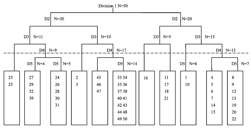
Fig. 1 Dendrogram of the TWINSPAN classification of 50 sample plots in tree layer. D indicates the level of division; N indicates the number of plots.
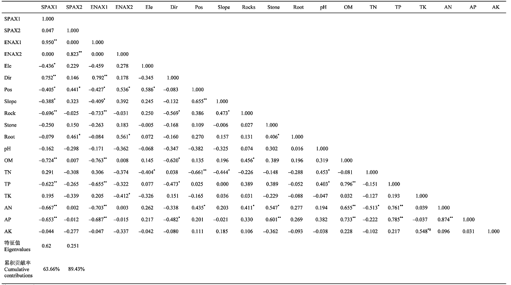 |
Table 1 The correlation coefficients of the first and second detrended canonical correspondence analysis ordination axes for forest communities and environmental factors
| |
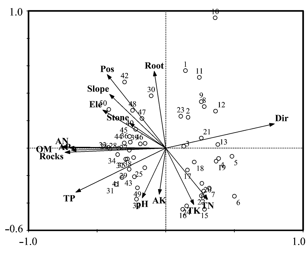
Fig. 2 The plots scores of DCCA ordination. The number from 1 to 50 in the map represents the code of the plots.
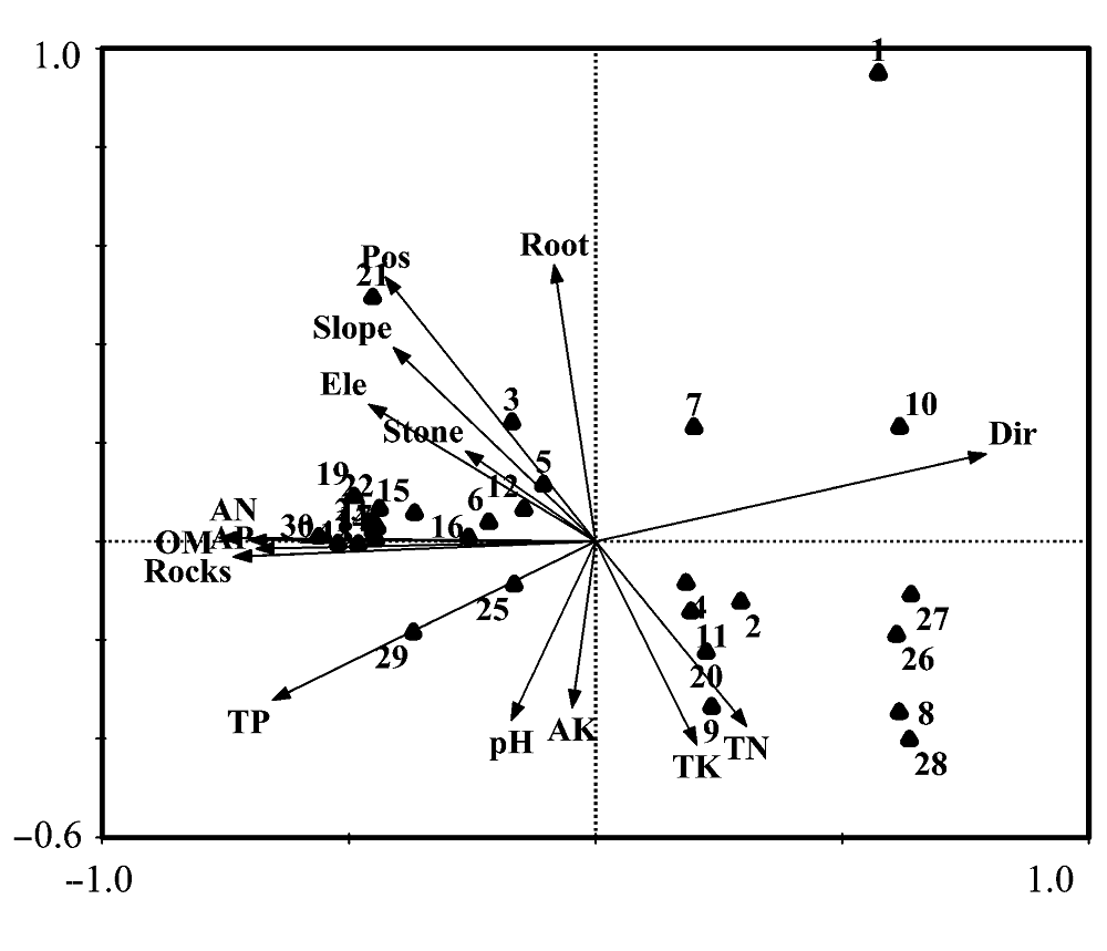
Fig. 3 The main species scores of DCCA ordination. The number from 1 to 30 represents the main species in the Mulun forest. 1, Rhus chinensis; 2, Callicarpa longifolia var. floccosa; 3, Cmnamomum saxitilis; 4, Radermachera sinica; 5, Celtis sinensis; 6, Mallotus philippensis; 7, Sapium rotundifolium; 8, Alangium chinense; 9, Mallotus repandus; 10, Liquidambar formosana; 11, Picrasma quassioides; 12, Alchornea trewioides; 13, Diospyros oleifera; 14 Murraya kwangsiensis; 15, Cryptocarya chinensis; 16, Clausena excavata; 17, Pteroceltis tatarinowii; 18, Sinosideroxylon pedurwulatum; 19, Rapanea kwangsiensis; 20, Mallotus barbatus var. croizatianus; 21, Mallotus japonicus var. floccosus; 22, Debregeasia longifolia; 23, Sterculia euosma; 24, Ligustrum japonicum; 25, Handeliodendron bodinieri; 26, Maesa japonica; 27, Derris trifoliata; 28, Cunninghamia lanceolata; 29, Tetrapanax papyrifer; 30, Koelreuteria minor.
| 群落格局的总体变异 Total variation of species abundance matrix | 2.393 |
| 群落格局的土壤环境解释部分 Sum of canonical eigenvalues for environmently constrained analysis | 0.937 |
| 群落格局的空间解释部分 Sum of canonical eigenvalues for spatially constrained analysis | 0.750 |
| 群落格局的单纯土壤环境解释部分 Sum of canonical eigenvalues for environmentally constrained analysis after removal effects of spatial factors | 0.503 |
| 群落格局的单纯空间解释部分 Sum of canonical eigenvalues for spatially constrained analysis after removal effects of environmental factors | 0.315 |
| 土壤环境因子对群落格局的解释能力 Species abundance variation explained by environmental variables (%) | 39.16 |
| 空间因子对群落格局的解释能力 Species abundance variation explained by spatial variables (%) | 31.34 |
| 单纯土壤环境因子对群落格局的解释能力 Species abundance variation explained by pure soil environmental factors (%) | 21.02 |
| 单纯空间因子对群落格局的解释能力 Species abundance variation explained by pure spatial factors (%) | 13.16 |
| 土壤环境因子、空间因子对群落格局的交互解释能力 Species abundance variation explained by crossed spatial-environmental factors (%) | 18.15 |
| 未能解释的部分 Unexplained species abundance variation (%) | 47.66 |
Table 2 Results of detrended canonical correspondence analysis and partitioning of the variation of species matrix
| 群落格局的总体变异 Total variation of species abundance matrix | 2.393 |
| 群落格局的土壤环境解释部分 Sum of canonical eigenvalues for environmently constrained analysis | 0.937 |
| 群落格局的空间解释部分 Sum of canonical eigenvalues for spatially constrained analysis | 0.750 |
| 群落格局的单纯土壤环境解释部分 Sum of canonical eigenvalues for environmentally constrained analysis after removal effects of spatial factors | 0.503 |
| 群落格局的单纯空间解释部分 Sum of canonical eigenvalues for spatially constrained analysis after removal effects of environmental factors | 0.315 |
| 土壤环境因子对群落格局的解释能力 Species abundance variation explained by environmental variables (%) | 39.16 |
| 空间因子对群落格局的解释能力 Species abundance variation explained by spatial variables (%) | 31.34 |
| 单纯土壤环境因子对群落格局的解释能力 Species abundance variation explained by pure soil environmental factors (%) | 21.02 |
| 单纯空间因子对群落格局的解释能力 Species abundance variation explained by pure spatial factors (%) | 13.16 |
| 土壤环境因子、空间因子对群落格局的交互解释能力 Species abundance variation explained by crossed spatial-environmental factors (%) | 18.15 |
| 未能解释的部分 Unexplained species abundance variation (%) | 47.66 |
| [1] | Academic Divisions of Chinese Academy of Sciences (中国科学院学部) (2003). Some propositions on advancing the comprehensive control of karst mountain areas in southeast China. Advance in Earth Science (地球科学进展), 18, 489-492. (in Chinese) |
| [2] | Bao SD (鲍士旦) (2000). Soil and Agricultural Chemistry Analysis (土壤农化分析). China Agriculture Press, Beijing. (in Chinese) |
| [3] | Borcard D, Legendre P, Drapeau P (1992). Partialling out the spatial component of ecological variation. Ecology, 73, 1045-1055. |
| [4] | Braak CJF Ter (1986). Canonical Correspondence analysis: a new eigenvector method for multivariate direct gradient analysis. Ecology, 67, 1167-1179. |
| [5] | Braak CJF Ter (1994). Canonical community ordination. Part I: basic theory and linear methods. Ecoscience, 1, 127-140. |
| [6] | Burke A (2001). Classification and ordination of plant communities of the Naukluft Mountains, Namibia. Journal of Vegetable Science, 12, 53-60. |
| [7] | Chave J (2004). Neutral theory and community ecology. Ecology Letters, 7, 241-253. |
| [8] | Denslow JS (1987). Tropical rainforest gaps and tree species diversity. Annual Review of Ecology and Systematics, 18, 431-451. |
| [9] | Hill MO (1979). TWINSPAN―a FORTRAN Program for Arranging Multivariate Data in an Ordered Two-way Table by Classification of the Individuals and Attributes. Section of Ecology and Systematics, Cornell University, Ithaca, New York. |
| [10] | Hubbell SP (2001). The Unified Neutral Theory of Biodiversity and Biogeography. Princeton University Press, Princeton. |
| [11] | Jiao JY (焦菊英), Ma XH (马祥华), Bai WJ (白文娟), Jiao F (焦峰), Wen ZM (温仲明) (2005). Correspondence analysis of vegetation communities and soil environmental factors on abandoned cropland on hilly-gullied loess plateau. Acta Pedologica Sinica (土壤学报), 42, 744-752. (in Chinese with English abstract) |
| [12] | Lan AJ (兰安军), Zhang BP (张百平), Xiong KN (熊康宁), An YL (安裕伦) (2003). Spatial pattern of the fragile karst environment in southwest Guizhou Province. Geographical Research (地理研究), 22, 733-741. (in Chinese with English abstract) |
| [13] | Leibold MA, Mcpeek MA (2006). Coexistence of the niche and neutral perspectives in community ecology. Ecology, 6, 1399-1410. |
| [14] | Liu YL (刘映良), Xue JH (薛建辉) (2005). Quantitative properties of degraded karst forest communities in Maolan Mountain area of Guizhou. Journal of Nanjing Forestry University (Natural Sciences Edition) (南京林业大学学报(自然科学版)), 29, 23-27. (in Chinese with English abstract) |
| [15] | Long J (龙健), Deng QQ (邓启琼), Jiang XR (江新荣), Li YB (李阳兵), Yao B (姚斌) (2005). Effects of landuse types on restoration of soil quality on karst rocky desertification region in Guizhou Province. Acta Ecologica Sinica (生态学报), 25, 3188-3195. (in Chinese with English abstract) |
| [16] | Nee S (2005). The neutral theory of biodiversity: Do the numbers add up? Functional Ecology, 191, 173-176. |
| [17] | Peng WX (彭晚霞), Wang KL (王克林), Song TQ (宋同清), Zeng FP (曾馥平), Wang JR (王久荣) (2008). Controlling and restoration models of complex degradation vulnerable karst ecosystem. Acta Ecologica Sinica (生态学报), 28, 811-820. (in Chinese with English abstract) |
| [18] | Pinder JE III, Kroh GC, White JD, Basham MAM (1997). The relationships between vegetation types and topography in Lassen Vocalnic National Park. Plant Ecology, 131, 17-29. |
| [19] | Qiu Y (邱扬), Zhang JT (张金屯) (2000). The ordination axes clustering based on detrended canonical correspondence analysis ordination and its application of the ecological gradients of plant communities. Acta Ecologica Sinica (生态学报), 20, 199-206. (in Chinese with English abstract) |
| [20] | Shea K (2004). Moving from pattern to process: coexistence mechanisms under intermediate disturbance regimes. Ecology Letters, 6, 491-508. |
| [21] | Shen ZH (沈泽昊), Zhang XS (张新时) (2000). The spatial pattern and topographic interpretation of the forest vegetation at Dalaoling Mountain in the Three Gorges Region. Acta Botanica Sinica (植物学报), 42, 1089-1095. (in Chinese with English abstract) |
| [22] | Shen ZH (沈泽昊), Zhang XS (张新时), Jin YX (金义兴) (2000). Gradient analysis of the influence of mountain topography on vegetation pattern. Acta Phytoecologica Sinica (植物生态学报), 24, 430-435. (in Chinese with English abstract) |
| [23] | Silver J (2004). Plant coexistence and the niche. Trends in Ecology and Evolution, 11, 605-611. |
| [24] | Song TQ (宋同清), Peng WX (彭晚霞), Zeng FP (曾馥平), Wang KL (王克林), Ouyang ZW (欧阳资文) (2008). Vegetation succession rule and regeneration strategies in disturbed karst area, northwest Guangxi. Journal of Mountain Science (山地学报), 26, 597-604. (in Chinese with English abstract) |
| [25] | Tang QY (唐启义), Feng MG (冯明光) (2002). DPS Data Processing System for Practical Statistics (实用统计分析及其DPS数据处理系统). Science Press, Beijing. (in Chinese) |
| [26] | Woodward FI, Mckoo IF (1991). Vegetation and climate. Environment International, 17, 535-546. |
| [27] | Wu HY (吴海勇), Peng WX (彭晚霞), Song TQ (宋同清), Zeng FP (曾馥平), Li XH (黎星辉), Song XJ (宋希娟), Ouyang ZW (欧阳资文) (2008). Changes of soil nutrients in process of natural vegetation restoration in karst disturbed area in northwest Guangxi. Journal of Soil and Water Conservation (水土保持学报), 22, 143-147. (in Chinese with English abstract) |
| [28] | Xin XP (辛晓平), Gao Q (高琼), Li ZQ (李镇清), Yang ZY (杨正宇) (1999). Partitioning the spatial and environmental variation of plant community structure of alkaline grassland on Songnen Plain. Acta Botanica Sinica (植物学报), 41, 775-781. (in Chinese with English abstract) |
| [29] | Yang MD (杨明德), Liang H (梁虹) (2002). The processes of evolution dynamic of cone karst and the exploitation of the water resource. Carsologica Sinica (中国岩溶), 19, 44-51. (in Chinese with English abstract) |
| [30] | Yu LF (喻理飞), Zhu SQ (朱守谦), Ye JZ (叶镜中), Wei LM (魏鲁明), Chen ZR (陈正仁) (2002). Dynamics of a degraded karst forest in the process of natural restoration. Scientia Silvae Sinicae (林业科学), 38, 1-7. (in Chinese with English abstract) |
| [31] | Yue YM (岳跃民), Wang KL (王克林), Zhang W (张伟), Chen HS (陈洪松), Wang M (王敏) (2008). Relationships between soil and environment in peak-cluster depression areas of karst region based on canonical correspondence analysis. Environmental Science (环境科学), 29, 1400-1405. (in Chinese with English abstract) |
| [32] | Zeng FP (曾馥平), Peng WX (彭晚霞), Song TQ (宋同清), Wang KL (王克林), Wu HY (吴海勇), Song XJ (宋希娟), Zeng ZX (曾昭霞) (2007). Changes in vegetation after 22 years’ natural restoration in the karst disturbed area in Northwest Guangxi. Acta Ecologica Sinica (生态学报), 27, 5110-5119. (in Chinese with English abstract) |
| [33] | Zhang WH (张文辉), Lu T (卢涛), Ma KM (马克明), Zhou JY (周建云), Liu SL (刘世梁) (2004). Analysis on the environmental and spatial factors for plant community distribution in the arid valley in the upper reach of Minjiang River. Acta Ecologica Sinica (生态学报), 24, 552-559. (in Chinese with English abstract) |
| [34] | Zhang F (张峰), Zhang JT (张金屯), Zhang F (张峰) (2003). Pattern of forest vegetation and its environmental interpretation in Zhuweigou, Lishan Mountain Nature Reserve. Acta Ecologica Sinica (生态学报), 23, 421-427. (in Chinese with English abstract) |
| [35] | Zhang JT (张金屯) (1995). Methods of Quantitative Vegetation Ecology (植被数量生态学方法). China Science and Technology Press, Beijing. (in Chinese) |
| [36] | Zheng YW (郑颖吾) (1999). Introduction to Mulun Karst Forest Region (木论喀斯特林区概论). Science Press, Beijing. (in Chinese) |
| [1] | ZHAO Chang-Xing, ZHAO Wei-Jun, ZHANG Xing-Lin, LIU Si-Min, MOU Wen-Bo, LIU Jin-Rong. Analyses of intraspecific competition and facilitation of Picea crassifolia in Pailugou Watershed of Qilian Mountains, China [J]. Chin J Plant Ecol, 2022, 46(9): 1027-1037. |
| [2] | CHEN Shi-Ping, YOU Cui-Hai, HU Zhong-Min, CHEN Zhi, ZHANG Lei-Ming, WANG Qiu-Feng. Eddy covariance technique and its applications in flux observations of terrestrial ecosystems [J]. Chin J Plant Ecol, 2020, 44(4): 291-304. |
| [3] | TANG Li-Li, YANG Tong, LIU Hong-Yan, KANG Mu-Yi, WANG Ren-Qing, ZHANG Feng, GAO Xian-Ming, YUE Ming, ZHANG Mei, ZHENG Pu-Fan, SHI Fu-Chen. Distribution and species diversity patterns of Vitex negundo var. heterophylla shrublands in North China [J]. Chin J Plant Ecol, 2019, 43(9): 825-833. |
| [4] | QIN Hao, ZHANG Yin-Bo, DONG Gang, ZHANG Feng. Altitudinal patterns of taxonomic, phylogenetic and functional diversity of forest communities in Mount Guandi, Shanxi, China [J]. Chin J Plant Ecol, 2019, 43(9): 762-773. |
| [5] | Bo-Liang WEI, Zhi-Liang YUAN, Shuai NIU, Xia LIU, Hong-Ru JIA, Yong-Zhong YE. Effects of tree mortality on the spatial patterns and interspecific associations of plant species in a Quercus aliena var. acuteserrata forest in Baotianman, Henan, China [J]. Chin J Plan Ecolo, 2017, 41(4): 430-438. |
| [6] | Jie-Lin GE, Gao-Ming XIONG, Jia-Xiang LI, Wen-Ting XU, Chang-Ming ZHAO, Zhi-Jun LU, Yue-Lin LI, Zong-Qiang XIE. Litter standing crop of shrubland ecosystems in southern China [J]. Chin J Plant Ecol, 2017, 41(1): 5-13. |
| [7] | ZHU Xu-Chao, YUAN Guo-Fu, SHAO Ming-An, YI Xiao-Bo, DU Tao. Spatial pattern of riparian vegetation in desert of the lower Tarim River basin [J]. Chin J Plan Ecolo, 2015, 39(11): 1053-1061. |
| [8] | LIANG Shuang, XU Han, LIN Jia-Yi, LI Yi-De, LIN Ming-Xian. Spatial distribution pattern of the dominant species Gironniera subaequalis in tropical montane rainforest of Jianfengling, Hainan Island, China [J]. Chin J Plant Ecol, 2014, 38(12): 1273-1282. |
| [9] | ZHANG Wei-Ping,PAN Sha,JIA Xin,CHU Cheng-Jin,XIAO Sa,LIN Yue,BAI Yan-Yuan,WANG Gen-Xuan. Effects of positive plant interactions on population dynamics and community structures: a review based on individual-based simulation models [J]. Chin J Plant Ecol, 2013, 37(6): 571-582. |
| [10] | XU Li,YU Shu-Xia,HE Nian-Peng,WEN Xue-Fa,SHI Pei-Li,ZHANG Yang-Jian,DAI Jing-Zhong,WANG Ruo-Meng. Soil C mineralization and temperature sensitivity in alpine grasslands of the Qinghai-Xizang Plateau [J]. Chin J Plant Ecol, 2013, 37(11): 988-997. |
| [11] | HUANG Yun-Feng,DING Yi,ZANG Run-Guo,LI Xiao-Cheng,ZOU Zheng-Chong,HAN Wen-Tao. Spatial pattern of trees in tropical lowland rain forest in Bawangling of Hainan Island, China [J]. Chin J Plant Ecol, 2012, 36(4): 269-280. |
| [12] | YU Hong, YANG Xiao-Hui, CI Long-Jun. VARIATIONS OF SPATIAL PATTERN IN FIRE-MEDIATED MONGOLIAN PINE FOREST, HULUN BUIR SAND REGION, INNER MONGOLIA, CHINA [J]. Chin J Plant Ecol, 2009, 33(1): 71-80. |
| [13] | LIN Yue, REN Jian-Yi, YUE Ming. POPULATION STRUCTURE AND SPATIAL ANALYSIS OF BETULA ALBO- SINENSIS AT TAIBAI MOUNTAIN, NORTHWESTERN CHINA [J]. Chin J Plant Ecol, 2008, 32(6): 1335-1345. |
| [14] | LI Zeng-Jia, MA You-Xin, LI Hong-Mei, PENG Ming-Chun, LIU Wun-Jun. RELATION OF LAND USE AND COVER CHANGE TO TOPOGRAPHY IN XISHUANGBANNA, SOUTHWEST CHINA [J]. Chin J Plant Ecol, 2008, 32(5): 1091-1103. |
| [15] | YE Wan-Hui, CAO Hong-Lin, HUANG Zhong-Liang, LIAN Ju-Yu, WANG Zhi-Gao, LI Lin, WEI Shi-Guang, WANG Zhang-Ming. COMMUNITY STRUCTURE OF A 20 HM2 LOWER SUBTROPICAL EVERGREEN BROADLEAVED FOREST PLOT IN DINGHUSHAN, CHINA [J]. Chin J Plant Ecol, 2008, 32(2): 274-286. |
| Viewed | ||||||
|
Full text |
|
|||||
|
Abstract |
|
|||||
Copyright © 2022 Chinese Journal of Plant Ecology
Tel: 010-62836134, 62836138, E-mail: apes@ibcas.ac.cn, cjpe@ibcas.ac.cn