植物生态学报 ›› 2007, Vol. 31 ›› Issue (5): 842-849.DOI: 10.17521/cjpe.2007.0106

• 论文 • 上一篇    下一篇

基于数字相机、ASTER和MODIS影像综合测量植被盖度

张云霞1,2, 李晓兵1,*(), 张云飞3   

  1. 1 北京师范大学环境演变与自然灾害教育部重点实验室,北京师范大学资源学院,北京 100875
    2 民政部国家减灾中心,北京 100053
    3 上海市科技馆,上海 200127
  • 收稿日期:2006-02-01 接受日期:2006-09-13 出版日期:2007-02-01 发布日期:2007-09-30
  • 通讯作者: 李晓兵
  • 作者简介:* E-mail: xbli@ires.cn
  • 基金资助:
    国家自然科学基金项目(30370265);教育部新世纪优秀人才资助计划项目

DETERMINING VEGETATION COVER BASED ON FIELD DATA AND MULTI-SCALE REMOTELY SENSED DATA

ZHANG Yun-Xia1,2, LI Xiao-Bing1,*(), ZHANG Yun-Fei3   

  1. 1College of Resources Science and Technology, Beijing Normal University, Key Laboratory of Environmental Change and Natural Disaster of Ministry of Education, Beijing Normal University, Beijing 100875, China
    2National Disaster Reduction Center of China, Beijing 100053, China
    3Shanghai Science & Technology Museum, Shanghai 200127, China
  • Received:2006-02-01 Accepted:2006-09-13 Online:2007-02-01 Published:2007-09-30
  • Contact: LI Xiao-Bing

摘要:

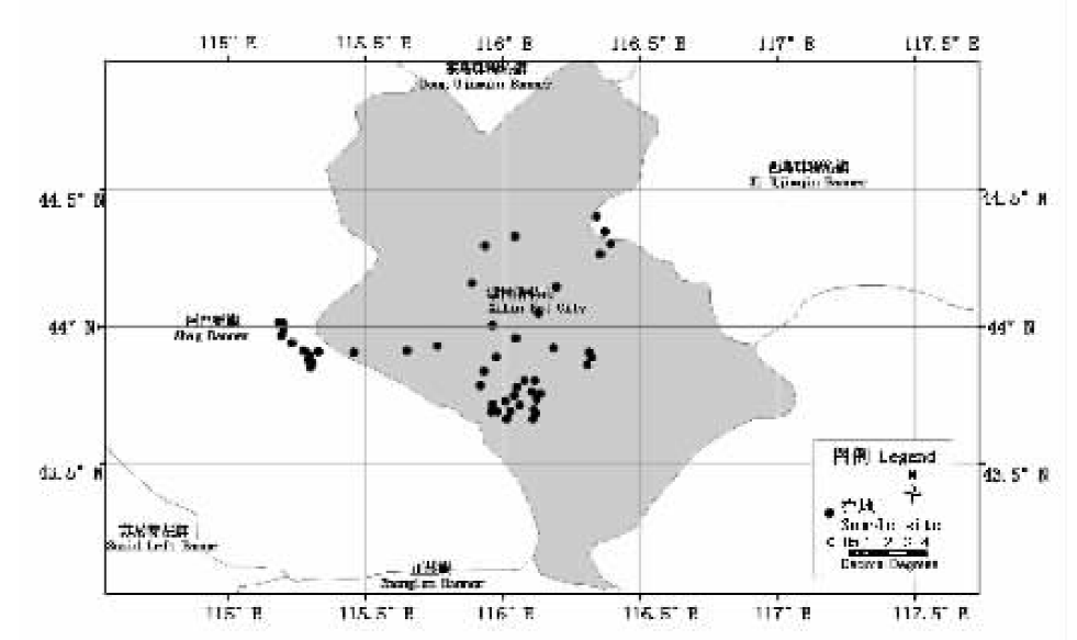
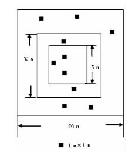
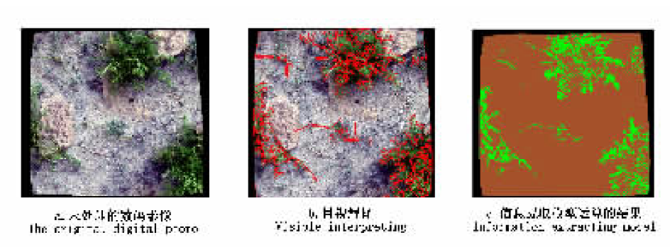
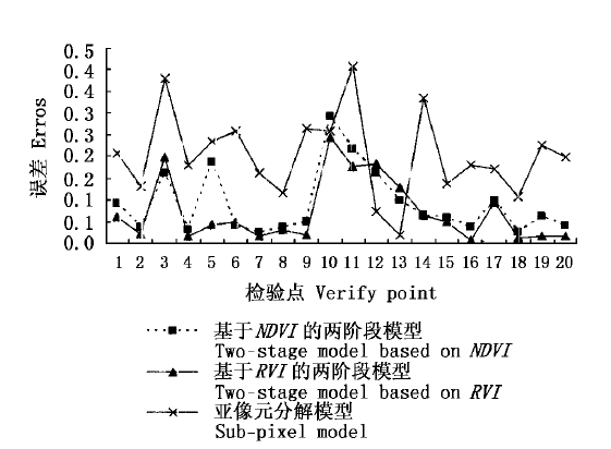
选择我国北方温带典型草原作为研究对象,基于Bottom-up方法,采用地表实测和多尺度遥感综合测量的方法,建立基于地表实测与多尺度遥感数据综合测量的两阶段植被盖度经验模型。此外,还将该模型与常用的亚像元分解模型相比较,结果表明:1)两阶段经验模型可以较好地实现将地面数据扩展到中尺度空间范围,从而完成数据空间尺度的转换,提高大区域草地植被盖度的测量精度;2)MODIS遥感影像数据,结合地面数据和ASTER遥感影像数据可以较好地在区域范围内对北方典型草原的植被盖度进行估测;3)目前常用的亚像元分解模型,应用于中空间分辨率的MODIS影像,估测北方温度典型草原植被盖度的精度不够理想。

关键词: 草地植被盖度, 地表实测数据, 多尺度遥感数据, 两阶段植被盖度经验模型

Abstract:

Aims There are problems with estimating vegetation cover using remotely sensed data. Many models have been developed by regression of field data and remotely sensed data, but this simple scale transformation often results in large errors. Our objective was to combine field data and multi-scale remotely sensed data to estimate vegetation cover for a typical temperate steppe of North China.

Methods Within our research area, we selected 49 sample fields from areas with high, medium and low vegetation cover and sampled each using 1 m plots nested within larger plots. We vertically photographed each 1 m sample plot with a digital camera positioned at 2 m height. We estimated vegetation cover in each image. Using these data and data obtained through ASTER and MODIS images, we developed a two-stage experiential model of vegetation cover based on the bottom-up method.

Important findings We accurately estimated vegetation cover of typical temperate steppe of North China at a regional scale based on our two-stage model using field data and ASTER and MODIS images. Using a series of MODIS images, it would be possible to estimate vegetation cover of typical steppe across China.

Key words: vegetation cover, grassland, field data, multi-scale remotely sensed data, two-stage experiential model