
植物生态学报 ›› 2007, Vol. 31 ›› Issue (5): 850-856.DOI: 10.17521/cjpe.2007.0107 cstr: 32100.14.cjpe.2007.0107
王辉1( ), 昝国盛2, 毕晓丽3, 周睿4, 熊友才1, 洪军5, 葛剑平1,*()
收稿日期:2006-06-23
接受日期:2006-09-08
出版日期:2007-06-23
发布日期:2007-09-30
作者简介:* E-mail: gejp@bnu.edu.cn基金资助:
WANG Hui1(), ZAN Guo-Sheng2, BI Xiao-Li3, ZHOU Rui4, XIONG You-Cai1, HONG Jun5, GE Jian-Ping1,*()
Received:2006-06-23
Accepted:2006-09-08
Online:2007-06-23
Published:2007-09-30
摘要:
以中分辨率成像光谱仪数据(Moderate resolution imaging spectroradiometer, MODIS)为基础计算泾河流域归一化差异植被指数(Normalized difference vegetation index, NDVI)在2001~2004年的时间序列值,分别采用相关系数r值和成对t检验的t值定量描述年内NDVI曲线在年际间的协同性和差异性。以农田、森林、灌丛和草地4种土地利用类型NDVI曲线在年际间变化显著的面积百分比为参数,在2001~2004年间分为1、2和3年间隔共6个时间组,比较分析4种土地利用类型的NDVI曲线在6个时间组内的协同性和差异性,进而探讨泾河流域植被年际变化及其与土地利用之间的关系。结果表明:4种土地利用类型NDVI波动对外界环境的响应在不同的时间间隔里表现一致,在2001~2003年和2001~2004年间变化比较明显;在各个时间组内比较发现有较大面积的农田和草地NDVI协同性较差,尤其在2001~2002年间,这可能与退耕还林还草政策的实施有关;4年来泾河流域内4种土地利用类型的NDVI值有增加趋势,植被状况趋于良好;NDVI年际间差异最明显的是草地,其次是农田和灌丛,森林的NDVI比较稳定。
王辉, 昝国盛, 毕晓丽, 周睿, 熊友才, 洪军, 葛剑平. 基于MODIS的泾河流域植被动态年际变化. 植物生态学报, 2007, 31(5): 850-856. DOI: 10.17521/cjpe.2007.0107
WANG Hui, ZAN Guo-Sheng, BI Xiao-Li, ZHOU Rui, XIONG You-Cai, HONG Jun, GE Jian-Ping. MODIS-DETERMINED INTER-ANNUAL VEGETATION DYNAMICS IN JINGHE WATERSHED, CHINA. Chinese Journal of Plant Ecology, 2007, 31(5): 850-856. DOI: 10.17521/cjpe.2007.0107
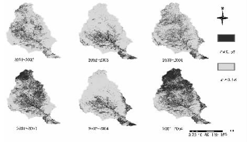
图1 6个时间段的NDVI曲线相关性计算结果
Fig.1 The NDVI calculated results of the correlation at six temporal intervals
| 土地利用类型 Land use types | 时间段 Temporal interval (Year) | ||||||||||
|---|---|---|---|---|---|---|---|---|---|---|---|
| 2001~2002 | 2002~2003 | 2003~2004 | 2001~2003 | 2002~2004 | 2001~2004 | ||||||
| 农田 Crop | 21.82 | 21.17 | 3.27 | 42.82 | 18.42 | 48.60 | |||||
| 森林 Forest | 3.54 | 4.36 | 0.43 | 13.93 | 25.63 | 40.71 | |||||
| 灌丛 Shrub | 7.26 | 10.83 | 1.17 | 22.59 | 17.52 | 34.35 | |||||
| 草地 Grass | 16.01 | 8.81 | 1.14 | 37.58 | 9.16 | 51.10 | |||||
表1 4种土地利用类型协同性较差的面积百分比
Table 1 The area percentage of the consistence of a sort among four land use types (%)
| 土地利用类型 Land use types | 时间段 Temporal interval (Year) | ||||||||||
|---|---|---|---|---|---|---|---|---|---|---|---|
| 2001~2002 | 2002~2003 | 2003~2004 | 2001~2003 | 2002~2004 | 2001~2004 | ||||||
| 农田 Crop | 21.82 | 21.17 | 3.27 | 42.82 | 18.42 | 48.60 | |||||
| 森林 Forest | 3.54 | 4.36 | 0.43 | 13.93 | 25.63 | 40.71 | |||||
| 灌丛 Shrub | 7.26 | 10.83 | 1.17 | 22.59 | 17.52 | 34.35 | |||||
| 草地 Grass | 16.01 | 8.81 | 1.14 | 37.58 | 9.16 | 51.10 | |||||
| 土地利用类型 Land use types | 年份 Year | |||
|---|---|---|---|---|
| 2001 | 2002 | 2003 | 2004 | |
| 农田 Crop | 0.30 | 0.33 | 0.33 | 0.34 |
| 森林 Forest | 0.43 | 0.46 | 0.47 | 0.48 |
| 灌丛 Shrub | 0.40 | 0.43 | 0.49 | 0.45 |
| 草地 Grass | 0.29 | 0.33 | 0.33 | 0.33 |
表2 4种土地利用类型的NDVI平均值
Table 2 The mean value of NDVI among four land use types
| 土地利用类型 Land use types | 年份 Year | |||
|---|---|---|---|---|
| 2001 | 2002 | 2003 | 2004 | |
| 农田 Crop | 0.30 | 0.33 | 0.33 | 0.34 |
| 森林 Forest | 0.43 | 0.46 | 0.47 | 0.48 |
| 灌丛 Shrub | 0.40 | 0.43 | 0.49 | 0.45 |
| 草地 Grass | 0.29 | 0.33 | 0.33 | 0.33 |
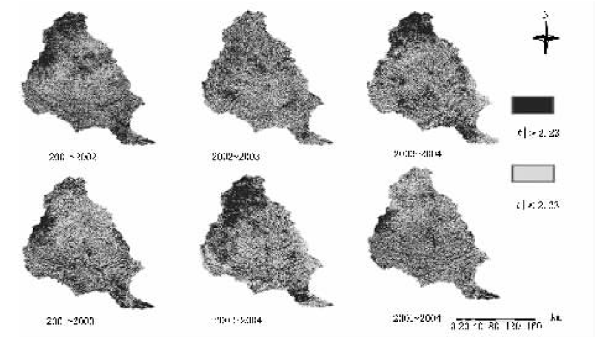
图2 6个时间段NDVI比较的t检验结果
Fig.2 The NDVI calculated results of t-test at six temporal intervals
| 土地利用类型 Land use types | 时间段 Temporal interval (Year) | |||||
|---|---|---|---|---|---|---|
| 2001~2002 | 2002~2003 | 2003~2004 | 2001~2003 | 2002~2004 | 2001~2004 | |
| 农田 Crop | 25.86 | 1.86 | 10.77 | 21.70 | 6.71 | 21.33 |
| 森林 Forest | 21.37 | 0.79 | 5.47 | 10.80 | 2.50 | 11.89 |
| 灌丛 Shrub | 23.10 | 1.20 | 7.35 | 13.95 | 4.47 | 15.90 |
| 草地 Grass | 35.73 | 2.00 | 12.25 | 28.60 | 6.44 | 24.35 |
表3 4种土地利用类型平均值差异显著的面积百分比
Table 3 The area percent of significant difference in the mean value of NDVI among four land use types (%)
| 土地利用类型 Land use types | 时间段 Temporal interval (Year) | |||||
|---|---|---|---|---|---|---|
| 2001~2002 | 2002~2003 | 2003~2004 | 2001~2003 | 2002~2004 | 2001~2004 | |
| 农田 Crop | 25.86 | 1.86 | 10.77 | 21.70 | 6.71 | 21.33 |
| 森林 Forest | 21.37 | 0.79 | 5.47 | 10.80 | 2.50 | 11.89 |
| 灌丛 Shrub | 23.10 | 1.20 | 7.35 | 13.95 | 4.47 | 15.90 |
| 草地 Grass | 35.73 | 2.00 | 12.25 | 28.60 | 6.44 | 24.35 |
| 土地利用类型 Land use types | 时间段 Temporal interval (Year) | |||||
|---|---|---|---|---|---|---|
| 2001~2002 | 2002~2003 | 2003~2004 | 2001~2003 | 2002~2004 | 2001~2004 | |
| 农田 Crop | 2.75 | 0.06 | 0.13 | 6.66 | 1.04 | 6.72 |
| 森林 Forest | 0.70 | 0.02 | 0.01 | 2.06 | 0.20 | 3.19 |
| 灌丛 Shrub | 1.08 | 0.00 | 0.24 | 3.09 | 0.70 | 4.89 |
| 草地 Grass | 3.57 | 0.00 | 0.04 | 9.06 | 0.34 | 9.07 |
表4 4种土地利用类型NDVI年际变化显著的面积百分比
Table 4 The percent area of significant difference in inter-annual NDVI among four land use types (%)
| 土地利用类型 Land use types | 时间段 Temporal interval (Year) | |||||
|---|---|---|---|---|---|---|
| 2001~2002 | 2002~2003 | 2003~2004 | 2001~2003 | 2002~2004 | 2001~2004 | |
| 农田 Crop | 2.75 | 0.06 | 0.13 | 6.66 | 1.04 | 6.72 |
| 森林 Forest | 0.70 | 0.02 | 0.01 | 2.06 | 0.20 | 3.19 |
| 灌丛 Shrub | 1.08 | 0.00 | 0.24 | 3.09 | 0.70 | 4.89 |
| 草地 Grass | 3.57 | 0.00 | 0.04 | 9.06 | 0.34 | 9.07 |
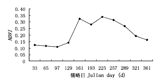
图3 抽样的农田NDVI曲线
Fig.3 The sampled result of normalized difference vegetation index (NDVI) time serial in cropl
| [1] | Chen J, Jonsson P, Tamura M (2001). A simple method for reconstructing a high-quality NDVI time-series data set based on the Savitzky-Golay filter. Remote Sensing Environment, 91,332-344. |
| [2] | Chen YH (陈云浩), Li XB (李晓兵), Shi PJ (史培军) (2001). Variation in NDVI driven by climate factors across China 1983-1992. Acta Phytoecologica Sinica (植物生态学报), 25,716-720. (in Chinese with English abstract) |
| [3] | Cheng JM (程积民), Wan HE (万惠娥) (2002). The Vegetation Restoration and the Soil and Water Conservation in the Loess Plateau in China (中国黄土高原植被恢复与水土保持). China Forestry Publishing House, Beijing,163-201. (in Chinese) |
| [4] | Feng Q (冯强), Tian GL (田国良), Wang AS (王昂生), Liu QH (柳钦火), McVicar TR, Jupp DLB (2004). Experimental study on drought monitoring by remote sensing in China by using vegetation condition indexes. Data analysis and processing. Arid Land Geography (干旱区地理), 27,132-136. (in Chinese with English abstract) |
| [5] | Guo ZH (郭志华), Peng SL (彭少麟), Wang BS (王伯荪) (2001). Estimation of solar energy use efficiency and spatiotemporal pattern in Guangdong based on multi-temporal NOAA-AVHRR NDVI and GIS methods. Acta Botanica Sinica (植物学报), 43,857-862. (in Chinese with English abstract) |
| [6] | Jiang JJ, Chen SZ, Cao SX, Wu HG, Zhang L, Zhang HL (2005). Leaf area index retrieval based on canopy reflectance and vegetation index in eastern China. Journal of Geographical Sciences, 15,247-254. |
| [7] | Li BG (李本纲), Tao S (陶澍) (2000). Correlation between AVHRR NDVI and climate factors. Acta Ecologica Sinica (生态学报), 20,898-902. (in Chinese with English abstract) |
| [8] | Li XB (李晓兵), Chen YH (陈云浩), Yu F (喻锋) (2004). Global and regional cover mapping from remote sensing data: status quo, strategies and trends. Advance in Earth Sciences (地球科学进展), 19,71-80. (in Chinese with English abstract) |
| [9] | Li XB (李晓兵), Shi PJ (史培军) (1999). Research on regulation of NDVI change of Chinese primary vegetation types based on NOAA/AVHRR data. Acta Botanica Sinica (植物学报), 41,314-324. (in Chinese with English abstract) |
| [10] | Li Y, Liao SD (2004). NPP distribution related to the terrains along the north-south transect of eastern China. Chinese Science Bulletin, 49,617-624. |
| [11] | Li Z (李震), Yan FL (阎福礼), Fan XT (范湘涛) (2005). The variability of NDVI over northwest China and its relation to temperature and precipitation. Journal of Remote Sensing (遥感学报), 9,308-313. (in Chinese with English abstract) |
| [12] | Los SO, Justice CO, Tucker CJ (1994). A global 1 degree by 1 degree NDVI data set for climate studies derived from the GIMMS continental NDVI data. International Journal of Remote Sensing, 15,3493-3518. |
| [13] |
Lucht W, Prentice IC, Myneni RB, Sitch S, Friedlingstein P, Cramer W, Bousquet P, Buermann W, Smith B (2002). Climatic control of the high-latitude vegetation greening trend and Pinatubo effect. Science, 296,1687-1689.
DOI URL PMID |
| [14] | Lyon GJ, Yuan D, Lunetta RS, Elvidge CD (1998). A change detection experiment using vegetation indices. Photogramm Engineer & Remote Sensing, 64,143-150. |
| [15] | Mass JF (1999). Monitoring land-cover changes: a comparison of change detection techniques. International Journal of Remote Sensing, 20,139-152. |
| [16] | Myneni RB, Keeling CD, Tucker CJ, Asrar G, Nemani RR (1997). Increased plant growth in the northern high latitudes from 1981 to 1991. Nature, 386,698-702. |
| [17] | Piao SL (朴世龙), Fang JY (方精云) (2002). Terrestrial net primary production and its spatio-temporal patterns in Qinghai-Xizang Plateau, China during 1982-1999. Journal of Natural Resources (自然资源学报), 17,374-379. (in Chinese with English abstract) |
| [18] | Tucker CJ, Fung IY, Keeling CD, Gammon RH (1986). Relationship between atmospheric CO2 variations and a satellite-derived vegetation index. Nature, 319,195-199. |
| [19] | Wang Q, Ni J, Tenhunen J (2005). Application of a geographically-weighted regression analysis to estimate net primary production of Chinese forest ecosystems. Global Ecology & Biogeography, 14,379-393. |
| [20] | Woodcock CE, Macomber SA, Pax-Lenney M, Cohen WB (2001). Monitoring large areas for forest change using Landsat: generalization across space, time and Landsat sensors. Remote Sensing of Environment, 78,194-203. |
| [21] | Wu BF (吴炳方), Zhang F (张峰), Liu CL (刘成林), Zhang L (张磊), Luo ZM (罗治敏) (2004). An integrated method for crop condition monitoring. Journal of Remote Sensing (遥感学报), 8,498-513. (in Chinese with English abstract) |
| [22] | Zhang J (张军), Ge JP (葛剑平), Guo QX (国庆喜) (2001). The relation between the change of NDVI of the main vegetational types and the climatic factors in the northeast of China. Acta Ecologica Sinica (生态学报), 21,522-527. (in Chinese with English abstract) |
| [1] | 张智洋, 赵颖慧, 甄贞. 基于LUCC的1986-2022年松花江流域陆地生态系统碳储量动态监测[J]. 植物生态学报, 2024, 48(10): 1274-1290. |
| [2] | 张宏锦, 王娓. 生态系统多功能性对全球变化的响应: 进展、问题与展望[J]. 植物生态学报, 2021, 45(10): 1112-1126. |
| [3] | 牛书丽, 陈卫楠. 全球变化与生态系统研究现状与展望[J]. 植物生态学报, 2020, 44(5): 449-460. |
| [4] | 白娥, 薛冰. 土地利用与土地覆盖变化对生态系统的影响[J]. 植物生态学报, 2020, 44(5): 543-552. |
| [5] | 王祥, 朱亚琼, 郑伟, 关正翾, 盛建东. 昭苏山地草甸4种典型土地利用方式下的土壤呼吸特征[J]. 植物生态学报, 2018, 42(3): 382-396. |
| [6] | 李静鹏, 郑志荣, 赵念席, 高玉葆. 刈割、围封、放牧三种利用方式下草原生态系统的多功能性与植物物种多样性之间的关系[J]. 植物生态学报, 2016, 40(8): 735-747. |
| [7] | 菊花, 申国珍, 马明哲, 葛结林, 徐文婷, 赵常明, 张秋良. 北亚热带地带性森林土壤温室气体通量对土地利用方式改变和降水减少的响应[J]. 植物生态学报, 2016, 40(10): 1049-1063. |
| [8] | 彭资, 谷成燕, 刘智勇, 林雯, 周平. 东江流域1989-2009年土地利用变化对生态承载力的影响[J]. 植物生态学报, 2014, 38(7): 675-686. |
| [9] | 徐丽,于书霞,何念鹏,温学发,石培礼,张扬建,代景忠,王若梦. 青藏高原高寒草地土壤碳矿化及其温度敏感性[J]. 植物生态学报, 2013, 37(11): 988-997. |
| [10] | 李铭, 朱利川, 张全发, 程晓莉. 不同土地利用类型对丹江口库区土壤氮矿化的影响[J]. 植物生态学报, 2012, 36(6): 530-538. |
| [11] | 孙晓鹏, 王天明, 寇晓军, 葛剑平. 黄土高原泾河流域长时间序列的归一化植被指数动态变化及其驱动因素分析[J]. 植物生态学报, 2012, 36(6): 511-521. |
| [12] | 代景忠, 卫智军, 何念鹏, 王若梦, 温学华, 张云海, 赵小宁, 于贵瑞. 封育对羊草草地土壤碳矿化激发效应和温度敏感性的影响[J]. 植物生态学报, 2012, 36(12): 1226-1236. |
| [13] | 唐丽霞, 张志强, 王新杰, 王盛萍, 查同刚. 晋西黄土高原丘陵沟壑区清水河流域径流对土地利用与气候变化的响应[J]. 植物生态学报, 2010, 34(7): 800-810. |
| [14] | 张璐, 黄建辉, 白永飞, 韩兴国. 氮素添加对内蒙古羊草草原净氮矿化的影响[J]. 植物生态学报, 2009, 33(3): 563-569. |
| [15] | 齐清, 王天明, 寇晓军, 葛剑平. 泾河流域植被覆盖时空演变及其与降水的关系[J]. 植物生态学报, 2009, 33(2): 246-253. |
| 阅读次数 | ||||||
|
全文 |
|
|||||
|
摘要 |
|
|||||
Copyright © 2026 版权所有 《植物生态学报》编辑部
地址: 北京香山南辛村20号, 邮编: 100093
Tel.: 010-62836134, 62836138; Fax: 010-82599431; E-mail: apes@ibcas.ac.cn, cjpe@ibcas.ac.cn
备案号: 京ICP备16067583号-19
![]()