
植物生态学报 ›› 2012, Vol. 36 ›› Issue (6): 511-521.DOI: 10.3724/SP.J.1258.2012.00511
孙晓鹏, 王天明*( ), 寇晓军, 葛剑平
收稿日期:2012-02-13
接受日期:2012-04-11
出版日期:2012-02-13
发布日期:2012-06-04
通讯作者:
王天明
作者简介:*(E-mail:wangtianming@bnu.edu.cn)
SUN Xiao-Peng, WANG Tian-Ming*(), KOU Xiao-Jun, GE Jian-Ping
Received:2012-02-13
Accepted:2012-04-11
Online:2012-02-13
Published:2012-06-04
Contact:
WANG Tian-Ming
摘要:
泾河流域土地开发历史悠久, 是黄土高原水土流失的典型区域。研究气候变化和人类活动影响下泾河流域的植被覆盖变化及其原因, 对黄土高原的植被恢复、水土保持和景观管理等都具有重要意义。该研究应用GIMMS归一化植被指数NDVI、土地覆盖分类数据和气候数据, 采用趋势分析和相关分析方法, 研究了泾河流域1982-2005年植被覆盖变化趋势及其驱动因素。研究表明: 泾河流域24年间79.64%的区域NDVI无显著变化趋势, NDVI趋势显著增加的区域占16.33%, 主要集中在流域中部和南部, NDVI趋势显著减小的区域占4.03%, 主要集中在流域北部。流域所有气象站点的降水量均无显著变化趋势, 气温均呈显著升高趋势。分析发现气候变化不能很好地解释NDVI趋势的空间分异, 人为因素更为重要。从土地利用分析结果来看, NDVI不同趋势下各土地利用类型比例无明显变化, 但NDVI显著增加区以耕地为主, 显著减小区以草地为主, 由此推断NDVI的显著增加趋势主要由耕地NDVI增加引起, 显著减小趋势可能与林地减少和草地退化有关。通过分析不同分区的土地利用数据和社会经济资料, 着重探讨了造成植被覆盖显著变化趋势的人为因素。
孙晓鹏, 王天明, 寇晓军, 葛剑平. 黄土高原泾河流域长时间序列的归一化植被指数动态变化及其驱动因素分析. 植物生态学报, 2012, 36(6): 511-521. DOI: 10.3724/SP.J.1258.2012.00511
SUN Xiao-Peng, WANG Tian-Ming, KOU Xiao-Jun, GE Jian-Ping. Normalized difference vegetation index dynamic change and its driving factor analysis with long time series in the Jinghe River watershed on the Loess Plateau of China. Chinese Journal of Plant Ecology, 2012, 36(6): 511-521. DOI: 10.3724/SP.J.1258.2012.00511
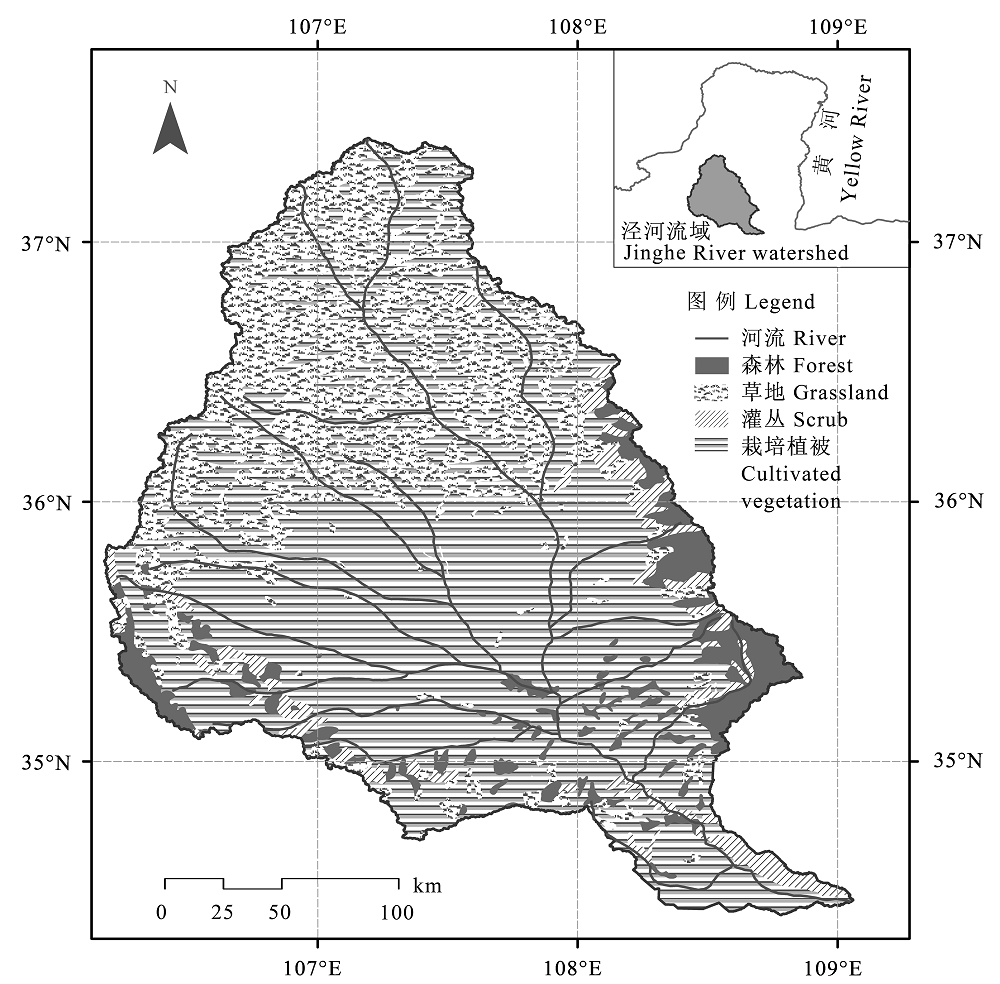
图1 泾河流域位置及主要植被分布(据中国科学院中国植被图编辑委员会, 2001)。
Fig. 1 The location and vegetation distribution of Jinghe River watershed (According to the Editorial Board of Vegetation Map of China, Chinese Academy of Sciences, 2001).
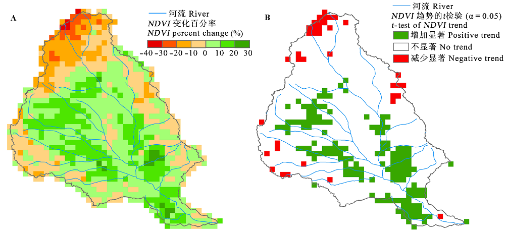
图2 泾河流域1982-2005年归一化植被指数(NDVI)趋势分析(A)及显著性检验(B)。
Fig. 2 Trend analysis (A) and significant test (B) of normalized difference vegetation index (NDVI) in Jinghe River watershed from 1982 to 2005.
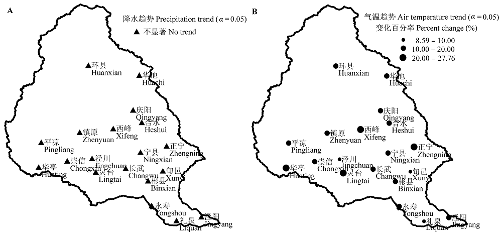
图3 泾河流域气象站点1982-2005年降水量(A)和气温(B)趋势。
Fig. 3 Precipitation (A) and air temperature (B) trends of meteorological stations in Jinghe River watershed from 1982 to 2005.
| 站点编号 Station code | 站点名称 Station name | NDVI趋势 NDVI trend | 降水趋势 P trend | 气温趋势 T trend | 相关系数 Correlation coefficient | |
|---|---|---|---|---|---|---|
| rNDVI-P | rNDVI-T | |||||
| 53821 | 环县 Huanxian | - | + | +** | 0.6205* | -0.3899 |
| 53829 | 庆阳 Qingyang | + | - | +** | 0.3764 | -0.1807 |
| 53915 | 平凉 Pingliang | + | + | +** | 0.4417* | 0.0050 |
| 53923 | 西峰 Xifeng | + | + | +** | 0.3545 | -0.1672 |
| 53924 | 灵台 Lingtai | +* | - | +** | 0.4631* | 0.2400 |
| 53925 | 镇原 Zhenyuan | + | + | +** | 0.3725 | -0.0002 |
| 53926 | 泾川 Jingchuan | +** | - | +* | 0.4512* | 0.0367 |
| 53927 | 华亭 Huating | - | - | +** | 0.3920 | -0.4566* |
| 53928 | 崇信 Chongxin | + | + | +** | 0.5196* | 0.0073 |
| 53929 | 长武 Changwu | + | - | +** | 0.4392* | -0.1045 |
| 53930 | 华池 Huachi | - | + | +** | 0.3514 | -0.4181* |
| 53934 | 合水 Heshui | + | + | +** | 0.4352* | 0.0788 |
| 53935 | 正宁 Zhengning | + | - | +** | -0.0156 | 0.2346 |
| 53937 | 宁县 Ningxian | +* | - | +** | 0.4052* | 0.2305 |
| 53938 | 旬邑 Xunyi | +** | - | +* | 0.1580 | 0.1565 |
| 57023 | 彬县 Binxian | + | - | +** | 0.3563 | 0.0356 |
| 57029 | 礼泉 Liquan | + | - | +** | 0.2643 | 0.0235 |
| 57030 | 永寿 Yongshou | +** | - | +** | 0.0117 | 0.3140 |
| 57033 | 泾阳 Jingyang | - | - | +** | 0.1206 | -0.2314 |
表1 泾河流域站点缓冲区趋势分析
Table 1 Trend analysis of the station buffer area in Jinghe River watershed
| 站点编号 Station code | 站点名称 Station name | NDVI趋势 NDVI trend | 降水趋势 P trend | 气温趋势 T trend | 相关系数 Correlation coefficient | |
|---|---|---|---|---|---|---|
| rNDVI-P | rNDVI-T | |||||
| 53821 | 环县 Huanxian | - | + | +** | 0.6205* | -0.3899 |
| 53829 | 庆阳 Qingyang | + | - | +** | 0.3764 | -0.1807 |
| 53915 | 平凉 Pingliang | + | + | +** | 0.4417* | 0.0050 |
| 53923 | 西峰 Xifeng | + | + | +** | 0.3545 | -0.1672 |
| 53924 | 灵台 Lingtai | +* | - | +** | 0.4631* | 0.2400 |
| 53925 | 镇原 Zhenyuan | + | + | +** | 0.3725 | -0.0002 |
| 53926 | 泾川 Jingchuan | +** | - | +* | 0.4512* | 0.0367 |
| 53927 | 华亭 Huating | - | - | +** | 0.3920 | -0.4566* |
| 53928 | 崇信 Chongxin | + | + | +** | 0.5196* | 0.0073 |
| 53929 | 长武 Changwu | + | - | +** | 0.4392* | -0.1045 |
| 53930 | 华池 Huachi | - | + | +** | 0.3514 | -0.4181* |
| 53934 | 合水 Heshui | + | + | +** | 0.4352* | 0.0788 |
| 53935 | 正宁 Zhengning | + | - | +** | -0.0156 | 0.2346 |
| 53937 | 宁县 Ningxian | +* | - | +** | 0.4052* | 0.2305 |
| 53938 | 旬邑 Xunyi | +** | - | +* | 0.1580 | 0.1565 |
| 57023 | 彬县 Binxian | + | - | +** | 0.3563 | 0.0356 |
| 57029 | 礼泉 Liquan | + | - | +** | 0.2643 | 0.0235 |
| 57030 | 永寿 Yongshou | +** | - | +** | 0.0117 | 0.3140 |
| 57033 | 泾阳 Jingyang | - | - | +** | 0.1206 | -0.2314 |
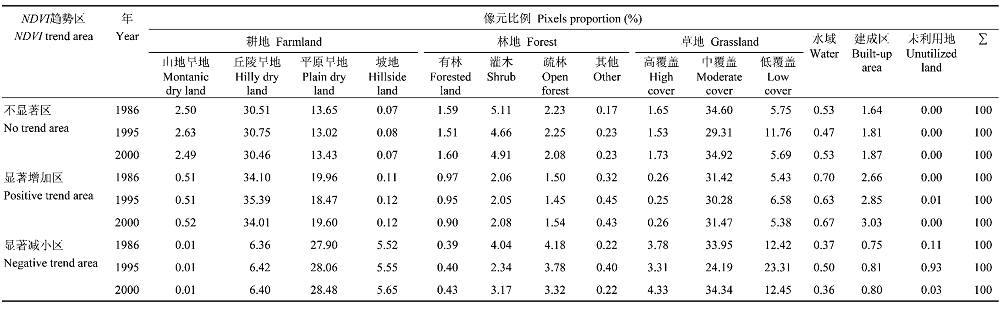 |
表2 归一化植被指数(NDVI)趋势不显著、显著增加、显著减小区土地利用类型变化
Table 2 Changes of the land use types in no trend area, positive area and negative area of normalized diference vegetation index (NDVI)
| |
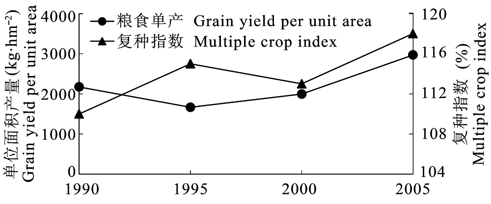
图4 泾河流域1990-2005年粮食单位面积产量和复种指数的变化(据耿艳辉等, 2008)。
Fig. 4 Changes of grain yield per unit area and multiple crop index in Jinghe River watershed from 1990 to 2005 (According to Geng et al., 2008).
| [1] | Alves Senna MC, Costa MH, Chipponelli Pinto LI, Acioli Imbuzeiro HM, Freitas Diniz LM, Pires GF (2009). Challenges to reproduce vegetation structure and dynamics in amazonia using a coupled climate-biosphere model. Earth Interactions, 13(11), 1-28. |
| [2] | Anderson RG, Goulden ML (2011). Relationships between climate, vegetation, and energy exchange across a montane gradient. Journal of Geophysical Research- Biogeosciences, 116, G01026. |
| [3] |
Anyamba A, Tucker CJ (2005). Analysis of Sahelian vegetation dynamics using NOAA-AVHRR NDVI data from 1981-2003. Journal of Arid Environments, 63, 596-614.
DOI URL |
| [4] | Betts RA, Cox PM, Lee SE, Woodward FI (1997). Contrasting physiological and structural vegetation feedbacks in climate change simulations. Nature, 387, 796-799. |
| [5] | Bi XL ( 毕晓丽), Wang H ( 王辉), Zhou R ( 周睿), Hong J ( 洪军), Suo AN ( 索安宁), Ge JP ( 葛剑平) (2006). Analysis on the livestock capability of the Jinghe River basin on the Loess Plateau. Acta Ecologica Sinica (生态学报), 26, 4219-4224. (in Chinese with English abstract) |
| [6] |
Boelman NT, Stieglitz M, Griffin KL, Shaver GR (2005). Inter-annual variability of NDVI in response to long-term warming and fertilization in wet sedge and tussock tundra. Oecologia, 143, 588-597.
DOI URL PMID |
| [7] |
Chen CC ( 陈操操), Xie GD ( 谢高地), Zhen L ( 甄霖), Geng YH ( 耿艳辉), Leng YF ( 冷允法) (2008). Analysis on Jinghe watershed vegetation dynamics and evaluation on its relation with precipitation. Acta Ecologica Sinica (生态学报), 28, 925-938. (in Chinese with English abstract)
DOI URL |
| [8] | Chi HK ( 池宏康) (1995). A study on the model for estimation winter wheat yield using spectral data of wheat field. Acta Phytoecologica Sinica (植物生态学报), 19, 337-344. (in Chinese with English abstract) |
| [9] | Cramer W, Bondeau A, Woodward FI, Prentice IC, Betts RA, Brovkin V, Cox PM, Fisher V, Foley JA, Friend AD, Kucharik C, Lomas MR, Ramankutty N, Sitch S, Smith B, White A, Young-Molling C (2001). Global response of terrestrial ecosystem structure and function to CO2 and climate change: results from six dynamic global vegetation models. Global Change Biology, 7, 357-373. |
| [10] |
Diodato N, Bellocchi G (2008). Modelling vegetation greenness responses to climate variability in a mediterranean terrestrial ecosystem. Environmental Monitoring and Assessment, 143, 147-159.
URL PMID |
| [11] | Duchemin B, Guyon D, Lagouarde JP (1999). Potential and limits of NOAA-AVHRR temporal composite data for phenology and water stress monitoring of temperate forest ecosystems. International Journal of Remote Sensing, 20, 895-917. |
| [12] | Editorial Board of Vegetation Map of China, Chinese Academy of Sciences (中国科学院中国植被图编辑委员会) (2001). 1: 1000000 Vegetation Atlas of China (1: 1000000中国植被图集). Science Press, Beijing. (in Chinese) |
| [13] | Esteban-Parra MJ, Rodrigo FS, Castro-Diez Y (1998). Spatial and temporal patterns of precipitation in spain for the period 1880-1992. International Journal of Climatology, 18, 1557-1574. |
| [14] |
Evans J, Geerken R (2004). Discrimination between climate and human-induced dryland degradation. Journal of Arid Environments, 57, 535-554.
DOI URL |
| [15] |
Fuller DO (1998). Trends in NDVI time series and their relation to rangeland and crop production in Senegal, 1987-1993. International Journal of Remote Sensing, 19, 2013-2018.
DOI URL |
| [16] | Geng CX ( 耿春香), Zhang XX ( 张秀霞) (2003). Affecting factors analyze for ecological environment of oil field exploit in the Northwest. Environmental Protection Science (环境保护科学), 29, 40-41. (in Chinese with English abstract) |
| [17] | Geng YH ( 耿艳辉), Min QW ( 闵庆文), Cheng SK ( 成升魁), Chen CC ( 陈操操) (2008). Temporal and spatial distribu- tion of cropland-population-grain system and pressure index on cropland in Jinghe watershed. Transactions of the Chinese Society of Agricultural Engineering (农业工程学报), 24(10), 68-73. (in Chinese with English abstract) |
| [18] |
Goward SN, Waring RH, Dye DG, Yang JL (1994). Ecological remote sensing at OTTER: satellite macroscale observa- tions. Ecological Applications, 4, 322-343.
DOI URL |
| [19] | Guo ZH ( 郭志华), Peng SL ( 彭少麟), Wang BS ( 王伯荪), Zhang Z ( 张征) (1999). Estimation of radiation absorption by Guangdong vegetation using GIS and RS. Acta Ecologica Sinica (生态学报), 19, 441-447. (in Chinese with English abstract) |
| [20] | Holben BN (1986). Characteristics of maximum-value composite images from temporal AVHRR data. Interna- tional Journal of Remote Sensing, 7, 1417-1434. |
| [21] |
Jeong SJ, Ho CH, Park TW, Kim J, Levis S (2011). Impact of vegetation feedback on the temperature and its diurnal range over the Northern Hemisphere during summer in a 2 × CO2 climate. Climate Dynamics, 37, 821-833.
DOI URL |
| [22] | Jiang D ( 江东), Wang NB ( 王乃斌), Yang XH ( 杨小唤), Liu HH ( 刘红辉) (2002). Principles of the interaction between NDVI profile and the growing situation of crops. Acta Ecologica Sinica (生态学报), 22, 247-253. (in Chinese with English abstract) |
| [23] | Jobbagy EG, Sala OE, Paruelo JM (2002). Patterns and controls of primary production in the patagonian steppe: a remote sensing approach: regional ecological analysis. Ecology, 83, 307-319. |
| [24] | Kepner WG, Rubio JL, Mouat DA, Pedrazzini F (2006). Desertification in the Mediterranean Region: a Security Issue. Springer, Dordrecht, The Netherlands. 614. |
| [25] |
Law BE, Waring RH (1994). Remote-sensing of leaf area index and radiation intercepted by understory vegetation. Ecological Applications, 4, 272-279.
DOI URL |
| [26] | Li BG ( 李本纲), Tao S ( 陶澍) (2000). Correlation between AVHRR NDVI and climate factors. Acta Ecologica Sinica (生态学报), 20, 898-902. (in Chinese with English abstract) |
| [27] |
Liu JY, Zhang ZX, Xu XL, Kuang WH, Zhou WC, Zhang SW, Li RD, Yan CZ, Yu DS, Wu SX, Nan J (2010). Spatial patterns and driving forces of land use change in China during the early 21st century. Journal of Geographical Sciences, 20, 483-494.
DOI URL |
| [28] |
Liu XC, Xu ZX, Yu RH (2011). Trend of climate variability in China during the past decades. Climatic Change, 109, 503-516.
DOI URL |
| [29] |
Lucht W, Prentice IC, Myneni RB, Sitch S, Friedlingstein P, Cramer W, Bousquet P, Buermann W, Smith B (2002). Climatic control of the high-latitude vegetation greening trend and pinatubo effect. Science, 296, 1687-1689.
URL PMID |
| [30] |
Ma MG ( 马明国), Wang J ( 王建), Wang XM ( 王雪梅) (2006). Advance in the inter-annual variability of vegetation and its relation to climate based on remote sensing. Journal of Remote Sensing (遥感学报), 10, 421-431. (in Chinese with English abstract)
DOI URL |
| [31] | Milich L, Weiss E (2000). GAC NDVI images: relationship to rainfall and potential evaporation in the grazing lands of the gourma (northern Sahel) and in the croplands of the Niger-Nigeria border (southern Sahel). International Journal of Remote Sensing, 21, 261-280. |
| [32] |
Monteith JL (1981). Climatic variation and the growth of crops. Quarterly Journal of the Royal Meteorological Society, 107, 749-774.
DOI URL |
| [33] |
Morawitz DF, Blewett TM, Cohen A, Alberti M (2006). Using NDVI to assess vegetative land cover change in central Puget Sound. Environmental Monitoring and Assessment, 114, 85-106.
URL PMID |
| [34] |
Nemani RR, Keeling CD, Hashimoto H, Jolly WM, Piper SC, Tucker CJ, Myneni RB, Running SW (2003). Climate- driven increases in global terrestrial net primary production from 1982 to 1999. Science, 300, 1560-1563.
URL PMID |
| [35] |
Ostwald M, Chen DL (2006). Land-use change: impacts of climate variations and policies among small-scale farmers in the Loess Plateau, China. Land Use Policy, 23, 361-371.
DOI URL |
| [36] | Piao SL, Fang JY, Ji W, Guo QH, Ke JH, Tao S, Woods K (2004). Variation in a satellite-based vegetation index in relation to climate in China. Journal of Vegetation Science, 15, 219-226. |
| [37] | Qi Q ( 齐清), Wang TM ( 王天明), Kou XJ ( 寇晓军), Ge JP ( 葛剑平) (2009). Temporal and spatial changes of vegetation cover and the relationship with precipitation in Jinghe Watershed of China. Chinese Journal of Plant Ecology (植物生态学报), 33, 246-253. (in Chinese with English abstract) |
| [38] |
Slayback DA, Pinzon JE, Los SO, Tucker CJ (2003). Northern hemisphere photosynthetic trends 1982-99. Global Change Biology, 9, 1-15.
DOI URL |
| [39] | Sun XZ ( 孙新章), Xie GD ( 谢高地), Zhen L ( 甄霖) (2007). Effects of converting arable land into forest (grassland) and eco-compensation: a case study in Yuanzhou County, Guyuan City of Ningxia Hui Autonomous Region. Resources Science (资源科学), 29(2), 194-200. (in Chinese with English abstract) |
| [40] | Suo AN ( 索安宁), Zhao WZ ( 赵文喆), Wang TM ( 王天明), Yuan F ( 袁飞), Xiong Y ( 熊颖), Ge JP ( 葛剑平) (2007). Spatial-temporal succession characteristics of soil and water loss in the central Loess Plateau during the last 50 years. Journal of Beijing Forestry University (北京林业大学学报), 29(1), 90-97. (in Chinese with English abstract) |
| [41] | Tottrup C, Rasmussen MS (2004). Mapping long-term changes in savannah crop productivity in Senegal through trend analysis of time series of remote sensing data. Agriculture, Ecosystems and Environment, 103, 545-560. |
| [42] |
Verburg PH (2006). Simulating feedbacks in land use and land cover change models. Landscape Ecology, 21, 1171-1183.
DOI URL |
| [43] |
Vermote E, Saleoup NE, Kaufman YJ, Duttonc E (1997). Data pre-processing: stratospheric aerosol perturbing effect on the remote sensing of vegetation: correction method for the composite NDVI after the pinatubo eruption. Remote Sensing Reviews, 15, 7-21.
DOI URL |
| [44] | Vermote EF, Saleous NE (1995). Stratospheric aerosol perturb- ing effect on the remote sensing of vegetation: operational method for the correction of AVHRR composite NDVI. Atmospheric Sensing and Modelling, 2311, 19-29. |
| [45] | Wang CY ( 王长耀), Luo CF ( 骆成凤), Qi SH ( 齐述华), Niu Z ( 牛铮) (2005). A method of land cover classification for China based on NDVI-Ts space. Journal of Remote Sensing (遥感学报), 9, 93-99. (in Chinese with English abstract) |
| [46] | Wang TY ( 王天永) (1993). Potential danger and prevention countermeasures of soil erosion in Liupanshan and Ziwuling woodland. Soil and Water Conservation in China (中国水土保持), 7, 46-48. (in Chinese) |
| [47] | Wessels KJ, Prince SD, Malherbe J, Small J, Frost PE, VanZyl D (2007). Can human-induced land degradation be distinguished from the effects of rainfall variability? A case study in South Africa. Journal of Arid Environments, 68, 271-297. |
| [48] |
Wessels KJ, Prince SD, Zambatis N, MacFadyen S, Frost PE, VanZyl D (2006). Relationship between herbaceous biomass and 1-km 2 Advanced Very High Resolution Radiometer (AVHRR) NDVI in Kruger National Park, South Africa. International Journal of Remote Sensing, 27, 951-973.
DOI URL |
| [49] | Xie GD ( 谢高地), Zhen L ( 甄霖), Chen CC ( 陈操操), Yang L ( 杨丽) (2007). The changes and their interactions of precipitation-landscape-runoff in Jinghe Watershed. Resources Science (资源科学), 29(2), 156-163. (in Chinese with English abstract) |
| [50] |
Xie GD ( 谢高地), Zhen L ( 甄霖), Yang L ( 杨丽), Guo GM ( 郭广猛) (2005). Landscape stability and its pattern transition in Jinghe Watershed. Chinese Journal of Applied Ecology (应用生态学报), 16, 1693-1698. (in Chinese with English abstract)
URL PMID |
| [51] | Xin ZB ( 信忠保), Xu JX ( 许炯心) (2007). Response of spatio-temporal variation of vegetation cover to climate change in Loess Plateau. Progress in Natural Science (自然科学进展), 17, 770-778. (in Chinese) |
| [52] | Xin ZB ( 信忠保), Xu JX ( 许炯心), Zheng W ( 郑伟) (2007). Effect of climate change and human activities on the vegetation cover in Loess Plateau. Science in China (Series D: Earth Sciences) (中国科学(D辑: 地球科学)), 37, 1504-1514. (in Chinese) |
| [53] | Yang L ( 杨丽), Xie GD ( 谢高地), Zhen L ( 甄霖), Leng YF ( 冷允法), Guo GM ( 郭广猛) (2005). Spatio-temporal changes of land use in Jinghe Watershed. Resources Science (资源科学), 27(4), 26-32. (in Chinese with English abstract) |
| [54] | Zhen L ( 甄霖), Xie GD ( 谢高地), Yang L ( 杨丽), Chen CC ( 陈操操), Guo GM ( 郭广猛), Liu XL ( 刘雪林) (2007a). Interactions between human activities and landuse patterns, and conflicts at the village level of Jinghe Watershed. Resources Science (资源科学), 29(2), 201-207. (in Chinese with English abstract) |
| [55] | Zhen L ( 甄霖), Xie GD ( 谢高地), Yang L ( 杨丽), Cheng SK ( 成升魁) (2007b). Challenges facing landscape manage- ment in the Jinghe Watershed of northwestern China by using participatory rural appraisal. China Population Resources and Environment (中国人口·资源与环境), 17(3), 129-133. (in Chinese with English abstract) |
| [1] | 张智洋 赵颖慧 甄贞. 1986-2022年松花江流域陆地生态系统碳储量动态监测[J]. 植物生态学报, 2024, 48(预发表): 0-0. |
| [2] | 陈以恒 玉素甫江·如素力 阿卜杜热合曼·吾斯曼. 2001-2020年天山新疆段草地植被覆盖度时空变化及驱动因素分析[J]. 植物生态学报, 2024, 48(5): 561-576. |
| [3] | 张计深, 史新杰, 刘宇诺, 吴阳, 彭守璋. 气候变化下中国潜在自然植被生态系统碳储量动态[J]. 植物生态学报, 2024, 48(4): 428-444. |
| [4] | 臧妙涵, 王传宽, 梁逸娴, 刘逸潇, 上官虹玉, 全先奎. 基于纬度移栽的落叶松叶、枝、根生态化学计量特征对气候变暖的响应[J]. 植物生态学报, 2024, 48(4): 469-482. |
| [5] | 梁逸娴, 王传宽, 臧妙涵, 上官虹玉, 刘逸潇, 全先奎. 落叶松径向生长和生物量分配对气候变暖的响应[J]. 植物生态学报, 2024, 48(4): 459-468. |
| [6] | 吴茹茹, 刘美珍, 谷仙, 常馨月, 郭立月, 蒋高明, 祁如意. 气候变化对巨柏适宜生境分布的潜在影响和预测[J]. 植物生态学报, 2024, 48(4): 445-458. |
| [7] | 秦文宽, 张秋芳, 敖古凯麟, 朱彪. 土壤有机碳动态对增温的响应及机制研究进展[J]. 植物生态学报, 2024, 48(4): 403-415. |
| [8] | 杨宇萌, 来全, 刘心怡. 气候变化和人类活动对内蒙古植被总初级生产力的定量影响[J]. 植物生态学报, 2024, 48(3): 306-316. |
| [9] | 张启, 程雪寒, 王树芝. 北京西山老龄树记载的森林干扰历史[J]. 植物生态学报, 2024, 48(3): 341-348. |
| [10] | 吴瀚, 白洁, 李均力, 古丽•加帕尔, 包安明. 新疆地区植被覆盖度时空变化及其影响因素分析[J]. 植物生态学报, 2024, 48(1): 41-55. |
| [11] | 白雨鑫, 苑丹阳, 王兴昌, 刘玉龙, 王晓春. 东北地区3种桦木木质部导管特征对气候变化响应的趋同与差异[J]. 植物生态学报, 2023, 47(8): 1144-1158. |
| [12] | 冯珊珊, 黄春晖, 唐梦云, 蒋维昕, 白天道. 细叶云南松针叶形态和显微性状地理变异及其环境解释[J]. 植物生态学报, 2023, 47(8): 1116-1130. |
| [13] | 余继梅, 吴福忠, 袁吉, 金遐, 魏舒沅, 袁朝祥, 彭艳, 倪祥银, 岳楷. 全球尺度上凋落物初始酚类含量特征及影响因素[J]. 植物生态学报, 2023, 47(5): 608-617. |
| [14] | 赵小祥, 朱彬彬, 田秋香, 林巧玲, 陈龙, 刘峰. 叶片凋落物分解的主场优势研究进展[J]. 植物生态学报, 2023, 47(5): 597-607. |
| [15] | 任培鑫, 李鹏, 彭长辉, 周晓路, 杨铭霞. 洞庭湖流域植被光合物候的时空变化及其对气候变化的响应[J]. 植物生态学报, 2023, 47(3): 319-330. |
| 阅读次数 | ||||||
|
全文 |
|
|||||
|
摘要 |
|
|||||
Copyright © 2026 版权所有 《植物生态学报》编辑部
地址: 北京香山南辛村20号, 邮编: 100093
Tel.: 010-62836134, 62836138; Fax: 010-82599431; E-mail: apes@ibcas.ac.cn, cjpe@ibcas.ac.cn
备案号: 京ICP备16067583号-19
![]()