
植物生态学报 ›› 2024, Vol. 48 ›› Issue (1): 41-55.DOI: 10.17521/cjpe.2022.0397 cstr: 32100.14.cjpe.2022.0397
吴瀚1,2,3, 白洁1,3,*( ), 李均力1,3, 古丽•加帕尔1,3, 包安明1,3
收稿日期:2022-10-10
接受日期:2023-03-19
出版日期:2024-01-20
发布日期:2023-06-15
通讯作者:
*(baijie@ms.xjb.ac.cn)基金资助:
WU Han1,2,3, BAI Jie1,3,*(), LI Jun-Li1,3, Guli JIAPAER1,3, BAO An-Ming1,3
Received:2022-10-10
Accepted:2023-03-19
Online:2024-01-20
Published:2023-06-15
Supported by:摘要:
新疆作为我国西北生态安全屏障的核心区域, 生态环境状况和质量的格局变化和影响机制一直备受关注。该研究基于2003-2020年MODIS地表反照率数据集(MOD09 A1), 利用改进的三梯度差法获取植被覆盖度(FVC), 运用线性回归、偏相关分析、Tukey检验等多种统计方法, 探讨新疆地区FVC时空变化规律及定量温度、降水量与地下水储量对其的贡献。主要结果: (1)近18年新疆地区平均FVC由20.08%提高到21.76%, 整体呈增长趋势(增速为0.19%·a-1), 且2008年以后呈快速增长阶段; 其中, 耕地增速最大(0.66%·a-1), 稀疏草地增速最慢(0.11%·a-1)。(2)温度是新疆生长季FVC的重要影响因素, 温度对FVC影响集中在春季和秋季; 而降水量和地下水储量是夏季FVC的主要影响因素。(3)夏季地下水储量是灌丛和耕地FVC的最主要影响因素; 夏季降水量对草地FVC的影响最大, 而夏季地下水储量对稀疏草地FVC的影响较大。(4)温度对新疆FVC的影响随湿润程度增加而减弱, 而降水量的影响则随之增强; 地下水储量影响随湿润程度增加呈先增加后减少趋势。该研究结果可为新疆生态恢复和建设提供科学理论依据, 对于推动新疆的生态文明建设和绿色可持续发展具有重要意义。
吴瀚, 白洁, 李均力, 古丽•加帕尔, 包安明. 新疆地区植被覆盖度时空变化及其影响因素分析. 植物生态学报, 2024, 48(1): 41-55. DOI: 10.17521/cjpe.2022.0397
WU Han, BAI Jie, LI Jun-Li, Guli JIAPAER, BAO An-Ming. Study of spatio-temporal variation in fractional vegetation cover and its influencing factors in Xinjiang, China. Chinese Journal of Plant Ecology, 2024, 48(1): 41-55. DOI: 10.17521/cjpe.2022.0397
| 土地利用类型 Land use type | 主要组成 Main components |
|---|---|
| 林地 Forestland | 常绿针叶林 Evergreen coniferous forest |
| 落叶阔叶林 Deciduous broadleaf forest | |
| 落叶针叶林 Deciduous coniferous forest | |
| 乔木园地 Tree orchard | |
| 乔木绿地 Tree garden | |
| 稀疏林 Sparse forest | |
| 灌丛 Shrubland | 落叶阔叶灌木林 Deciduous broadleaf shrub forest |
| 常绿针叶灌木林 Evergreen coniferous shrub forest | |
| 灌木园地 Shrub orchard | |
| 灌木绿地 Shrub garden | |
| 稀疏灌木林 Sparse shrub forest | |
| 草地 Grassland | 草甸 Meadow |
| 草原 Steppe | |
| 草本绿地 Lawn | |
| 稀疏草地 Sparse grassland | 稀疏草地 Sparse grassland |
| 耕地 Cropland | 旱地 Dry farmland |
| 水田 Paddy field | |
| 水体 Waterbody | 河流 River |
| 湖泊 Lake | |
| 水库/坑塘 Reservoir/pond | |
| 运河/水渠 Canal/channel | |
| 冰川 Glacier | 冰川/永久积雪 Permanent ice/snow |
| 人工地表 Built-up land | 采矿场 Mining field |
| 工业用地 Industrial field | |
| 交通用地 Transportation field | |
| 居住地 Settlement | |
| 裸地 Bare land | 裸土 Bare soil |
| 裸岩 Bare rock | |
| 沙漠/沙地 Desert | |
| 盐碱地 Salina |
表1 新疆主要土地利用类型及其主要组成
Table 1 Main land use types in Xinjiang and their main components
| 土地利用类型 Land use type | 主要组成 Main components |
|---|---|
| 林地 Forestland | 常绿针叶林 Evergreen coniferous forest |
| 落叶阔叶林 Deciduous broadleaf forest | |
| 落叶针叶林 Deciduous coniferous forest | |
| 乔木园地 Tree orchard | |
| 乔木绿地 Tree garden | |
| 稀疏林 Sparse forest | |
| 灌丛 Shrubland | 落叶阔叶灌木林 Deciduous broadleaf shrub forest |
| 常绿针叶灌木林 Evergreen coniferous shrub forest | |
| 灌木园地 Shrub orchard | |
| 灌木绿地 Shrub garden | |
| 稀疏灌木林 Sparse shrub forest | |
| 草地 Grassland | 草甸 Meadow |
| 草原 Steppe | |
| 草本绿地 Lawn | |
| 稀疏草地 Sparse grassland | 稀疏草地 Sparse grassland |
| 耕地 Cropland | 旱地 Dry farmland |
| 水田 Paddy field | |
| 水体 Waterbody | 河流 River |
| 湖泊 Lake | |
| 水库/坑塘 Reservoir/pond | |
| 运河/水渠 Canal/channel | |
| 冰川 Glacier | 冰川/永久积雪 Permanent ice/snow |
| 人工地表 Built-up land | 采矿场 Mining field |
| 工业用地 Industrial field | |
| 交通用地 Transportation field | |
| 居住地 Settlement | |
| 裸地 Bare land | 裸土 Bare soil |
| 裸岩 Bare rock | |
| 沙漠/沙地 Desert | |
| 盐碱地 Salina |
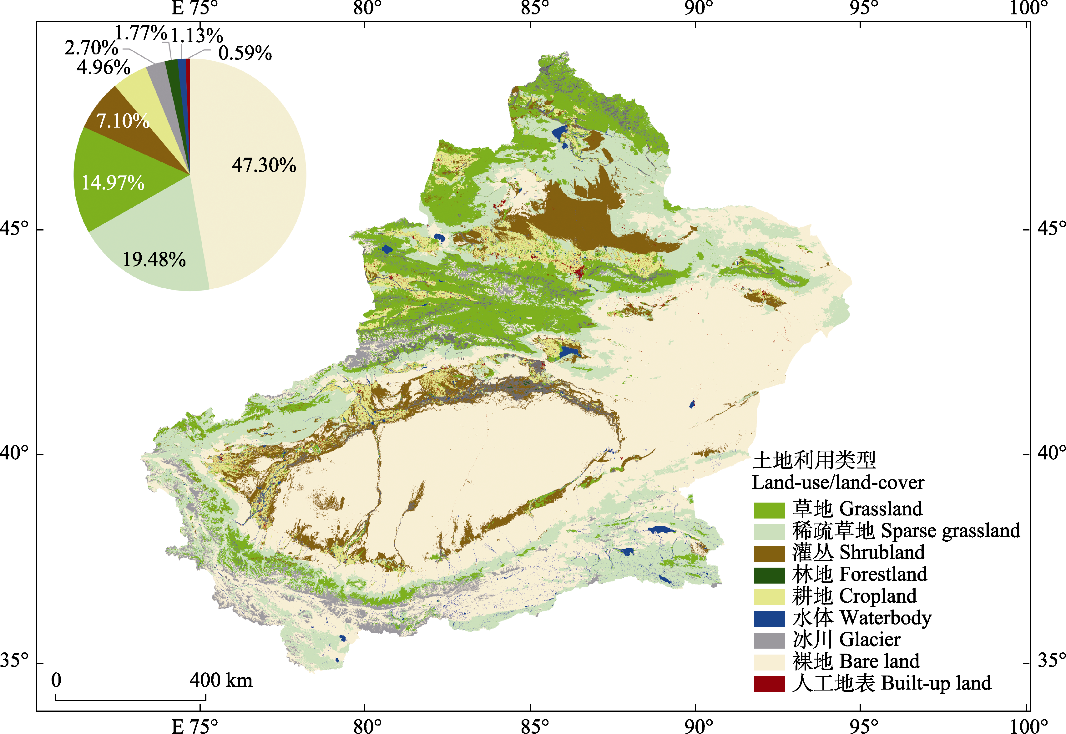
图1 新疆土地利用类型分布。
Fig. 1 Distribution of land-use in Xinjiang.
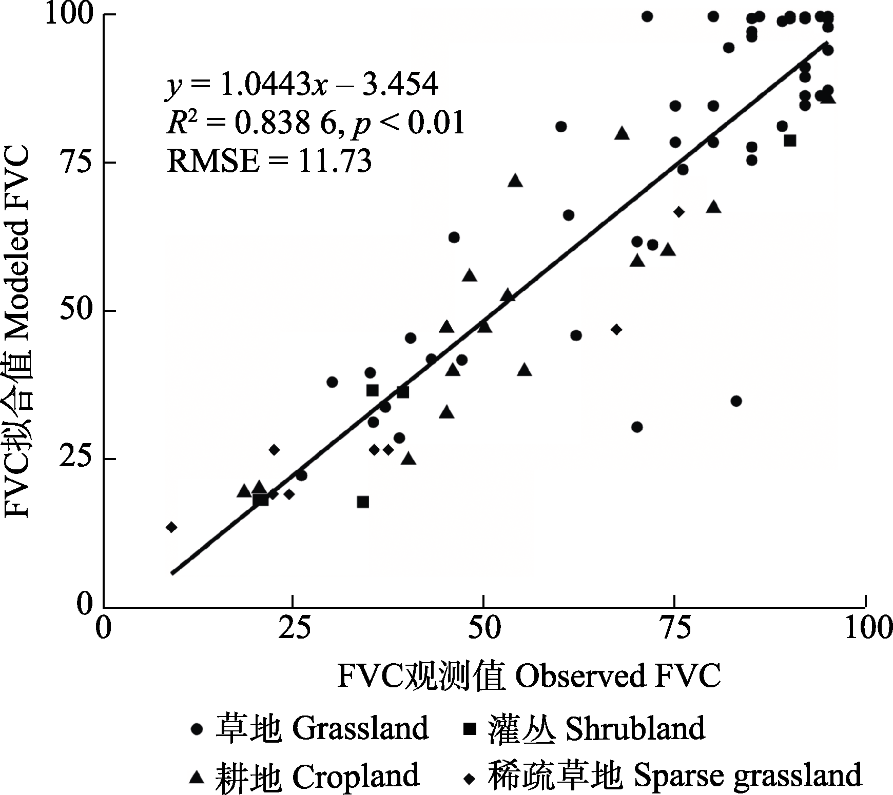
图2 植被覆盖度观测值与拟合值比较。RMSE, 均方根误差。
Fig. 2 Comparison of fractional vegetation cover between observed data and modelled data. RMSE, root mean square error.
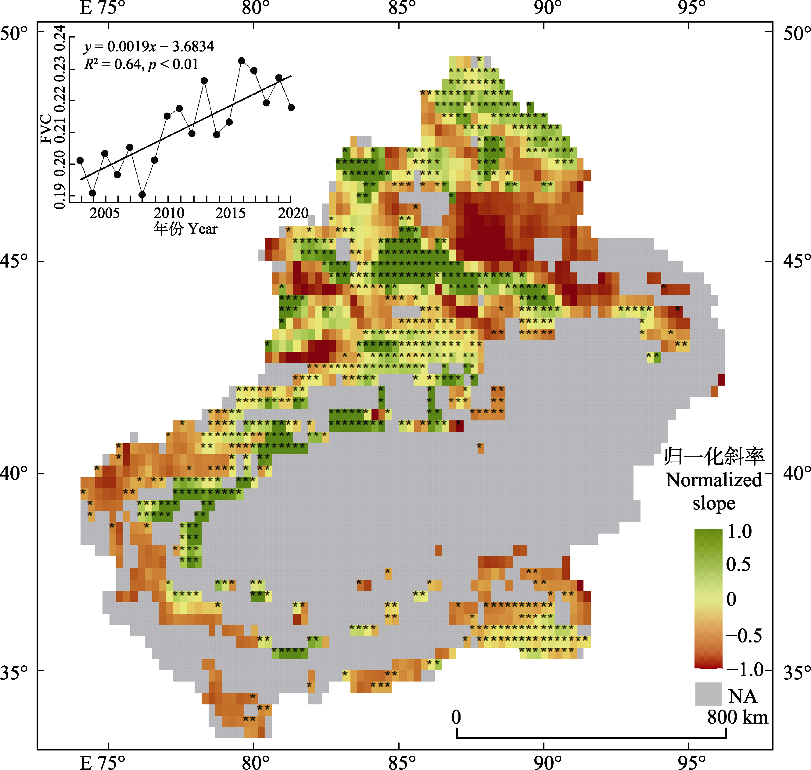
图3 2003-2020年新疆植被区植被覆盖度(FVC)时空变化。绿色代表FVC呈增加趋势, 红色代表FVC呈减少趋势, *代表变化趋势通过了p < 0.05的显著性水平检验。NA, 非植被覆盖区或未通过显著性检验。
Fig. 3 Spatio-temporal variation of fractional vegetation cover (FVC) in the vegetation covered area of Xinjiang from 2003 to 2020. Green pixels represent the increasing area of FVC, red pixels represent the decreasing area of FVC, and * represent the trend has passed the significance test of p < 0.05. NA, no vegetation covered area or area that fails the significance test.
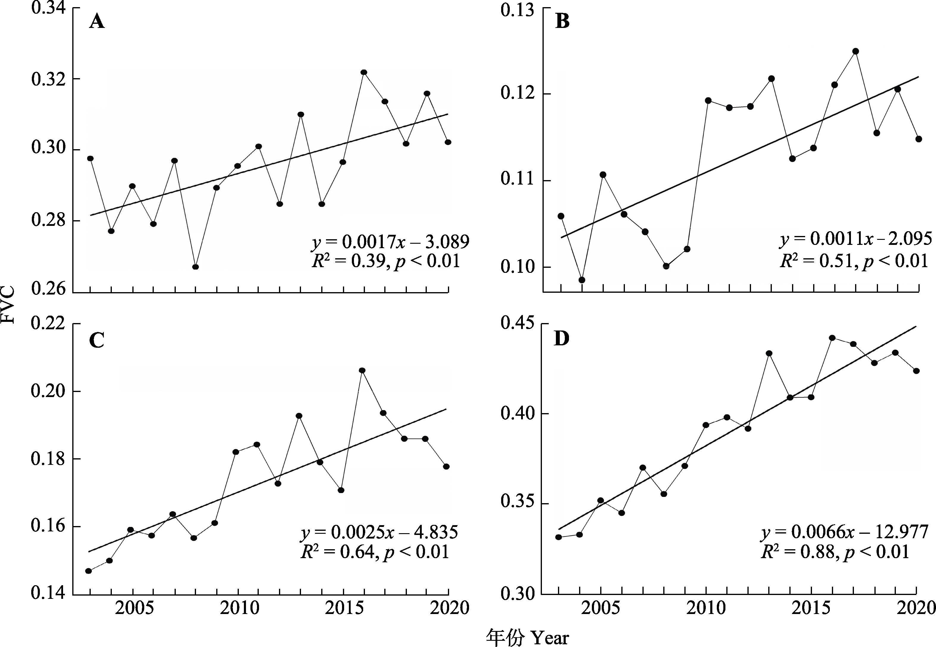
图4 2003-2020年新疆草地(A)、稀疏草地(B)、灌丛(C)和耕地(D)的植被覆盖度(FVC)变化。
Fig. 4 Fractional vegetation cover (FVC) variation of grassland (A), sparse grassland (B), shrubland (C) and cropland (D) in Xinjiang from 2003 to 2020.
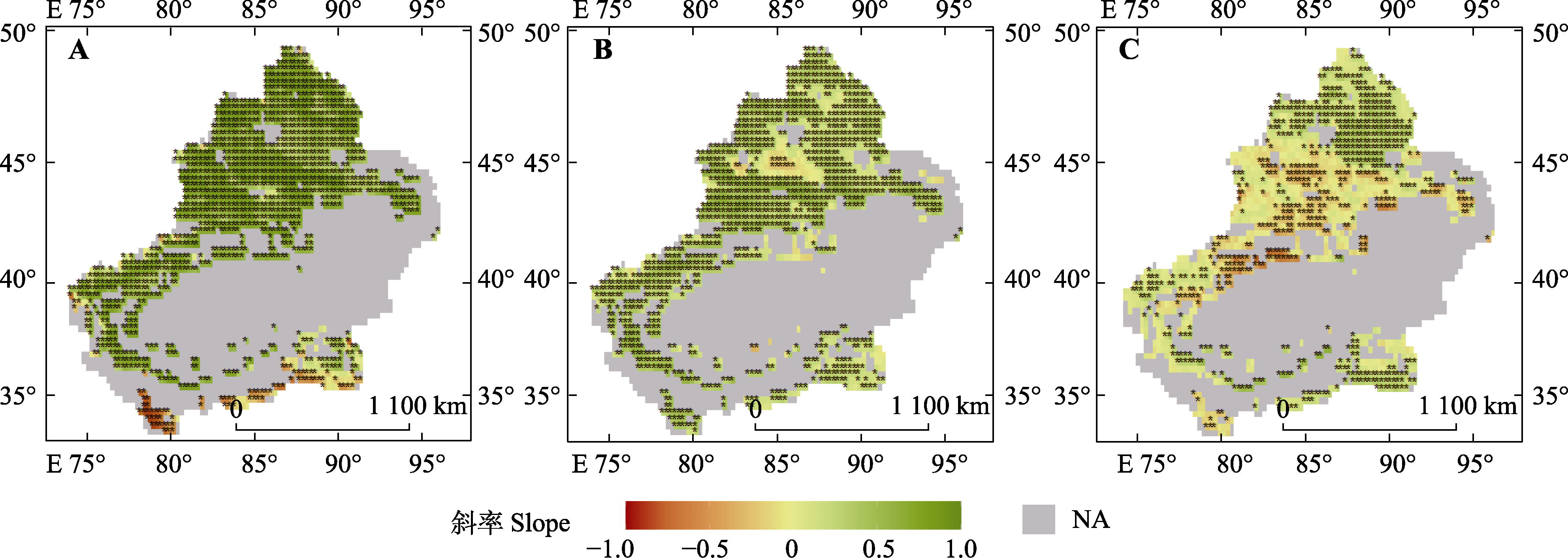
图5 2003-2020年新疆植被区植被覆盖度与温度(A)、降水量(B)和地下水储量(C)的偏相关系数。*代表变化趋势通过了p < 0.05的显著性水平检验。NA, 非植被覆盖区或未通过显著性检验。
Fig. 5 Partial correlation coefficient between fractional vegetation cover and temperature (A), precipitation (B) and groundwater storage (C) in the vegetation covered area of Xinjiang from 2003 to 2020. * represent the trend has passed the significance test of p < 0.05. NA, no vegetation covered area or area that fails the significance test.
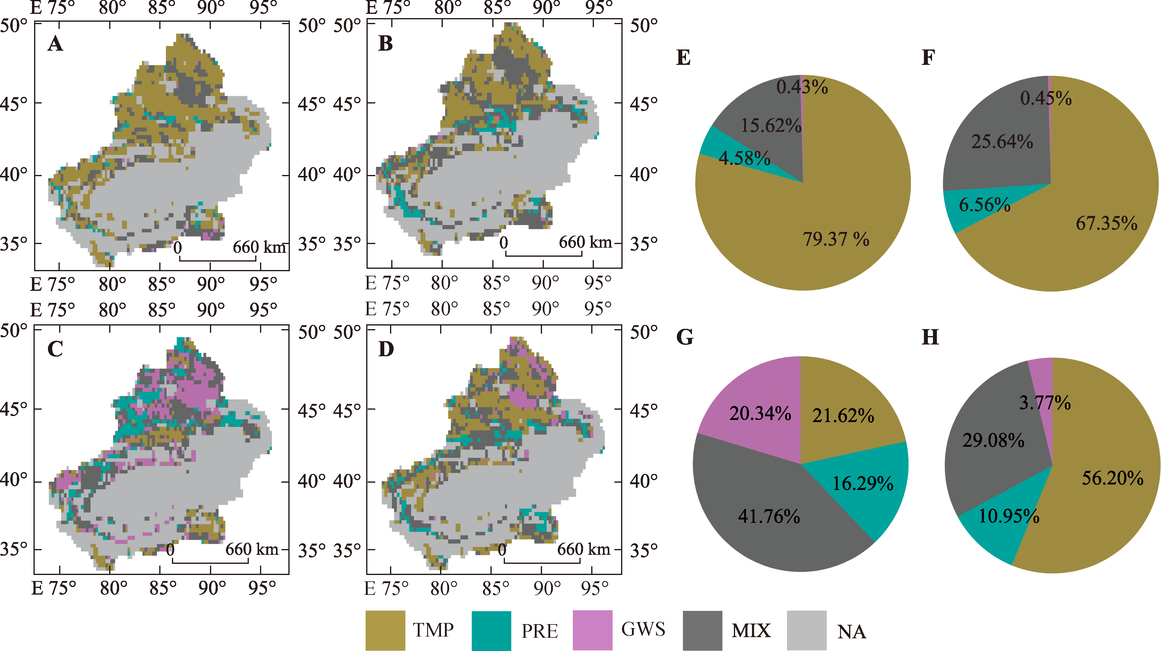
图6 2003-2020年新疆不同时期内植被覆盖度变化的主要环境影响因子的空间分布及占比饼图。A、E, 生长季(4-10月)。B、F, 春季(4-5月)。C、G, 夏季(6-8月)。D、H, 秋季(9-10月)。彩色覆盖区域代表某种环境影响因子与植被覆盖度的偏相关系数绝对值大于0.5。GWS, 地下水储量; MIX, 没有主导的影响因子(即: 3种因子与植被覆盖度的偏相关系数绝对值均小于0.5); NA, 非植被覆盖区或未通过显著性检验; PRE, 降水量; TMP, 温度。
Fig. 6 Spatial distribution and proportion of main influencing factors of fractional vegetation cover change in different periods of Xinjiang from 2003 to 2020. A, E, Growing season (Apr. to Oct.). B, F, Spring (Apr. to May). C, G, Summer (June to Aug.). D, H, Autumn (Sept. to Oct.). The colored area represents that the absolute value of partial correlation coefficient between one type of influencing factor and fractional vegetation cover is greater than 0.5. GWS, groundwater storage; MIX, no dominant influencing factor (that is, the absolute value of partial correlation coefficient is less than 0.5); NA, no vegetation covered area or area that fails the significance test; PRE, precipitation; TMP, temperature.
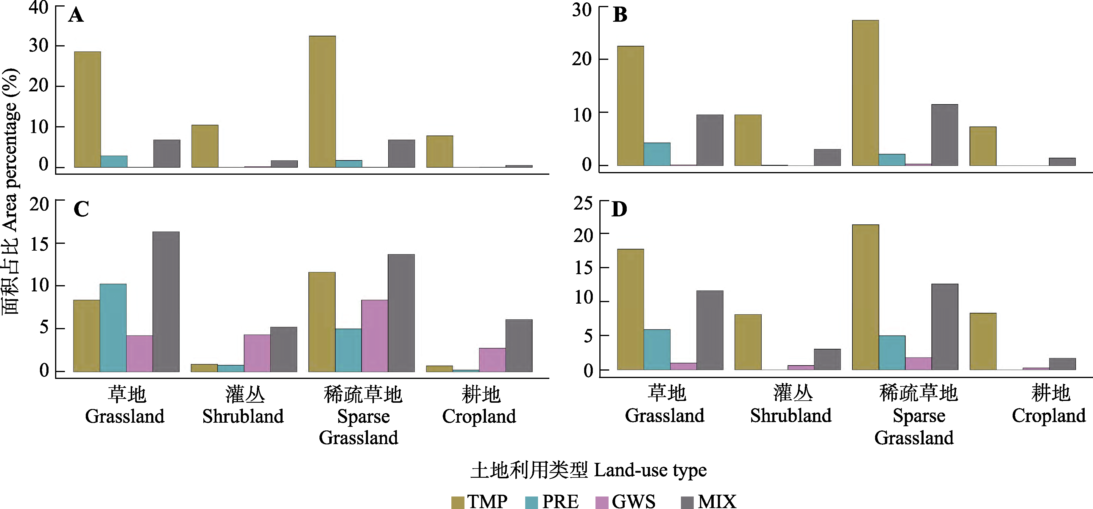
图7 2003-2020年新疆不同土地利用类型植被覆盖度变化的环境影响因子面积占比。A, 生长季(4-10月)。B, 春季(4-5月)。C, 夏季(6-8月)。D, 秋季(9-10月)。GWS, 地下水储量; MIX, 没有主导的影响因子; PRE, 降水量; TMP, 温度。
Fig. 7 Proportion of main influencing factors of changes in fractional vegetation cover of vegetation types in Xinjiang from 2003 to 2020. A, Growing season (Apr. to Oct.). B, Spring (Apr. to May). C, Summer (June to Aug.). D, Autumn (Sept. to Oct.). GWS, underground water reserves; MIX, no dominant impact factors; PRE, precipitation; TMP, temperature.
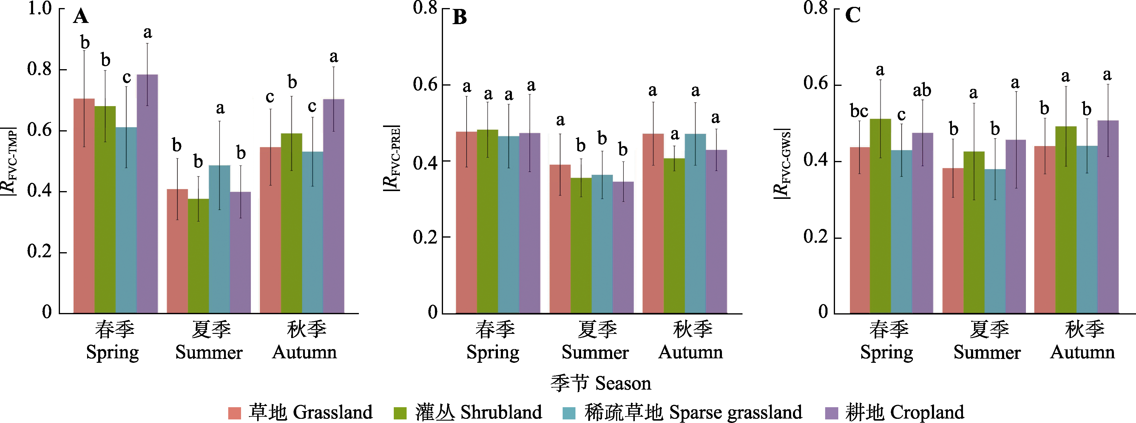
图8 2003-2020年新疆春季、夏季、秋季环境影响因子与植被覆盖度(FVC)偏相关系数(R)的绝对值(平均值±标准差)。A, 温度(TMP)。B, 降水量(PRE)。C, 地下水储量(GWS)。不同小写字母表示各种土地利用类型间差异显著(p < 0.05)。
Fig. 8 Absolute mean value of partial correlation coefficient (R) between environmental factors and fractional vegetation cover (FVC) in spring, summer and autumn of Xinjiang from 2003 to 2020 (mean ± SD). A, Temperature (TMP). B, Precipitation (PRE). C, Groundwater storage (GWS). Different lowercase letters indicate significant differences between different land use types (p < 0.05).
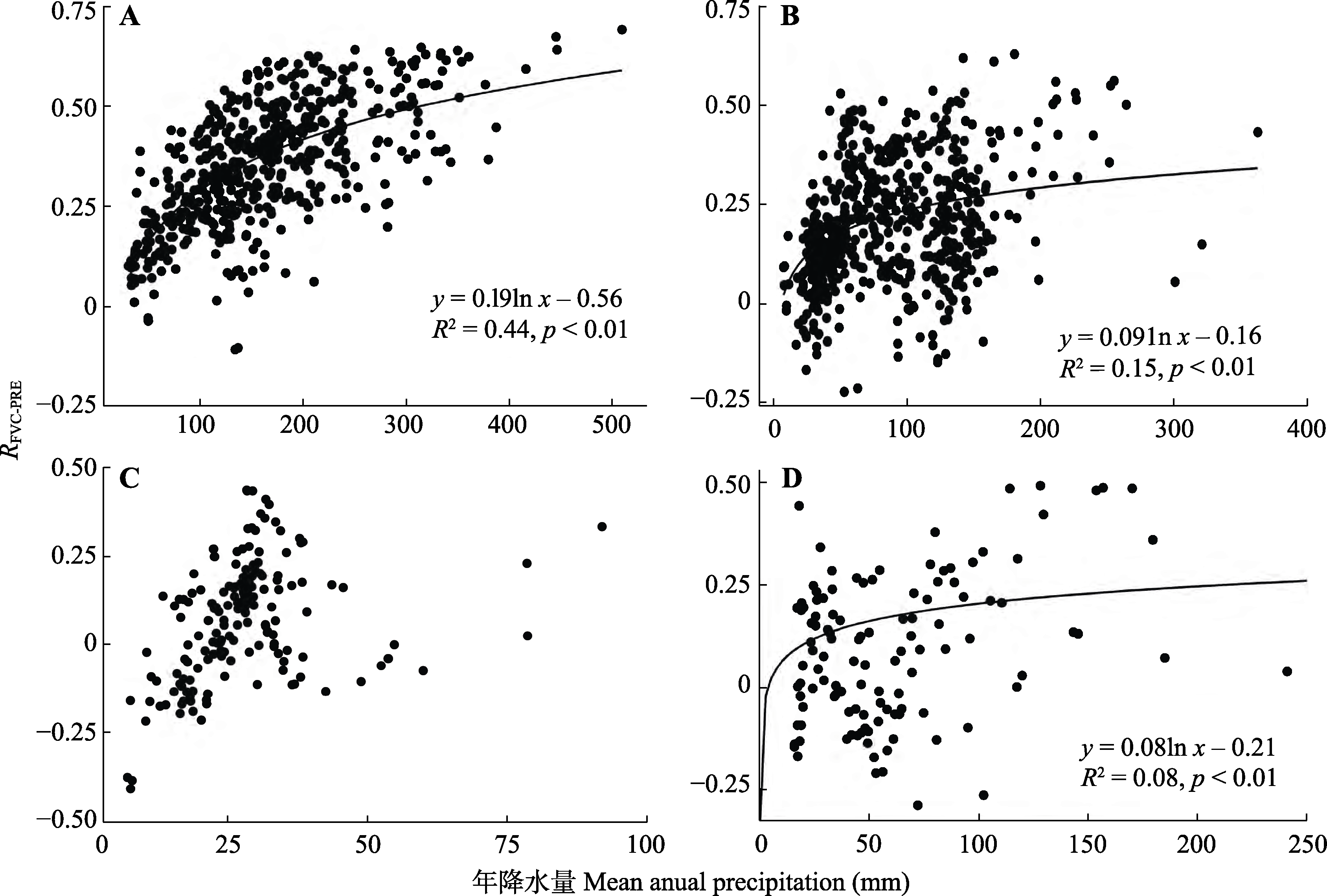
图9 2003-2020年降水量对新疆草地(A)、稀疏草地(B)、灌丛(C)和耕地(D)植被覆盖度(FVC)的影响与年降水量关系图。RFVC-PRE,植被覆盖度与降水量的偏相关系数。
Fig. 9 Relationship between mean annual precipitation and the influence of precipitation on fractional vegetation cover (FVC) of grassland (A), sparse grassland (B), shrubland (C) and cropland (D) in Xinjiang from 2003 to 2020. RFVC-PRE, the partial correlation coefficient between FVC and precipitation.
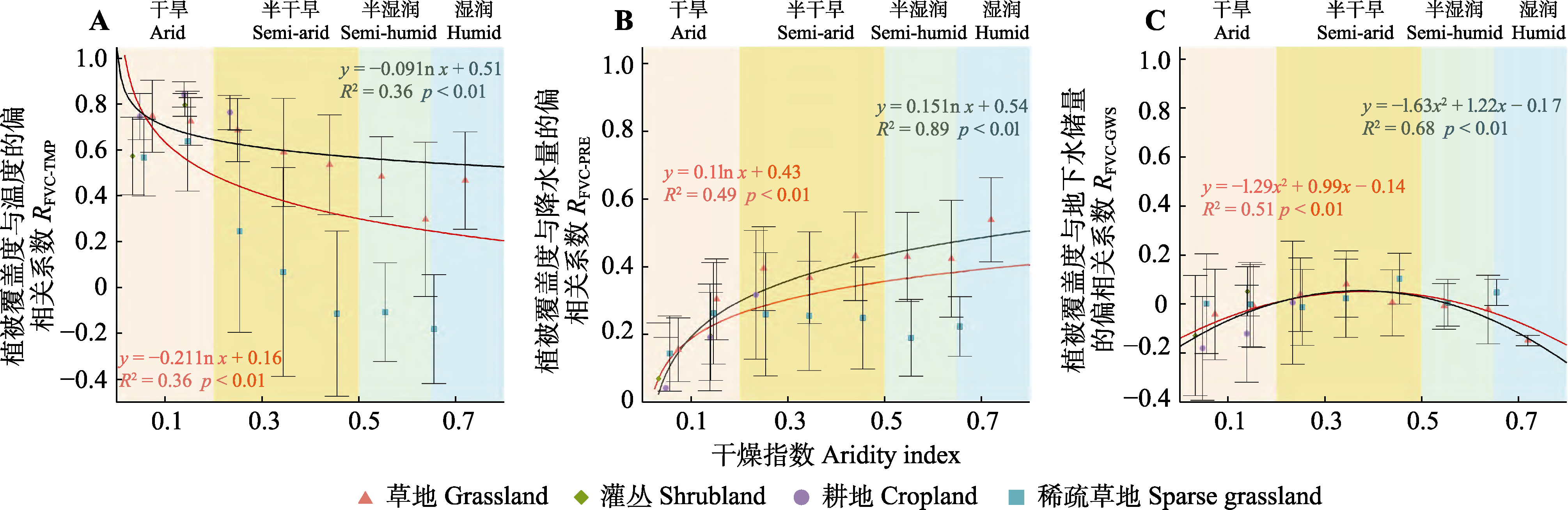
图10 2003-2020年新疆主要土地利用类型植被覆盖度(FVC)温度(A)、降水量(B)、地下水储量(C)的影响与干旱指数的关系图(平均值±标准差)。黑色线表示3种土地利用类型(草地、灌丛、耕地)的拟合结果, 红色表示4种土地利用类型(草地、稀疏草地、灌丛、耕地)的拟合结果。
Fig. 10 Relationship between fractional vegetation cover (FVC) influencing factors of main vegetation types in Xinjiang and aridity index from 2003 to 2020 (mean ± SD). A, Temperature. B, Precipitation. C, Groundwater storage. RFVC-TMP, RFVC-PRE and RFVC-GWS represent the partial correlation coefficient between fractional vegetation cover and temperature, precipitation and groundwater storage, respectively. The black curve represents the fitting results of three vegetation types (grassland, shrubland, cropland), and the red curve represents the fitting results of four vegetation types (grassland, sparse grassland, shrubland, cropland).
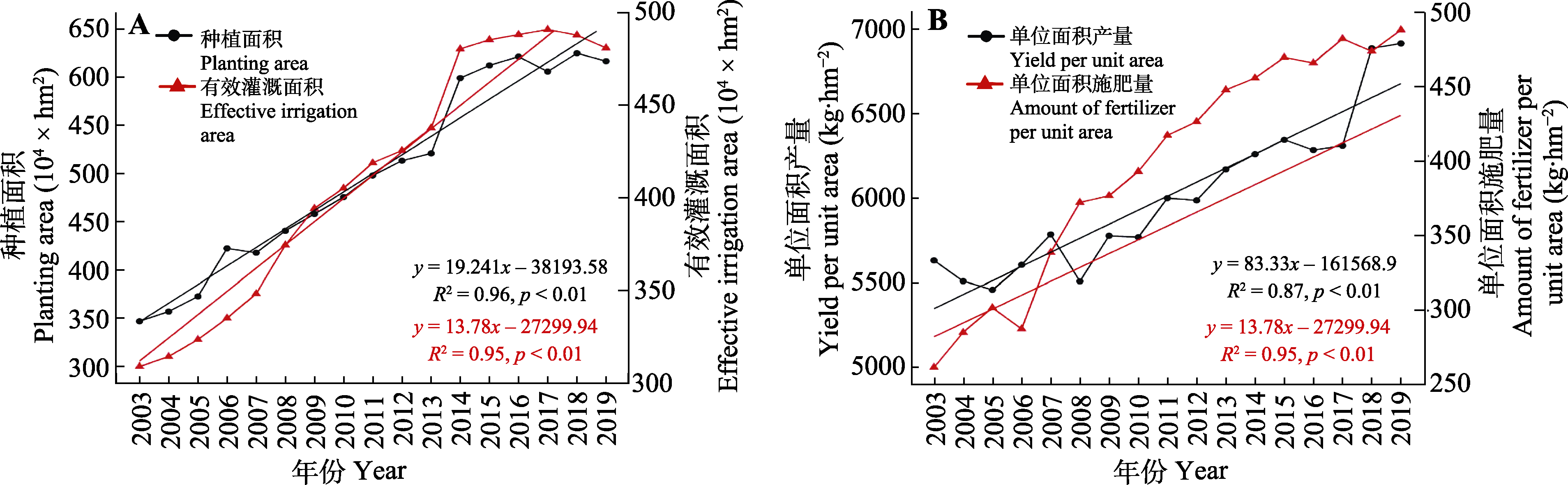
图11 2003-2019年新疆农业种植与管理变化趋势。
Fig. 11 Trends of agricultural planting and management in Xinjiang from 2003 to 2019.
| [1] | Bannari A, Asalhi H, Teillet PM (2002). Transformed difference vegetation index (TDVI) for vegetation cover mapping. IEEE International Geoscience and Remote Sensing Symposium, 5, 3053-3055. |
| [2] | Cai ZZ (2021). Grassland Cover Change and Their Response to Climate Change in Xinjiang. PhD dissertation, Beijing Forestry University, Beijing. |
| [蔡朝朝 (2021). 新疆草地覆盖变化及其对气候变化的响应. 博士学位论文, 北京林业大学, 北京.] | |
| [3] |
Chen C, Jing CQ, Xing WY, Deng XJ, Fu HY, Guo WZ (2021). Desert grassland dynamics in the last 20 years and its response to climate change in Xinjiang. Acta Prataculturae Sinica, 30, 1-14.
DOI |
|
[陈宸, 井长青, 邢文渊, 邓小进, 付皓宇, 郭文章 (2021). 近20年新疆荒漠草地动态变化及其对气候变化的响应. 草业学报, 30, 1-14.]
DOI |
|
| [4] | Chen X, Hu RJ, Jiang FQ, Wang YJ, Zhang JM (2015). Physical Geography of Arid Areas of China. Science Press, Beijing. |
| [陈曦, 胡汝骥, 姜逢清, 王亚俊, 张建明 (2015). 中国干旱区自然地理. 科学出版社, 北京.] | |
| [5] | Chen YH, Li XB, Shi PJ, Zhou HL (2001). Estimating vegetation coverage change using remote sensing data in Haidian district, Beijing. Acta Phytoecologica Sinica, 25, 588-593. |
| [陈云浩, 李晓兵, 史培军, 周海丽 (2001). 北京海淀区植被覆盖的遥感动态研究. 植物生态学报, 25, 588-593.] | |
| [6] | Cheng DN, Wang YQ, Cheng YX, Huang JF (2022). Vegetation-water vapor-land surface temperature correlation analysis of typical deserts and oases in Xinjiang. Arid Land Geography, 45, 456-466. |
| [程丹妮, 王颖琪, 程勇翔, 黄敬峰 (2022). 新疆典型沙漠和绿洲植被-水汽-地表温度相关性分析. 干旱区地理, 45, 456-466.] | |
| [7] | Ci H, Zhang Q (2017). Spatio-temporal patterns of NDVI variations and possible relations with climate changes in Xinjiang Province. Journal of Geo-Information Science, 19, 662-671. |
|
[慈晖, 张强 (2017). 新疆NDVI时空特征及气候变化影响研究. 地球信息科学学报, 19, 662-671.]
DOI |
|
| [8] | Cui C, Guo Y, Shen YJ (2021). Spatio-temporal variation in and the driving factors of desert vegetation in Xinjiang. Chinese Journal of Eco-Agriculture, 29, 1668-1678. |
| [崔灿, 郭英, 沈彦俊 (2021). 新疆荒漠植被的时空分布变化及其驱动因素. 中国生态农业学报, 29, 1668-1678.] | |
| [9] |
Du JQ, Shu JM, Yin JQ, Yuan XJ, Jiaerheng A, Xiong SS, He P, Liu WL (2015). Analysis on spatio-temporal trends and drivers in vegetation growth during recent decades in Xinjiang, China. International Journal of Applied Earth Observation and Geoinformation, 38, 216-228.
DOI URL |
| [10] |
Fan LL, Ma J, Wu LF, Xu GQ, Li Y, Tang LS (2012). Response of the herbaceous layer to snow variability at the south margin of the Gurbantonggut Desert of China. Chinese Journal of Plant Ecology, 36, 126-135.
DOI URL |
|
[范连连, 马健, 吴林峰, 徐贵青, 李彦, 唐立松 (2012). 古尔班通古特沙漠南缘草本层对积雪变化的响应. 植物生态学报, 36, 126-135.]
DOI |
|
| [11] |
Getirana A, Rodell M, Kumar S, Beaudoing HK, Arsenault K, Zaitchik B, Save H, Bettadpur S (2020). GRACE improves seasonal groundwater forecast initialization over the U.S. Journal of Hydrometeorology, 21, 59-71.
DOI PMID |
| [12] |
Gitelson AA, Kaufman YJ, Stark R, Rundquist D (2002). Novel algorithms for remote estimation of vegetation fraction. Remote Sensing of Environment, 80, 76-87.
DOI URL |
| [13] |
Gutman G, Ignatov A (1998). The derivation of the green vegetation fraction from NOAA/AVHRR data for use in numerical weather prediction models. International Journal of Remote Sensing, 19, 1533-1543.
DOI URL |
| [14] | Haq MA (2021). Intellligent sustainable agricultural water practice using multi sensor spatiotemporal evolution. Environmental Technology. DOI: 10.1080/09593330.2021.2005151. |
| [15] |
Jiapaer G, Chen X, Bao AM (2009). Coverage extraction and up-scaling of sparse desert vegetation in arid area. Chinese Journal of Applied Ecology, 20, 2925-2934.
PMID |
| [古丽·加帕尔, 陈曦, 包安明, (2009). 干旱区荒漠稀疏植被覆盖度提取及尺度扩展效应. 应用生态学报, 20, 2925-2934.] | |
| [16] | Jiang P, Ding WG, Xiao J, Pan XM (2021). Altitudinal difference of vegetation NPP and its response to climate change in Xinjiang. Arid Land Geography, 44, 849-857. |
| [姜萍, 丁文广, 肖静, 潘新民 (2021). 新疆植被NPP及其对气候变化响应的海拔分异. 干旱区地理, 44, 849-857.] | |
| [17] | Jiang P, Hu LQ, Xiao J, Kuerban Y (2022). Spatiotemporal dynamics of NDVI in Xinjiang and quantitative attribution based on geodetector. Research of Soil and Water Conservation, 29, 212-220. |
| [姜萍, 胡列群, 肖静, 雅森江·库尔班 (2022). 新疆植被NDVI时空变化及定量归因. 水土保持研究, 29, 212-220.] | |
| [18] | Li B, Rodell M, Zaitchik BF, Reichle RH, Koster RD, van Dam TM (2012). Assimilation of GRACE terrestrial water storage into a land surface model: evaluation and potential value for drought monitoring in western and central Europe. Journal of Hydrology, 446- 447, 103-115. |
| [19] | Li C, Wang RH, Cui XF, Wu F, Yan Y, Peng Q, Qian ZH, Xu Y (2021). Responses of vegetation spring phenology to climatic factors in Xinjiang, China. Ecological Indicators, 124, 107286. DOI: 10.1016/j.ecolind.2020.107286. |
| [20] | Li CE, Ma J, He Z (2022). Change characteristic analysis of natural vegetation coverage in Yili River valley. Geospatial Information, 20, 84-88. |
| [李春娥, 马静, 何芷 (2022). 伊犁河谷天然植被覆盖度的变化特征分析. 地理空间信息, 20, 84-88.] | |
| [21] | Li XT, Bai J, Li GL, Luo GP, Jiapaer G, Li JL (2013). Comparison of methods based on MODIS for estimating sparse vegetation fraction across desert in Xinjiang. Arid Land Geography, 36, 502-511. |
| [李向婷, 白洁, 李光录, 罗格平, 古丽·加帕尔, 李均力 (2013). 新疆荒漠稀疏植被覆盖度信息遥感提取方法比较. 干旱区地理, 36, 502-511.] | |
| [22] | Li Y, Yang RB, Wu GZ, Bi JP, Yi M, Hu WM (2015). Monitoring and analysis of vegetation fractional cover in Changsha-Zhuzhou-Xiangtan core region based on remote sensing data. Forest Research, 28, 265-270. |
| [李毅, 杨仁斌, 伍格致, 毕军平, 易敏, 胡文敏 (2015). 长株潭核心区植被覆盖度动态监测与分析. 林业科学研究, 28, 265-270.] | |
| [23] | Liu SS, Xu GQ, Mi XJ, Chen TQ, Li Y (2022). Effects of groundwater depth and seasonal drought on the physiology and growth of Haloxylon ammodendron at the southern edge of Gurbantonggut Desert. Acta Ecologica Sinica, 42, 8881-8891. |
| [刘深思, 徐贵青, 米晓军, 陈图强, 李彦 (2022). 地下水埋深和季节性干旱对古尔班通古特沙漠南缘梭梭生理和生长的影响. 生态学报, 42, 8881-8891.] | |
| [24] | Liu Y, Li CZ, Liu ZH, Deng XY (2016). Assessment of spatio-temporal variations in vegetation cover in Xinjiang from 1982 to 2013 based on GIMMS-NDVI. Acta Ecologica Sinica, 36, 6198-6208. |
| [刘洋, 李诚志, 刘志辉, 邓兴耀 (2016). 1982-2013年基于GIMMS-NDVI的新疆植被覆盖时空变化. 生态学报, 36, 6198-6208.] | |
| [25] | Ma YJ, Shi FZ, Hu X, Li XY (2021). Climatic constraints to monthly vegetation dynamics in desert areas over the silk road economic belt. Remote Sensing, 13, 995. DOI: 10.3390/rs13050995. |
| [26] |
Mu SJ, Li JL, Chen YZ, Gang CC, Zhou W, Ju WM (2012). Spatial differences of variations of vegetation coverage in inner Mongolia during 2001-2010. Acta Geographica Sinica, 67, 1255-1268.
DOI |
| [穆少杰, 李建龙, 陈奕兆, 刚成诚, 周伟, 居为民 (2012). 2001-2010年内蒙古植被覆盖度时空变化特征. 地理学报, 67, 1255-1268.] | |
| [27] | Niu YX, Zhang LY, Han WT, Shao GM (2018). Fractional vegetation cover extraction method of winter wheat based on UAV remote sensing and vegetation index. Transactions of the Chinese Society for Agricultural Machinery, 49, 212-221. |
| [牛亚晓, 张立元, 韩文霆, 邵国敏 (2018). 基于无人机遥感与植被指数的冬小麦覆盖度提取方法. 农业机械学报, 49, 212-221.] | |
| [28] | Qin JX, Hao XM, Zhang Y, Hua D (2020). Effects of climate change and human activities on vegetation productivity in arid areas. Arid Land Geography, 43, 117-125. |
| [秦景秀, 郝兴明, 张颖, 花顶 (2020). 气候变化和人类活动对干旱区植被生产力的影响. 干旱区地理, 43, 117-125.] | |
| [29] | Shao SS, Shi QD (2015). Spatial and temporal change of vegetation cover in Xinjiang based on FVC. Scientia Silvae Sinicae, 51(10), 35-42. |
| [邵霜霜, 师庆东 (2015). 基于FVC的新疆植被覆盖度时空变化. 林业科学, 51(10), 35-42.] | |
| [30] | Shen YP, Su HC, Wang GY, Mao WY, Wang SD, Han P, Wang NL, Li ZQ (2013). The responses of glaciers and snow cover to climate change in Xinjiang (I): hydrological effects. Journal of Glaciology and Geocryology, 35, 513-527. |
|
[沈永平, 苏宏超, 王国亚, 毛炜峄, 王顺德, 韩萍, 王宁练, 李忠勤 (2013). 新疆冰川、积雪对气候变化的响应(I): 水文效应. 冰川冻土, 35, 513-527.]
DOI |
|
| [31] | Shi YF, Shen YP, Hu RJ (2002). Preliminary study on signal, impact and foreground of climatic shift from warm-dry to warm-humid in northwest China. Journal of Glaciology and Geocryology, 24, 219-226. |
| [施雅风, 沈永平, 胡汝骥 (2002). 西北气候由暖干向暖湿转型的信号、影响和前景初步探讨. 冰川冻土, 24, 219-226.] | |
| [32] | Tang SH, Zhu QJ, Wang JD, Zhou YY, Zhao F (2003). Theoretical basis and application of three band gradient difference vegetation index. Scientia Sinica (Seriers D: Earth Sciences), 33, 1094-1102. |
| [唐世浩, 朱启疆, 王锦地, 周宇宇, 赵峰 (2003). 三波段梯度差植被指数的理论基础及其应用. 中国科学(D辑: 地球科学), 33, 1094-1102.] | |
| [33] | Thornthwaite CW (1948). An approach toward a rational classification of climate. Soil Science, 66, 55-94. |
| [34] |
Tu MZ, Liu ZF, He CY, Ren Q, Lu WL (2020). Research progress of groundwater storage changes monitoring in China based on GRACE satellite data. Advances in Earth Science, 35, 643-656.
DOI |
|
[涂梦昭, 刘志锋, 何春阳, 任强, 卢文路 (2020). 基于GRACE卫星数据的中国地下水储量监测进展. 地球科学进展, 35, 643-656.]
DOI |
|
| [35] | Wang JG, Zhang F (2020). Spatial-temporal pattern and gravity center change of fractional vegetation cover in Xinjiang, China from 2000 to 2019. Transactions of the Chinese Society of Agricultural Engineering, 36, 188-194. |
| [王建国, 张飞 (2020). 2000-2019年新疆植被覆盖度时空格局及重心变化分析. 农业工程学报, 36, 188-194.] | |
| [36] | Wang SM, Liu QH, Huang C (2021). Vegetation change and its response to climate extremes in the arid region of northwest China. Remote Sensing, 13, 1230. DOI: 10.3390/rs13071230. |
| [37] | Wang Y, Zhao CY, Wang DD, Fu SH, Zhou TH (2017). Water use strategies of Populus euphratica and Tamarix ramosissima at different ages in Tarim River Basin. Journal of Soil and Water Conservation, 31, 157-163. |
| [王勇, 赵成义, 王丹丹, 傅思华, 周天河 (2017). 塔里木河流域不同林龄胡杨与柽柳的水分利用策略研究. 水土保持学报, 31, 157-163.] | |
| [38] | Wu B, Du ML, Mu ZX, Gao F, Shen RX (2021). Analysis on the variation of groundwater resources and influencing factors in Xinjiang plain area from 1956 to 2016. Advances in Water Science, 32, 659-669. |
| [吴彬, 杜明亮, 穆振侠, 高凡, 沈蕊芯 (2021). 1956-2016 年新疆平原区地下水资源量变化及其影响因素分析. 水科学进展, 32, 659-669.] | |
| [39] | Wu BF (2017). Land Cover Atlas of the People’s Republic of China (1:1000000). SinoMaps Press, Beijing. 12-40. |
| [吴炳方 (2017). 中华人民共和国土地覆被地图集. 中国地图出版社, 北京. 12-40.] | |
| [40] |
Yan JF, Guo JY (2019). Extraction and analysis of natural vegetation cover and soil moisture using landsat TM data in the arid oasis of Xinjiang, China. Journal of the Indian Society of Remote Sensing, 47, 213-221.
DOI |
| [41] | Yang GH, Bao AM, Chen X, Liu HL, Huang Y, Dai SY (2009). Study of the vegetation cover change and its driving factors over Xinjiang during 1998-2007. Journal of Glaciology and Geocryology, 31, 436-445. |
| [杨光华, 包安明, 陈曦, 刘海隆, 黄莹, 代述勇 (2009). 1998-2007年新疆植被覆盖变化及驱动因素分析. 冰川冻土, 31, 436-445.] | |
| [42] | Yang X (2013). Dynamic change monitoring and analysis of vegetation cover in Hubei Province based on time series NDVI data. Resources and Environment in the Yangtze Basin, 22, 226-231. |
| [杨啸 (2013). 基于时序NDVI的湖北省植被覆盖动态变化监测分析. 长江流域资源与环境, 22, 226-231.] | |
| [43] |
Yang HF, Mu SJ, Li JL (2014). Effects of ecological restoration projects on land use and land cover change and its influences on territorial NPP in Xinjiang, China. Catena, 115, 85-95.
DOI URL |
| [44] | Yao JQ, Li MY, Tuoliewubieke D, Chen J, Mao WY (2022). The assessment on “warming-wetting” trend in Xinjiang at multi-scale during 1961-2019. Arid Zone Research, 39, 333-346. |
| [姚俊强, 李漠岩, 迪丽努尔·托列吾别克, 陈静, 毛炜峄 (2022). 不同时间尺度下新疆气候“暖湿化”特征. 干旱区研究, 39, 333-346.] | |
| [45] |
Yin CH, Luo M, Meng FH, Sa CL, Bao YH (2022). The spatiotemporal variation and influencing factors of vegetation carbon and water use efficiency in the Mongolian Plateau. Chinese Journal of Ecology, 41, 1079-1089.
DOI |
| [尹超华, 罗敏, 孟凡浩, 萨楚拉, 包玉海 (2022). 蒙古高原植被碳水利用效率时空变化特征及其影响因素. 生态学杂志, 41, 1079-1089.] | |
| [46] |
Yin W, Li T, Zheng W, Hu L, Han SC, Tangdamrongsub N, Šprlák M, Huang Z (2020). Improving regional groundwater storage estimates from GRACE and global hydrological models over Tasmania, Australia. Hydrogeology Journal, 28, 1809-1825.
DOI |
| [47] | Yusufjan Z, Dong ZW, Liu SYH, Ye M, Ma XD, Su ZH (2022). Analysis of water sources in Tamarix ramosissima and Haloxylon persicum communities in the desert-oasis transition zone. Journal of Soil and Water Conservation, 36, 213-221. |
| [祖姆热提·于苏甫江, 董正武, 刘隋赟昊, 叶茂, 马晓东, 苏志豪 (2022). 荒漠-绿洲过渡带多枝柽柳和白梭梭水分溯源研究. 水土保持学报, 36, 213-221.] | |
| [48] |
Zaitchik BF, Rodell M, Reichle RH (2008). Assimilation of GRACE terrestrial water storage data into a land surface model: results for the Mississippi River Basin. Journal of Hydrometeorology, 9, 535-548.
DOI URL |
| [49] |
Zhang C, Lu D, Chen X, Zhang Y, Maisupova B, Tao Y (2016). The spatiotemporal patterns of vegetation coverage and biomass of the temperate deserts in Central Asia and their relationships with climate controls. Remote Sensing of Environment, 175, 271-281.
DOI URL |
| [50] | Zhang YR, Liu TX, Tong X, Duan LM, Jia TY, Ji YX (2022). Inversion of vegetation coverage based on multi-source remote sensing data and machine learning method in the Horqin sandy land, China. Journal of Desert Research, 42, 187-195. |
|
[张亦然, 刘廷玺, 童新, 段利民, 贾天宇, 季亚新 (2022). 基于多源遥感和机器学习方法的科尔沁沙地植被覆盖度反演. 中国沙漠, 42, 187-195.]
DOI |
|
| [51] |
Zhao M, Geruo A, Velicogna I, Kimball JS (2017). Satellite observations of regional drought severity in the continental United States using GRACE-based terrestrial water storage changes. Journal of Climate, 30, 6297-6308.
DOI URL |
| [52] |
Zhou H, Zhao WZ, Zhang GF (2017). Varying water utilization of Haloxylon ammodendron plantations in a desert-oasis ecotone. Hydrological Processes, 31, 825-835.
DOI URL |
| [53] |
Zhou W, Gang CC, Li JL, Zhang CB, Mu SJ, Sun ZG (2014). Spatial-temporal dynamics of grassland coverage and its response to climate change in China during 1982-2010. Acta Geographica Sinica, 69, 15-30.
DOI |
|
[周伟, 刚成诚, 李建龙, 章超斌, 穆少杰, 孙政国 (2014). 1982-2010年中国草地覆盖度的时空动态及其对气候变化的响应. 地理学报, 69, 15-30.]
DOI |
| [1] | 田地, 迟小龙, 石亮, 刘宵含, 赵常提, 吴梅, 张玉忠, 高永亮. 塞罕坝地区优势造林树种叶片化学计量特征及其环境驱动[J]. 植物生态学报, 2026, 50(2): 362-373. |
| [2] | 马富龙, 王雨晴, 郝瑜, 段继超, 刘霏霏, 席琳乔, 韩路. 海拔梯度对昆仑山北坡中部草原植物与土壤微生物群落结构与多样性的影响[J]. 植物生态学报, 2025, 49(5): 732-747. |
| [3] | 王秀媛, 申磊, 刘婷婷, 尉雯雯, 张帅, 张伟. ‘塞外红’苹果-大豆复合系统根系时空分布与种间竞争策略[J]. 植物生态学报, 2025, 49(5): 748-759. |
| [4] | 赵洪贤, 刘鹏, 史曼英, 徐铭泽, 贾昕, 田赟, 查天山. 毛乌素沙地典型固沙植物黑沙蒿和赖草叶片氮分配对最大净光合速率的影响[J]. 植物生态学报, 2025, 49(3): 460-474. |
| [5] | 牛云明, 贾国栋, 王欣, 刘子赫. 庐山不同海拔植物蒸腾水龄动态及用水策略[J]. 植物生态学报, 2024, 48(9): 1104-1117. |
| [6] | 马煦晗, 黄菊莹, 余海龙, 韩翠, 李冰. 降水量变化及氮添加下荒漠草原土壤有机碳及其易分解组分研究[J]. 植物生态学报, 2024, 48(8): 1065-1077. |
| [7] | 陈以恒, 玉素甫江•如素力, 阿卜杜热合曼•吾斯曼. 2001-2020年天山新疆段草地植被覆盖度时空变化及驱动因素分析[J]. 植物生态学报, 2024, 48(5): 561-576. |
| [8] | 韩路, 冯宇, 李沅楷, 王雨晴, 王海珍. 地下水埋深对灰胡杨叶片与土壤养分生态化学计量特征及其内稳态的影响[J]. 植物生态学报, 2024, 48(1): 92-102. |
| [9] | 石荡, 郭传超, 蒋南林, 唐莹莹, 郑凤, 王瑾, 廖康, 刘立强. 新疆野杏天然更新幼株的个体特征及空间分布格局[J]. 植物生态学报, 2023, 47(4): 515-529. |
| [10] | 王晓悦, 许艺馨, 李春环, 余海龙, 黄菊莹. 长期降水量变化下荒漠草原植物生物量、多样性的变化及其影响因素[J]. 植物生态学报, 2023, 47(4): 479-490. |
| [11] | 贺洁, 何亮, 吕渡, 程卓, 薛帆, 刘宝元, 张晓萍. 2001-2020年黄土高原光合植被时空变化及其驱动机制[J]. 植物生态学报, 2023, 47(3): 306-318. |
| [12] | 张志山, 韩高玲, 霍建强, 黄日辉, 薛书文. 固沙灌木柠条锦鸡儿和中间锦鸡儿木质部导水与叶片光合能力对土壤水分的响应[J]. 植物生态学报, 2023, 47(10): 1422-1431. |
| [13] | 张宏祥, 闻志彬, 王茜. 新疆野苹果种群遗传结构及其环境适应性[J]. 植物生态学报, 2022, 46(9): 1098-1108. |
| [14] | 林雍, 陈智, 杨萌, 陈世苹, 高艳红, 刘冉, 郝彦宾, 辛晓平, 周莉, 于贵瑞. 中国干旱半干旱区生态系统光合参数的时空变异及其影响因素[J]. 植物生态学报, 2022, 46(12): 1461-1472. |
| [15] | 杨萌, 于贵瑞. 中国干旱半干旱区土壤CO2与CH4通量的耦联解耦及其对温度的响应[J]. 植物生态学报, 2022, 46(12): 1497-1507. |
| 阅读次数 | ||||||
|
全文 |
|
|||||
|
摘要 |
|
|||||
Copyright © 2026 版权所有 《植物生态学报》编辑部
地址: 北京香山南辛村20号, 邮编: 100093
Tel.: 010-62836134, 62836138; Fax: 010-82599431; E-mail: apes@ibcas.ac.cn, cjpe@ibcas.ac.cn
备案号: 京ICP备16067583号-19
![]()