
植物生态学报 ›› 2023, Vol. 47 ›› Issue (3): 306-318.DOI: 10.17521/cjpe.2021.0444
贺洁1, 何亮1, 吕渡2, 程卓3, 薛帆1, 刘宝元1,3, 张晓萍1,2,*( )
)
收稿日期:2021-12-01
接受日期:2022-03-22
出版日期:2023-03-20
发布日期:2022-10-11
通讯作者:
张晓萍
作者简介:* (zhangxp@ms.iswc.ac.cn)基金资助:
HE Jie1, HE Liang1, LÜ Du2, CHENG Zhuo3, XUE Fan1, LIU Bao-Yuan1,3, ZHANG Xiao-Ping1,2,*()
Received:2021-12-01
Accepted:2022-03-22
Online:2023-03-20
Published:2022-10-11
Contact:
ZHANG Xiao-Ping
Supported by:摘要:
为揭示实施退耕还林(草)政策20年后黄土高原植被盖度的最新演变趋势及区域差异, 定量分析气候和人类活动对该区植被盖度变化的贡献率及空间分布。该研究以光合植被(PV)盖度为植被生长状况指标, 基于2001-2020年PV数据及同期气象数据, 采用Mann-Kendall检验、Sen分析和残差分析等方法, 分析了黄土高原2001-2020年植被覆盖的时空演变特征及其驱动要素。主要结果: 20年中黄土高原植被盖度呈显著增加趋势, 增速为每年0.8%。全区植被盖度呈增加趋势的区域面积比例为90%, 呈显著增加的区域面积占比为71%; 对全区植被盖度增加的贡献, 主要是黄土丘陵区(约2/5), 其次为风沙丘陵区(约1/4)和石质山区(约1/5); 不同地貌分区内, 黄土丘陵区中陕西榆林和延安两市区境内植被盖度增加迅速, 风沙丘陵区中内蒙古鄂尔多斯市植被盖度变化最快; 研究时段内人类活动和气候变化对黄土高原植被增加的贡献率分别为76%和24%; 人类活动对植被盖度贡献较大区域主要分布在陕西延安以北、山西太原以南、宁夏同心以南和甘肃平凉和庆阳等丘陵、台塬和风沙丘陵等政府生态工程实施较好的地区。
贺洁, 何亮, 吕渡, 程卓, 薛帆, 刘宝元, 张晓萍. 2001-2020年黄土高原光合植被时空变化及其驱动机制. 植物生态学报, 2023, 47(3): 306-318. DOI: 10.17521/cjpe.2021.0444
HE Jie, HE Liang, LÜ Du, CHENG Zhuo, XUE Fan, LIU Bao-Yuan, ZHANG Xiao-Ping. Spatiotemporal variation and its driving mechanism of photosynthetic vegetation in the Loess Plateau from 2001 to 2020. Chinese Journal of Plant Ecology, 2023, 47(3): 306-318. DOI: 10.17521/cjpe.2021.0444
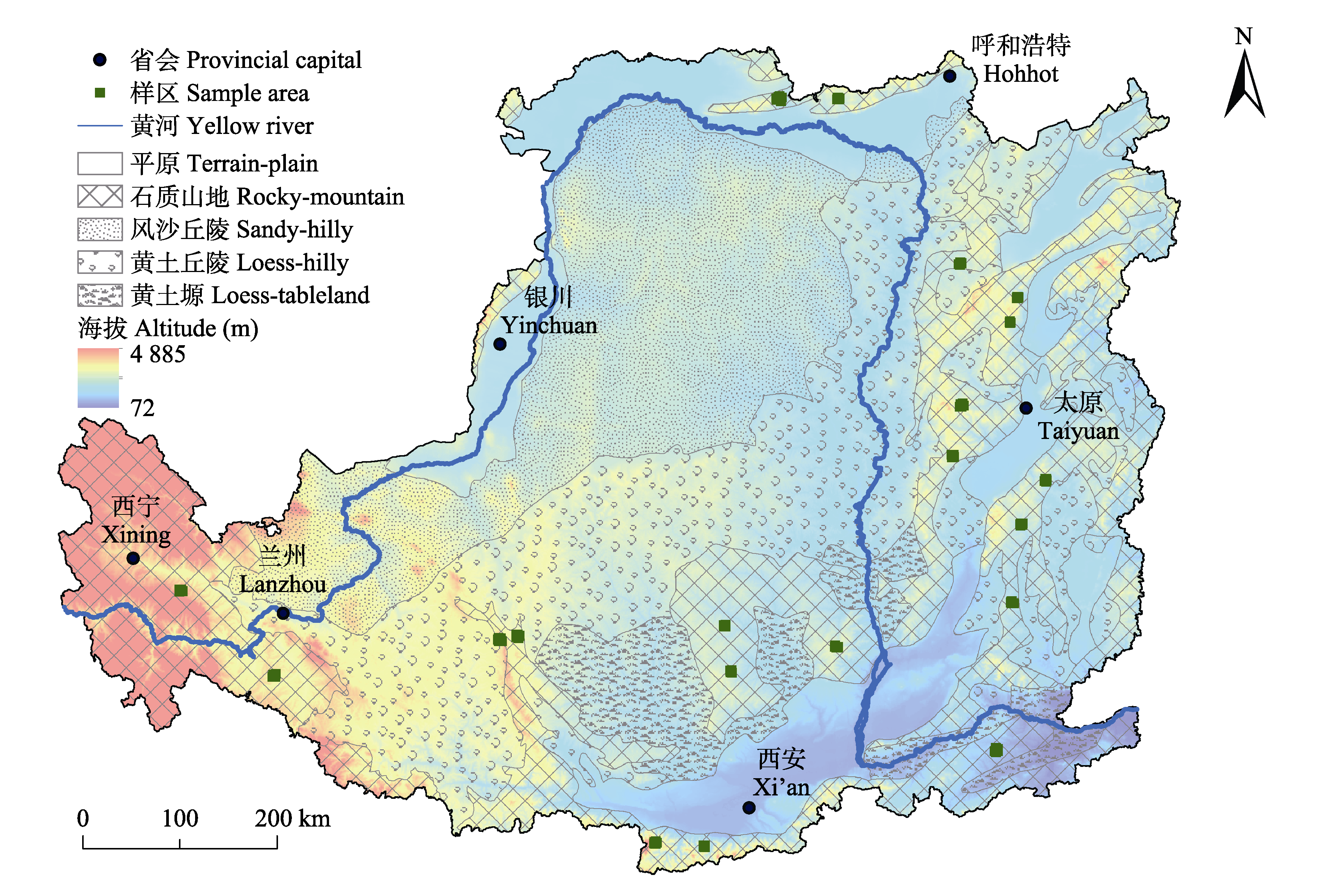
图1 黄土高原地理位置及分区概况。
Fig. 1 Geographical location and zoning overview of the Loess Plateau.
| Slope (VFCO) | 驱动要素 Driven factor | 划分标准 Standard | 贡献率估算依据 Contribution margin estimation basis | ||
|---|---|---|---|---|---|
| Slope (VFCC) | Slope (VFCH) | 气候变化 Climate changes (C) | 人类活动 Human activities (H) | ||
| >0 (改善 Improvement) | C & H | >0 | >0 | ||
| C | >0 | <0 | 100 | 0 | |
| H | <0 | >0 | 0 | 100 | |
| <0 (抑制 Inhibition) | C & H | <0 | <0 | ||
| C | <0 | >0 | 100 | 0 | |
| H | >0 | <0 | 0 | 100 | |
表1 植被盖度(VFC)变化的驱动因素判定及贡献率估算依据
Table 1 Criteria to determine driving factors of the vegetation fractional coverage (VFC) change and estimation of their contribution
| Slope (VFCO) | 驱动要素 Driven factor | 划分标准 Standard | 贡献率估算依据 Contribution margin estimation basis | ||
|---|---|---|---|---|---|
| Slope (VFCC) | Slope (VFCH) | 气候变化 Climate changes (C) | 人类活动 Human activities (H) | ||
| >0 (改善 Improvement) | C & H | >0 | >0 | ||
| C | >0 | <0 | 100 | 0 | |
| H | <0 | >0 | 0 | 100 | |
| <0 (抑制 Inhibition) | C & H | <0 | <0 | ||
| C | <0 | >0 | 100 | 0 | |
| H | >0 | <0 | 0 | 100 | |
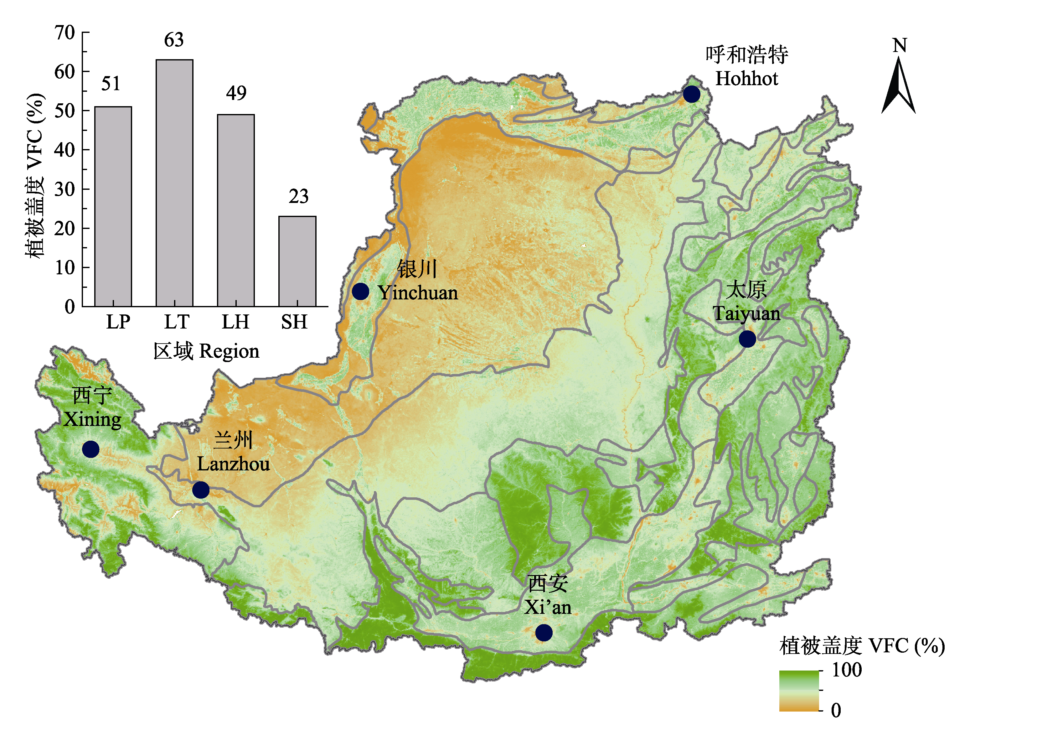
图2 黄土高原20年平均植被盖度分布及其分区植被盖度。LH, 黄土丘陵; LP, 黄土高原; LT, 黄土塬; SH, 风沙丘陵。
Fig. 2 Distribution of 20-year average vegetation fractional coverage (VFC) on the Loess Plateau and its zoning VFC. LH, loess-hilly; LP, Loess Plateau; LT, loess-tableland; SH, sandy-hilly.
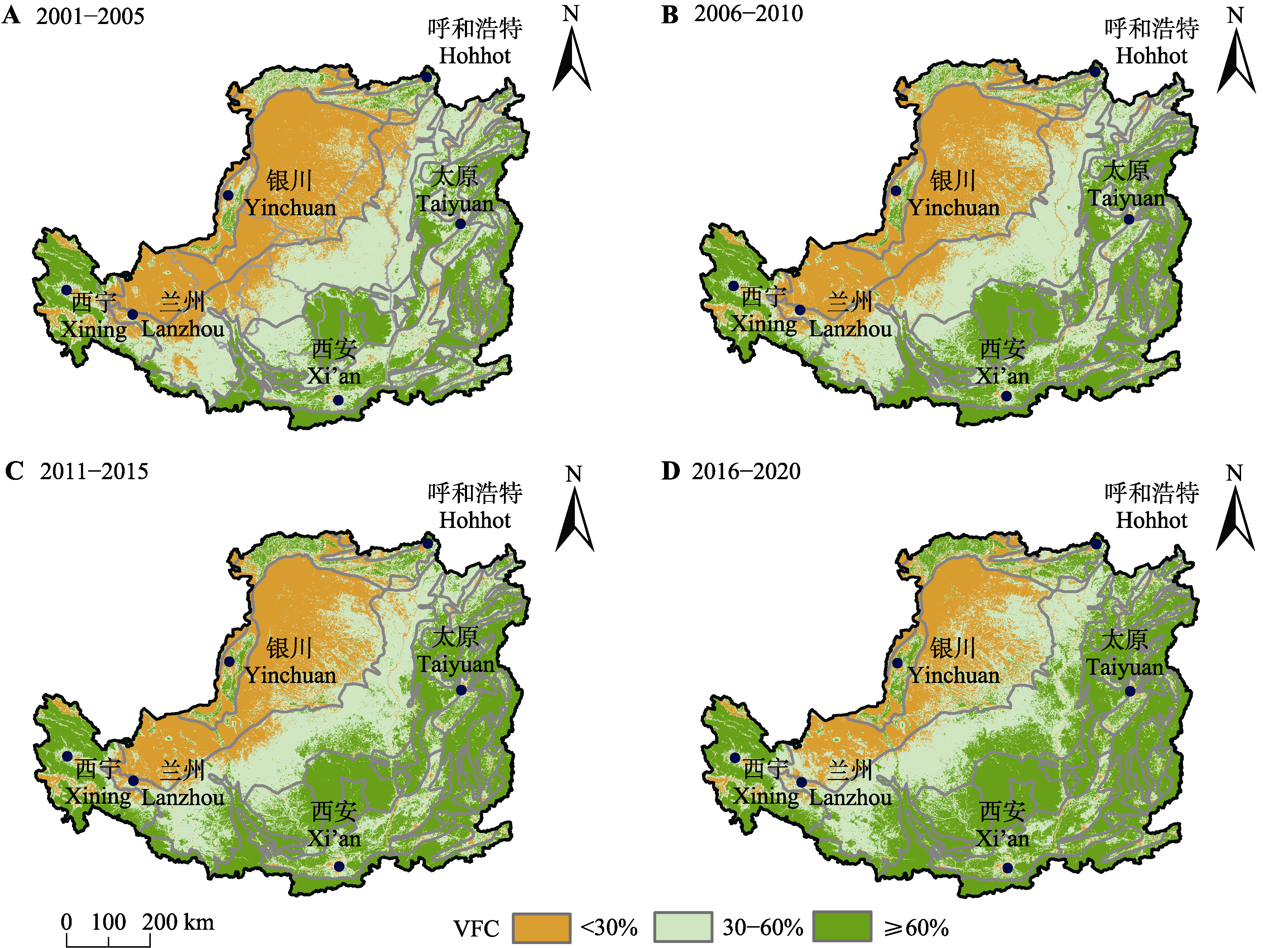
图3 2001-2020年四个时段黄土高原植被盖度(VFC)等级的空间分布变化。
Fig. 3 Changes in spatial distribution of vegetation fractional coverage (VFC) levels in the Loess Plateau in the four stages from 2001 to 2020.
| 区域 Region | 年份 Year | VFC (%) | 不同覆盖度等级面积所占比例 Proportion of areas with different coverage levels (%) | ||
|---|---|---|---|---|---|
| I (<30%) | II (30%-60%) | III (≥60%) | |||
| 黄土高原 Loess Plateau | 2001-2005 | 44 | 31 | 41 | 28 |
| 2006-2010 | 48 | 27 | 38 | 35 | |
| 2011-2015 | 53 | 23 | 36 | 41 | |
| 2016-2020 | 57 | 17 | 34 | 49 | |
| 黄土塬 Loess-tableland | 2001-2005 | 54 | 2 | 68 | 30 |
| 2006-2010 | 62 | 1 | 42 | 56 | |
| 2011-2015 | 65 | 2 | 33 | 66 | |
| 2016-2020 | 69 | 1 | 20 | 79 | |
| 黄土丘陵 Loess-hilly | 2001-2005 | 40 | 22 | 68 | 10 |
| 2006-2010 | 45 | 16 | 69 | 15 | |
| 2011-2015 | 52 | 8 | 64 | 29 | |
| 2016-2020 | 58 | 3 | 55 | 42 | |
| 风沙丘陵 Sandy-hilly | 2001-2005 | 17 | 88 | 11 | 1 |
| 2006-2010 | 20 | 82 | 17 | 1 | |
| 2011-2015 | 23 | 75 | 23 | 2 | |
| 2016-2020 | 29 | 58 | 38 | 3 | |
表2 2001-2020年黄土高原及各地貌分区四个时段植被盖度(VFC)等级统计
Table 2 Statistics of vegetation fractional coverage (VFC) levels in the Loess Plateau and various places of landscape from 2001 to 2020
| 区域 Region | 年份 Year | VFC (%) | 不同覆盖度等级面积所占比例 Proportion of areas with different coverage levels (%) | ||
|---|---|---|---|---|---|
| I (<30%) | II (30%-60%) | III (≥60%) | |||
| 黄土高原 Loess Plateau | 2001-2005 | 44 | 31 | 41 | 28 |
| 2006-2010 | 48 | 27 | 38 | 35 | |
| 2011-2015 | 53 | 23 | 36 | 41 | |
| 2016-2020 | 57 | 17 | 34 | 49 | |
| 黄土塬 Loess-tableland | 2001-2005 | 54 | 2 | 68 | 30 |
| 2006-2010 | 62 | 1 | 42 | 56 | |
| 2011-2015 | 65 | 2 | 33 | 66 | |
| 2016-2020 | 69 | 1 | 20 | 79 | |
| 黄土丘陵 Loess-hilly | 2001-2005 | 40 | 22 | 68 | 10 |
| 2006-2010 | 45 | 16 | 69 | 15 | |
| 2011-2015 | 52 | 8 | 64 | 29 | |
| 2016-2020 | 58 | 3 | 55 | 42 | |
| 风沙丘陵 Sandy-hilly | 2001-2005 | 17 | 88 | 11 | 1 |
| 2006-2010 | 20 | 82 | 17 | 1 | |
| 2011-2015 | 23 | 75 | 23 | 2 | |
| 2016-2020 | 29 | 58 | 38 | 3 | |
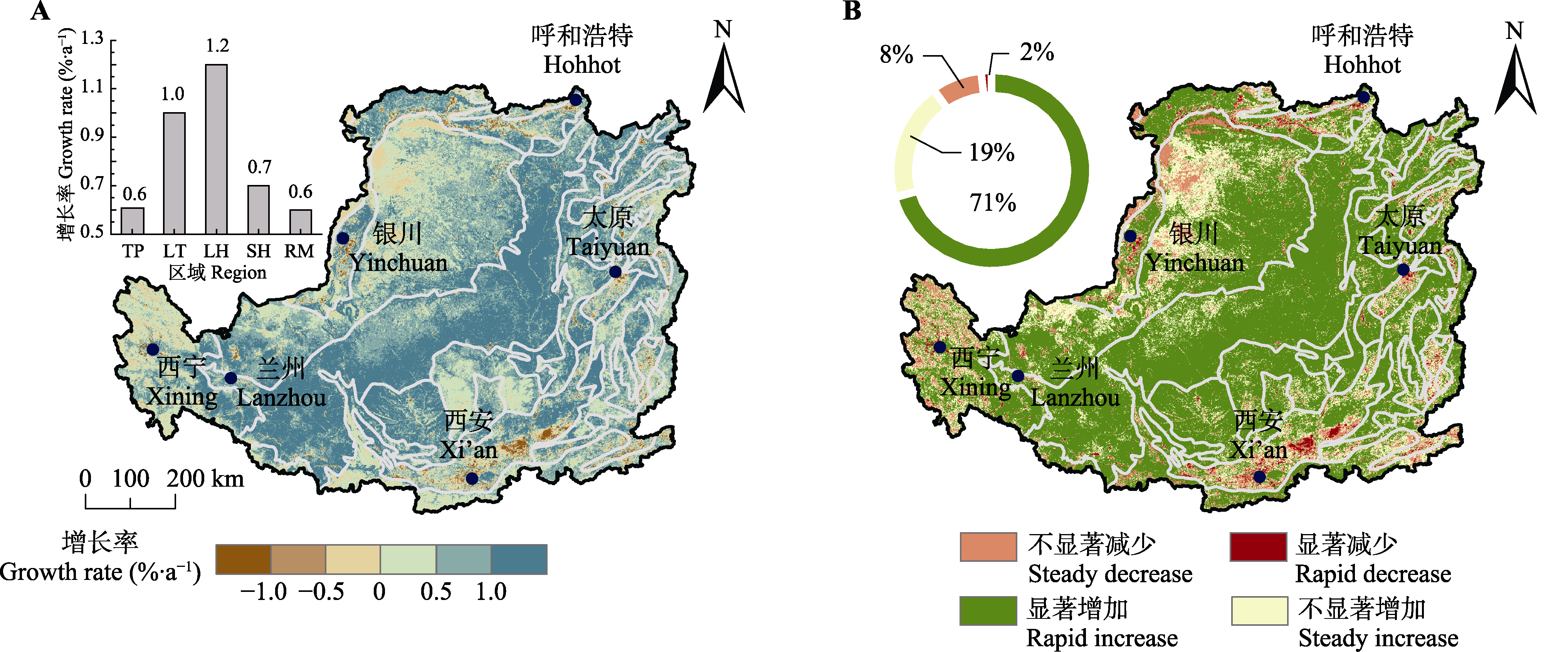
图4 2001-2020年黄土高原植被变化趋势(A)及显著性分布和面积占比(B)。LH, 黄土丘陵; LP, 黄土高原; LT, 黄土塬; RM, 石质山地; SH, 风沙丘陵。
Fig. 4 Distribution of vegetation change trend (A), and significant distribution and area proportion of vegetation change (B) of the Loess Plateau from 2001 to 2020. LH, loess-hilly; LP, Loess Plateau; LT, loess-tableland; RM, rocky-mountain; SH, sandy-hilly.
| 地貌区 Geomorphological area | C (%) | 区内市(省) City (province) in the zones | Slopei (%) | Pi (%) | Ci (%) |
|---|---|---|---|---|---|
| 黄土丘陵 Loess-hilly | 40 | 榆林(陕西) Yulin (Shaanxi) | 1.2 | 17 | 18 |
| 延安(陕西) Yan?an (Shaanxi) | 1.4 | 10 | 11 | ||
| 庆阳(甘肃) Qingyang (Gansu) | 1.2 | 9 | 9 | ||
| 吕梁(山西) Lüliang (Shanxi) | 1.3 | 7 | 8 | ||
| 定西(甘肃) Dingxi (Gansu) | 1.3 | 6 | 7 | ||
| 固原(宁夏) Guyuan (Ningxia) | 1.6 | 5 | 6 | ||
| 天水(甘肃) Tianshui (Gansu) | 1.3 | 5 | 6 | ||
| 风沙丘陵 Sandy-hilly | 23 | 鄂尔多斯(内蒙古) Ordos (Nei Mongol) | 0.5 | 57 | 45 |
| 榆林(陕西) Yulin (Shaanxi) | 1.1 | 11 | 17 | ||
| 白银(甘肃) Baiyin (Gansu) | 0.8 | 11 | 13 | ||
| 吴忠(宁夏) Wuzhong (Ningxia) | 0.8 | 7 | 9 | ||
| 兰州(甘肃) Lanzhou (Gansu) | 0.9 | 6 | 8 | ||
| 石质山区 Rocky-mountain | 18 | 忻州(山西) Xinzhou (Shanxi) | 0.8 | 8 | 9 |
| 延安(陕西) Yan?an (Shaanxi) | 0.6 | 8 | 8 | ||
| 临汾(山西) Linfen (Shanxi) | 0.9 | 4 | 6 | ||
| 黄土塬 Loess-tableland | 8 | 庆阳(甘肃) Qingyang (Gansu) | 1.1 | 23 | 26 |
| 平凉(甘肃) Pingliang (Gansu) | 1.3 | 11 | 15 | ||
| 延安(陕西) Yan?an (Shaanxi) | 0.9 | 14 | 14 | ||
| 咸阳(陕西) Xianyang (Shaanxi) | 1.0 | 13 | 13 | ||
| 临汾(山西) Linfen (Shanxi) | 1.2 | 9 | 11 |
表3 黄土高原地貌区植被变化影响力主要来源分区统计
Table 3 Zoning statistics of the main sources of vegetation changes in the Loess Plateau geomorphological areas
| 地貌区 Geomorphological area | C (%) | 区内市(省) City (province) in the zones | Slopei (%) | Pi (%) | Ci (%) |
|---|---|---|---|---|---|
| 黄土丘陵 Loess-hilly | 40 | 榆林(陕西) Yulin (Shaanxi) | 1.2 | 17 | 18 |
| 延安(陕西) Yan?an (Shaanxi) | 1.4 | 10 | 11 | ||
| 庆阳(甘肃) Qingyang (Gansu) | 1.2 | 9 | 9 | ||
| 吕梁(山西) Lüliang (Shanxi) | 1.3 | 7 | 8 | ||
| 定西(甘肃) Dingxi (Gansu) | 1.3 | 6 | 7 | ||
| 固原(宁夏) Guyuan (Ningxia) | 1.6 | 5 | 6 | ||
| 天水(甘肃) Tianshui (Gansu) | 1.3 | 5 | 6 | ||
| 风沙丘陵 Sandy-hilly | 23 | 鄂尔多斯(内蒙古) Ordos (Nei Mongol) | 0.5 | 57 | 45 |
| 榆林(陕西) Yulin (Shaanxi) | 1.1 | 11 | 17 | ||
| 白银(甘肃) Baiyin (Gansu) | 0.8 | 11 | 13 | ||
| 吴忠(宁夏) Wuzhong (Ningxia) | 0.8 | 7 | 9 | ||
| 兰州(甘肃) Lanzhou (Gansu) | 0.9 | 6 | 8 | ||
| 石质山区 Rocky-mountain | 18 | 忻州(山西) Xinzhou (Shanxi) | 0.8 | 8 | 9 |
| 延安(陕西) Yan?an (Shaanxi) | 0.6 | 8 | 8 | ||
| 临汾(山西) Linfen (Shanxi) | 0.9 | 4 | 6 | ||
| 黄土塬 Loess-tableland | 8 | 庆阳(甘肃) Qingyang (Gansu) | 1.1 | 23 | 26 |
| 平凉(甘肃) Pingliang (Gansu) | 1.3 | 11 | 15 | ||
| 延安(陕西) Yan?an (Shaanxi) | 0.9 | 14 | 14 | ||
| 咸阳(陕西) Xianyang (Shaanxi) | 1.0 | 13 | 13 | ||
| 临汾(山西) Linfen (Shanxi) | 1.2 | 9 | 11 |
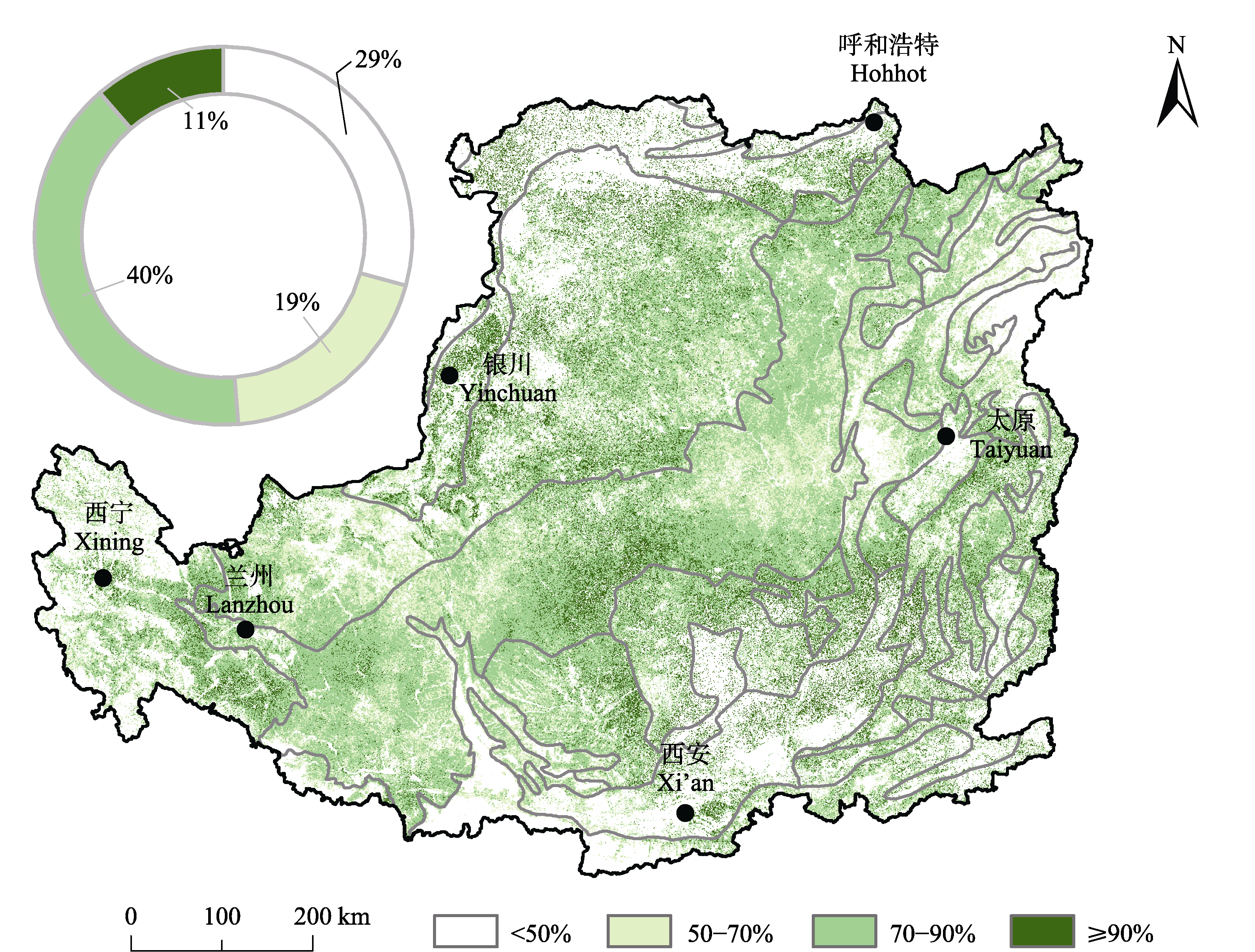
图5 2001-2020年人类活动对黄土高原植被盖度增加贡献率的分布和面积占比。
Fig. 5 Distribution and area proportion of the contribution rate of raising Loess Plateau vegetation fractional coverage from 2001 to 2020.
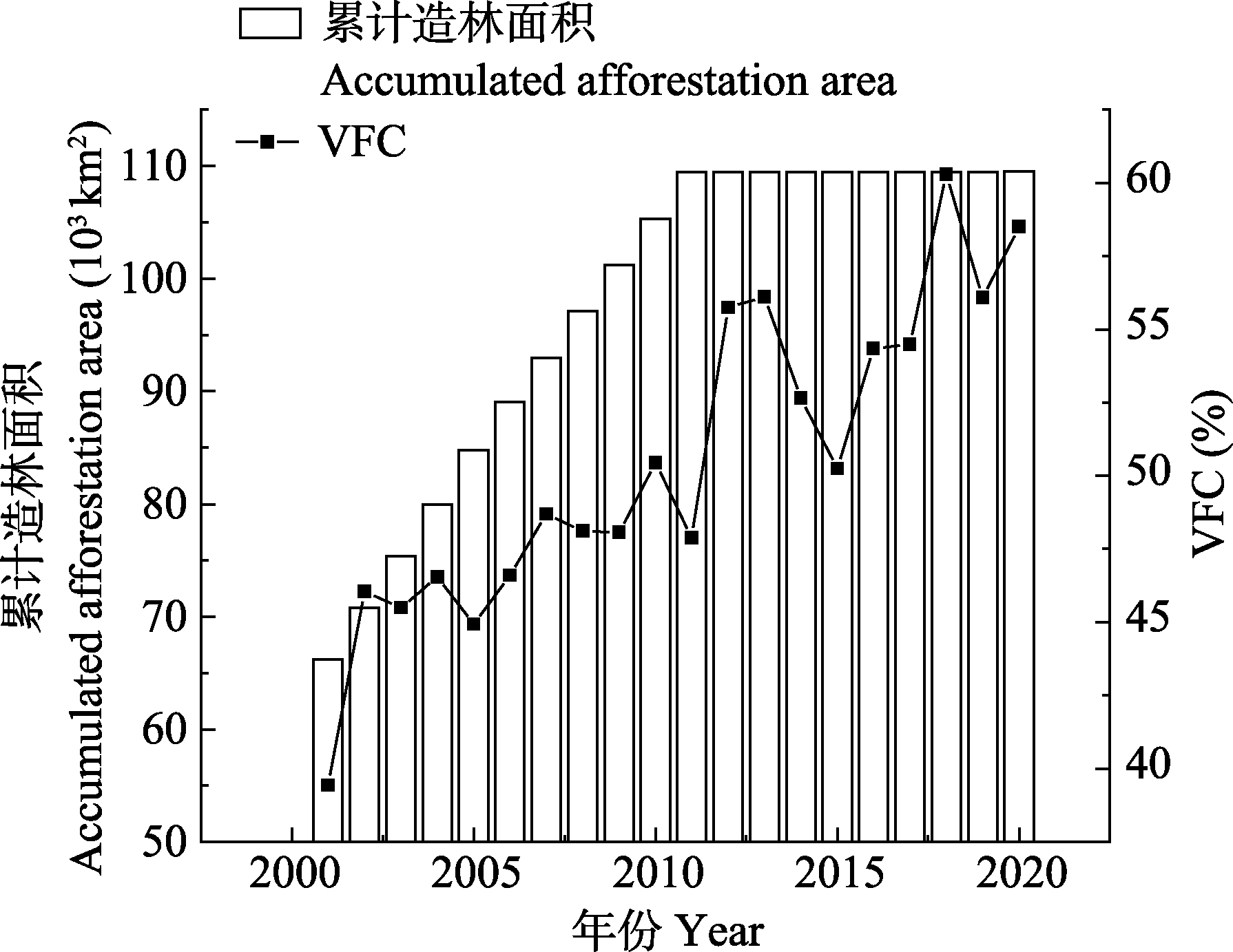
图6 黄土高原累计造林种草面积与年平均植被盖度(VFC)变化。
Fig. 6 Correlation of accumulated afforestation area with vegetation fractional coverage (VFC) change in the Loess Plateau.
| [1] | Cai BF, Yu R (2009). Advance and evaluation in the long time series vegetation trends research based on remote sensing. Journal of Remote Sensing, 13, 1170-1186. |
| [蔡博峰, 于嵘 (2009). 基于遥感的植被长时序趋势特征研究进展及评价. 遥感学报, 13, 1170-1186.] | |
| [2] | Chen N, Li TB, Zhang XP, Chou SR, Xie ML, Liu EJ (2013). Spatiotemporal variations of vegetation coverage in Beiluo River watershed based on remote sensing data analysis. Bulletin of Soil and Water Conservation, 33, 206-210. |
| [陈妮, 李谭宝, 张晓萍, 丑述仁, 谢名礼, 刘二佳 (2013). 北洛河流域植被覆盖度时空变化的遥感动态分析. 水土保持通报, 33, 206-210.] | |
| [3] |
Daughtry CST (2001). Discriminating crop residues from soil by shortwave infrared reflectance. Agronomy Journal, 93, 125-131.
DOI URL |
| [4] | Dong Y, Yin DQ, Li Y, Yan TL, Wang HS (2020). Spatio- temporal patterns of vegetation change and driving forces in the Loess Plateau. Journal of China Agricultural University, 25(8), 120-131. |
| [董镱, 尹冬勤, 李渊, 严泰来, 王红说 (2020). 黄土高原植被的时空变化及其驱动力分析研究. 中国农业大学学报, 25(8), 120-131.] | |
| [5] |
Evans J, Geerken R (2004). Discrimination between climate and human-induced dryland degradation. Journal of Arid Environments, 57, 535-554.
DOI URL |
| [6] |
Feng Q, Zhao W, Ding J, Fang X, Zhang X (2018). Estimation of the cover and management factor based on stratified coverage and remote sensing indices: a case study in the Loess Plateau of China. Journal of Soils and Sediments, 18, 775-790.
DOI URL |
| [7] |
Guan K, Wood EF, Caylor KK (2012). Multi-sensor derivation of regional vegetation fractional cover in Africa. Remote Sensing of Environment, 124, 653-665.
DOI URL |
| [8] |
Guerschman JP, Hill MJ, Renzullo LJ, Barrett DJ, Marks AS, Botha EJ (2009). Estimating fractional cover of photosynthetic vegetation, non-photosynthetic vegetation and bare soil in the Australian tropical savanna region upscaling the EO-1 Hyperion and MODIS sensors. Remote Sensing of Environment, 113, 928-945.
DOI URL |
| [9] |
Guerschman JP, Scarth PF, McVicar TR, Renzullo LJ, Malthus TJ, Stewart JB, Rickards JE, Trevithick R (2015). Assessing the effects of site heterogeneity and soil properties when unmixing photosynthetic vegetation, non-photosynthetic vegetation and bare soil fractions from Landsat and MODIS data. Remote Sensing of Environment, 161, 12-26.
DOI URL |
| [10] | Guo MJ, Zhang TT, Zhang JJ, Chen LL, Zhang XP (2014). Response of vegetation coverage to climate change in the Loess Plateau in 1982-2006. Research of Soil and Water Conservation, 21(5), 35-40. |
| [郭敏杰, 张亭亭, 张建军, 陈利利, 张晓萍 (2014). 1982-2006年黄土高原地区植被覆盖度对气候变化的响应. 水土保持研究, 21(5), 35-40.] | |
| [11] | Guo YQ, Wang NJ, Chu XS, Li C, Luo XQ, Feng H (2019). Analyzing vegetation coverage changes and its reasons on the Loess Plateau based on Google Earth Engine. China Environmental Science, 39, 4804-4811. |
| [郭永强, 王乃江, 褚晓升, 李成, 罗晓琦, 冯浩 (2019). 基于Google Earth Engine分析黄土高原植被覆盖变化及原因. 中国环境科学, 39, 4804-4811.] | |
| [12] | He L, Lyu D, Guo JW, Lei SY, He J, Zhang XP, Yang XH (2020). Study on vegetation coverage change of Beiluo River Basin based on MODIS. Yellow River, 42(2), 67-71. |
| [何亮, 吕渡, 郭晋伟, 雷斯越, 贺洁, 张晓萍, 杨希华 (2020). 基于MODIS的北洛河流域植被盖度变化研究. 人民黄河, 42(2), 67-71.] | |
| [13] |
Hill MJ, Guerschman JP (2020). The MODIS global vegetation fractional cover product 2001-2018: characteristics of vegetation fractional cover in grasslands and savanna woodlands. Remote Sensing, 12, 406. DOI: 10.3390/rs12030406.
DOI |
| [14] |
Hirsch RM, Slack JR, Smith RA (1982). Techniques of trend analysis for monthly water quality data. Water Resources Research, 18, 107-121.
DOI URL |
| [15] | Huang BW (1955). Lessons learned from the development of a soil erosion zoning map for the Middle Yellow River Basin. Chinese Science Bulletin, (12), 15-21. |
| [黄秉维 (1955). 编制黄河中游流域土壤侵蚀分区图的经验教训. 科学通报, (12), 15-21.] | |
| [16] |
Ji YH, Zhou GS, Wang SD, Wang LX, Zhou MZ (2021). Evolution characteristics and its driving forces analysis of vegetation ecological quality in Qinling Mountains region from 2000 to 2019. Chinese Journal of Plant Ecology, 45, 617-625.
DOI URL |
| [汲玉河, 周广胜, 王树东, 王丽霞, 周梦子 (2021). 2000-2019年秦岭地区植被生态质量演变特征及驱动力分析. 植物生态学报, 45, 617-625.] | |
| [17] |
Jin K, Wang F, Han JQ, Shi SY, Ding WB (2020). Contribution of climatic change and human activities to vegetation NDVI change over China during 1982-2015. Acta Geographica Sinica, 75, 961-974.
DOI |
|
[金凯, 王飞, 韩剑桥, 史尚渝, 丁文斌 (2020). 1982-2015年中国气候变化和人类活动对植被NDVI变化的影响. 地理学报, 75, 961-974.]
DOI |
|
| [18] | Jing K (1985). Approach to the erosion zonalization of the Loess Plateau. Mountain Research, 3(3), 161-165. |
| [景可 (1985). 黄土高原侵蚀分区探讨. 山地研究, 3(3), 161-165.] | |
| [19] | Kendall MG (1990). Rank Correlation Measures. 4th ed. Charles Griffin, London. |
| [20] |
Kim Y, Yang Z, Cohen WB, Pflugmacher D, Lauver CL, Vankat JL (2009). Distinguishing between live and dead standing tree biomass on the North Rim of Grand Canyon National Park, USA using small-footprint lidar data. Remote Sensing of Environment, 113, 2499-2510.
DOI URL |
| [21] | Li T, Lü YH, Ren YJ, Li PF (2020). Gauging the effectiveness of vegetation restoration and the influence factors in the Loess Plateau. Acta Ecologica Sinica, 40, 8593-8605. |
| [李婷, 吕一河, 任艳姣, 李朋飞 (2020). 黄土高原植被恢复成效及影响因素. 生态学报, 40, 8593-8605.] | |
| [22] | Liu B, Zhang K, Yun X (2002). An empirical soil loss equation //Proceedings 12th International Soil Conservation Organization Conference: Process of Soil Erosion and Its Environment Effect II. Qinghua University Press, Beijing. 21-25. |
| [23] | Liu MX, Zhao RD, Shao P, Jiao J, Li LR, Che YD (2018). Temporal and spatial variation of vegetation coverage and its driving forces in the Loess Plateau from 2001 to 2015. Arid Land Geography, 41, 99-108. |
| [刘旻霞, 赵瑞东, 邵鹏, 焦骄, 李俐蓉, 车应弟 (2018). 近15 a黄土高原植被覆盖时空变化及驱动力分析. 干旱区地理, 41, 99-108.] | |
| [24] | Liu XQ, Zhao JB, Yu XF (2006). Study on the climatic warming-drying trend in the Loess Plateau and the countermeasures. Arid Zone Research, 23, 627-631. |
| [刘晓清, 赵景波, 于学峰 (2006). 黄土高原气候暖干化趋势及适应对策. 干旱区研究, 23, 627-631.] | |
| [25] | Liu XY, Gao YF, Yang ST, Luo Y (2016). The Causes of the Sharp Decrease in Water and Sand in the Yellow River in Recent Years. Science Press, Beijing. |
| [刘晓燕, 高云飞, 杨胜天, 罗娅 (2016). 黄河近年水沙锐减成因. 科学出版社, 北京.] | |
| [26] | Ma F, Zhuo J, He HJ, Han SS (2020). Ecological evolution and driving mechanism of vegetation in Yulin City, Shaanxi Province. Bulletin of Soil and Water Conservation, 40(5), 257-261. |
| [马锋, 卓静, 何慧娟, 韩姗姗 (2020). 陕西省榆林市植被生态演变及其驱动机制. 水土保持通报, 40(5), 257-261.] | |
| [27] |
Ma QM, Long YP, Jia XP, Wang HB, Li YS (2019). Vegetation response to climatic variation and human activities on the Ordos Plateau from 2000 to 2016. Environmental Earth Sciences, 78, 701-709.
DOI |
| [28] |
Mann HB (1945). Nonparametric tests against trend. Econometrica, 13, 245-259.
DOI URL |
| [29] | National Bureau of Statistics (2020). China Statistical Yearbook (County-Level)-2020. China Statistics Press, Beijing. |
| [国家统计局 (2020). 中国县域统计年鉴(县市卷)-2020. 中国统计出版社, 北京.] | |
| [30] | National Forestry and Grassland Administration (2019). China Forestry and Grassland Statistical Yearbook. China Forestry Publishing House, Beijing. |
| [国家林业和草原局 (2019). 中国林业和草原统计年鉴. 中国林业出版社, 北京.] | |
| [31] |
Newnham GJ, Verbesselt J, Grant IF, Anderson SAJ (2011). Relative Greenness Index for assessing curing of grassland fuel. Remote Sensing of Environment, 115, 1456-1463.
DOI URL |
| [32] |
Ouyang D, Yuan N, Sheu L, Lau G, Chen C, Lai CJ (2013). Community health education at student-run clinics leads to sustained improvement in patientsʼ hepatitis B knowledge. Journal of Community Health, 38, 471-479.
DOI PMID |
| [33] |
Schimel DS (1995). Terrestrial biogeochemical cycles: global estimates with remote sensing. Remote Sensing of Environment, 51, 49-56.
DOI URL |
| [34] |
Sen PK (1968). Estimates of the regression coefficient based on Kendallʼs tau. Journal of the American Statistical Association, 63, 1379-1389.
DOI URL |
| [35] |
Shi H, Shao MA (2000). Soil and water loss from the Loess Plateau in China. Journal of Arid Environments, 45, 9-20.
DOI URL |
| [36] | Sun R, Chen SH, Su HB (2019). Spatiotemporal variations of NDVl of different land cover types on the Loess Plateau from 2000 to 2016. Progress in Geography, 38, 1248-1258. |
|
[孙锐, 陈少辉, 苏红波 (2019). 2000-2016年黄土高原不同土地覆盖类型植被NDVI时空变化. 地理科学进展, 38, 1248-1258.]
DOI |
|
| [37] | Sun WY, Song XY, Mu XM, Gao P, Wang F, Zhao GJ (2015). Spatiotemporal vegetation cover variations associated with climate change and ecological restoration in the Loess Plateau. Agricultural and Forest Meteorology, 209- 210, 87-99. |
| [38] | The Integrated Scientific Research Team of Loess Plateau of Chinese Academy of Sciences (2001). Socio-economic Dataset on the Loess Plateau Regionʼs Resources and Environment. China Economy Publishing House, Beijing. |
| [中国科学院黄土高原综合科学考察队 (1992). 黄土高原地区资源环境社会经济数据集. 中国经济出版社, 北京.] | |
| [39] |
Tian ZH, Ren ZG, Wei HT (2021). Driving mechanism of the spatiotemporal evolution of vegetation in the Yellow River Basin from 2000 to 2020. Environmental Science, 43, 743-751.
DOI URL |
| [田智慧, 任祖光, 魏海涛 (2021). 2000-2020 年黄河流域植被时空演化驱动机制. 环境科学, 43, 743-751.] | |
| [40] |
Tucker CJ, Slayback DA, Pinzon JE, Los SO, Myneni RB, Taylor MG (2001). Higher northern latitude normalized difference vegetation index and growing season trends from 1982 to 1999. International Journal of Biometeorology, 45(4), 184-190.
PMID |
| [41] |
Wang J, Xie YW, Wang XY, Guo KM (2020). Driving factors of recent vegetation changes in Hexi region, northwest China based on a new classification framework. Remote Sensing, 12, 1758. DOI: 10.3390/rs12111758.
DOI |
| [42] | Wang JF, He L, Lu SJ, Lü D, Huang T, Cao Q, Zhang XP, Liu BY (2020). Photosynthetic vegetation cover response to precipitation on the Inner Mongolian Steppe. Acta Ecologica Sinica, 40, 5620-5629. |
| [王举凤, 何亮, 陆绍娟, 吕渡, 黄涛, 曹琦, 张晓萍, 刘宝元 (2020). 内蒙古不同类型草原光合植被覆盖度对降水变化的响应. 生态学报, 40, 5620-5629.] | |
| [43] |
Wessels KJ, Prince SD, Malherbe J, Small J, Frost PE, VanZyl D (2007). Can human-induced land degradation be distinguished from the effects of rainfall variability? A case study in South Africa. Journal of Arid Environments, 68, 271-297.
DOI URL |
| [44] | Wischmeier WH, Smith DD (1978). Predicting Rainfall Erosion Losses—A Guide to Conservation Planning. U.S. Department of Agriculture, Washington D.C. |
| [45] | Xin ZB, Xu JX, Zheng W (2007). Contribution of climate change and human activities on vegetation cover change on the Loess Plateau. Scientia Sinica (Terrae), 37, 1504-1514. |
| [信忠保, 许炯心, 郑伟 (2007). 气候变化和人类活动对黄土高原植被覆盖变化的影响. 中国科学(地球科学), 37, 1504-1514.] | |
| [46] | Yan R, Zhang XP, Yan SJ, Zhao WH (2016). Topographical distribution characteristics of vegetation restoration in the Beiluo River Basin from 1995 to 2014. Journal of Northeastern University (Natural Science), 37, 1598-1603. |
|
[闫瑞, 张晓萍, 闫胜军, 赵文慧 (2016). 1995-2014 年北洛河流域植被恢复的地形分布特征. 东北大学学报(自然科学版), 37, 1598-1603.]
DOI |
|
| [47] | Yang QK, Song GQ, Li R (1992). Approaches to land resurces surveying of Loess Plateau. Research of Soil and Water Conservation, (2), 13-25. |
| [杨勤科, 宋桂琴, 李锐 (1992). 黄土高原土地资源调查中几个问题的讨论. 水土保持研究, (2), 13-25.] | |
| [48] | Yang WZ, Tian JL (2004). Essential exploration of soil aridization in Loess Plateau. Acta Pedologica Sinica, 41, 1-6. |
| [杨文治, 田均良 (2004). 黄土高原土壤干燥化问题探源. 土壤学报, 41, 1-6.] | |
| [49] |
Yang XH, Zhang XP, Lv D, Yin SQ, Zhang MX, Zhu QGZ, Yu Q, Liu BY (2020). Remote sensing estimation of the soil erosion cover-management factor for Chinaʼs Loess Plateau. Land Degradation & Development, 31, 1942-1955.
DOI URL |
| [50] | Yi L, Ren ZY, Zhang C, Liu W (2014). Vegetation cover, climate and human activities on the Loess Plateau. Resources Science, 36, 166-174. |
| [易浪, 任志远, 张翀, 刘雯 (2014). 黄土高原植被覆盖变化与气候和人类活动的关系. 资源科学, 36, 166-174.] | |
| [51] | Zhang LY, Li X, Feng JH, Rao RG, He TY, Chen Y (2021). Spatial-temporal changes of NDVl in Yellow River Basin and its dual response to climate change and human activities during 2000-2018. Bulletin of Soil and Water Conservation, 41(5), 276-286. |
| [张乐艺, 李霞, 冯京辉, 饶日光, 何天英, 陈瑜 (2021). 2000-2018年黄河流域NDVI时空变化及其对气候和人类活动的双重响应. 水土保持通报, 41(5), 276-286.] | |
| [52] | Zhang SL, Yu YM (1994). Methodology for Calculating the Benefits of Water and Soil Conservation for Water and Sand Reduction. China Environmental Press, Beijing. |
| [张胜利, 于一鸣 (1994). 水土保持减水减沙效益计算方法. 中国环境科学出版社, 北京.] | |
| [53] | Zhang Y, Liu BY, Shi PJ, Jiang ZS (2001). Crop cover factor estimating for soil loss prediction. Acta Ecologica Sinica, 21, 1050-1056. |
| [张岩, 刘宝元, 史培军, 江忠善 (2001). 黄土高原土壤侵蚀作物覆盖因子计算. 生态学报, 21, 1050-1056.] | |
| [54] | Zhao AZ, Liu XF, Zhu XF, Pan YZ, Chen SC (2016). Spatiotemporal analyses and associated driving forces of vegetation coverage change in the Loess Plateau. China Environmental Science, 36, 1568-1578. |
| [赵安周, 刘宪锋, 朱秀芳, 潘耀忠, 陈抒晨 (2016). 2000-2014 年黄土高原植被覆盖时空变化特征及其归因. 中国环境科学, 36, 1568-1578.] | |
| [55] | Zhu XM (1991). The formation of Loess Plateau and its harnessing measures. Bulletin of Soil and Water Conservation, 11(1), 1-8. |
| [朱显谟 (1991). 黄土高原的形成与整治对策. 水土保持通报, 11(1), 1-8.] |
| [1] | 陈以恒 玉素甫江·如素力 阿卜杜热合曼·吾斯曼. 2001-2020年天山新疆段草地植被覆盖度时空变化及驱动因素分析[J]. 植物生态学报, 2024, 48(5): 561-576. |
| [2] | 杨宇萌, 来全, 刘心怡. 气候变化和人类活动对内蒙古植被总初级生产力的定量影响[J]. 植物生态学报, 2024, 48(3): 306-316. |
| [3] | 吴瀚, 白洁, 李均力, 古丽•加帕尔, 包安明. 新疆地区植被覆盖度时空变化及其影响因素分析[J]. 植物生态学报, 2024, 48(1): 41-55. |
| [4] | 张雪, 韩凤朋, 肖波, 沈思铭. 黄土高原生物结皮对地表粗糙度和灌草植物种子二次扩散的影响[J]. 植物生态学报, 2023, 47(12): 1668-1683. |
| [5] | 姜玉峰, 李晶, 信瑞瑞, 李艺. 沿海养殖池塘对红树林生态系统影响的时空变化监测与分析[J]. 植物生态学报, 2022, 46(10): 1268-1279. |
| [6] | 薛金儒, 吕肖良. 黄土高原生态工程实施下基于日光诱导叶绿素荧光的植被恢复生产力效益评价[J]. 植物生态学报, 2022, 46(10): 1289-1304. |
| [7] | 杨克彤, 常海龙, 陈国鹏, 俞筱押, 鲜骏仁. 兰州市主要绿化植物气孔性状特征[J]. 植物生态学报, 2021, 45(2): 187-196. |
| [8] | 李媛媛, 张芸, 孔昭宸, 杨振京. 新疆阿尔泰红山嘴地区的表土孢粉与现代植被[J]. 植物生态学报, 2021, 45(2): 174-186. |
| [9] | 乔鲜果, 郭柯, 赵利清, 王孜, 刘长成. 中国长芒草群系的群落特征[J]. 植物生态学报, 2020, 44(9): 986-994. |
| [10] | 张文强, 罗格平, 郑宏伟, 王浩, HAMDI Rafiq, 何惠丽, 蔡鹏, 陈春波. 基于随机森林模型的内陆干旱区植被指数变化与驱动力分析: 以北天山北坡中段为例[J]. 植物生态学报, 2020, 44(11): 1113-1126. |
| [11] | 史娜娜, 肖能文, 王琦, 韩煜, 高晓奇, 冯瑾, 全占军. 锡林郭勒植被NDVI时空变化及其驱动力定量分析[J]. 植物生态学报, 2019, 43(4): 331-341. |
| [12] | 汪星, 宫兆宁, 井然, 张磊, 金点点. 基于连续统去除法的水生植物提取及其时空变化分析——以官厅水库库区为例[J]. 植物生态学报, 2018, 42(6): 640-652. |
| [13] | 李单凤, 于顺利, 王国勋, 方伟伟. 黄土高原优势灌丛营养器官化学计量特征的环境分异和机制[J]. 植物生态学报, 2015, 39(5): 453-465. |
| [14] | 荐圣淇, 赵传燕, 方书敏, 余凯, 马文瑛. 黄土高原丘陵沟壑区柠条与沙棘冠层的持水能力[J]. 植物生态学报, 2013, 37(1): 45-51. |
| [15] | 吴见, 刘民士, 李伟涛. 不同地形条件下植被盖度信息提取技术研究[J]. 植物生态学报, 2013, 37(1): 18-25. |
| 阅读次数 | ||||||
|
全文 |
|
|||||
|
摘要 |
|
|||||
Copyright © 2022 版权所有 《植物生态学报》编辑部
地址: 北京香山南辛村20号, 邮编: 100093
Tel.: 010-62836134, 62836138; Fax: 010-82599431; E-mail: apes@ibcas.ac.cn, cjpe@ibcas.ac.cn
备案号: 京ICP备16067583号-19