
植物生态学报 ›› 2024, Vol. 48 ›› Issue (10): 1274-1290.DOI: 10.17521/cjpe.2023.0300 cstr: 32100.14.cjpe.2023.0300
所属专题: 全球变化与生态系统; 生态系统碳水能量通量; 碳储量
张智洋, 赵颖慧, 甄贞*( )
)
收稿日期:2023-10-20
接受日期:2024-03-06
出版日期:2024-10-20
发布日期:2024-12-03
通讯作者:
甄贞
基金资助:
ZHANG Zhi-Yang, ZHAO Ying-Hui, ZHEN Zhen*()
Received:2023-10-20
Accepted:2024-03-06
Online:2024-10-20
Published:2024-12-03
Contact:
ZHEN Zhen
Supported by:摘要: 流域尺度的土地利用/土地覆盖变化(LUCC)动态监测和陆地生态系统碳储量估测, 可以为土地利用优化、提高陆地生态系统碳储量、实现“双碳”目标提供建议。该研究基于1986-2022年Landsat 5 TM和Landsat 8 OLI影像, 应用随机森林获取松花江流域1986-2022年10期高精度的土地利用分布图, 并结合生态系统服务综合价值评估利权衡(InVEST)模型、Mann-Kendall检验和Theil-Sen Median趋势分析, 对松花江流域36年间土地利用类型和生态系统碳储量变化进行动态监测。结果发现, 流域内各土地利用类型面积由大到小依次为耕地>有林地>草地>未利用地>水域>建设用地>疏林地>灌木林地, 耕地、有林地和草地为研究区主要土地利用类型。1986-2022年间耕地面积增加11 462.68 km2, 有林地面积减少18 567.21 km2。建设用地为研究区变化最快地类, 变化率为5.3%, 面积增加3 505.82 km2。疏林地变化率为4.7%, 仅次于建设用地, 但由于其面积变化较小, 对流域影响不大。未利用地变化速率为4.5%, 其面积增加了5 385.43 km2。流域内陆地生态系统碳储量空间分布存在明显的空间异质性, 碳储量高值区分布在大小兴安岭和长白山脉; 中值区分布在兴安盟、松嫩平原和三江平原; 低值区分布在大庆和白城。36年间该流域内陆地生态系统碳储量整体呈现减少趋势, 减少区域主要分布在碳储量高值区, 碳储量增加区域则是零星分布。1994、2002和2018年松花江流域生态系统碳储量出现3次恢复, 且均与有林地面积变化有关。在保障已有林地面积不再减少的基础上, 增加有林地面积, 持续开展林业工程, 可以有效阻止碳储量下降, 恢复研究区生态系统碳储量。
张智洋, 赵颖慧, 甄贞. 基于LUCC的1986-2022年松花江流域陆地生态系统碳储量动态监测. 植物生态学报, 2024, 48(10): 1274-1290. DOI: 10.17521/cjpe.2023.0300
ZHANG Zhi-Yang, ZHAO Ying-Hui, ZHEN Zhen. Dynamic monitoring of carbon storage of the terrestrial ecosystem in Songhua River Basin from 1986 to 2022 based on land use and land cover change. Chinese Journal of Plant Ecology, 2024, 48(10): 1274-1290. DOI: 10.17521/cjpe.2023.0300

图1 松花江流域位置及主要水系图。
Fig. 1 Location and main rivers of the Songhua River Basin.
| 年份 Year | 陆地卫星 Landsat | 传感器 Sensor | 空间分辨率 Spatial resolution (m) | 影像数量 Number of images |
|---|---|---|---|---|
| 1986, 1990, 1994, 1998, 2002, 2006, 2010 | Landsat 5 | TM | 30 | 6 274 |
| 2014, 2018, 2022 | Landsat 8 | OLI | 30 | 3 132 |
表1 1986-2022年松花江流域Landsat系列影像信息
Table 1 Information of Landsat series images applied in Songhua River Basin from 1986 to 2022
| 年份 Year | 陆地卫星 Landsat | 传感器 Sensor | 空间分辨率 Spatial resolution (m) | 影像数量 Number of images |
|---|---|---|---|---|
| 1986, 1990, 1994, 1998, 2002, 2006, 2010 | Landsat 5 | TM | 30 | 6 274 |
| 2014, 2018, 2022 | Landsat 8 | OLI | 30 | 3 132 |
| 分类系统 Classification system | 面积 占比 Proportion of area (%) | 样本 数量 Number of samples | 根据目视解译调 整后样本数 Adjusted sample according to visual interpretation |
|---|---|---|---|
| 耕地 Farmland | 38.9 | 1 945 | 2 165 |
| 有林地 Forest land | 37.5 | 1 875 | 1 833 |
| 草地 Grassland | 9.2 | 460 | 375 |
| 水域 Water | 1.8 | 90 | 122 |
| 建设用地 Construction land | 2.5 | 125 | 130 |
| 未利用地 Unused land | 6.5 | 325 | 205 |
| 灌木林地 Shrub land | 1.7 | 85 | 70 |
| 疏林地 Sparse forest land | 1.9 | 95 | 100 |
| 总计 Sum | 100 | 5 000 | 5 000 |
表2 1986-2022年松花江流域分类系统及样本点数量
Table 2 Classification system and number of samples of different classes in Songhua River Basin from 1986 to 2022
| 分类系统 Classification system | 面积 占比 Proportion of area (%) | 样本 数量 Number of samples | 根据目视解译调 整后样本数 Adjusted sample according to visual interpretation |
|---|---|---|---|
| 耕地 Farmland | 38.9 | 1 945 | 2 165 |
| 有林地 Forest land | 37.5 | 1 875 | 1 833 |
| 草地 Grassland | 9.2 | 460 | 375 |
| 水域 Water | 1.8 | 90 | 122 |
| 建设用地 Construction land | 2.5 | 125 | 130 |
| 未利用地 Unused land | 6.5 | 325 | 205 |
| 灌木林地 Shrub land | 1.7 | 85 | 70 |
| 疏林地 Sparse forest land | 1.9 | 95 | 100 |
| 总计 Sum | 100 | 5 000 | 5 000 |
| 特征(个数) Feature (number) | Landsat 5 TM | 特征(个数) Feature (number) | Landsat 8 OLI |
|---|---|---|---|
| 原始波段 Original band (6) | Bi (i = 1, 2, 3, 4, 5, 7) | 原始波段 Original band (7) | Bi (i = 1, 2, 3, 4, 5, 6, 7) |
| 波段组合 Band combination (6) | B24, B345, B53, B547, B74, VIS234 | 波段组合 Band combination (10) | Albedo, B4/Albedo, B24, B74, B76, B547, B65, B345, B53, VIS234 |
| 植被指数 Vegetation index (16) | ARVI, DVI, EVI, LSWI, MSAVI, MSR, MVI5, MVI7, NDVI, NDWI, NLI, PVI, RDVI, RVI, SAVI, SLAVI | 植被指数 Vegetation index (18) | NDVI, RDVI, NLI, MVI7, MVI5, SLAVI, MSR, PVI, MSAVI, ARVI, SAVI, ND563, EVI, RVI, DVI, NDWI, NDBI, LSWI |
| 纹理特征 Texture feature (102) | Bi_asm, Bi_contrast, Bi_corr, Bi_dent, Bi_diss, Bi_dvar, Bi_ent, Bi_idm, Bi_imcorr1, Bi_imcorr2, Bi_inertia, Bi_prom, Bi_savg, Bi_sent, Bi_shade, Bi_svar, Bi_var | 纹理特征 Texture feature (119) | Bi_asm, Bi_contrast, Bi_corr, Bi_dent, Bi_diss, Bi_dvar, Bi_ent, Bi_idm, Bi_imcorr1, Bi_imcorr2, Bi_inertia, Bi_prom, Bi_savg, Bi_sent, Bi_shade, Bi_svar, Bi_var |
表3 1986-2022年松花江流域提取的Landsat卫星影像特征
Table 3 Extracted features of Landsat images in Songhua River Basin from 1986 to 2022
| 特征(个数) Feature (number) | Landsat 5 TM | 特征(个数) Feature (number) | Landsat 8 OLI |
|---|---|---|---|
| 原始波段 Original band (6) | Bi (i = 1, 2, 3, 4, 5, 7) | 原始波段 Original band (7) | Bi (i = 1, 2, 3, 4, 5, 6, 7) |
| 波段组合 Band combination (6) | B24, B345, B53, B547, B74, VIS234 | 波段组合 Band combination (10) | Albedo, B4/Albedo, B24, B74, B76, B547, B65, B345, B53, VIS234 |
| 植被指数 Vegetation index (16) | ARVI, DVI, EVI, LSWI, MSAVI, MSR, MVI5, MVI7, NDVI, NDWI, NLI, PVI, RDVI, RVI, SAVI, SLAVI | 植被指数 Vegetation index (18) | NDVI, RDVI, NLI, MVI7, MVI5, SLAVI, MSR, PVI, MSAVI, ARVI, SAVI, ND563, EVI, RVI, DVI, NDWI, NDBI, LSWI |
| 纹理特征 Texture feature (102) | Bi_asm, Bi_contrast, Bi_corr, Bi_dent, Bi_diss, Bi_dvar, Bi_ent, Bi_idm, Bi_imcorr1, Bi_imcorr2, Bi_inertia, Bi_prom, Bi_savg, Bi_sent, Bi_shade, Bi_svar, Bi_var | 纹理特征 Texture feature (119) | Bi_asm, Bi_contrast, Bi_corr, Bi_dent, Bi_diss, Bi_dvar, Bi_ent, Bi_idm, Bi_imcorr1, Bi_imcorr2, Bi_inertia, Bi_prom, Bi_savg, Bi_sent, Bi_shade, Bi_svar, Bi_var |
| 土地利用 类型 Land use type | 地上生物 碳密度 Above-ground carbon density | 地下生物 碳密度 Underground carbon density | 土壤碳密度 Soil carbon density | 死亡有机质 碳密度 Dead organic matter carbon density |
|---|---|---|---|---|
| 耕地 Farmland | 7.32 (17.0) | 34.73 (80.7) | 101.87 (108.4) | 4.23 (9.82) |
| 有林地 Forest land | 18.24 (42.4) | 49.87 (115.9) | 149.24 (158.8) | 6.07 (14.11) |
| 草地 Grassland | 15.19 (35.3) | 37.22 (86.5) | 93.89 (99.9) | 3.13 (7.28) |
| 水域 Water | 0.13 (0.3) | 0 (0) | 0 (0) | 0 (0) |
| 建设用地 Construction land | 1.08 (2.5) | 11.83 (27.5) | 0 (0) | 0 (0) |
| 未利用地 Unused land | 0.56 (1.30) | 0 (0) | 20.30 (21.60) | 0 (0) |
| 灌木林地 Shrub land | 3.42 | 1.62 | 91.70 | 3.48 |
| 疏林地 Sparse forest land | 5.47 (12.72) | 14.96 (34.77) | 149.24 (158.80) | 6.07 (14.11) |
表4 松花江流域不同土地利用类型的碳密度修正值(t∙hm-2)
Table 4 Modified carbon densities of different land use types in Songhua River Basin (t∙hm-2)
| 土地利用 类型 Land use type | 地上生物 碳密度 Above-ground carbon density | 地下生物 碳密度 Underground carbon density | 土壤碳密度 Soil carbon density | 死亡有机质 碳密度 Dead organic matter carbon density |
|---|---|---|---|---|
| 耕地 Farmland | 7.32 (17.0) | 34.73 (80.7) | 101.87 (108.4) | 4.23 (9.82) |
| 有林地 Forest land | 18.24 (42.4) | 49.87 (115.9) | 149.24 (158.8) | 6.07 (14.11) |
| 草地 Grassland | 15.19 (35.3) | 37.22 (86.5) | 93.89 (99.9) | 3.13 (7.28) |
| 水域 Water | 0.13 (0.3) | 0 (0) | 0 (0) | 0 (0) |
| 建设用地 Construction land | 1.08 (2.5) | 11.83 (27.5) | 0 (0) | 0 (0) |
| 未利用地 Unused land | 0.56 (1.30) | 0 (0) | 20.30 (21.60) | 0 (0) |
| 灌木林地 Shrub land | 3.42 | 1.62 | 91.70 | 3.48 |
| 疏林地 Sparse forest land | 5.47 (12.72) | 14.96 (34.77) | 149.24 (158.80) | 6.07 (14.11) |
| 特征 Feature | Landsat 5 TM (41) | 特征 Feature | Landsat 8 OLI (59) |
|---|---|---|---|
| 原始波段 Original band (6) | Bi (i = 1, 2, 3, 4, 5, 7) | 原始波段 Original band (7) | Bi (i = 1, 2, 3, 4, 5, 6, 7) |
| 波段组合 Band combination (6) | B547, B53, B24, B74, B345, VIS234 | 波段组合 Band combination (11) | B76, B74, ND563, B547, B65, B53, B4/Albedo, B24, VIS234, Albedo, B345 |
| 植被指数 Vegetation index (16) | SLAVI, NDWI, SAVI, MSR, PVI, NLI, ARVI, LSWI, DVI, RDVI, RVI, NDVI, MVI5, MVI7, EVI, MSAVI | 植被指数 Vegetation index (17) | NDBI, SLAVI, NDWI, NDVI, PVI, SAVI, ARVI, MSR, LSWI, NLI, MSAVI, EVI、RVI, RDVI, MVI5, MVI7, DVI |
| 纹理特征 Texture feature (13) | B3_savg, B4_savg, B7_savg, B2_savg, B1_savg, B5_savg, B4_shade, B5_shade, B4_corr, B4_imcorr1, B5_idm, B3_shade, B5_imcorr1 | 纹理特征 Texture feature (24) | B6_savg, B3_savg, B4_savg, B7_savg, B2_savg, B1_savg, B6_shade, B5_savg, B2_shade, B6_asm, B3_shade, B5_idm, B6_idm, B7_shade, B5_corr, B5_sent, B5_imcorr2, B5_var, B4_corr, B5_shade, B1_shade, B3_imcorr1, B3_corr, B5_ent |
表5 1986-2022年松花江流域筛选后分类特征分布
Table 5 After filtrating classification feature distribution in Songhua River Basin from 1986 to 2022
| 特征 Feature | Landsat 5 TM (41) | 特征 Feature | Landsat 8 OLI (59) |
|---|---|---|---|
| 原始波段 Original band (6) | Bi (i = 1, 2, 3, 4, 5, 7) | 原始波段 Original band (7) | Bi (i = 1, 2, 3, 4, 5, 6, 7) |
| 波段组合 Band combination (6) | B547, B53, B24, B74, B345, VIS234 | 波段组合 Band combination (11) | B76, B74, ND563, B547, B65, B53, B4/Albedo, B24, VIS234, Albedo, B345 |
| 植被指数 Vegetation index (16) | SLAVI, NDWI, SAVI, MSR, PVI, NLI, ARVI, LSWI, DVI, RDVI, RVI, NDVI, MVI5, MVI7, EVI, MSAVI | 植被指数 Vegetation index (17) | NDBI, SLAVI, NDWI, NDVI, PVI, SAVI, ARVI, MSR, LSWI, NLI, MSAVI, EVI、RVI, RDVI, MVI5, MVI7, DVI |
| 纹理特征 Texture feature (13) | B3_savg, B4_savg, B7_savg, B2_savg, B1_savg, B5_savg, B4_shade, B5_shade, B4_corr, B4_imcorr1, B5_idm, B3_shade, B5_imcorr1 | 纹理特征 Texture feature (24) | B6_savg, B3_savg, B4_savg, B7_savg, B2_savg, B1_savg, B6_shade, B5_savg, B2_shade, B6_asm, B3_shade, B5_idm, B6_idm, B7_shade, B5_corr, B5_sent, B5_imcorr2, B5_var, B4_corr, B5_shade, B1_shade, B3_imcorr1, B3_corr, B5_ent |
| 分类器 Classifier | 精度 Accuracy (%) | 耕地 Farmland | 有林地 Forest land | 草地 Grassland | 水域 Water | 建设用地 Construction land | 未利用地 Unused land | 灌木林地 Shrubland | 疏林地 Sparse forest land |
|---|---|---|---|---|---|---|---|---|---|
| RF | UA | 96.31 ± 0.80 | 96.44 ± 1.09 | 93.15 ± 1.28 | 97.39 ± 2.00 | 95.37 ± 2.76 | 94.18 ± 1.55 | 100.00 ± 0.00 | 98.68 ± 1.07 |
| PA | 98.54 ± 0.45 | 98.70 ± 0.34 | 87.94 ± 2.30 | 91.82 ± 2.79 | 93.15 ± 2.81 | 85.24 ± 2.13 | 69.82 ± 2.59 | 80.00 ± 1.63 | |
| OA | 96.11 ± 0.51 | ||||||||
| CART | UA | 96.13 ± 0.60 | 96.79 ± 0.72 | 84.40 ± 1.40 | 92.92 ± 2.56 | 92.24 ± 2.57 | 83.64 ± 3.17 | 72.35 ± 5.74 | 73.71 ± 5.68 |
| PA | 96.27 ± 0.62 | 96.44 ± 0.44 | 84.09 ± 2.20 | 90.31 ± 2.37 | 91.41 ± 1.86 | 78.65 ± 1.68 | 80.51 ± 1.16 | 82.04 ± 1.42 | |
| OA | 94.95 ± 0.51 | ||||||||
| SVM | UA | 92.06 ± 1.70 | 92.52 ± 2.44 | 78.60 ± 4.30 | 94.96 ± 2.28 | 94.22 ± 2.40 | 88.73 ± 2.68 | 80.23 ± 6.45 | 78.55 ± 5.41 |
| PA | 95.53 ± 0.91 | 95.75 ± 0.53 | 73.02 ± 6.85 | 86.32 ± 1.11 | 83.02 ± 2.85 | 63.97 ± 3.53 | 59.14 ± 10.38 | 61.30 ± 10.79 | |
| OA | 90.93 ± 1.25 | ||||||||
表6 1986-2022年松花江流域土地利用类型平均分类精度(平均值±标准差)
Table 6 Average classification accuracy in Songhua River Basin from 1986 to 2022 (mean ± SD)
| 分类器 Classifier | 精度 Accuracy (%) | 耕地 Farmland | 有林地 Forest land | 草地 Grassland | 水域 Water | 建设用地 Construction land | 未利用地 Unused land | 灌木林地 Shrubland | 疏林地 Sparse forest land |
|---|---|---|---|---|---|---|---|---|---|
| RF | UA | 96.31 ± 0.80 | 96.44 ± 1.09 | 93.15 ± 1.28 | 97.39 ± 2.00 | 95.37 ± 2.76 | 94.18 ± 1.55 | 100.00 ± 0.00 | 98.68 ± 1.07 |
| PA | 98.54 ± 0.45 | 98.70 ± 0.34 | 87.94 ± 2.30 | 91.82 ± 2.79 | 93.15 ± 2.81 | 85.24 ± 2.13 | 69.82 ± 2.59 | 80.00 ± 1.63 | |
| OA | 96.11 ± 0.51 | ||||||||
| CART | UA | 96.13 ± 0.60 | 96.79 ± 0.72 | 84.40 ± 1.40 | 92.92 ± 2.56 | 92.24 ± 2.57 | 83.64 ± 3.17 | 72.35 ± 5.74 | 73.71 ± 5.68 |
| PA | 96.27 ± 0.62 | 96.44 ± 0.44 | 84.09 ± 2.20 | 90.31 ± 2.37 | 91.41 ± 1.86 | 78.65 ± 1.68 | 80.51 ± 1.16 | 82.04 ± 1.42 | |
| OA | 94.95 ± 0.51 | ||||||||
| SVM | UA | 92.06 ± 1.70 | 92.52 ± 2.44 | 78.60 ± 4.30 | 94.96 ± 2.28 | 94.22 ± 2.40 | 88.73 ± 2.68 | 80.23 ± 6.45 | 78.55 ± 5.41 |
| PA | 95.53 ± 0.91 | 95.75 ± 0.53 | 73.02 ± 6.85 | 86.32 ± 1.11 | 83.02 ± 2.85 | 63.97 ± 3.53 | 59.14 ± 10.38 | 61.30 ± 10.79 | |
| OA | 90.93 ± 1.25 | ||||||||
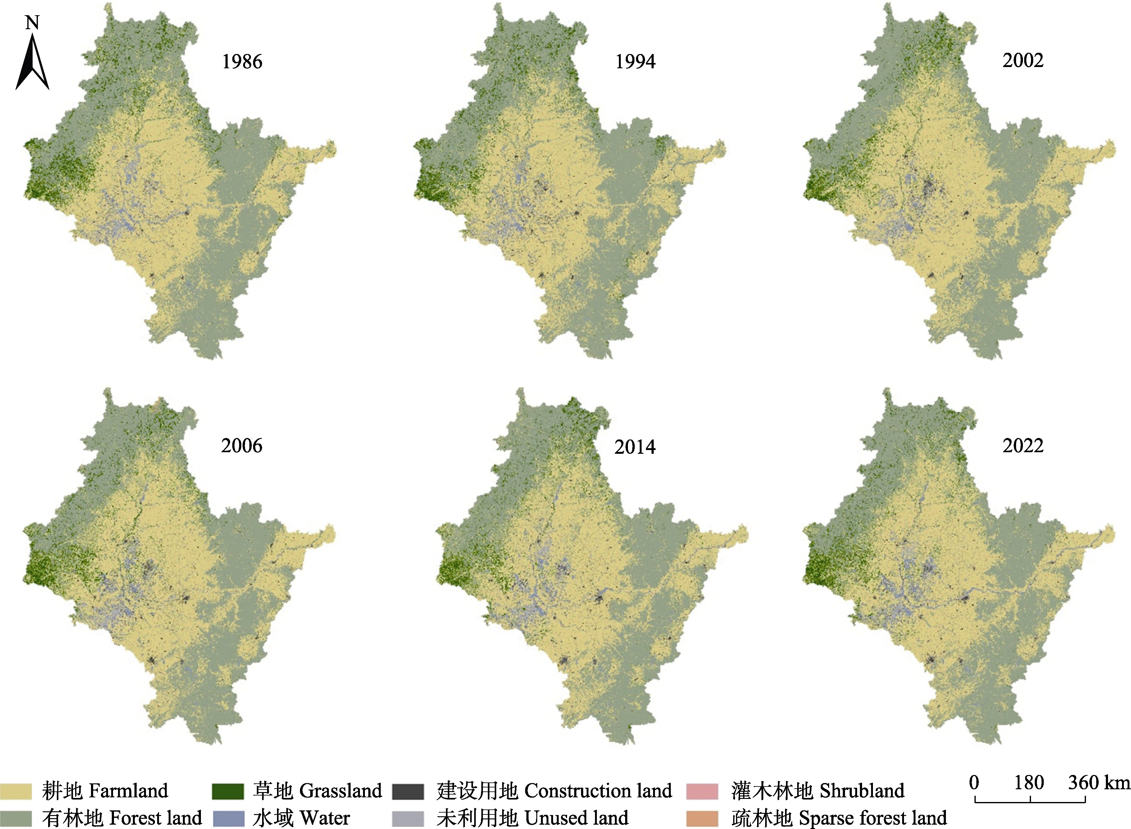
图2 1986-2022年松花江流域土地利用/土地覆盖分布图(以6个年份为例)。
Fig. 2 Land use/cover distribution map of Songhua River Basin from 1986 to 2022 taking six years as examples.
| 面积 Area (km2) | 2022年 Year 2022 | ||||||||
|---|---|---|---|---|---|---|---|---|---|
| 耕地 Farmland | 有林地 Forest land | 草地 Grassland | 水域 Water | 建设用地 Construction land | 未利用地 Unused land | 灌木林地 Shrub land | 疏林地 Sparse forest land | ||
| 1986年 Year 1986 | 耕地 Farmland | 207 453.66 | 13 937.97 | 9 681.31 | 2 551.13 | 5 555.53 | 7 654.9 | 2.48 | 99.93 |
| 有林地 Forest land | 30 620.98 | 196 805.08 | 8 890.87 | 455.72 | 170.39 | 673.10 | 1.80 | 254.39 | |
| 草地 Grassland | 12 618.49 | 7 737.45 | 14 586.81 | 165.69 | 152.94 | 326.89 | 2.86 | 146.23 | |
| 水域 Water | 1 982.64 | 84.02 | 115.34 | 7 485.19 | 454.06 | 2 005.93 | 0.00 | 0.36 | |
| 建设用地 Construction land | 2 104.01 | 53.70 | 141.51 | 404.59 | 2 091.40 | 972.07 | 0.03 | 0.47 | |
| 未利用地 Unused land | 3 500.47 | 420.91 | 515.34 | 967.51 | 847.69 | 4 927.76 | 0.05 | 0.97 | |
| 灌木林地 Shrubland | 14.55 | 9.37 | 17.75 | 0.07 | 0.10 | 0.11 | 0.05 | 0.24 | |
| 疏林地 Sparse forest land | 108.25 | 256.62 | 191.59 | 3.30 | 1.49 | 5.37 | 0.06 | 6.60 | |
表7 1986-2022年松花江流域土地利用类型转移矩阵(km2)
Table 7 Land use/cover change and its changes in Songhua River Basin from 1986 to 2022 (km2)
| 面积 Area (km2) | 2022年 Year 2022 | ||||||||
|---|---|---|---|---|---|---|---|---|---|
| 耕地 Farmland | 有林地 Forest land | 草地 Grassland | 水域 Water | 建设用地 Construction land | 未利用地 Unused land | 灌木林地 Shrub land | 疏林地 Sparse forest land | ||
| 1986年 Year 1986 | 耕地 Farmland | 207 453.66 | 13 937.97 | 9 681.31 | 2 551.13 | 5 555.53 | 7 654.9 | 2.48 | 99.93 |
| 有林地 Forest land | 30 620.98 | 196 805.08 | 8 890.87 | 455.72 | 170.39 | 673.10 | 1.80 | 254.39 | |
| 草地 Grassland | 12 618.49 | 7 737.45 | 14 586.81 | 165.69 | 152.94 | 326.89 | 2.86 | 146.23 | |
| 水域 Water | 1 982.64 | 84.02 | 115.34 | 7 485.19 | 454.06 | 2 005.93 | 0.00 | 0.36 | |
| 建设用地 Construction land | 2 104.01 | 53.70 | 141.51 | 404.59 | 2 091.40 | 972.07 | 0.03 | 0.47 | |
| 未利用地 Unused land | 3 500.47 | 420.91 | 515.34 | 967.51 | 847.69 | 4 927.76 | 0.05 | 0.97 | |
| 灌木林地 Shrubland | 14.55 | 9.37 | 17.75 | 0.07 | 0.10 | 0.11 | 0.05 | 0.24 | |
| 疏林地 Sparse forest land | 108.25 | 256.62 | 191.59 | 3.30 | 1.49 | 5.37 | 0.06 | 6.60 | |
| 土地利用类型 Land use/cover type | 由其他地类转入面积 From other land use into area (km2) | IRLi (%) | 向其他地类转移面积 Transfer area to other land use (km2) | TRLi (%) | 变化面积 Area of change (km2) | CCLi (%) |
|---|---|---|---|---|---|---|
| 耕地 Farmland | 50 949.39 | 0.6 | 39 483.25 | 0.4 | 90 432.64 | 1.0 |
| 有林地 Forest land | 22 500.04 | 0.3 | 41 067.25 | 0.5 | 63 567.29 | 0.8 |
| 草地 Grassland | 19 553.71 | 1.5 | 21 150.55 | 1.6 | 40 704.26 | 3.1 |
| 水域 Water | 4 548.01 | 1.0 | 4 642.35 | 1.1 | 9 190.36 | 2.1 |
| 建设用地 Construction land | 7 182.20 | 3.5 | 3 676.38 | 1.8 | 10 858.58 | 5.3 |
| 未利用地 Unused land | 11 638.37 | 2.9 | 6 252.94 | 1.6 | 17 891.31 | 4.5 |
| 灌木林地 Shrubland | 7.28 | 0.5 | 42.19 | 2.8 | 49.47 | 3.3 |
| 疏林地 Sparse forest land | 502.59 | 2.4 | 465.03 | 2.3 | 967.62 | 4.7 |
表8 1986-2022年松花江流域土地利用/土地覆盖变化及变化速率
Table 8 Land use/cover type change and its change rate in Songhua River Basin from 1986 to 2022
| 土地利用类型 Land use/cover type | 由其他地类转入面积 From other land use into area (km2) | IRLi (%) | 向其他地类转移面积 Transfer area to other land use (km2) | TRLi (%) | 变化面积 Area of change (km2) | CCLi (%) |
|---|---|---|---|---|---|---|
| 耕地 Farmland | 50 949.39 | 0.6 | 39 483.25 | 0.4 | 90 432.64 | 1.0 |
| 有林地 Forest land | 22 500.04 | 0.3 | 41 067.25 | 0.5 | 63 567.29 | 0.8 |
| 草地 Grassland | 19 553.71 | 1.5 | 21 150.55 | 1.6 | 40 704.26 | 3.1 |
| 水域 Water | 4 548.01 | 1.0 | 4 642.35 | 1.1 | 9 190.36 | 2.1 |
| 建设用地 Construction land | 7 182.20 | 3.5 | 3 676.38 | 1.8 | 10 858.58 | 5.3 |
| 未利用地 Unused land | 11 638.37 | 2.9 | 6 252.94 | 1.6 | 17 891.31 | 4.5 |
| 灌木林地 Shrubland | 7.28 | 0.5 | 42.19 | 2.8 | 49.47 | 3.3 |
| 疏林地 Sparse forest land | 502.59 | 2.4 | 465.03 | 2.3 | 967.62 | 4.7 |
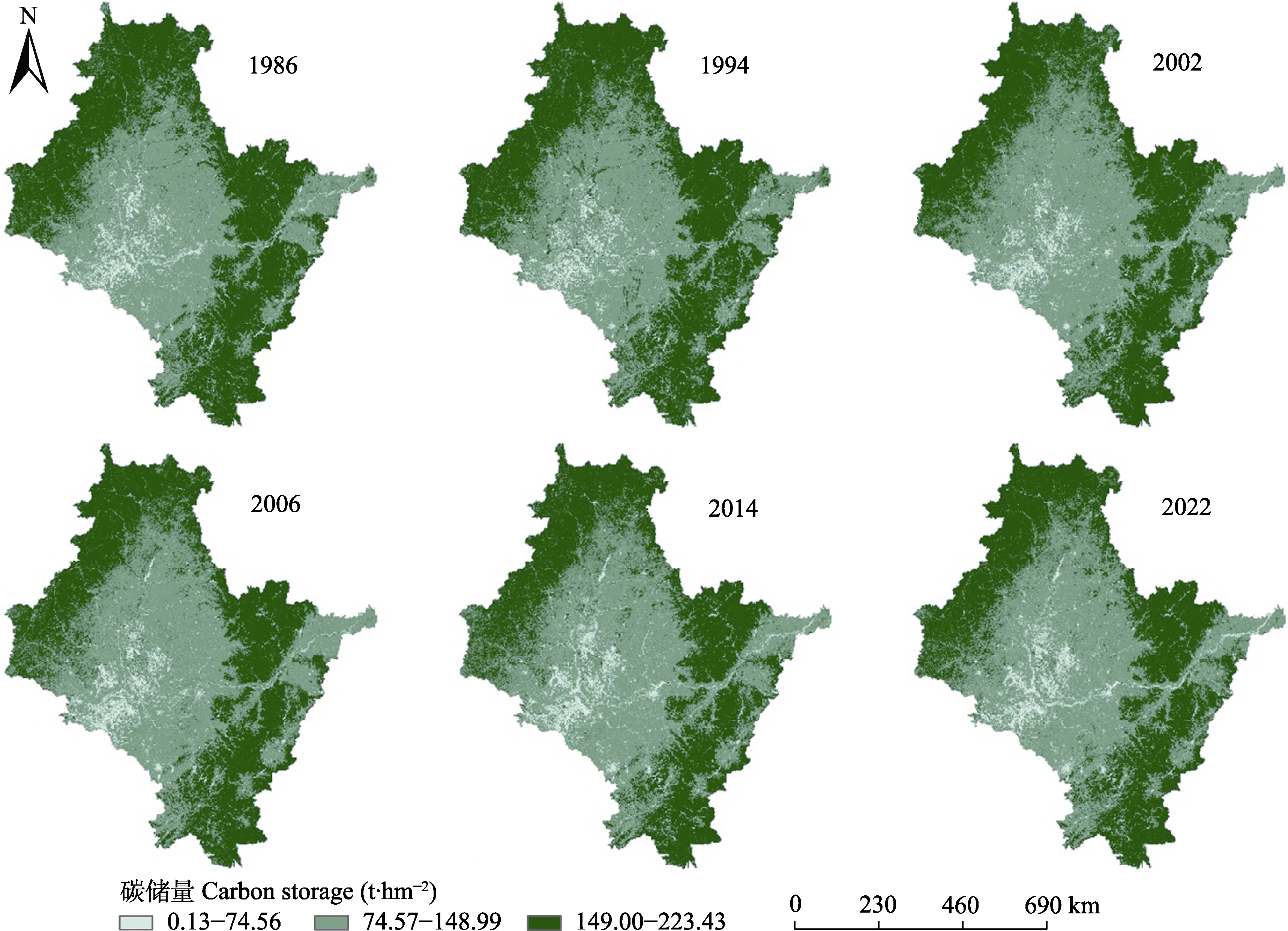
图3 1986-2022年松花江流域碳储量空间分布(以6个年份为例)。
Fig. 3 Spatial distribution of carbon storage in Songhua River Basin from 1986 to 2022 taking six years as examples.
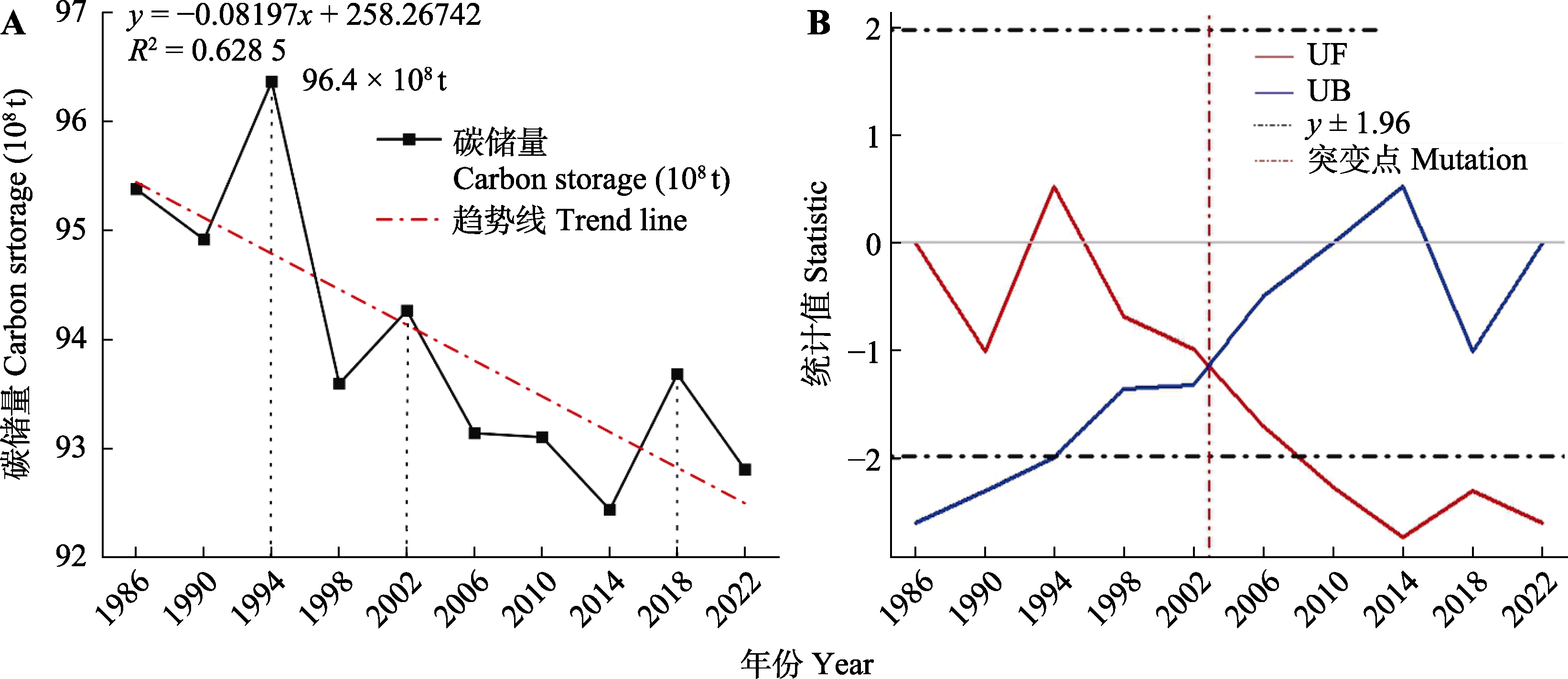
图4 1986-2022年松花江流域碳储量变化趋势。A, 碳储量。B, M-K突变检验。UB, UBk在时间序列k的分布; UF, UFk在时间序列k的分布。
Fig. 4 Map of changes in carbon storage in Songhua River Basin from 1986 to 2022. A, Carbon Storage. B, M-K mutation test. UB is distribution in time series k of UBk; UF is distribution in time series k of UFk.
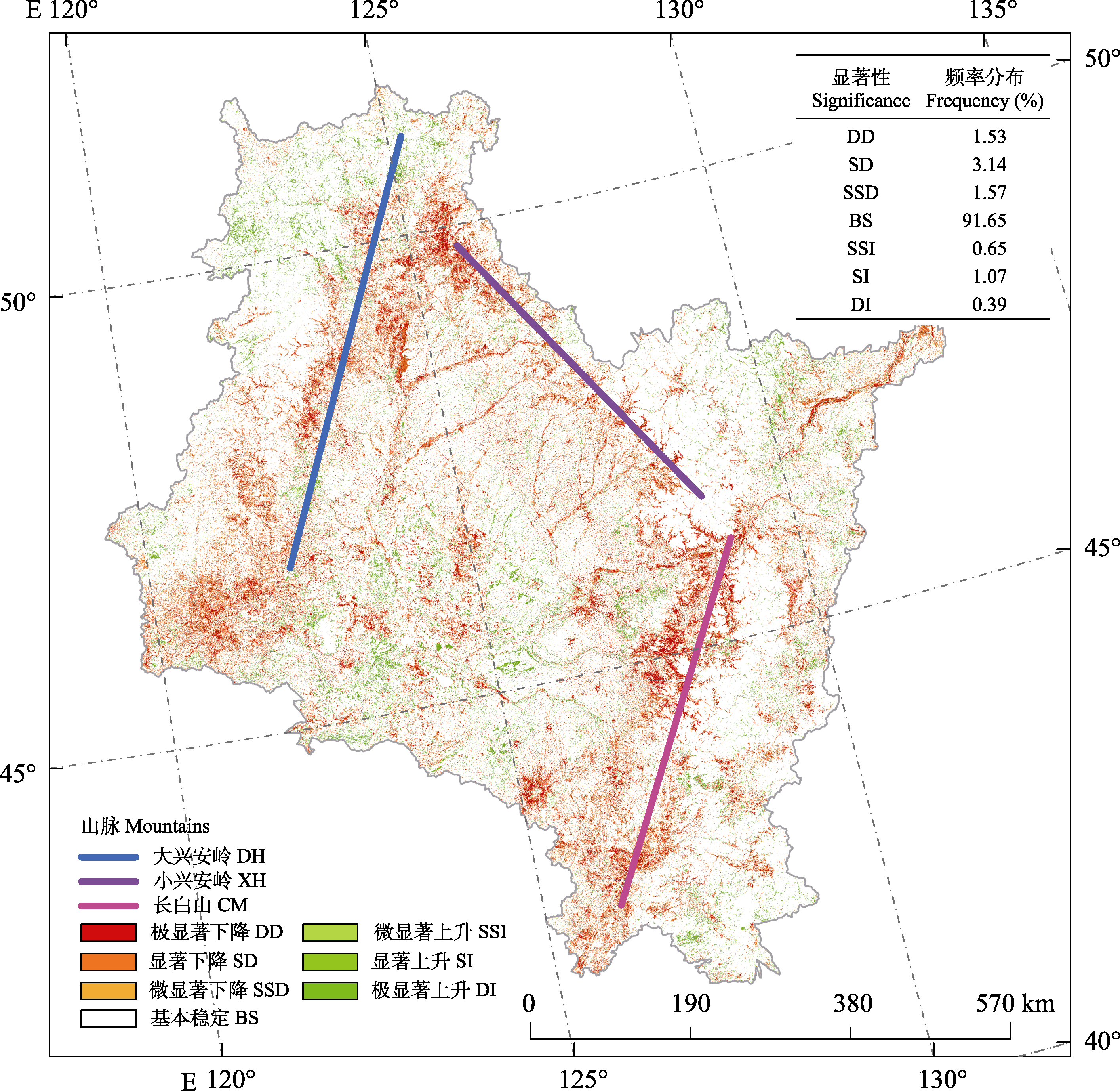
图5 1986-2022年松花江流域碳储量变化趋势显著性分布。
Fig. 5 Significant distribution of carbon storage trends in Songhua River Basin during 1986-2022. CM, Changbai Mountain; DH, Da Hinggan Mountains; XH, Xiao Hinggan Mountains. BS, basically stable; DD, dramatic decline; DI, dramatic increased; SD, significant decline; SI, significant increased; SSD, slight significant decline; SSI, slight significant increased.
| [1] | Alam SA, Starr M, Clark BJF (2013). Tree biomass and soil organic carbon densities across the Sudanese woodland savannah: a regional carbon sequestration study. Journal of Arid Environments, 89, 67-76. |
| [2] | Bao YB, Liu K, Li T, Hu S (2015). Effects of land use change on habitat based on InVEST model—Taking Yellow River Wetland Nature Reserve in Shaanxi Province as an example. Arid Zone Research, 32, 622-629. |
| [ 包玉斌, 刘康, 李婷, 胡胜 (2015). 基于InVEST模型的土地利用变化对生境的影响——以陕西省黄河湿地自然保护区为例. 干旱区研究, 32, 622-629.] | |
| [3] | Cai HJ (2019). The Study on Ecological Function Evaluation and Regionalization of Forest Based on 3S Technology— Taking the Fusong County as an Example. Master degree dissertation, Shenyang Agricultural University, Shenyang. |
| [ 蔡慧君 (2019). 基于3S的森林生态功能评价分区研究——以抚松县为例. 硕士学位论文, 沈阳农业大学, 沈阳.] | |
| [4] | Chen GS, Yang YS, Liu LZ, Li XB, Zhao YC, Yuan YD (2007). Research review on total belowground carbon allocation in forest ecosystems. Journal of Subtropical Resources and Environment, 2(1), 34-42. |
| [ 陈光水, 杨玉盛, 刘乐中, 李熙波, 赵月彩, 袁一丁 (2007). 森林地下碳分配(TBCA)研究进展. 亚热带资源与环境学报, 2(1), 34-42.] | |
| [5] | Chen LC, Tong DC, Qi YF (1995). Discussion on fishery development strategy and measures in Tongjiang City. Northern Chinese Fisheries, (3), 35-36. |
| [ 陈立春, 佟殿纯, 齐永丰 (1995). 同江市渔业发展战略及措施的探讨. 黑龙江水产, (3), 35-36.] | |
| [6] | Chen SS (2016). Evaluation of Ecological Service Function of Water Retention and Soil Conservation in Water Source Area for the South-to-North Water Transfer—A Case Study in Shangluo City. PhD dissertation, Northwest University, Xiʼan. |
| [ 陈姗姗 (2016). 南水北调水源区水源涵养与土壤保持生态系统服务功能研究——以商洛市为例. 博士学位论文, 西北大学, 西安.] | |
| [7] | Cui L (2006). Ecological damage of oil field exploitation and corresponding countermeasures. Heilongjiang Environmental Journal, 30(1), 40-41. |
| [ 崔磊 (2006). 大庆油田开采对生态环境的破坏及应采取的措施. 黑龙江环境通报, 30(1), 40-41.] | |
| [8] | Cui S, Jia ZY, Guo L, Fu Q, Liu D (2024). Impacts of extreme climate events at different altitudinal gradients on vegetation NPP in Songhua River Basin. Environmental Science, 45(1), 275-286. |
| [ 崔嵩, 贾朝阳, 郭亮, 付强, 刘东 (2023). 不同海拔梯度下极端气候事件对松花江流域植被NPP的影响. 环境科学, 45(1), 275-286.] | |
| [9] |
Dai SP, Yi XP, Luo HX, Li HL, Li MF, Zheng Q, Hu YY (2021). Mapping land use in Hainan Island based on Google Earth Engine and Landsat time series data. Chinese Journal of Tropical Crops, 42, 3351-3357.
DOI |
|
[ 戴声佩, 易小平, 罗红霞, 李海亮, 李茂芬, 郑倩, 胡盈盈 (2021). 基于GEE和Landsat时间序列数据的海南岛土地利用分类研究. 热带作物学报, 42, 3351-3357.]
DOI |
|
| [10] | Dai XQ, Shen RQ, Wang J, Wang JY, Zhou JL (2021). Change detection of land use in Henan Province based on GEE remote sensing cloud platform. Journal of Geomatics Science and Technology, 38, 287-294. |
| [ 戴晓琴, 沈瑞淇, 王俊, 汪军阳, 周俊利 (2021). GEE遥感云平台支撑下的河南省土地利用变化检测. 测绘科学技术学报, 38, 287-294.] | |
| [11] | Deng Z, Ding WG, Pu XT, Lyu YJ, Wang YL (2022). Spatial-temporal distribution of carbon storage in Qilian Mountain National Park based on InVEST Model. Bulletin of Soil and Water Conservation, 42(3), 324-334. |
| [ 邓喆, 丁文广, 蒲晓婷, 吕泳洁, 王亚丽 (2022). 基于InVEST模型的祁连山国家公园碳储量时空分布研究. 水土保持通报, 42(3), 324-334.] | |
| [12] | Dong ZY, Wang ZM, Liu DW, Song KS, Li L, Jia MM, Ding Z (2014). Mapping wetland areas using Landsat-derived NDVI and LSWI: a case study of West Songnen Plain, Northeast China. Journal of the Indian Society of Remote Sensing, 42, 569-576. |
| [13] | Du CY, Fan WY, Ma Y, Jin HI, Zhen Z (2021). The effect of synergistic approaches of features and ensemble learning algorith on aboveground biomass estimation of natural secondary forests based on ALS and Landsat 8. Sensors, 21, 5974. DOI: 10.1016/j.ecolind.2021.108490. |
| [14] | Fang KN, Wu JB, Zhu JP, Xie BC (2011). A review of technologies on random forests. Statistics & Information Forum, 26(3), 32-38. |
| [ 方匡南, 吴见彬, 朱建平, 谢邦昌 (2011). 随机森林方法研究综述. 统计与信息论坛, 26(3), 32-38.] | |
| [15] | Fu CB, Tang JX, Dan L, He Y (2016). Temporal and spatial variation of haze pollution over China from 1960 to 2013. Environmental Science, 37, 3237-3248. |
| [ 符传博, 唐家翔, 丹利, 何媛 (2016). 1960-2013年我国霾污染的时空变化. 环境科学, 37, 3237-3248.] | |
| [16] | Fu Q, Xu LL, Zheng HY, Chen JH (2019). Spatiotemporal dynamics of carbon storage in response to urbanization: a case study in the Su-Xi-Chang Region, China. Processes, 7, 836. DOI: 10.3390/pr7110836. |
| [17] | Gao JW, Guo ZM, Liu CQ, Jin WF (1995). On the protection of the natural forest protection project of the Great Xingʼanling, the protection of the Tender River and the Songhua River. Inner Mongolia Forestry Science & Technology, (S1), 36-38. |
| [ 高景文, 郭志敏, 柳长青, 金武范 (1995). 论大兴安岭天然林保护工程对嫩江、松花江的保护作用. 内蒙古林业科技, (S1), 36-38.] | |
| [18] | Giardina CP, Coleman MD, Hancock JE, King JS, Lilleskov EAL, Loya WM, Pregitzer KS, Ryan MG, Trettin CC (2005). The response of belowground carbon allocation in forests to global change//Binkley D, Menyailo O. Tree Species Effects on Soils: Implications for Global Change. Springer, Dordrecht. 119-154. |
| [19] | Han JX, Wang ZM, Mao DH, Song KS, Ren CY (2011). Dynamic change of vegetation coverage in the Songhua River Basin and its correlation analysis with climatic factor from 1982 to 2010. Chinese Journal of Agrometeorology, 32, 430-436. |
| [ 韩佶兴, 王宗明, 毛德华, 宋开山, 任春颖 (2011). 1982-2010年松花江流域植被动态变化及其与气候因子的相关分析. 中国农业气象, 32, 430-436.] | |
| [20] | Haralick RM, Shanmugam K, Dinstein IH (1973). Textural features for image classification. IEEE Transactions on Systems, Man, and Cybernetics, 3, 610-621. |
| [21] | He J, Zhang SF, Li JY (2014). The optimal allocation of agricultural water resources carrying capacity under grain production increases in Songhuajiang. Resources Science, 36, 1780-1788. |
| [ 何杰, 张士锋, 李九一 (2014). 粮食增产背景下松花江区农业水资源承载力优化配置研究. 资源科学, 36, 1780-1788.] | |
| [22] | He LM, Shen ZQ, Kong FS, Liu ZK (2007). Study on multi-source remote sensing images classification with SVM. Journal of Image and Graphics, 12, 648-654. |
| [ 何灵敏, 沈掌泉, 孔繁胜, 刘震科 (2007). SVM在多源遥感图像分类中的应用研究. 中国图象图形学报, 12, 648-654.] | |
| [23] | Hu HQ, Luo BZ, Wei SJ, Wei SW, Wen ZM, Sun L, Luo SS, Wang LM, Ma HB (2015). Estimating biological carbon storage of five typical forest types in the Daxingʼanling Mountains, Heilongjiang, China. Acta Ecologica Sinica, 35, 5745-5760. |
| [ 胡海清, 罗碧珍, 魏书精, 魏书威, 文正敏, 孙龙, 罗斯生, 王立明, 马洪斌 (2015). 大兴安岭5种典型林型森林生物碳储量. 生态学报, 35, 5745-5760.] | |
| [24] | Hu Q, Ma XQ, Hu LT, Wang YJ, Xu L, Pan XB (2019). Application of Matlab in meteorological teaching—M-K test for the abrupt change analysis of meteorological elements. Research and Exploration in Laboratory, 38(12), 48-51. |
| [ 胡琦, 马雪晴, 胡莉婷, 王雅婧, 徐琳, 潘学标 (2019). Matlab在气象专业教学中的应用——气象要素的M-K检验突变分析. 实验室研究与探索, 38(12), 48-51.] | |
| [25] | Jia FF (2014). InVEST Model Based Ecosystem Services Evaluation with Case Study on Ganjiang River Basin. Master degree dissertation, China University of Geosciences, Beijing. |
| [ 贾芳芳 (2014). 基于InVEST模型的赣江流域生态系统服务功能评估. 硕士学位论文, 中国地质大学, 北京.] | |
| [26] | Jiang WG, Deng Y, Tang ZH, Lei X, Chen Z (2017). Modelling the potential impacts of urban ecosystem changes on carbon storage under different scenarios by linking the CLUE-S and the InVEST models. Ecological Modelling, 345, 30-40. |
| [27] | Jin CH, Han JL (2013). Analysis of precipitation variation trend and abrupt change in Gaya River Basin based on Mann-Kendall test. Jilin Water Resources, (12), 62-66. |
| [ 金成浩, 韩京龙 (2013). 基于Mann-Kendall检验的嘎呀河流域降水变化趋势及突变分析. 吉林水利, (12), 62-66.] | |
| [28] | Li FP (2015). Study on Water Cycle and Water Resources in Songhua River Basin Under the Changing Environment. PhD dissertation, University of Chinese Academy of Sciences, Beijing. |
| [ 李峰平 (2015). 变化环境下松花江流域水文与水资源响应研究. 博士学位论文, 中国科学院大学, 北京.] | |
| [29] | Li R (2019). Spatial-temporal Analysis of Land Use Change in Guilin City Based on Google Earth Engine. Master degree dissertation, East China University of Technology, Shanghai. |
| [ 李睿 (2019). 基于Google Earth Engine的桂林市土地利用时空变化分析. 硕士学位论文, 华东理工大学, 上海.] | |
| [30] |
Li XB (1996). A review of the international researches on land use/land cover change. Acta Geographica Sinica, 51, 553-558.
DOI |
|
[ 李秀彬 (1996). 全球环境变化研究的核心领域——土地利用/土地覆被变化的国际研究动向. 地理学报, 51, 553-558.]
DOI |
|
| [31] | Li XX, Huang L, Li K (2021). Analysis of spatio-temporal change of land use around Erhai Lake from 1991 to 2020 based on GEE platform. GNSS World of China, 46(5), 17-25. |
| [ 李小祥, 黄亮, 李凯 (2021). 基于GEE平台的1991-2020年环洱海地带土地利用时空变化分析. 全球定位系统, 46(5), 17-25.] | |
| [32] | Li XY, Huang CS, Jin HJ, Han YL, Kang SQ, Liu J, Cai HY, Hu TX, Yang G, Yu HZ, Sun L (2022). Spatio-temporal patterns of carbon storage derived using the InVEST model in Heilongjiang Province, Northeast China. Frontiers in Earth Science, 10, 846456. DOI: 10.3389/feart.2022.846456. |
| [33] | Liang YJ, Liu LJ, Huang JJ (2017). Integrating the SD-CLUE-S and InVEST models into assessment of oasis carbon storage in northwestern China. PLoS ONE, 12, e0172494. DOI: 10.1371/journal.pone.0172494. |
| [34] | Liu BY (2020). Analysis of Land Use Change and Driving Force in Chenzhou Based on Google Earth Engine. Master degree dissertation, China University of Geosciences, Beijing. |
| [ 刘博远 (2020). 基于Google Earth Engine的郴州市土地利用变化及其驱动力分析. 硕士学位论文, 中国地质大学, 北京.] | |
| [35] | Liu P (2022). Research on Urban Expansion and Driving Forces in the Three Provinces of Northeast China Based on Google Earth Engine. Master degree dissertation, Jilin University, Changchun. |
| [ 刘鹏 (2022). 基于GEE的东北三省城市扩张及驱动力研究. 硕士学位论文, 吉林大学, 长春.] | |
| [36] |
Liu SH, He SJ (2002). A spatial analysis model for measuring the rate of land use change. Journal of Natural Resources, 17, 533-540.
DOI |
| [ 刘盛和, 何书金 (2002). 土地利用动态变化的空间分析测算模型. 自然资源学报, 17, 533-540.] | |
| [37] | Liu ZQ, Li LH, Li XJ, Cao YZ, Li GH (2006). Ecological risk assessment of naphthalene in the soil of a petrochemicals- contaminated site. China Environmental Science, 26, 746-750. |
| [ 刘志全, 李丽和, 李秀金, 曹云者, 李广贺 (2006). 石油化工污染土壤中萘的生态风险评价. 中国环境科学, 26, 746-750.] | |
| [38] | Luo SQ, Hu XM, Sun Y, Yan C, Zhang X (2023). Multi- scenario land use change and its impact on carbon storage based on coupled PLUS-InVEST model. Chinese Journal of Eco-Agriculture, 31, 300-314. |
| [ 雒舒琪, 胡晓萌, 孙媛, 闫彩, 张鑫 (2023). 耦合PLUS-InVEST模型的多情景土地利用变化及其对碳储量影响. 中国生态农业学报(中英文), 31, 300-314.] | |
| [39] | Mao LJ, Li MS (2023). Integrating Sentinel active and passive remote sensing data to land cover classification in a National Park from GEE platform. Geomatics and Information Science of Wuhan University, 48, 756-764. |
| [ 毛丽君, 李明诗 (2023). GEE环境下联合Sentinel主被动遥感数据的国家公园土地覆盖分类. 武汉大学学报(信息科学版), 48, 756-764.] | |
| [40] | Mao PP, Zhang J, Li M, Liu YL, Wang X, Yan RR, Shen BB, Zhang X, Shen J, Zhu XY, Xu DW, Xin XP (2022). Spatial and temporal variations in fractional vegetation cover and its driving factors in the Hulun Lake region. Ecological Indicators, 135, 108490. DOI: 10.1016/j.ecolind.2021.108490. |
| [41] | Mu CC, Wang B, Lu HC, Bao X, Cui W (2013). Carbon storage of natural wetland ecosystem in Daxingʼanling of China. Acta Ecologica Sinica, 33, 4956-4965. |
| [ 牟长城, 王彪, 卢慧翠, 包旭, 崔巍 (2013). 大兴安岭天然沼泽湿地生态系统碳储量. 生态学报, 33, 4956-4965.] | |
| [42] | Murefu M (2019). GEE-based Classification of African Wetlands. Master degree dissertation, Jilin University, Changchun. |
| [43] | Qian FY, Lan AJ, Fan ZM, Wang RR, Tao Q, Zou YC, Xu JS (2023). Spatiotemporal variation characteristics and influencing factors of NPP in Guizhou Province from 2000 to 2020. Research of Soil and Water Conservation, 30, 408-416. |
| [ 钱方艳, 兰安军, 范泽孟, 王仁儒, 陶倩, 邹永偲, 徐晶姝 (2023). 贵州省2000-2020年NPP时空变化特征及影响因素. 水土保持研究, 30, 408-416.] | |
| [44] | Shi MJ, Wu HQ, Jia HT, Zhu L, Dong T, He PX, Yang QJ (2021). Temporal and spatial evolution and prediction of carbon stocks in Yili Valley based on MCE-CA-Markov and InVEST models. Journal of Agricultural Resources and Environment, 38, 1010-1019. |
| [ 史名杰, 武红旗, 贾宏涛, 朱磊, 董通, 何盘星, 杨强军 (2021). 基于MCE-CA-Markov和InVEST模型的伊犁谷地碳储量时空演变及预测. 农业资源与环境学报, 38, 1010-1019.] | |
| [45] | Tan YX, Xing LY (2013). Natural disasters and influence of Songhua River in modern times. Journal of Anhui Agricultural Sciences, 41, 9326-9328. |
| [ 谭玉秀, 邢莉艳 (2013). 近代松花江流域自然灾害及其影响. 安徽农业科学, 41, 9326-9328.] | |
| [46] | Vescovo L, Wohlfahrt G, Balzarolo M, Pilloni S, Sottocornola M, Rodeghiero M, Gianelle D (2012). New spectral vegetation indices based on the near-infrared shoulder wavelengths for remote detection of grassland phytomass. International Journal of Remote Sensing, 33, 2178-2195. |
| [47] | Wang MC, Liu P, Chen XY, Wang FY, Song YL, Liu HY (2022). Land expansion of urban construction in the three provinces of Northeast China based on Google Earth Engine. Journal of Jilin University (Earth Science Edition), 52(1), 292-304. |
| [ 王明常, 刘鹏, 陈学业, 王凤艳, 宋玉莲, 刘瀚元 (2022). 基于GEE的东北三省城市建设用地扩张研究. 吉林大学学报(地球科学版), 52(1), 292-304.] | |
| [48] | Wen SS, Jiang T, Li XC, Wang TF, Wang YJ, Fischer T (2014). Changes of actual evapotranspiration over the Songhua River basin from 1961 to 2010. Climate Change Research, 10(2), 79-86. |
| [ 温姗姗, 姜彤, 李修仓, 王腾飞, 王艳君, Fischer T (2014). 1961-2010年松花江流域实际蒸散发时空变化及影响要素分析. 气候变化研究进展, 10(2), 79-86.] | |
| [49] | Wu PH, Fang HM, Huang XH, Wang YN, Xia XY (2023). Land use change and its impact on ecosystem services value in Huaibei City from 1988 to 2022 supported by GEE. Journal of Anqing Normal University (Natural Science Edition), 29(1), 1-8. |
| [ 吴鹏海, 方红梅, 黄晓涵, 汪燕妮, 夏心月 (2023). GEE支持下的1988-2022年淮北市土地利用变化及其对生态系统服务价值的影响. 安庆师范大学学报(自然科学版), 29(1), 1-8.] | |
| [50] | Xing LT, Huang LX, Chi GY, Yang LZ, Li CS, Hou XY (2018). A dynamic study of a karst spring based on wavelet analysis and the Mann-Kendall Trend Test. Water, 10, 698. DOI: 10.3390/w10060698. |
| [51] | Xu M, Yi SH, Ye BS, Ren SL, Zhou ZY (2012). Influence of PVC and sun/view geometry on NDVI and SAVI in the upstream regions of Shule River Basin. Journal of Arid Land Resources and Environment, 26(5), 101-107. |
| [ 许民, 宜树华, 叶柏生, 任世龙, 周兆叶 (2012). 植被盖度及太阳/观测角度对疏勒河上游NDVI和SAVI值的影响. 干旱区资源与环境, 26(5), 101-107.] | |
| [52] | Xu T, Cao L, She GH (2015). Feature extraction and forest biomass estimation based on Landsat 8 OLI. Remote Sensing Technology and Application, 30, 226-234. |
|
[ 徐婷, 曹林, 佘光辉 (2015). 基于Landsat 8 OLI的特征变量优化提取及森林生物量反演. 遥感技术与应用, 30, 226-234.]
DOI |
|
| [53] | Yang J, Xie BP, Zhang DG (2021). Spatio-temporal evolution of carbon stocks in the Yellow River Basin based on InVEST and CA-Markov models. Chinese Journal of Eco-Agriculture, 29, 1018-1029. |
| [ 杨洁, 谢保鹏, 张德罡 (2021). 基于InVEST和CA-Markov模型的黄河流域碳储量时空变化研究. 中国生态农业学报(中英文), 29, 1018-1029.] | |
| [54] | Yu Y (2021). Research on the Spatio Temporal Changes of Ecosystem Services in Ha-Chang Urban Agglomeration. Master degree dissertation, Yanbian University, Yanbian, Jilin. |
| [ 于媛 (2021). 哈长城市群生态系统服务时空变化研究. 硕士学位论文, 延边大学, 吉林延边.] | |
| [55] | Zhang EH (2018). Promote the transformation and development of agriculture and animal husbandry through green ecological guidance. Newsletter About Work in Rural Areas, (1), 37-39. |
| [ 张恩惠 (2018). 坚持绿色生态引领推动农牧业转型发展. 农村工作通讯, (1), 37-39.] | |
| [56] |
Zhang J, Zhang XY, Zhang WG, Huang YQ, Li YH, Feng MM, Sun ZY, Li R, Zou YC, Jiang M (2024). Carbon stock dynamics and carbon sink potential in the upper reaches of Songhua River under different scenarios. Chinese Journal of Ecology, 43, 2684-2693.
DOI |
| [ 张锦, 张新艳, 张文广, 黄义强, 李育虹, 冯明铭, 孙泽宇, 李蕊, 邹元春, 姜明 (2024). 不同情景下松花江上游碳储量动态变化及碳汇潜力. 生态学杂志, 43, 2684-2693.] | |
| [57] | Zheng WH (2021). Remote Sensing Recognition of Plastic- film-mulched Farmlands on the Loess Plateau Based on the Google Earth Engine. Master degree dissertation, Northwest A&F University, Xianyang, Shaanxi. |
| [ 郑文慧 (2021). 基于Google Earth Engine云平台的黄土高原地膜覆盖农田遥感识别方法研究. 硕士学位论文, 西北农林科技大学, 陕西咸阳.] | |
| [58] | Zhou B, Yu XX, Chen LH, Zhang ZM, Lü XZ, Fan MR (2010). Soil erosion simulation in mountain areas of Beijing based on InVEST Model. Research of Soil and Water Conservation, 17(6), 9-13. |
| [ 周彬, 余新晓, 陈丽华, 张振明, 吕锡芝, 范敏锐 (2010). 基于InVEST模型的北京山区土壤侵蚀模拟. 水土保持研究, 17(6), 9-13.] | |
| [59] | Zhou X, Liu ZH, Ju CY, Dai W, Yi L, Jiang H (2007). Analysis based on RS&GIS of the effect of land-use/cover change on vegetation carbon reserves in arid region—A case study on oases of Shanshan, Xinjiang. Agricultural Research in the Arid Areas, 25(6), 231-236. |
| [ 周绪, 刘志辉, 菊春燕, 戴维, 易莉, 姜红 (2007). 基于RS和GIS分析干旱区土地利用/覆盖变化对陆地植被碳储量的影响——以新疆鄯善县绿洲为例. 干旱地区农业研究, 25(6), 231-236.] | |
| [60] | Zhou XS, Yang WN, Luo K, Tang XL (2022). Estimation of aboveground vegetation water storage in natural forests in Jiuzhaigou National Nature Reserve of China using Machine Learning and the combination of Landsat 8 and Sentinel-2 Data. Forests, 13, 507. DOI: 10.3390/f13040507. |
| [61] | Zou TH, Chen P, Liu JF, Du HS (2023). Spatio-temporal dynamics of territorial ecosystem carbon storage under different land use scenarios in Siping City. China Environmental Science, 43, 5508-5518. |
| [ 邹桃红, 陈鹏, 刘家福, 杜会石 (2023). 不同土地利用情景下四平市生态系统碳储量时空演变. 中国环境科学, 43, 5508-5518.] |
| [1] | 杜燕 刘鑫 张瀚曰 马少伟 包维楷. 中国高山松群系的群落特征[J]. 植物生态学报, 2025, 49(植被): 0-0. |
| [2] | 张计深, 史新杰, 刘宇诺, 吴阳, 彭守璋. 气候变化下中国潜在自然植被生态系统碳储量动态[J]. 植物生态学报, 2024, 48(4): 428-444. |
| [3] | 董劭琼, 侯东杰, 曲孝云, 郭柯. 柴达木盆地植物群落样方数据集[J]. 植物生态学报, 2024, 48(4): 534-540. |
| [4] | 陈香蕾 崔树娟 赵晨军 顾洪亮 陈晓萍 李锦隆 孙俊. 基于叶片分类的木本植物单叶片面积预测模型[J]. 植物生态学报, 2024, 48(12): 1683-1691. |
| [5] | 郑亚纹, 樊海东, 刘立斌, 倪健. 基于高精度遥感影像和精细植被踏查的金华北山植被制图[J]. 植物生态学报, 2024, 48(11): 1471-1485. |
| [6] | 徐干君, 吴胜义, 李伟, 赵欣胜, 聂磊超, 唐希颖, 翟夏杰. 陕西黄河湿地自然保护区碳储量估算[J]. 植物生态学报, 2023, 47(4): 469-478. |
| [7] | 朱华, 谭运洪. 中国热带雨林的群落特征、研究现状及问题[J]. 植物生态学报, 2023, 47(4): 447-468. |
| [8] | 金伊丽, 王皓言, 魏临风, 侯颖, 胡景, 吴铠, 夏昊钧, 夏洁, 周伯睿, 李凯, 倪健. 青藏高原植物群落样方数据集[J]. 植物生态学报, 2022, 46(7): 846-854. |
| [9] | 王国宏, 郭柯, 谢宗强, 唐志尧, 蒋延玲, 方精云. 《中国植被志》研编规范的若干说明、补充与修订[J]. 植物生态学报, 2022, 46(3): 368-372. |
| [10] | 师斌, 窦建德, 黄维, 李小伟. 宁夏贺兰山斑子麻黄荒漠群落特征[J]. 植物生态学报, 2022, 46(3): 362-367. |
| [11] | 刘超, 李平, 武运涛, 潘胜难, 贾舟, 刘玲莉. 一种基于数码相机图像和群落冠层结构调查的草地地上生物量估算方法[J]. 植物生态学报, 2022, 46(10): 1280-1288. |
| [12] | 贺忠权, 刘长成, 蔡先立, 郭柯. 黔中高原喀斯特常绿与落叶阔叶混交林类型及群落特征[J]. 植物生态学报, 2021, 45(6): 670-680. |
| [13] | 乔鲜果, 郭柯, 赵利清, 王孜, 刘长成. 中国长芒草群系的群落特征[J]. 植物生态学报, 2020, 44(9): 986-994. |
| [14] | 张健, 宋坤, 宋永昌. 法瑞学派的发展历史及其对当代植被生态学的影响[J]. 植物生态学报, 2020, 44(7): 699-714. |
| [15] | 李帅锋, 郎学东, 黄小波, 王艳红, 刘万德, 徐崇华, 苏建荣. 云南普洱30 hm2季风常绿阔叶林动态监测样地群丛数量分类[J]. 植物生态学报, 2020, 44(3): 236-247. |
| 阅读次数 | ||||||
|
全文 |
|
|||||
|
摘要 |
|
|||||
Copyright © 2022 版权所有 《植物生态学报》编辑部
地址: 北京香山南辛村20号, 邮编: 100093
Tel.: 010-62836134, 62836138; Fax: 010-82599431; E-mail: apes@ibcas.ac.cn, cjpe@ibcas.ac.cn
备案号: 京ICP备16067583号-19