
植物生态学报 ›› 2024, Vol. 48 ›› Issue (11): 1471-1485.DOI: 10.17521/cjpe.2023.0371 cstr: 32100.14.cjpe.2023.0371
郑亚纹1, 樊海东1, 刘立斌1,2, 倪健1,2,*( )(
)( )
)
收稿日期:2023-12-11
接受日期:2024-09-28
出版日期:2024-11-20
发布日期:2024-09-29
通讯作者:
ORCID: *倪健: 0000-0001-5411-7050(nijian@zjnu.edu.cn)
基金资助:
ZHENG Ya-Wen1, FAN Hai-Dong1, LIU Li-Bin1,2, NI Jian1,2,*()()
Received:2023-12-11
Accepted:2024-09-28
Online:2024-11-20
Published:2024-09-29
Contact:
*NI Jian (nijian@zjnu.edu.cn)
Supported by:摘要:
植被图展示一个地区的植被类型及其空间分布格局, 是研究植被和生物多样性等基础生态学, 以及植被恢复和管理等应用生态学的重要依据。以中亚热带常绿阔叶林区域的浙江省金华北山为研究对象, 基于高分二号(GF-2)高精度遥感图像, 结合大批量野外植被调查, 利用地理信息系统(ArcGIS)和遥感图像处理软件(ENVI)制作了金华北山1:6万高精度现状植被图。结果表明: 1)高精度遥感图像和大批量植被记录相结合, 较好刻画了金华北山南坡的植被格局, 共划分为7个植被型组、22个植被型、25个植被亚型、60个群系组和76个群系。2)在金华北山南坡65.5 km2区域内, 植被覆盖率约为93.0%, 且以森林(66.1%)、农业植被(14.7%)和灌丛(10.5%)为主。3)分布于海拔900 m以下、面积为10.6 km2的马尾松(Pinus massoniana)林, 分布于海拔108-946 m之间、面积为7.4 km2的马尾松-落叶阔叶混交林, 以及分布于海拔100-1 037 m之间、面积为5.3 km2的木荷(Schima superba)林, 是分布范围最大的3类群系。该研究是大比例尺局域植被制图的一个案例, 能够为不同比例尺区域和全国高精度植被制图、植被生态学研究和植被经营管理提供基础资料。
郑亚纹, 樊海东, 刘立斌, 倪健. 基于高精度遥感影像和精细植被踏查的金华北山植被制图. 植物生态学报, 2024, 48(11): 1471-1485. DOI: 10.17521/cjpe.2023.0371
ZHENG Ya-Wen, FAN Hai-Dong, LIU Li-Bin, NI Jian. Vegetation mapping of Beishan Mountain in Jinhua, Zhejiang, based on high-resolution remote sensing image and intensive vegetation survey. Chinese Journal of Plant Ecology, 2024, 48(11): 1471-1485. DOI: 10.17521/cjpe.2023.0371
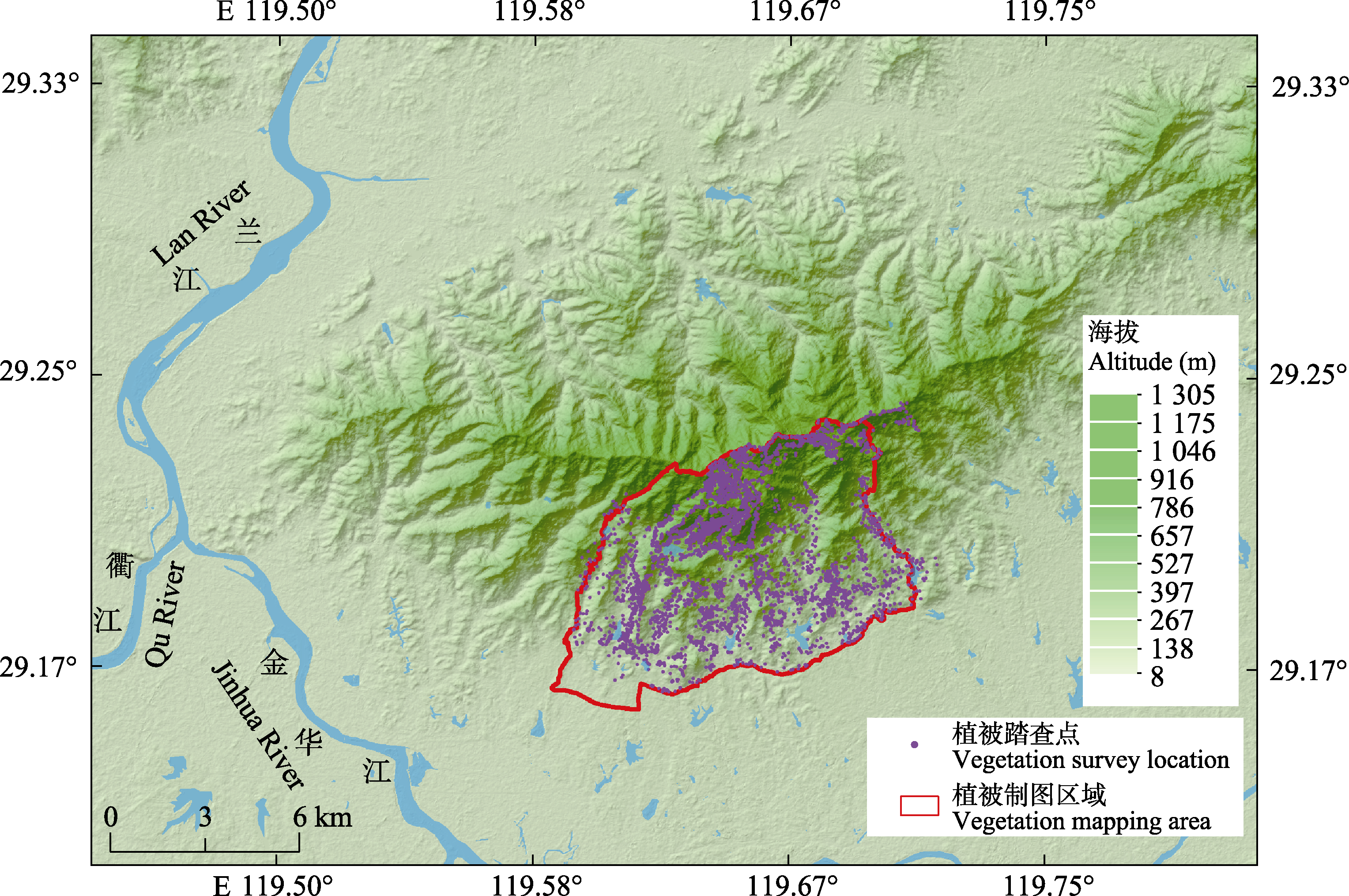
图1 浙江金华北山的地理位置、数字高程模型、植被制图区域和植被踏查样点分布图。
Fig. 1 Geographical location, digital elevation model, vegetation mapping region, and vegetation survey sites of Beishan Mountain in Jinhua, Zhejiang Province.
| 卫星名称 Satellite name | 编号 Serial number | 拍摄时间 Shooting time | 数据类型 Data type | 空间分辨率 Spatial resolution | 级别 Level | 坐标系 Coordinate system | 幅宽 Swath width |
|---|---|---|---|---|---|---|---|
| 高分二号 GF-2 | 1 | 2016-03-01 | 全色+多光谱 Panchromatic + multispectral | 全色: 1 m; 多光谱: 4 m Panchromatic: 1 m; Multispectral: 4 m | 1A | WGS-1984 | 45 km |
| 2 | 2015-12-18 | ||||||
| 3 | 2015-12-18 |
表1 高分二号遥感图像主要参数
Table 1 Key parameters of GF-2 remote sensing image
| 卫星名称 Satellite name | 编号 Serial number | 拍摄时间 Shooting time | 数据类型 Data type | 空间分辨率 Spatial resolution | 级别 Level | 坐标系 Coordinate system | 幅宽 Swath width |
|---|---|---|---|---|---|---|---|
| 高分二号 GF-2 | 1 | 2016-03-01 | 全色+多光谱 Panchromatic + multispectral | 全色: 1 m; 多光谱: 4 m Panchromatic: 1 m; Multispectral: 4 m | 1A | WGS-1984 | 45 km |
| 2 | 2015-12-18 | ||||||
| 3 | 2015-12-18 |
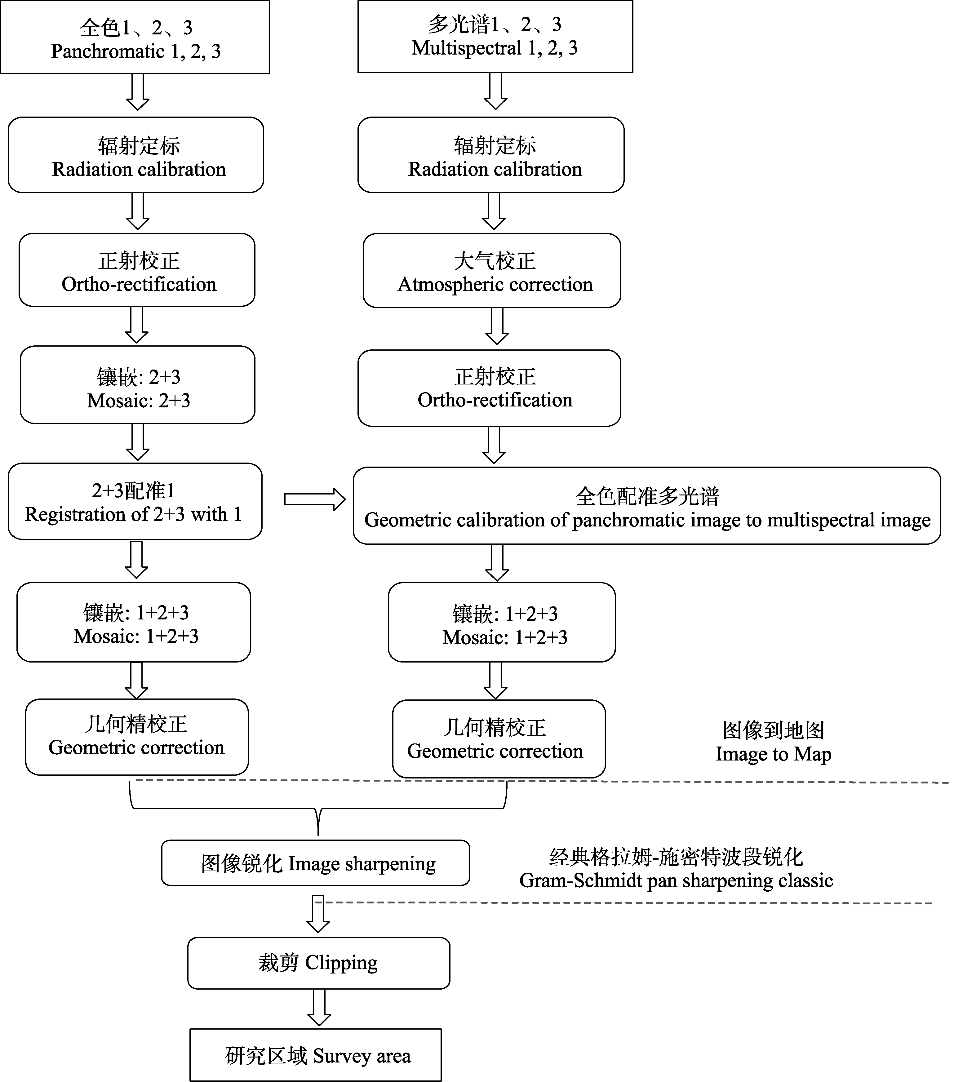
图2 高分二号遥感图像预处理流程。
Fig. 2 Pre-processing flow chart of GF-2 remote sensing image.
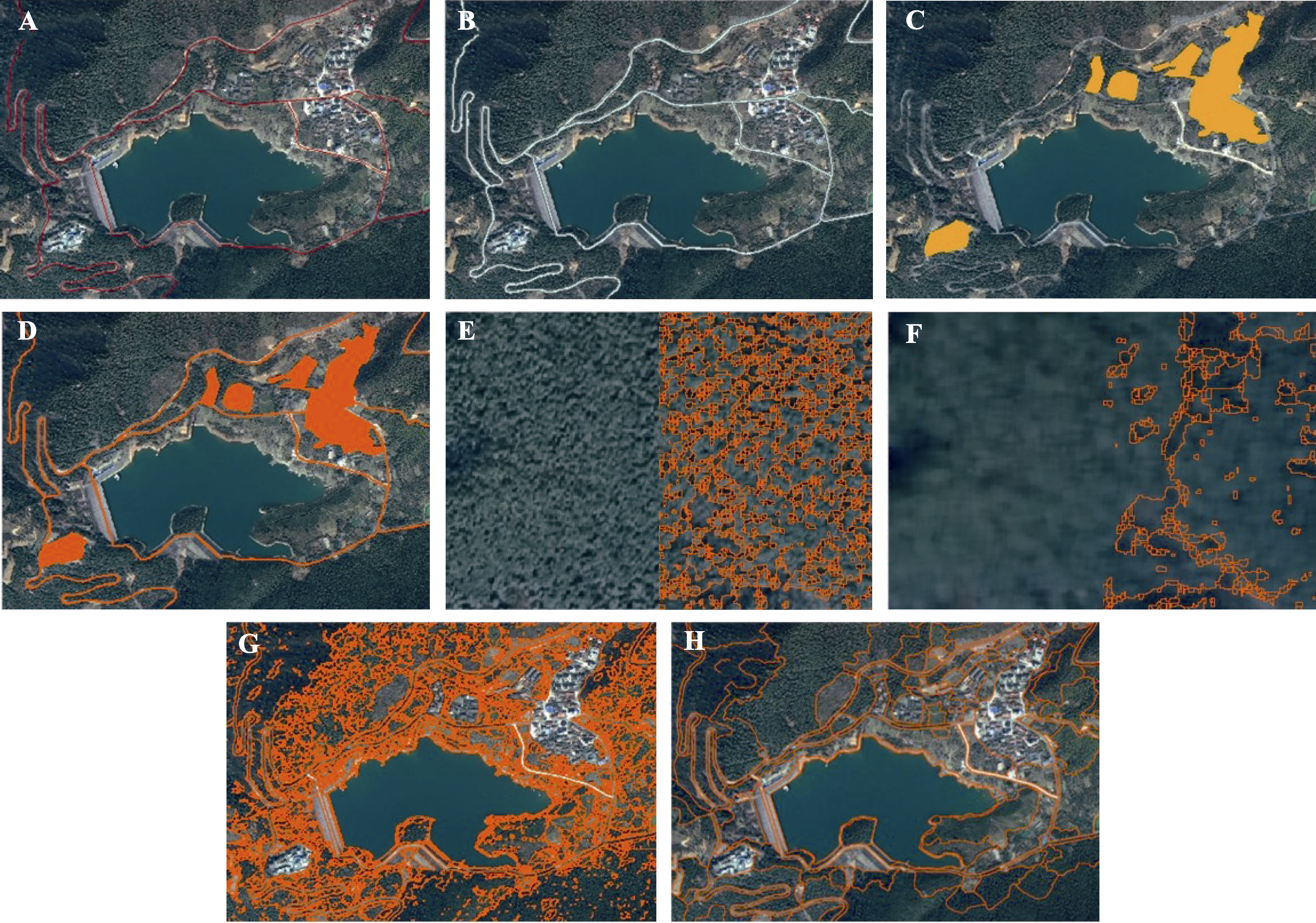
图3 遥感图像信息提取。A, 道路线文件。B, 道路面文件。C, 建筑区面文件。D, 道路和建筑区面文件。E, 阴影噪点及其图像分割效果。F, 中值滤波及其图像分割效果。G, 面向对象图像分割。H, 地物分类效果。
Fig. 3 Information extraction of remote sensing image. A, Road centerline file. B, Road surface file. C, Building area surface file. D, Road and building area surface file. E, Shadow noise and its image segmentation effect. F, Median filtering and its image segmentation effect. G, Object-oriented image segmentation. H, Land cover classification performance.
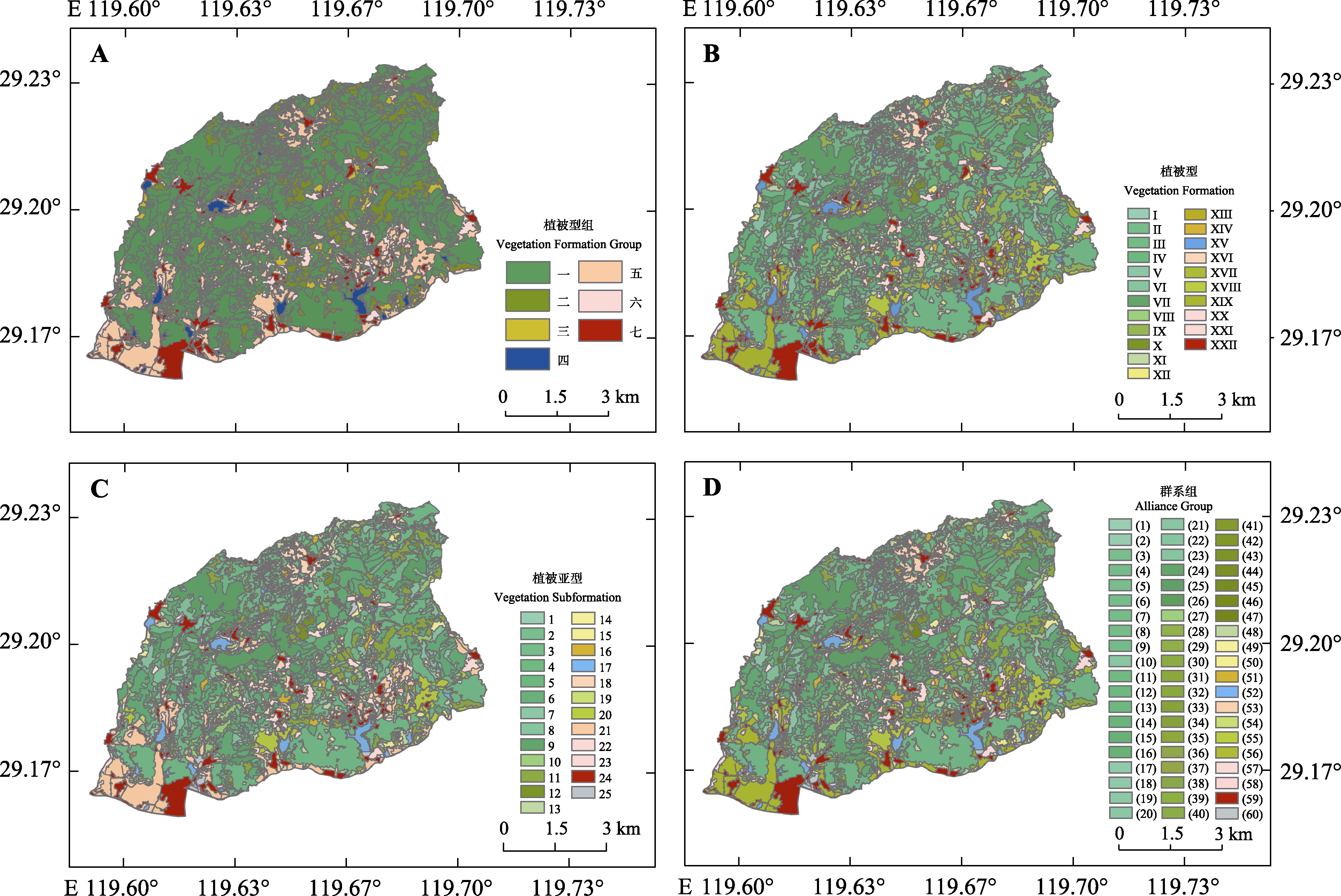
图4 浙江金华北山南坡植被图。A, 植被型组。B, 植被型。C, 植被亚型。D, 群系组。图中编号对应名称见表2。
Fig. 4 Vegetation maps of the southern slope of Beishan Mountain in Jinhua, Zhejiang. A, Vegetation Formation Group. B, Vegetation Formation. C, Vegetation Subformation. D, Alliance Group. The corresponding names of the numbers of vegetation classification units in the figures are shown in Table 2.
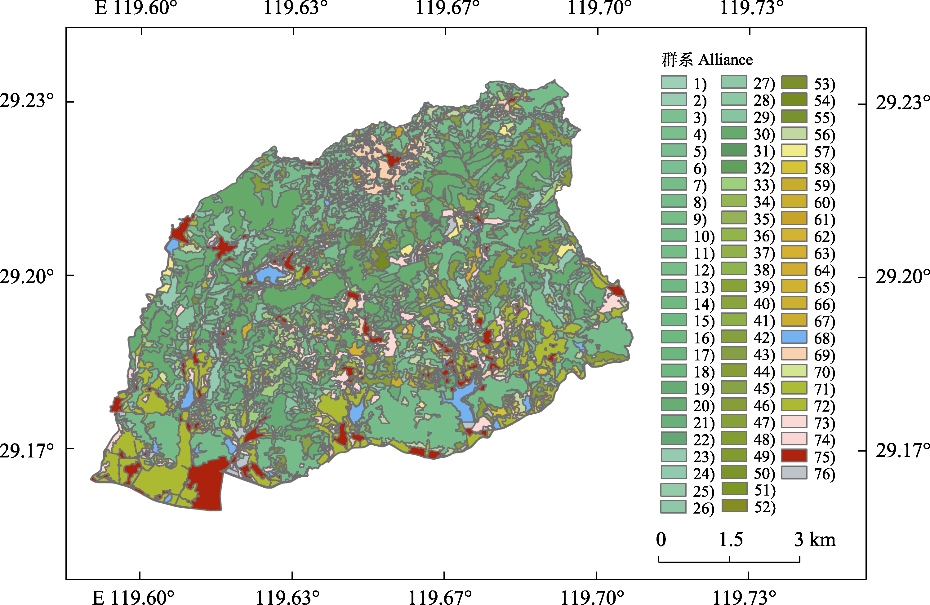
图5 浙江金华北山南坡群系图。图中群系编号对应名称见表2。
Fig. 5 Alliance map of the southern slope of Beishan Mountain in Jinhua, Zhejiang. The corresponding names of the numbers of Alliance in the figure are shown in Table 2.
| 植被型组 Vegetation Formation Group | 植被型 Vegetation Formation | 植被亚型 Vegetation Subformation | 群系组 Alliance Group | 群系 Alliance |
|---|---|---|---|---|
| 一 森林 Forest | I. 落叶针叶林 Deciduous Needleleaf Forest | 1. 暖性落叶针叶林 Subtropical Deciduous Needleleaf Forest | (1) 暖性金钱松林 Subtropical Pseudolarix Forest | 1) 金钱松林 Pseudolarix amabilis Forest |
| (2) 暖性水杉林 Subtropical Metasequoia Forest | 2) 水杉林 Metasequoia glyptostroboides Forest | |||
| II. 常绿针叶林 Evergreen Needleleaf Forest | 2. 温性常绿针叶林 Temperate Evergreen Needleleaf Forest | (3) 温性松林 Temperate Pinus Forest | 3) 黄山松林 Pinus taiwanensis Forest | |
| (4) 温性柳杉林 Temperate Cryptomeria Forest | 4) 柳杉林 Cryptomeria japonica var. sinensis Forest | |||
| (5) 温性扁柏林 Temperate Chamaecyparis Forest | 5) 日本扁柏林 Chamaecyparis obtusa Forest | |||
| 6) 绒柏林 Chamaecyparis pisifera ‘Squarrosa’ Forest | ||||
| 3. 暖性常绿针叶林 Subtropical Evergreen Needleleaf Forest | (6) 暖性松林 Subtropical Pinus Forest | 7) 马尾松林 Pinus massoniana Forest | ||
| (7) 暖性杉木林 Subtropical Cunninghamia Forest | 8) 杉木林 Cunninghamia lanceolata Forest | |||
| (8) 暖性刺柏林 Subtropical Juniperus Forest | 9) 刺柏林 Juniperus formosana Forest | |||
| (9) 暖性柏木林 Subtropical Cupressus Forest | 10) 柏木林 Cupressus funebris Forest | |||
| III. 常绿与落叶针叶混交林 Mixed Evergreen and Deciduous Needleleaf Forest | 4. 温性常绿与落叶针叶混交林 Subtropical Mixed Evergreen and Deciduous Needleleaf Forest | (10) 温性柳杉-落叶针叶混交林 Temperate Cryptomeria - Deciduous Needleleaf Mixed Forest | 11) 柳杉+金钱松林 Cryptomeria japonica var. sinensis + Pseudolarix amabilis Forest | |
| 12) 柳杉+水杉林 Cryptomeria japonica var. sinensis + Metasequoia glyptostroboides Forest | ||||
| IV. 针叶与阔叶混交林 Mixed Needleleaf and Broadleaf Forest | 5. 温性针叶与阔叶混交林 Temperate Mixed Needleleaf and Broadleaf Forest | (11) 温性松-阔叶混交林 Temperate Pinus - Broadleaf Mixed Forest | 13) 黄山松+枫香树+栓皮栎林 Pinus taiwanensis + Liquidambar formosana + Quercus variabilis Forest | |
| 14) 黄山松+木荷混交林 Pinus taiwanensis + Schima superba Forest | ||||
| (12) 温性柳杉-阔叶混交林 Temperate Cryptomeria - Broadleaf Mixed Forest | 15) 柳杉+厚朴林 Cryptomeria japonica var. sinensis + Houpoea officinalis Forest | |||
| 6. 暖性针叶与阔叶混交林 Subtropical Mixed Needleleaf and Broadleaf Forest | (13) 暖性金钱松-阔叶混交林 Subtropical Pseudolarix - Broadleaf Mixed Forest | 16) 金钱松+枫香树林 Pseudolarix amabilis + Liquidambar formosana Forest | ||
| (14) 暖性水杉-阔叶混交林 Subtropical Metasequoia - Broadleaf Mixed Forest | 17) 水杉+枫杨林 Metasequoia glyptostroboides + Pterocarya stenoptera Forest | |||
| 18) 水杉+樟林 Metasequoia glyptostroboides + Camphora officinarum Forest | ||||
| (15) 暖性松-阔叶混交林 Subtropical Pinus - Broadleaf Mixed Forest | 19) 马尾松+落叶阔叶混交林 Pinus massoniana + Deciduous Broadleaf Mixed Forest | |||
| 20) 马尾松+常绿阔叶混交林 Pinus massoniana + Evergreen Broadleaf Mixed Forest | ||||
| (16) 暖性杉木-阔叶混交林 Subtropical Cunninghamia - Broadleaf Mixed Forest | 21) 杉木+落叶阔叶混交林 Cunninghamia lanceolata + Deciduous Broadleaf Mixed Forest | |||
| 22) 杉木+常绿阔叶混交林 Cunninghamia lanceolata + Evergreen Broadleaf Mixed Forest | ||||
| V. 落叶阔叶林 Deciduous Broadleaf Forest | 7. 暖性落叶阔叶林 Subtropical Deciduous Broadleaf Forest | (17) 枫香林 Liquidambar Forest | 23) 枫香树林 Liquidambar formosana Forest | |
| (18) 栎林 Quercus Forest | 24) 栎林 Quercus spp. Forest | |||
| (19) 栗林 Castanea Forest | 25) 栗林 Castanea spp. Forest | |||
| (20) 化香林 Platycarya Forest | 26) 化香树林 Platycarya strobilacea Forest | |||
| (21) 黄檀林 Dalbergia Forest | 27) 黄檀林 Dalbergia hupeana Forest | |||
| (22) 杂木林 Mixed Woods Forest | 28) 杂木人工林 Mixed Woods Artificial Forest | |||
| 一 森林 Forest | VI. 常绿与落叶阔叶混交林 Mixed Evergreen and Deciduous Broadleaf Forest | 8. 亚热带常绿与落叶阔叶混交林 Subtropical Mixed Evergreen and Deciduous Broadleaf Forest | (23) 木荷-落叶阔叶混交林 Schima - Deciduous Broadleaf Mixed Forest | 29) 木荷+落叶阔叶混交林 Schima superba + Deciduous Broadleaf Mixed Forest |
| VII. 常绿阔叶林 Evergreen Broadleaf Forest | 9. 典型亚热带常绿阔叶林 Typical Subtropical Evergreen Broadleaf Forest | (24) 木荷林 Schima Forest | 30) 木荷林 Schima superba Forest | |
| (25) 锥林 Castanopsis Forest | 31) 苦槠林 Castanopsis sclerophylla Forest | |||
| (26) 樟林 Camphora Forest | 32) 樟林 Camphora officinarum Forest | |||
| VIII. 竹林 Bamboo Forest | 10. 暖性竹林 Subtropical Bamboo Forest | (27) 竹林 Bamboo Forest | 33) 毛竹林 Phyllostachys edulis Forest | |
| 二 灌丛 Shrubland | IX. 落叶阔叶灌丛 Deciduous Broadleaf Shrubland | 11. 暖性落叶阔叶灌丛 Subtropical Deciduous Broadleaf Shrubland | (28) 盐肤木灌丛 Rhus Shrubland | 34) 盐麸木灌丛 Rhus chinensis Shrubland |
| (29) 绣线菊灌丛 Spiraea Shrubland | 35) 粉花绣线菊灌丛 Spiraea japonica Shrubland | |||
| (30) 化香树灌丛 Platycarya Shrubland | 36) 化香树灌丛 Platycarya strobilacea Shrubland | |||
| (31) 黄檀灌丛 Dalbergia Shrubland | 37) 黄檀灌丛 Dalbergia hupeana Shrubland | |||
| (32) 胡枝子灌丛 Lespedeza Shrubland | 38) 胡枝子灌丛 Lespedeza bicolor Shrubland | |||
| (33) 绣球灌丛 Hydrangea Shrubland | 39) 圆锥绣球灌丛 Hydrangea paniculata Shrubland | |||
| (34) 八角枫灌丛 Alangium Shrubland | 40) 八角枫灌丛 Alangium chinense Shrubland | |||
| (35) 胡颓子灌丛 Elaeagnus Shrubland | 41) 木半夏灌丛 Elaeagnus multiflora Shrubland | |||
| (36) 山胡椒灌丛 Lindera Shrubland | 42) 红果山胡椒灌丛 Lindera erythrocarpa Shrubland | |||
| 43) 山胡椒灌丛 Lindera glauca Shrubland | ||||
| (37) 木姜子灌丛 Litsea Shrubland | 44) 山鸡椒灌丛 Litsea cubeba Shrubland | |||
| (38) 檵木灌丛 Loropetalum Shrubland | 45) 檵木灌丛 Loropetalum chinense Shrubland | |||
| (39) 牡荆灌丛 Vitex Shrubland | 46) 黄荆灌丛 Vitex negundo Shrubland | |||
| (40) 葛灌丛 Pueraria Shrubland | 47) 葛灌丛 Pueraria montana var. lobata Shrubland | |||
| X. 常绿阔叶灌丛 Evergreen Broadleaf Shrubland | 12. 暖性常绿阔叶灌丛 Subtropical Evergreen Broadleaf Shrubland | (41) 青冈灌丛 Quercus Shrubland | 48) 青冈灌丛 Quercus glauca Shrubland | |
| 49) 褐叶青冈灌丛 Quercus stewardiana Shrubland | ||||
| (42) 柯灌丛 Lithocarpus Shrubland | 50) 短尾柯灌丛 Lithocarpus brevicaudatus Shrubland | |||
| (43) 山茶灌丛 Camellia Shrubland | 51) 毛柄连蕊茶灌丛 Camellia fraterna Shrubland | |||
| (44) 柃灌丛 Eurya Shrubland | 52) 柃灌丛 Eurya spp. Shrubland | |||
| (45) 蒲桃灌丛 Syzygium Shrubland | 53) 赤楠灌丛 Syzygium buxifolium Shrubland | |||
| (46) 杜鹃花灌丛 Rhododendron Shrubland | 54) 马银花灌丛 Rhododendron ovatum Shrubland | |||
| (47) 油麻藤灌丛 Mucuna Shrubland | 55) 油麻藤灌丛 Mucuna sempervirens Shrubland | |||
| XI. 竹丛 Bamboo Shrubland | 13. 暖性竹丛 Subtropical Bamboo Shrubland | (48) 竹丛 Bamboo Shrubland | 56) 竹丛 Bamboo Shrubland | |
| 三 草本植被 Herbaceous Vegetation | XII. 丛生禾草草丛 Tussock Grassland | 14. 亚热带丛生禾草草丛 Subtropical Tussock Grassland | (49) 芒草丛 Miscanthus Tussock Grassland | 57) 芒草丛 Miscanthus sinensis Tussock Grassland |
| XIII. 杂类草草丛 Forb Grassland | 15. 亚热带杂类草草丛 Subtropical Forb Grassland | (50) 杂类草草丛 Forb Grassland | 58) 撂荒杂类草草丛 Abandoned Forb Grassland | |
| XIV. 灌草丛 Shrubby Grassland | 16. 亚热带灌草丛 Subtropical Shrubby Grassland | (51) 禾草灌草丛 Grass Shrubby Grassland | 59) 粉花绣线菊-芒灌草丛 Spiraea japonica - Miscanthus sinensis Shrubby Grassland | |
| 60) 盐麸木-芒灌草丛 Rhus chinensis - Miscanthus sinensis Shrubby Grassland | ||||
| 61) 红果山胡椒-芒灌草丛 Lindera erythrocarpa - Miscanthus sinensis Shrubby Grassland | ||||
| 62) 山胡椒-芒灌草丛 Lindera glauca - Miscanthus sinensis Shrubby Grassland | ||||
| 63) 黄荆-白茅+芒灌草丛 Vitex negundo - Imperata cylindrica + Miscanthus sinensis Shrubby Grassland | ||||
| 64) 黄檀-芒灌草丛 Dalbergia hupeana - Miscanthus sinensis Shrubby Grassland | ||||
| 65) 榔榆-芒灌草丛 Ulmus parvifolia - Miscanthus sinensis Shrubby Grassland | ||||
| 66) 葛-芒灌草丛 Pueraria montana var. lobata - Miscanthus sinensis Shrubby Grassland | ||||
| 67) 竹丛-芒灌草丛 Bamboo - Miscanthus sinensis Shrubby Grassland | ||||
| 四 沼泽与水生植被 Swamp and Aquatic Vegetation | XV. 水生植被 Aquatic Vegetation | 17. 亚热带水生植被 Subtropical Aquatic Vegetation | (52) 水生植被 Aquatic Vegetation | 68) 水体水生植被 Aquatic Vegetation in Water Bodies |
| 五 农业植被 Agricultural Vegetation | XVI. 粮食作物 Food Crop | 18. 亚热带粮食作物 Subtropical Food Crop | (53) 一年两熟水旱粮食作物 Two Crops Annually Containing Upland and Irrigation Food Crops | 69) 水稻、番薯、蔬菜粮食作物 Oryza sativa, Ipomoea batatas, Vegetable Food Crops |
| XVII. 饮料作物 Beverage Crop | 19. 亚热带饮料作物 Subtropical Beverage Crop | (54) 常绿饮料作物 Evergreen Beverage Crop | 70) 茶园 Camellia sinensis Garden | |
| XVIII. 果园 Orchard | 20. 亚热带果园 Subtropical Orchard | (55) 常绿和落叶果园 Evergreen and Deciduous Orchard | 71) 柑橘、佛手、枇杷、杨梅、梨、桃果园 Citrus reticulata, Citrus medica cv. Fingered, Eriobotrya japonica, Myrica rubra, Pyrus spp., Amygdalus persica Orchard | |
| XIX. 花卉园 Flower Garden | 21. 亚热带花卉园 Subtropical Flower Garden | (56) 常绿和落叶花卉苗木园 Evergreen and Deciduous Flower and Nursery Garden | 72) 桂花、茶花、罗汉松、樱花、槭花卉苗木园 Osmanthus fragrans, Camellia japonica, Podocarpus macrophyllus, Prunus spp., Acer spp. Flower and Nursery Garden | |
| 六 城市植被 Urban Vegetation | XX. 城市森林 Urban Forest | 22. 亚热带城市森林 Subtropical Urban Forest | (57) 城市森林 Urban Forest | 73) 城市森林 Urban Forest |
| XXI. 城市行道树和城市公园植被 Urban Street Tree and Urban Park Vegetation | 23. 亚热带城市行道树和城市公园植被 Subtropical Urban Street Tree and Urban Park Vegetation | (58) 城市绿地 Urban Green Space | 74) 城市绿地 Urban Green Space | |
| 七 无植被地段 Non-Vegetated Area | XXII. 无植被地段 Non-Vegetated Area | 24. 道路和建筑 Road and Building | (59) 道路和建筑 Road and Building | 75) 道路和建筑 Road and Building |
| 25. 临时性裸地 Temporary Bare Ground | (60) 临时性裸地 Temporary Bare Ground | 76) 临时性裸地 Temporary Bare Ground |
表2 浙江金华北山南坡植被分类方案
Table 2 Vegetation classification scheme for the southern slope of Beishan Mountain in Jinhua, Zhejiang
| 植被型组 Vegetation Formation Group | 植被型 Vegetation Formation | 植被亚型 Vegetation Subformation | 群系组 Alliance Group | 群系 Alliance |
|---|---|---|---|---|
| 一 森林 Forest | I. 落叶针叶林 Deciduous Needleleaf Forest | 1. 暖性落叶针叶林 Subtropical Deciduous Needleleaf Forest | (1) 暖性金钱松林 Subtropical Pseudolarix Forest | 1) 金钱松林 Pseudolarix amabilis Forest |
| (2) 暖性水杉林 Subtropical Metasequoia Forest | 2) 水杉林 Metasequoia glyptostroboides Forest | |||
| II. 常绿针叶林 Evergreen Needleleaf Forest | 2. 温性常绿针叶林 Temperate Evergreen Needleleaf Forest | (3) 温性松林 Temperate Pinus Forest | 3) 黄山松林 Pinus taiwanensis Forest | |
| (4) 温性柳杉林 Temperate Cryptomeria Forest | 4) 柳杉林 Cryptomeria japonica var. sinensis Forest | |||
| (5) 温性扁柏林 Temperate Chamaecyparis Forest | 5) 日本扁柏林 Chamaecyparis obtusa Forest | |||
| 6) 绒柏林 Chamaecyparis pisifera ‘Squarrosa’ Forest | ||||
| 3. 暖性常绿针叶林 Subtropical Evergreen Needleleaf Forest | (6) 暖性松林 Subtropical Pinus Forest | 7) 马尾松林 Pinus massoniana Forest | ||
| (7) 暖性杉木林 Subtropical Cunninghamia Forest | 8) 杉木林 Cunninghamia lanceolata Forest | |||
| (8) 暖性刺柏林 Subtropical Juniperus Forest | 9) 刺柏林 Juniperus formosana Forest | |||
| (9) 暖性柏木林 Subtropical Cupressus Forest | 10) 柏木林 Cupressus funebris Forest | |||
| III. 常绿与落叶针叶混交林 Mixed Evergreen and Deciduous Needleleaf Forest | 4. 温性常绿与落叶针叶混交林 Subtropical Mixed Evergreen and Deciduous Needleleaf Forest | (10) 温性柳杉-落叶针叶混交林 Temperate Cryptomeria - Deciduous Needleleaf Mixed Forest | 11) 柳杉+金钱松林 Cryptomeria japonica var. sinensis + Pseudolarix amabilis Forest | |
| 12) 柳杉+水杉林 Cryptomeria japonica var. sinensis + Metasequoia glyptostroboides Forest | ||||
| IV. 针叶与阔叶混交林 Mixed Needleleaf and Broadleaf Forest | 5. 温性针叶与阔叶混交林 Temperate Mixed Needleleaf and Broadleaf Forest | (11) 温性松-阔叶混交林 Temperate Pinus - Broadleaf Mixed Forest | 13) 黄山松+枫香树+栓皮栎林 Pinus taiwanensis + Liquidambar formosana + Quercus variabilis Forest | |
| 14) 黄山松+木荷混交林 Pinus taiwanensis + Schima superba Forest | ||||
| (12) 温性柳杉-阔叶混交林 Temperate Cryptomeria - Broadleaf Mixed Forest | 15) 柳杉+厚朴林 Cryptomeria japonica var. sinensis + Houpoea officinalis Forest | |||
| 6. 暖性针叶与阔叶混交林 Subtropical Mixed Needleleaf and Broadleaf Forest | (13) 暖性金钱松-阔叶混交林 Subtropical Pseudolarix - Broadleaf Mixed Forest | 16) 金钱松+枫香树林 Pseudolarix amabilis + Liquidambar formosana Forest | ||
| (14) 暖性水杉-阔叶混交林 Subtropical Metasequoia - Broadleaf Mixed Forest | 17) 水杉+枫杨林 Metasequoia glyptostroboides + Pterocarya stenoptera Forest | |||
| 18) 水杉+樟林 Metasequoia glyptostroboides + Camphora officinarum Forest | ||||
| (15) 暖性松-阔叶混交林 Subtropical Pinus - Broadleaf Mixed Forest | 19) 马尾松+落叶阔叶混交林 Pinus massoniana + Deciduous Broadleaf Mixed Forest | |||
| 20) 马尾松+常绿阔叶混交林 Pinus massoniana + Evergreen Broadleaf Mixed Forest | ||||
| (16) 暖性杉木-阔叶混交林 Subtropical Cunninghamia - Broadleaf Mixed Forest | 21) 杉木+落叶阔叶混交林 Cunninghamia lanceolata + Deciduous Broadleaf Mixed Forest | |||
| 22) 杉木+常绿阔叶混交林 Cunninghamia lanceolata + Evergreen Broadleaf Mixed Forest | ||||
| V. 落叶阔叶林 Deciduous Broadleaf Forest | 7. 暖性落叶阔叶林 Subtropical Deciduous Broadleaf Forest | (17) 枫香林 Liquidambar Forest | 23) 枫香树林 Liquidambar formosana Forest | |
| (18) 栎林 Quercus Forest | 24) 栎林 Quercus spp. Forest | |||
| (19) 栗林 Castanea Forest | 25) 栗林 Castanea spp. Forest | |||
| (20) 化香林 Platycarya Forest | 26) 化香树林 Platycarya strobilacea Forest | |||
| (21) 黄檀林 Dalbergia Forest | 27) 黄檀林 Dalbergia hupeana Forest | |||
| (22) 杂木林 Mixed Woods Forest | 28) 杂木人工林 Mixed Woods Artificial Forest | |||
| 一 森林 Forest | VI. 常绿与落叶阔叶混交林 Mixed Evergreen and Deciduous Broadleaf Forest | 8. 亚热带常绿与落叶阔叶混交林 Subtropical Mixed Evergreen and Deciduous Broadleaf Forest | (23) 木荷-落叶阔叶混交林 Schima - Deciduous Broadleaf Mixed Forest | 29) 木荷+落叶阔叶混交林 Schima superba + Deciduous Broadleaf Mixed Forest |
| VII. 常绿阔叶林 Evergreen Broadleaf Forest | 9. 典型亚热带常绿阔叶林 Typical Subtropical Evergreen Broadleaf Forest | (24) 木荷林 Schima Forest | 30) 木荷林 Schima superba Forest | |
| (25) 锥林 Castanopsis Forest | 31) 苦槠林 Castanopsis sclerophylla Forest | |||
| (26) 樟林 Camphora Forest | 32) 樟林 Camphora officinarum Forest | |||
| VIII. 竹林 Bamboo Forest | 10. 暖性竹林 Subtropical Bamboo Forest | (27) 竹林 Bamboo Forest | 33) 毛竹林 Phyllostachys edulis Forest | |
| 二 灌丛 Shrubland | IX. 落叶阔叶灌丛 Deciduous Broadleaf Shrubland | 11. 暖性落叶阔叶灌丛 Subtropical Deciduous Broadleaf Shrubland | (28) 盐肤木灌丛 Rhus Shrubland | 34) 盐麸木灌丛 Rhus chinensis Shrubland |
| (29) 绣线菊灌丛 Spiraea Shrubland | 35) 粉花绣线菊灌丛 Spiraea japonica Shrubland | |||
| (30) 化香树灌丛 Platycarya Shrubland | 36) 化香树灌丛 Platycarya strobilacea Shrubland | |||
| (31) 黄檀灌丛 Dalbergia Shrubland | 37) 黄檀灌丛 Dalbergia hupeana Shrubland | |||
| (32) 胡枝子灌丛 Lespedeza Shrubland | 38) 胡枝子灌丛 Lespedeza bicolor Shrubland | |||
| (33) 绣球灌丛 Hydrangea Shrubland | 39) 圆锥绣球灌丛 Hydrangea paniculata Shrubland | |||
| (34) 八角枫灌丛 Alangium Shrubland | 40) 八角枫灌丛 Alangium chinense Shrubland | |||
| (35) 胡颓子灌丛 Elaeagnus Shrubland | 41) 木半夏灌丛 Elaeagnus multiflora Shrubland | |||
| (36) 山胡椒灌丛 Lindera Shrubland | 42) 红果山胡椒灌丛 Lindera erythrocarpa Shrubland | |||
| 43) 山胡椒灌丛 Lindera glauca Shrubland | ||||
| (37) 木姜子灌丛 Litsea Shrubland | 44) 山鸡椒灌丛 Litsea cubeba Shrubland | |||
| (38) 檵木灌丛 Loropetalum Shrubland | 45) 檵木灌丛 Loropetalum chinense Shrubland | |||
| (39) 牡荆灌丛 Vitex Shrubland | 46) 黄荆灌丛 Vitex negundo Shrubland | |||
| (40) 葛灌丛 Pueraria Shrubland | 47) 葛灌丛 Pueraria montana var. lobata Shrubland | |||
| X. 常绿阔叶灌丛 Evergreen Broadleaf Shrubland | 12. 暖性常绿阔叶灌丛 Subtropical Evergreen Broadleaf Shrubland | (41) 青冈灌丛 Quercus Shrubland | 48) 青冈灌丛 Quercus glauca Shrubland | |
| 49) 褐叶青冈灌丛 Quercus stewardiana Shrubland | ||||
| (42) 柯灌丛 Lithocarpus Shrubland | 50) 短尾柯灌丛 Lithocarpus brevicaudatus Shrubland | |||
| (43) 山茶灌丛 Camellia Shrubland | 51) 毛柄连蕊茶灌丛 Camellia fraterna Shrubland | |||
| (44) 柃灌丛 Eurya Shrubland | 52) 柃灌丛 Eurya spp. Shrubland | |||
| (45) 蒲桃灌丛 Syzygium Shrubland | 53) 赤楠灌丛 Syzygium buxifolium Shrubland | |||
| (46) 杜鹃花灌丛 Rhododendron Shrubland | 54) 马银花灌丛 Rhododendron ovatum Shrubland | |||
| (47) 油麻藤灌丛 Mucuna Shrubland | 55) 油麻藤灌丛 Mucuna sempervirens Shrubland | |||
| XI. 竹丛 Bamboo Shrubland | 13. 暖性竹丛 Subtropical Bamboo Shrubland | (48) 竹丛 Bamboo Shrubland | 56) 竹丛 Bamboo Shrubland | |
| 三 草本植被 Herbaceous Vegetation | XII. 丛生禾草草丛 Tussock Grassland | 14. 亚热带丛生禾草草丛 Subtropical Tussock Grassland | (49) 芒草丛 Miscanthus Tussock Grassland | 57) 芒草丛 Miscanthus sinensis Tussock Grassland |
| XIII. 杂类草草丛 Forb Grassland | 15. 亚热带杂类草草丛 Subtropical Forb Grassland | (50) 杂类草草丛 Forb Grassland | 58) 撂荒杂类草草丛 Abandoned Forb Grassland | |
| XIV. 灌草丛 Shrubby Grassland | 16. 亚热带灌草丛 Subtropical Shrubby Grassland | (51) 禾草灌草丛 Grass Shrubby Grassland | 59) 粉花绣线菊-芒灌草丛 Spiraea japonica - Miscanthus sinensis Shrubby Grassland | |
| 60) 盐麸木-芒灌草丛 Rhus chinensis - Miscanthus sinensis Shrubby Grassland | ||||
| 61) 红果山胡椒-芒灌草丛 Lindera erythrocarpa - Miscanthus sinensis Shrubby Grassland | ||||
| 62) 山胡椒-芒灌草丛 Lindera glauca - Miscanthus sinensis Shrubby Grassland | ||||
| 63) 黄荆-白茅+芒灌草丛 Vitex negundo - Imperata cylindrica + Miscanthus sinensis Shrubby Grassland | ||||
| 64) 黄檀-芒灌草丛 Dalbergia hupeana - Miscanthus sinensis Shrubby Grassland | ||||
| 65) 榔榆-芒灌草丛 Ulmus parvifolia - Miscanthus sinensis Shrubby Grassland | ||||
| 66) 葛-芒灌草丛 Pueraria montana var. lobata - Miscanthus sinensis Shrubby Grassland | ||||
| 67) 竹丛-芒灌草丛 Bamboo - Miscanthus sinensis Shrubby Grassland | ||||
| 四 沼泽与水生植被 Swamp and Aquatic Vegetation | XV. 水生植被 Aquatic Vegetation | 17. 亚热带水生植被 Subtropical Aquatic Vegetation | (52) 水生植被 Aquatic Vegetation | 68) 水体水生植被 Aquatic Vegetation in Water Bodies |
| 五 农业植被 Agricultural Vegetation | XVI. 粮食作物 Food Crop | 18. 亚热带粮食作物 Subtropical Food Crop | (53) 一年两熟水旱粮食作物 Two Crops Annually Containing Upland and Irrigation Food Crops | 69) 水稻、番薯、蔬菜粮食作物 Oryza sativa, Ipomoea batatas, Vegetable Food Crops |
| XVII. 饮料作物 Beverage Crop | 19. 亚热带饮料作物 Subtropical Beverage Crop | (54) 常绿饮料作物 Evergreen Beverage Crop | 70) 茶园 Camellia sinensis Garden | |
| XVIII. 果园 Orchard | 20. 亚热带果园 Subtropical Orchard | (55) 常绿和落叶果园 Evergreen and Deciduous Orchard | 71) 柑橘、佛手、枇杷、杨梅、梨、桃果园 Citrus reticulata, Citrus medica cv. Fingered, Eriobotrya japonica, Myrica rubra, Pyrus spp., Amygdalus persica Orchard | |
| XIX. 花卉园 Flower Garden | 21. 亚热带花卉园 Subtropical Flower Garden | (56) 常绿和落叶花卉苗木园 Evergreen and Deciduous Flower and Nursery Garden | 72) 桂花、茶花、罗汉松、樱花、槭花卉苗木园 Osmanthus fragrans, Camellia japonica, Podocarpus macrophyllus, Prunus spp., Acer spp. Flower and Nursery Garden | |
| 六 城市植被 Urban Vegetation | XX. 城市森林 Urban Forest | 22. 亚热带城市森林 Subtropical Urban Forest | (57) 城市森林 Urban Forest | 73) 城市森林 Urban Forest |
| XXI. 城市行道树和城市公园植被 Urban Street Tree and Urban Park Vegetation | 23. 亚热带城市行道树和城市公园植被 Subtropical Urban Street Tree and Urban Park Vegetation | (58) 城市绿地 Urban Green Space | 74) 城市绿地 Urban Green Space | |
| 七 无植被地段 Non-Vegetated Area | XXII. 无植被地段 Non-Vegetated Area | 24. 道路和建筑 Road and Building | (59) 道路和建筑 Road and Building | 75) 道路和建筑 Road and Building |
| 25. 临时性裸地 Temporary Bare Ground | (60) 临时性裸地 Temporary Bare Ground | 76) 临时性裸地 Temporary Bare Ground |
| [1] | de Colstoun ECB, Story MH, Thompson C, Commisso K, Smith TG, Irons JR (2003). National Park vegetation mapping using multitemporal Landsat 7 data and a decision tree classifier. Remote Sensing of Environment, 85, 316-327. |
| [2] | Deng MD (2022). Vegetation Classification and 1:50000 Vegetation Map Drawing in the Ecological “Green-Core” Area of Changzhutan Urban Cluster. Master degree dissertation, Central South University of Forestry & Technology, Changsha. |
| [邓梦达 (2022). 长株潭绿心区植被分类及1: 50000植被图绘制. 硕士学位论文, 中南林业科技大学, 长沙.] | |
| [3] | Deng SB, Chen QJ, Du HJ, Xu EH (2014). ENVI Method of Remote Sensing Image Processing. 2nd ed. Higher Education Press, Beijing. 60-67, 132-150. |
| [邓书斌, 陈秋锦, 杜会建, 徐恩惠 (2014). ENVI遥感图像处理方法. 2版. 高等教育出版社, 北京. 60-67, 132-150.] | |
| [4] | Fan HD, Chen HY, Wu YN, Liu JF, Xu DY, Cao JY, Yuan Q, Tan B, Liu XT, Xu J, Wang GM, Han WJ, Liu LB, Ni J (2019). Community characteristics of main vegetation types on the southern slope of Beishan Mountain in Jinhua, Zhejiang, China. Chinese Journal of Plant Ecology, 43, 921-928. |
|
[樊海东, 陈海燕, 吴雁南, 刘建峰, 徐德宇, 曹嘉瑜, 袁泉, 谭斌, 刘晓彤, 徐佳, 王国敏, 韩文娟, 刘立斌, 倪健 (2019). 金华北山南坡主要植被类型的群落特征. 植物生态学报, 43, 921-928.]
DOI |
|
| [5] | Fang JY, Guo K, Wang GH, Tang ZY, Xie ZQ, Shen ZH, Wang RQ, Qiang S, Liang CZ, Da LJ, Yu D (2020). Vegetation classification system and classification of vegetation types used for the compilation of vegetation of China. Chinese Journal of Plant Ecology, 44, 96-110. |
|
[方精云, 郭柯, 王国宏, 唐志尧, 谢宗强, 沈泽昊, 王仁卿, 强胜, 梁存柱, 达良俊, 于丹 (2020). 《中国植被志》的植被分类系统、植被类型划分及编排体系. 植物生态学报, 44, 96-110.]
DOI |
|
| [6] |
Guo K, Fang JY, Wang GH, Tang ZY, Xie ZQ, Shen ZH, Wang RQ, Qiang S, Liang CZ, Da LJ, Yu D (2020). A revised scheme of vegetation classification system of China. Chinese Journal of Plant Ecology, 44, 111-127.
DOI |
|
[郭柯, 方精云, 王国宏, 唐志尧, 谢宗强, 沈泽昊, 王仁卿, 强胜, 梁存柱, 达良俊, 于丹 (2020). 中国植被分类系统修订方案. 植物生态学报, 44, 111-127.]
DOI |
|
| [7] | Guo QH, Guan HC, Hu TY, Jin SC, Su YJ, Wang XJ, Wei DJ, Ma Q, Sun QH (2021). Remote sensing-based mapping for the new generation of Vegetation Map of China (1:500,000). Scientia Sinica (Vitae), 51, 229-241. |
| [郭庆华, 关宏灿, 胡天宇, 金时超, 苏艳军, 王雪静, 魏邓杰, 马勤, 孙千惠 (2021). 新一代1:50万中国植被图绘制方法探讨. 中国科学: 生命科学, 51, 229-241.] | |
| [8] | Guo YF, Wu TJ, Luo JC, Shi HN, Gao LJ (2022). Remote sensing mapping of mountain vegetation via uncertainty-based iterative optimization. Journal of Geo-Information Science, 24, 1406-1419. |
|
[郭逸飞, 吴田军, 骆剑承, 石含宁, 郜丽静 (2022). 基于不确定性迭代优化的山地植被遥感制图. 地球信息科学学报, 24, 1406-1419.]
DOI |
|
| [9] | Hou XY (1960). China’s Vegetation. People’s Education Press, Beijing. |
| [侯学煜 (1960). 中国的植被. 人民教育出版社, 北京.] | |
| [10] | Hou XY (2001). Vegetation Atlas of China (1:1000000). Science Press, Beijing. |
| [侯学煜 (2001). 1:1000000 中国植被图集. 科学出版社, 北京.] | |
| [11] | Hou XY, Ma RZ (1956). Wall Map of Vegetation-Soil Regionalization in China (1:4000000). Map Publishing House, Beijing. |
| [侯学煜, 马溶之 (1956). 中国植被-土壤分区挂图(1: 400万). 地图出版社, 北京.] | |
| [12] | Hou XY, Sun SZ, Zhang JW, He MG, Wang YF, Sun DZ, Wang SQ (1979). Vegetation Map of the People’s Republic of China (1:4000000). Map Publishing House, Beijing. |
| [侯学煜, 孙世洲, 张经炜, 何妙光, 王义风, 孙德珍, 王绍庆 (1979). 中华人民共和国植被图(1: 4000000). 地图出版社, 北京.] | |
| [13] | Institute of Botany, Chinese Academy of Sciences(1980). Application of remote sensing method in vegetation mapping. Agricultural Regional Planning, (3), 44-50. |
| [中国科学院植物研究所 (1980). 遥感方法在植被制图中的应用. 农业区划, (3), 44-50.] | |
| [14] | Jia NX, Guo K, Song CY, Liu CC (2021). Principles of color and symbol design for vegetation mapping and a scheme of national vegetation map legends. Chinese Journal of Plant Ecology, 45, 809-817. |
|
[贾宁霞, 郭柯, 宋创业, 刘长成 (2021). 植被制图色彩和符号设计原则与全国植被图图例方案. 植物生态学报, 45, 809-817.]
DOI |
|
| [15] | Ma KP, Guo QH (2021). Progress and recent trends of vegetation ecology in China. Scientia Sinica (Vitae), 51, 215-218. |
| [马克平, 郭庆华 (2021). 中国植被生态学研究的进展和趋势. 中国科学: 生命科学, 51, 215-218.] | |
| [16] | Malan OG, Westfall RH (1987). A new strategy for vegetation mapping with the aid of Landsat MSS data. Advances in Space Research, 7, 97-103. |
| [17] | Rodriguez-Galiano VF, Chica-Olmo M, Abarca-Hernandez F, Atkinson PM, Jeganathan C (2012). Random Forest classification of Mediterranean land cover using multi-seasonal imagery and multi-seasonal texture. Remote Sensing of Environment, 121, 93-107. |
| [18] | Sang JW, Song CY, Jia NX, Jia Y, Liu CC, Qiao XG, Zhang L, Yuan WY, Wu DX, Li LH, Guo K (2023). Vegetation survey and mapping on the Qinghai-Tibet Plateau. Biodiversity Science, 31, 22430. DOI: 10.17520/biods. 2022430. |
| [桑佳文, 宋创业, 贾宁霞, 贾元, 刘长成, 乔鲜果, 张琳, 袁伟影, 吴冬秀, 李凌浩, 郭柯 (2023). 青藏高原植被调查与制图评估. 生物多样性, 31, 22430. DOI: 10.17520/biods.2022430.] | |
| [19] | Shi JX (2021). Vegetation Classification and Mapping of Zhoushan Archipelago. Master degree dissertation, East China Normal University, Shanghai. |
| [石娇星 (2021). 舟山群岛植被分类与制图. 硕士学位论文, 华东师范大学, 上海.] | |
| [20] | Song YC (2004). Tentative classification scheme of evergreen broad-leaved forests of China. Acta Phytoecologica Sinica, 28, 435-448. |
|
[宋永昌 (2004). 中国常绿阔叶林分类试行方案. 植物生态学报, 28, 435-448.]
DOI |
|
| [21] | Song YC (2013). Evergreen Broad-leaved Forests in China: Classification, Ecology, Conservation. Science Press, Beijing. |
| [宋永昌 (2013). 中国常绿阔叶林: 分类·生态·保育. 科学出版社, 北京.] | |
| [22] | Song YC (2017). Vegetation Ecology. 2nd ed. Higher Education Press, Beijing. |
| [宋永昌 (2017). 植被生态学. 2版. 高等教育出版社, 北京.] | |
| [23] |
Su YJ, Guo QH, Hu TY, Guan HC, Jin SC, An SZ, Chen XL, Guo K, Hao ZQ, Hu YM, Huang YM, Jiang MX, Li JX, Li ZJ, Li XK, et al. (2020). An updated vegetation map of China (1:1000000). Science Bulletin, 65, 1125-1136.
DOI PMID |
| [24] | Sun XH, Shi JK, Li XW, Wu WJ, Liang L, Gong C (2021). Mapping and dynamic changes of refined vegetation distribution in Xisha Islands. National Remote Sensing Bulletin, 25, 1473-1488. |
| [孙晓慧, 史建康, 李新武, 吴文瑾, 梁雷, 宫晨 (2021). 西沙群岛精细植被分布的遥感制图及动态变化. 遥感学报, 25, 1473-1488.] | |
| [25] | The Editorial Committee of Vegetation Map of China, Chinese Academy of Sciences(2007). Vegetation Map of the People’s Republic of China 1:1000000. Geological Publishing House, Beijing. |
| [中国科学院中国植被图编辑委员会 (2007). 中华人民共和国植被图1:1000000. 地质出版社, 北京.] | |
| [26] | The Editorial Committee of Vegetation of China (1980). Vegetation of China. Science Press, Beijing. |
| [中国植被编辑委员会 (1980). 中国植被. 科学出版社, 北京.] | |
| [27] | Tian LS (1993). Vegetation Mapping. Xi’an Map Press, Xi’an. |
| [田连恕 (1993). 植被制图. 西安地图出版社, 西安.] | |
| [28] | Wang H, Wang CB, Wu HG (2016). Using GF-2 imagery and the conditional random field model for urban forest cover mapping. Remote Sensing Letters, 7, 378-387. |
| [29] | Wang L, Dong L, Hu TY, Guo K (2021a). History and prospect of vegetation map compilation in China. Scientia Sinica (Vitae), 51, 219-228. |
| [王乐, 董雷, 胡天宇, 郭柯 (2021a). 中国植被图编研历史与展望. 中国科学: 生命科学, 51, 219-228.] | |
| [30] | Wang L, Dong L, Zhao ZP, Lu SZ, Wang J, Liu YG, Jin SC, Guan HC, Guo K (2021b). Vegetation diversity and mapping in the priority area of Taihang Mountains biodiversity conservation (Beijing-Tianjin-Hebei region). Scientia Sinica (Vitae), 51, 289-299. |
| [王乐, 董雷, 赵志平, 陆帅志, 王静, 刘永刚, 金时超, 关宏灿, 郭柯 (2021b). 太行山生物多样性保护优先区域京津冀地区植被多样性与植被制图. 中国科学: 生命科学, 51, 289-299.] | |
| [31] |
Xie YC, Sha ZY, Yu M (2008). Remote sensing imagery in vegetation mapping: a review. Journal of Plant Ecology, 1, 9-23.
DOI |
| [32] | Xu MS, Zhu XT, Wang WS, Du YC, Wang YY, Liang QM, Zheng LT, Yan ER (2022). Vegetation classification and mapping of Dajinshan Island: a grid inventory-based approach. Guihaia, 42, 1273-1283. |
| [许洺山, 朱晓彤, 王万胜, 杜运才, 汪彦颖, 梁启明, 郑丽婷, 阎恩荣 (2022). 上海大金山岛植被分类与制图——基于网格化清查方法. 广西植物, 42, 1273-1283.] | |
| [33] | Yao YH, Zhang JY, Suonan DZ (2020). Compilation of 1:50000 vegetation type map with remote sensing images based on mountain altitudinal belts of Taibai Mountain in the north-south transitional zone of China. Acta Geographica Sinica, 75, 620-630. |
|
[姚永慧, 张俊瑶, 索南东主 (2020). 南北过渡带1:5万植被类型图遥感制图案例研究. 地理学报, 75, 620-630.]
DOI |
|
| [34] | Ying XF, Liu P, Guo SL, Chen JH, Lu HF (2006). Study on the woody plant flora of Beishan Mount of Jinhua in Zhejiang Province. Journal of Shanghai Jiaotong University (Agricultural Science), 24, 39-43. |
| [应小芳, 刘鹏, 郭水良, 陈建华, 吕洪飞 (2006). 浙江金华北山木本植物区系研究. 上海交通大学学报(农业科学版), 24, 39-43.] | |
| [35] | Zhang H, Zhao CL, Zhu WQ (2021). A new vegetation map for Qinghai-Tibet Plateau by integrated classification from multi-source data products. Journal of Beijing Normal University (Natural Science), 57, 816-824. |
| [张慧, 赵涔良, 朱文泉 (2021). 基于多源数据产品集成分类制作的青藏高原现状植被图. 北京师范大学学报(自然科学版), 57, 816-824.] | |
| [36] | Zhang XL, Zhou JH, Cai WT, Gao NN, Zheng YR (2018). Vegetation mapping (1:100000) in Heihe River Basin using 3S technology. Journal of Northwest Normal University (Natural Science), 54(2), 95-101. |
| [张晓龙, 周继华, 蔡文涛, 高楠楠, 郑元润 (2018). 基于3S技术的黑河流域1:100000植被制图. 西北师范大学学报(自然科学版), 54(2), 95-101.] |
| [1] | 杜燕 刘鑫 张瀚曰 马少伟 包维楷. 中国高山松群系的群落特征[J]. 植物生态学报, 2025, 49(植被): 1-0. |
| [2] | 董劭琼, 侯东杰, 曲孝云, 郭柯. 柴达木盆地植物群落样方数据集[J]. 植物生态学报, 2024, 48(4): 534-540. |
| [3] | 兰光飞 张强 陈相标 陈仕东 熊德成 刘小飞 杨智杰 杨玉盛. 中亚热带格氏栲林凋落物季节动态特征及其影响因素[J]. 植物生态学报, 2024, 48(12): 1589-1601. |
| [4] | 陈昭铨, 王明慧, 胡子涵, 郎学东, 何云琼, 刘万德. 云南普洱季风常绿阔叶林幼苗的群落构建机制[J]. 植物生态学报, 2024, 48(1): 68-79. |
| [5] | 仲琦, 李曾燕, 马炜, 况雨潇, 邱岭军, 黎蕴洁, 涂利华. 氮添加和凋落物处理对华西雨屏区常绿阔叶林凋落叶分解的影响[J]. 植物生态学报, 2023, 47(5): 629-643. |
| [6] | 郝晴, 黄昌. 森林地上生物量遥感估算研究综述[J]. 植物生态学报, 2023, 47(10): 1356-1374. |
| [7] | 金伊丽, 王皓言, 魏临风, 侯颖, 胡景, 吴铠, 夏昊钧, 夏洁, 周伯睿, 李凯, 倪健. 青藏高原植物群落样方数据集[J]. 植物生态学报, 2022, 46(7): 846-854. |
| [8] | 王国宏, 郭柯, 谢宗强, 唐志尧, 蒋延玲, 方精云. 《中国植被志》研编规范的若干说明、补充与修订[J]. 植物生态学报, 2022, 46(3): 368-372. |
| [9] | 丛楠, 张扬建, 朱军涛. 北半球中高纬度地区近30年植被春季物候温度敏感性[J]. 植物生态学报, 2022, 46(2): 125-135. |
| [10] | 姜艳, 陈兴芳, 杨旭杰. 基于Landsat影像的武汉东湖30年来水生植物动态变化[J]. 植物生态学报, 2022, 46(12): 1551-1561. |
| [11] | 田佳玉, 王彬, 张志明, 林露湘. 光谱多样性在植物多样性监测与评估中的应用[J]. 植物生态学报, 2022, 46(10): 1129-1150. |
| [12] | 严正兵, 刘树文, 吴锦. 高光谱遥感技术在植物功能性状监测中的应用与展望[J]. 植物生态学报, 2022, 46(10): 1151-1166. |
| [13] | 贺忠权, 刘长成, 蔡先立, 郭柯. 黔中高原喀斯特常绿与落叶阔叶混交林类型及群落特征[J]. 植物生态学报, 2021, 45(6): 670-680. |
| [14] | 陈哲, 汪浩, 王金洲, 石慧瑾, 刘慧颖, 贺金生. 基于物候相机归一化植被指数估算高寒草地植物地上生物量的季节动态[J]. 植物生态学报, 2021, 45(5): 487-495. |
| [15] | 朱华. 云南常绿阔叶林的植被地理研究[J]. 植物生态学报, 2021, 45(3): 224-241. |
| 阅读次数 | ||||||
|
全文 |
|
|||||
|
摘要 |
|
|||||
Copyright © 2022 版权所有 《植物生态学报》编辑部
地址: 北京香山南辛村20号, 邮编: 100093
Tel.: 010-62836134, 62836138; Fax: 010-82599431; E-mail: apes@ibcas.ac.cn, cjpe@ibcas.ac.cn
备案号: 京ICP备16067583号-19