
植物生态学报 ›› 2010, Vol. 34 ›› Issue (7): 800-810.DOI: 10.3773/j.issn.1005-264x.2010.07.005
唐丽霞1,3,*( ), 张志强1,**(), 王新杰2, 王盛萍4, 查同刚1
收稿日期:2009-10-13
接受日期:2010-03-01
出版日期:2010-10-13
发布日期:2010-07-01
通讯作者:
张志强
作者简介:** E-mail: zhqzhang@bjfu.edu.cn
TANG Li-Xia1,3,*(), ZHANG Zhi-Qiang1,**(), WANG Xin-Jie2, WANG Sheng-Ping4, ZHA Tong-Gang1
Received:2009-10-13
Accepted:2010-03-01
Online:2010-10-13
Published:2010-07-01
Contact:
ZHANG Zhi-Qiang
摘要:
水资源短缺是黄土高原面临的最为关键的一个生态环境问题。研究黄土高原地区河川径流演变对土地利用与气候变化的响应是开展适应性流域管理的基础。该文以黄河流域中游山西省吉县境内的清水河流域(面积436 km2)为研究对象, 采用非参数统计秩检验法(Mann-Kendall)、滑动t检验和跃变参数分析法, 对该流域1959-2005年的年径流量、降水量和潜在蒸发散量进行了趋势分析和突变点验证; 用遥感数据判读和解译的结果分析了该流域不同时期土地利用变化; 在此基础上根据水量平衡原理, 分析了土地利用变化和气候变化对流域径流变化的贡献, 并采用FDC曲线法分析了二者对高、中、低流量变化的影响。研究结果表明: 该流域年径流量在1959-2005年的47年间呈显著下降趋势, 突变点出现在1980年, 但该流域降水量没有出现明显的趋势性变化, 而以Hamon公式计算的流域年潜在蒸发散则呈显著上升趋势, 其突变点出现在1997年。该流域气候变化和土地利用变化对年径流减少的贡献率分别为46.79%和53.21%。综合以上结果可以看出, 潜在蒸发散增加和乔木林地面积增加是导致该流域径流减少的重要原因。
唐丽霞, 张志强, 王新杰, 王盛萍, 查同刚. 晋西黄土高原丘陵沟壑区清水河流域径流对土地利用与气候变化的响应. 植物生态学报, 2010, 34(7): 800-810. DOI: 10.3773/j.issn.1005-264x.2010.07.005
TANG Li-Xia, ZHANG Zhi-Qiang, WANG Xin-Jie, WANG Sheng-Ping, ZHA Tong-Gang. Streamflow response to climate and landuse changes in Qingshui River watershed in the loess hilly-gully region of Western Shanxi Province, China. Chinese Journal of Plant Ecology, 2010, 34(7): 800-810. DOI: 10.3773/j.issn.1005-264x.2010.07.005
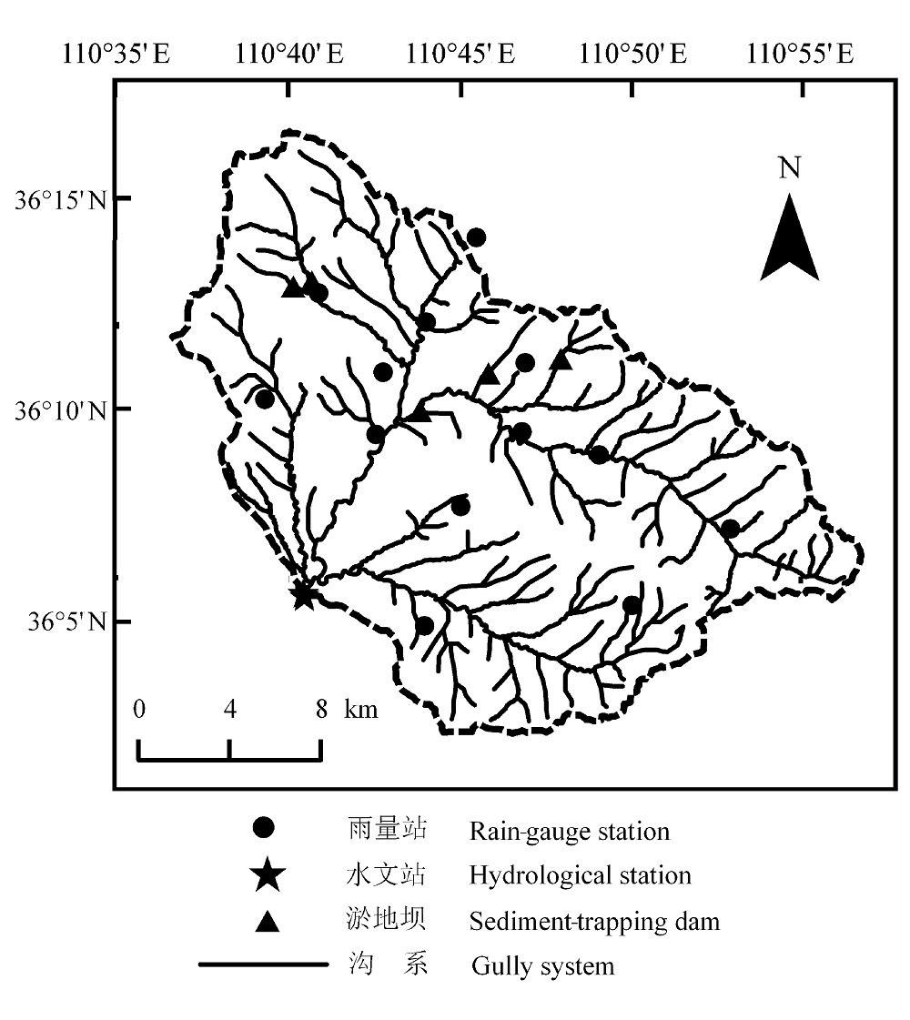
图1 清水河流域的地理位置。
Fig. 1 Geographical position of Qingshui River watershed.
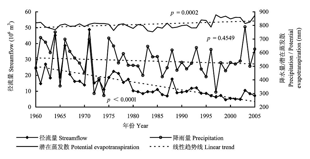
图2 年径流量、潜在蒸发散和降水量变化及其各自的线性趋势。
Fig. 2 Annual variation of streamflow, potential evapotranspiration, and precipitation with their respective linear regression line.
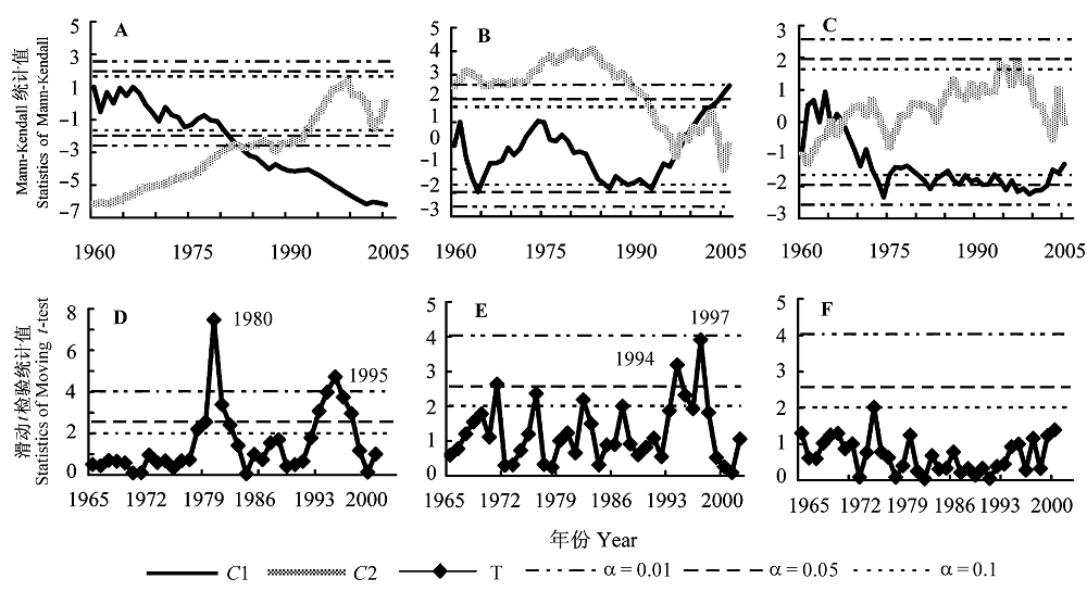
图3 1960-2005年清水河流域年径流量、潜在蒸发散、降水量趋势分析。 A-C, 径流量、潜在蒸发散、降水量Mann-Kendall检验曲线。D-F, 径流量、潜在蒸发散、降水量滑动t检验曲线。C1, Mann-Kendall统计值组成的曲线; C2, Mann-Kendall反序列统计值组成的曲线; T, 滑动t检验的统计值; α, 显著性水平。
Fig. 3 Trend of annual streamflow, potential evapotranspiration, and precipitation in Qingshui River watershed from 1960 to 2005. A-C, The Mann-Kendall curves of streamflow, potential evapotranspiration, and precipitation, respectively. D-F, The Moving t-test curves of streamflow, potential evapotranspiration, and precipitation, respectively. C1, the curve of statistics of Mann-Kendall; C2, the curve of deserialized statistics of Mann-Kendall; T, statistics of Moving t-test; α, significance level.
| 年份 Year | 农地 Cropland | 乔木林地 Woodland | 灌木林地 Shrubland | 荒草地 Grassland | 居民区 Residential area | |
|---|---|---|---|---|---|---|
| 面积 Area (km2) | 1959 | 105.12 | 12.38 | 97.97 | 220.14 | 0.44 |
| 1986 | 44.52 | 115.71 | 91.12 | 183.86 | 0.78 | |
| 2007 | 37.28 | 129.19 | 116.89 | 157.70 | 2.88 | |
| 面积变化率 Area change rate (%) | 1959-1986 | -57.67 | 835.41 | -6.99 | -16.46 | 83.36 |
| 1986-2007 | -34.09 | 11.64 | 28.29 | -14.23 | 268.71 | |
| 1959-2007 | -72.10 | 944.27 | 19.33 | -28.35 | 576.07 |
表1 不同土地利用类型的面积及面积变化率
Table 1 Area and the change rate of area of different land use types
| 年份 Year | 农地 Cropland | 乔木林地 Woodland | 灌木林地 Shrubland | 荒草地 Grassland | 居民区 Residential area | |
|---|---|---|---|---|---|---|
| 面积 Area (km2) | 1959 | 105.12 | 12.38 | 97.97 | 220.14 | 0.44 |
| 1986 | 44.52 | 115.71 | 91.12 | 183.86 | 0.78 | |
| 2007 | 37.28 | 129.19 | 116.89 | 157.70 | 2.88 | |
| 面积变化率 Area change rate (%) | 1959-1986 | -57.67 | 835.41 | -6.99 | -16.46 | 83.36 |
| 1986-2007 | -34.09 | 11.64 | 28.29 | -14.23 | 268.71 | |
| 1959-2007 | -72.10 | 944.27 | 19.33 | -28.35 | 576.07 |
| 基准段(1960-1980年) Baseline period (1960-1980) | 变化段(1981-2005年) Changed period (1981-2005) | ||||||
|---|---|---|---|---|---|---|---|
| 平均值 Mean | 标准偏差 SD | 变异系数 CV (%) | 平均值 Mean | 标准偏差 SD | 变异系数CV (%) | ||
| 径流量 Streamflow | 2.15×10⁷ m3 | 1.04×10⁷ m3 | 0.48 | 8.7×10⁶ m3 | 2.78×10⁶ m3 | 0.32 | |
| 潜在蒸发散 Potential evapotranspiration | 800.09 mm | 16.85 mm | 0.02 | 815.58 mm | 36.81 mm | 0.04 | |
| 降水量 Pricipitation | 552.30 mm | 137.48 mm | 0.25 | 528.50 mm | 95.41 mm | 0.18 | |
表2 清水河流域年径流量、平均气温、潜在蒸发散及降水量的变化
Table 2 Variations of annual streamflow, mean temperature, potential evapotranspiration and precipitation in Qingshui River watershed
| 基准段(1960-1980年) Baseline period (1960-1980) | 变化段(1981-2005年) Changed period (1981-2005) | ||||||
|---|---|---|---|---|---|---|---|
| 平均值 Mean | 标准偏差 SD | 变异系数 CV (%) | 平均值 Mean | 标准偏差 SD | 变异系数CV (%) | ||
| 径流量 Streamflow | 2.15×10⁷ m3 | 1.04×10⁷ m3 | 0.48 | 8.7×10⁶ m3 | 2.78×10⁶ m3 | 0.32 | |
| 潜在蒸发散 Potential evapotranspiration | 800.09 mm | 16.85 mm | 0.02 | 815.58 mm | 36.81 mm | 0.04 | |
| 降水量 Pricipitation | 552.30 mm | 137.48 mm | 0.25 | 528.50 mm | 95.41 mm | 0.18 | |
| 时段 Period | 降水量P (mm) | 潜在蒸发散E0 (mm) | 径流量 Q (mm) | $\Delta {{Q}^{tot}}^{{}}$(mm) | $\Delta {{\overline{Q}}^{c\lim }}$(mm) | $\Delta {{\overline{Q}}^{LUCC}}$(mm) |
|---|---|---|---|---|---|---|
| 1960-1980 | 552.3 | 800.09 | 50.98 | -32.29 | -15.11 | -17.18 |
| 1981-2005 | 528.5 | 815.58 | 18.69 |
表3 清水河流域气候及土地利用变化对径流的影响
Table 3 Effects of climate and landuse change on streamflow in the Qingshui River watershed
| 时段 Period | 降水量P (mm) | 潜在蒸发散E0 (mm) | 径流量 Q (mm) | $\Delta {{Q}^{tot}}^{{}}$(mm) | $\Delta {{\overline{Q}}^{c\lim }}$(mm) | $\Delta {{\overline{Q}}^{LUCC}}$(mm) |
|---|---|---|---|---|---|---|
| 1960-1980 | 552.3 | 800.09 | 50.98 | -32.29 | -15.11 | -17.18 |
| 1981-2005 | 528.5 | 815.58 | 18.69 |
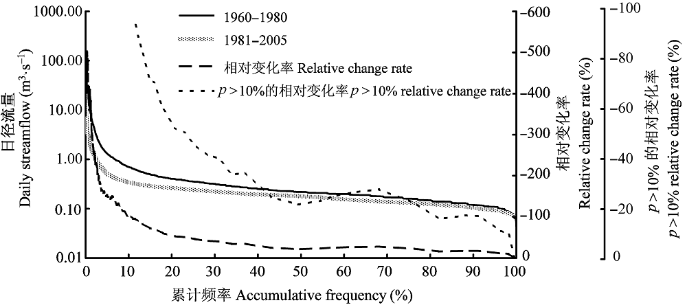
图4 基准段和变化段日径流量的累计频率曲线(用对数曲线表示)。
Fig. 4 Accumulated frequency distribution curve of baseline period and changed period (expressed as logarithmic curve).
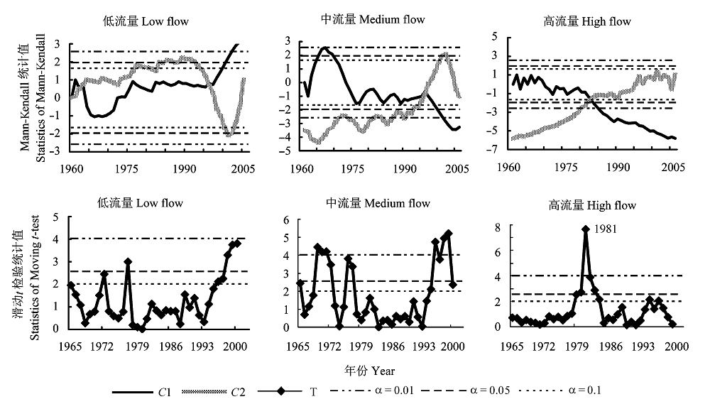
图5 1960-2005年清水河流域不同流量径流趋势。 C1、C2、T、α同图3。
Fig. 5 Trend of different flow of annual streamflow in Qingshui River watershed from 1960 to 2005. C1, C2, T, α see Fig. 3.
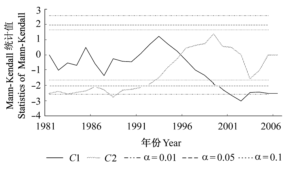
图6 1981-2005年径流的变化趋势。 C1、C2、T、α同图3。
Fig. 6 Trend of annual streamflow from 1981 to 2005. C1, C2, T, α see Fig. 3.
| [1] | Afifi AA, Azen SP (1972). Statistical Analysis: A Computer Oriented Approach. Academic Press, New York. |
| [2] | Chen LQ (陈利群), Liu CM (刘昌明), Yang C (杨聪), Hao FH (郝芳华) (2006). Baseflow estimation of the source regions of the Yellow River. Geographical Research (地理研究), 25, 659-665. (in Chinese with English abstract) |
| [3] | Cong ZT, Yang DW, Gao B, Yang HB, Hu HP (2009). Hydrological trend analysis in the Yellow River basin using a distributed hydrological model. Water Resources Research, 45, W00A13, doi: 10.1029/2008WR006852. |
| [4] | Fu CB (符淙斌), Wang Q (王强) (1992). The definition and detection of the abrupt climate change. Scientia Atmosphere Sinica (大气科学), 16, 482-492, 366. (in Chinese with English abstract) |
| [5] | Goossens CH, Berger A (1986). Annual and seasonal climatic variations over the Northern Hemisphere and Europe during the last century. Annales Geophysicae, 4, 385-400. |
| [6] | Hamon WR (1963). Computation of direct runoff amounts from storm rainfall. International Association of Scientific Hydrology Publication, 63, 52-62. |
| [7] | Kendall MG (1955). Rank Correlation Methods. Griffin, London. |
| [8] | Li LJ, Zhang L, Wang H, Wang J, Yang JW, Jiang DJ, Li JY, Qin DY (2007). Assessing the impact of climate variability and human activities on streamflow from the Wuding River basin in China. Hydrological Processes, 25, 3485-3491. |
| [9] | Liu XQ (刘晓清), Zhao JB (赵景波), Yu XF (于学峰) (2006). Study on the climatic warming-drying trend in the Loess Plateau and the countermeasures. Arid Zone Research (干旱区研究), 23, 627-631. (in Chinese with English abstract) |
| [10] | Mann HB (1945). Non-parametric test against trend. Econometrica, 13, 245-259. |
| [11] | McCulloch JG, Robinson M (1993). History of forest hydrology. Journal of Hydrology, 150, 189-216. |
| [12] | McVicar TR, Li LT, van Niel TG, Zhang L, Li R, Yang QK, Zhang XP, Mu XM, Wen ZM, Liu WZ, Zhao YA, Liu ZH, Gao P (2007). Developing a decision support tool for China’s re-vegetation program: simulating regional impacts of afforestation on average annual streamflow in the Loess Plateau. Forest Ecology and Management, 251, 65-81. |
| [13] | Milly PCD, Dunne KA (2002). Macroscale water fluxes. 2. Water and energy supply control of their interannual variability. Water Resources Research, 38, 1206. |
| [14] | Mu XM, Zhang L, McVicar TR, Chille BS, Gao P (2007). Analysis of the impact of conservation measures on streamflow regime in catchments of the Loess Plateau, China. Hydrological Processes, 21, 2124-2134. |
| [15] | Ran DC (冉大川), Luo QH (罗全华), Liu B (刘斌), Wang H (王宏) (2004). Effect of soil-retaining dams on flood and sediment reduction in middle reaches of Yellow River. Journal of Hydraulic Engineering (水利学报), 5, 7-14. (in Chinese with English abstract) |
| [16] | Rui XF (芮孝芳) (2004). Hydrology Principle (水文学原理). China Water Power Press, Beijing. (in Chinese) |
| [17] | Tang LX (唐丽霞) (2009). Effects of Landuse/Climate Variability on the Runoff and Sediment in Qingshuihe Watershed on the Loess Plateau, West Shanxi Province, China (黄土高原清水河流域土地利用/气候变化对径流泥沙的影响). PhD dissertation, Beijing Forestry University, Beijing. 98. (in Chinese) |
| [18] | Vogel RM, Fennessey NM (1994). Flow-duration curves. I. New interpretation and confidence intervals. Journal of Water Resources Planning and Management, 120, 485-504. |
| [19] | Wang SP (王盛萍) (2007). Eco-Hydrological Response of a Small Watershed to Landuse Change and Climate Variation (典型小流域土地利用与气候变化的生态水文响应研究). PhD dissertation, Beijing Forestry University, Beijing. 37-38. (in Chinese) |
| [20] | Xu JH (徐建华), Wu FQ (吴发启) (2005). The Runoff and Sediment Yield Mechanism on Loess Plateau and the Influence Mechanism on Water and Sediment by Using Water Conservation Measures (黄土高原产流产沙机制及水土保持措施对水资源和泥沙影响的机理研究). Yellow River Water Conservancy Press, Zhengzhou. (in Chinese) |
| [21] | Xu ZX, Li JY, Liu CM (2007). Long-term trend analysis for major climate variables in the Yellow River basin. Hydrological Procesess, 21, 1935-1948. |
| [22] | Xu ZX (徐宗学), Sui CH (隋彩虹) (2005). Long-term trend of temperature in the Yellow River basin. Meteorological Monthly (气象), 31, 7-10. (in Chinese with English abstract) |
| [23] | Yan ZW (严中伟), Ji JJ (季劲钧), Ye DZ (叶笃正) (1990). Analysis of the process of 1960s northern hemispheric summer climatic jump―Change of precipitation and temperature. Science in China, Series B (中国科学(B辑)) 20, 97-103. (in Chinese) |
| [24] | Yang YX (杨雨行), Han XC (韩熙春) (1991). A report of the affect on flow and sediment by the development of forests in clear water watershed in Jixian County, Shanxi Province. Journal of Beijing Forestry University (北京林业大学学报), 13, 59-67. (in Chinese with English abstract) |
| [25] | Yao YB (姚玉璧), Wang YR (王毅荣), Li YH (李耀辉), Zhang XY (张秀云) (2005). Climate warming and drying and its environmental effects in the Loess Plateau. Resources Science (资源科学), 27, 146-152. (in Chinese with English abstract) |
| [26] | Zhang L, Dawes WR, Walker GR (2001). Response of mean annual evapotranspiration to vegetation changes at catchment scale. Water Resources Research, 37, 701-708. |
| [27] | Zhang JY (张建云), Wang GQ (王国庆) (2007). The Research of the Influence on the Climate Change to Hydrology Water Resources (气候变化对水文水资源影响研究). Science Press, Beijing. 182-205. (in Chinese) |
| [28] | Zhang XP, Zhang L, McVicar TR, Tom G, van Niel TG, Li LT, Li R, Yang QK, Wei L (2008a). Modeling the impact of afforestation on average annual streamflow in the Loess Plateau, China. Hydrological Processes, 22, 1996-2004. |
| [29] |
Zhang XP, Zhang L, Zhao J, Rustomji P, Hairsine P (2008b). Responses of streamflow to changes in climate and land use/cover in the Loess Plateau, China. Water Resources Research, 44, W00A07, doi: 10.1029/2007WR006711.
DOI URL PMID |
| [30] | Zhang ZQ, Wang SP, Sun G, McNulty SG, Zhang HY, Li JL, Zhang ML, Klaghofer E, Strauss P (2008c). Evaluation of the MIKESHE model for application in the Loess Plateau, China. Journal of the American Water Resources Association, 44, 1108-1120. |
| [31] | Zhou XH (周晓红), Zhao JB (赵景波) (2005). Climatic change and vegetation restoration on the Loess Plateau. Arid Zone Research (干旱区研究), 23, 116-119. (in Chinese with English abstract) |
| [1] | 张智洋 赵颖慧 甄贞. 1986-2022年松花江流域陆地生态系统碳储量动态监测[J]. 植物生态学报, 2024, 48(预发表): 0-0. |
| [2] | 陈以恒 玉素甫江·如素力 阿卜杜热合曼·吾斯曼. 2001-2020年天山新疆段草地植被覆盖度时空变化及驱动因素分析[J]. 植物生态学报, 2024, 48(5): 561-576. |
| [3] | 张计深, 史新杰, 刘宇诺, 吴阳, 彭守璋. 气候变化下中国潜在自然植被生态系统碳储量动态[J]. 植物生态学报, 2024, 48(4): 428-444. |
| [4] | 臧妙涵, 王传宽, 梁逸娴, 刘逸潇, 上官虹玉, 全先奎. 基于纬度移栽的落叶松叶、枝、根生态化学计量特征对气候变暖的响应[J]. 植物生态学报, 2024, 48(4): 469-482. |
| [5] | 梁逸娴, 王传宽, 臧妙涵, 上官虹玉, 刘逸潇, 全先奎. 落叶松径向生长和生物量分配对气候变暖的响应[J]. 植物生态学报, 2024, 48(4): 459-468. |
| [6] | 吴茹茹, 刘美珍, 谷仙, 常馨月, 郭立月, 蒋高明, 祁如意. 气候变化对巨柏适宜生境分布的潜在影响和预测[J]. 植物生态学报, 2024, 48(4): 445-458. |
| [7] | 杨宇萌, 来全, 刘心怡. 气候变化和人类活动对内蒙古植被总初级生产力的定量影响[J]. 植物生态学报, 2024, 48(3): 306-316. |
| [8] | 张启, 程雪寒, 王树芝. 北京西山老龄树记载的森林干扰历史[J]. 植物生态学报, 2024, 48(3): 341-348. |
| [9] | 任培鑫, 李鹏, 彭长辉, 周晓路, 杨铭霞. 洞庭湖流域植被光合物候的时空变化及其对气候变化的响应[J]. 植物生态学报, 2023, 47(3): 319-330. |
| [10] | 李杰, 郝珉辉, 范春雨, 张春雨, 赵秀海. 东北温带森林树种和功能多样性对生态系统多功能性的影响[J]. 植物生态学报, 2023, 47(11): 1507-1522. |
| [11] | 魏瑶, 马志远, 周佳颖, 张振华. 模拟增温改变青藏高原植物繁殖物候及植株高度[J]. 植物生态学报, 2022, 46(9): 995-1004. |
| [12] | 党宏忠, 张学利, 韩辉, 石长春, 葛玉祥, 马全林, 陈帅, 刘春颖. 樟子松固沙林林水关系研究进展及对营林实践的指导[J]. 植物生态学报, 2022, 46(9): 971-983. |
| [13] | 李肖, PIALUANG Bounthong, 康文辉, 冀晓东, 张海江, 薛治国, 张志强. 近几十年来冀西北山地白桦次生林径向生长对气候变化的响应[J]. 植物生态学报, 2022, 46(8): 919-931. |
| [14] | 苏启陶, 杜志喧, 周兵, 廖永辉, 王呈呈, 肖宜安. 牯岭凤仙花及其传粉昆虫在中国的潜在分布区域分析[J]. 植物生态学报, 2022, 46(7): 785-796. |
| [15] | 胡潇飞, 魏临风, 程琦, 吴星麒, 倪健. 青藏高原地区气候图解数据集[J]. 植物生态学报, 2022, 46(4): 484-492. |
| 阅读次数 | ||||||
|
全文 |
|
|||||
|
摘要 |
|
|||||
Copyright © 2026 版权所有 《植物生态学报》编辑部
地址: 北京香山南辛村20号, 邮编: 100093
Tel.: 010-62836134, 62836138; Fax: 010-82599431; E-mail: apes@ibcas.ac.cn, cjpe@ibcas.ac.cn
备案号: 京ICP备16067583号-19
![]()