
植物生态学报 ›› 2016, Vol. 40 ›› Issue (9): 902-911.DOI: 10.17521/cjpe.2016.0029 cstr: 32100.14.cjpe.2016.0029
所属专题: 青藏高原植物生态学:生态系统生态学; 生态系统碳水能量通量
周文昌1,2, 崔丽娟1,*( ), 王义飞1, 李伟1, 康晓明1
收稿日期:2016-01-17
接受日期:2016-05-09
出版日期:2016-09-10
发布日期:2016-09-29
Wen-Chang ZHOU1,2, Li-Juan CUI1,*(), Yi-Fei WANG1, Wei LI1, Xiao-Ming KANG1
Received:2016-01-17
Accepted:2016-05-09
Online:2016-09-10
Published:2016-09-29
摘要:
若尔盖高原是我国泥炭沼泽湿地的主要分布区、青藏高原的主要甲烷(CH4)排放中心。为了研究湿地微地貌环境对高原湿地CH4排放通量的影响, 2014年5-10月, 采用静态箱和快速温室气体分析仪原位测量若尔盖高原湖滨湿地3种泥炭沼泽5种微地貌环境下的CH4排放通量特征。结果表明: (1)常年性淹水泥炭湿地洼地(P-hollow)和草丘(P-hummock)生长季平均CH4排放通量为68.48和40.32 mg·m-2·h-1, 季节性淹水的泥炭湿地洼地(S-hollow)和草丘(S-hummock)平均CH4排放通量为2.38和0.63 mg·m-2·h-1, 而无淹水平坦地(Lawn)平均CH4排放通量为3.68 mg·m-2·h-1; (2)湿地5种微地貌区CH4排放通量为(23.10 ± 30.28) mg·m-2·h-1 (平均值±标准偏差)), 变异系数为131%。分析显示这5种微地貌区CH4排放通量的平均值与其水位深度平均值存在显著的线性正相关关系(R2 = 0.919, p < 0.01), 表明水位深度是控制湿地微地貌区CH4排放通量空间变化的主要因子; (3) P-hummock、P-hollow和S-hummock的CH4排放通量存在显著的季节变化, Lawn和S-hollow无明显的季节性变化, 但5种微地貌区在夏季或秋季均观测到CH4排放通量峰值, 其影响因子可能与水位深度、土壤温度和凋落物输入密切相关; (4) P-hollow可能时常发生冒泡式CH4排放, 这可能导致过去低估了若尔盖高原湿地的CH4排放量。
周文昌, 崔丽娟, 王义飞, 李伟, 康晓明. 若尔盖高原湿地不同微地貌区甲烷排放通量特征. 植物生态学报, 2016, 40(9): 902-911. DOI: 10.17521/cjpe.2016.0029
Wen-Chang ZHOU, Li-Juan CUI, Yi-Fei WANG, Wei LI, Xiao-Ming KANG. Characteristics of methane emission fluxes in the Zoigê Plateau wetland on microtopography. Chinese Journal of Plant Ecology, 2016, 40(9): 902-911. DOI: 10.17521/cjpe.2016.0029
| 样点 Plot | pH (0-10 cm depth) | 土壤有机碳含量 Soil organic carbon content (0-30 cm depth) (g·kg-1) | 土壤容重 Bulk density (0-30 cm depth) (g·cm-3) | 总氮 Total nitrogen (0-10 cm depth) (g·kg-1) | 地上生物量 Aboveground biomass (g·m-2) |
|---|---|---|---|---|---|
| P-hummock | 7.6 ± 0.1 | 210.38 ± 47.29 | 0.29 ± 0.09 | 15.20 ± 3.50 | 127.16 ± 8.11 |
| P-hollow | 279.34 ± 35.54 | ||||
| Lawn | 7.5 ± 0.3 | 143.21 ± 10.03 | 0.52 ± 0.08 | 18.05 ± 0.00 | 142.28 ± 95.61 |
| S-hummock | 7.5 ± 0.2 | 151.74 ± 74.15 | 0.40 ± 0.16 | 8.91 ± 3.85 | 189.74 ± 72.79 |
| S-hollow | 194.01 ± 50.07 |
表1 若尔盖高原湿地5种微地貌土壤理化性质(平均值±标准偏差)
Table 1 Soil physical and chemical properties from the Zoigê Plateau wetland on five microtopography (mean ± SD)
| 样点 Plot | pH (0-10 cm depth) | 土壤有机碳含量 Soil organic carbon content (0-30 cm depth) (g·kg-1) | 土壤容重 Bulk density (0-30 cm depth) (g·cm-3) | 总氮 Total nitrogen (0-10 cm depth) (g·kg-1) | 地上生物量 Aboveground biomass (g·m-2) |
|---|---|---|---|---|---|
| P-hummock | 7.6 ± 0.1 | 210.38 ± 47.29 | 0.29 ± 0.09 | 15.20 ± 3.50 | 127.16 ± 8.11 |
| P-hollow | 279.34 ± 35.54 | ||||
| Lawn | 7.5 ± 0.3 | 143.21 ± 10.03 | 0.52 ± 0.08 | 18.05 ± 0.00 | 142.28 ± 95.61 |
| S-hummock | 7.5 ± 0.2 | 151.74 ± 74.15 | 0.40 ± 0.16 | 8.91 ± 3.85 | 189.74 ± 72.79 |
| S-hollow | 194.01 ± 50.07 |
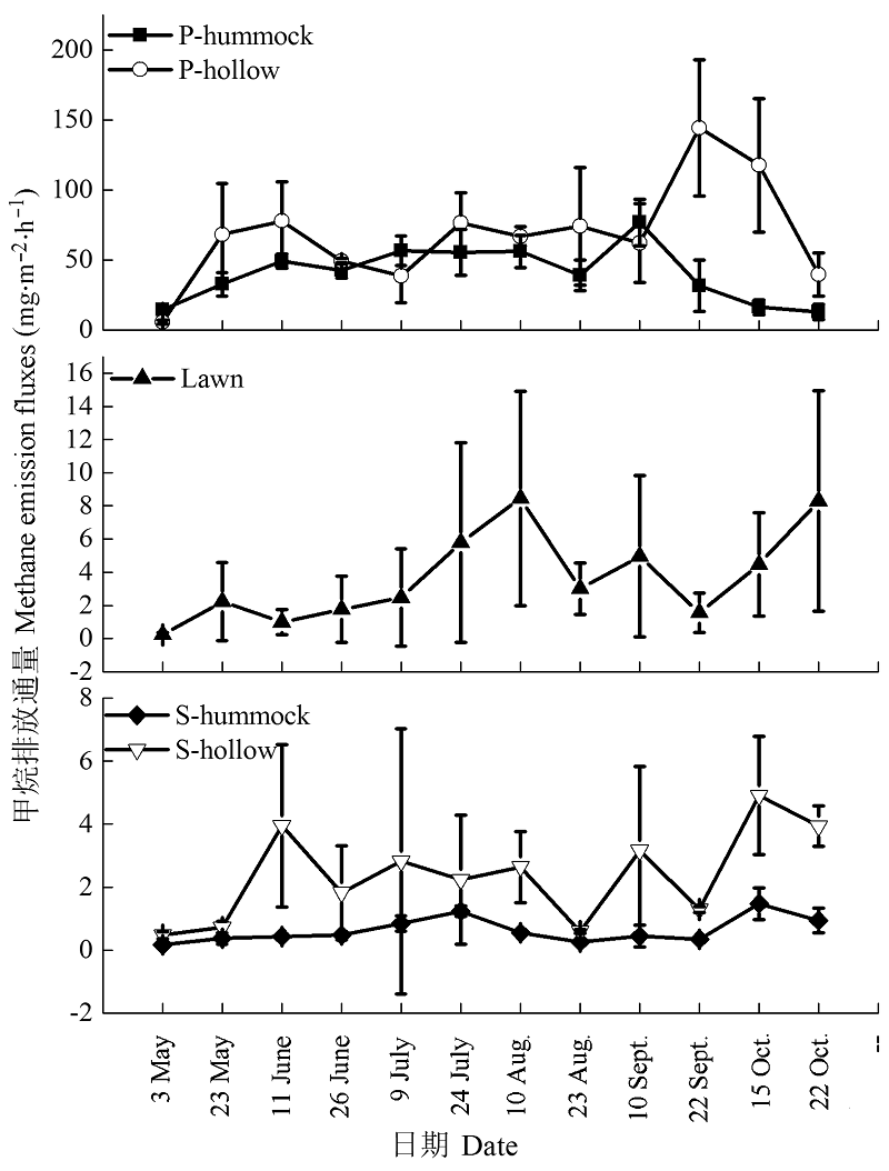
图1 若尔盖高原湿地5种微地貌区2014年CH4排放通量季节性变化(平均值±标准偏差)。Lawn, 常年性淹水与季节性淹水点之间的过渡带平坦地; P-hollow, 常年性淹水洼地; P-hummock, 常年性淹水草丘; S-hollow, 季节性淹水洼地; S-hummock, 季节性淹水草丘。
Fig. 1 Seasonal variations of CH4 emission fluxes from Zoigê Plateau wetland on five microtopography in 2014 (mean ± SD). Lawn, transitional zones between permanently flooded and seasonally flooded sites; P-hollow, permanently flooded hollow; P-hummock, permanently flooded hummock; S-hollow, seasonally flooded hollow; S-hummock, seasonally flooded hummock.
| 样点 Plot | 回归方程 Regression equation | 变量 Variable | 变量范围 Variable range | R2 | p | n |
|---|---|---|---|---|---|---|
| CH4排放通量平均值 Mean CH4 emission fluxes | y = 1.07x + 32.79 | WTD | -39.7-29.5 cm | 0.919 | 0.006 | 5 |
| P-hummock | y = 5.07x - 10.38 | T5 | 5.6-17.9 ℃ | 0.747 | 0.000 | 12 |
| y = 4.60x - 5.00 | T10 | 4.0-14.6 ℃ | 0.694 | 0.012 | 12 | |
| y = 4.21x - 2.08 | T15 | 3.2-14.5 ℃ | 0.698 | 0.012 | 12 | |
| y = 4.12x - 1.49 | T20 | 3.0-15.0 ℃ | 0.737 | 0.006 | 12 | |
| y = 3.63x + 5.93 | T30 | 1.7-15.1 ℃ | 0.670 | 0.017 | 12 | |
| S-hummock | y = 0.07x - 0.27 | T10 | 4.0-14.6 ℃ | 0.407 | 0.028 | 10 |
| y = 0.07x - 0.23 | T15 | 3.2-14.5 ℃ | 0.448 | 0.020 | 10 | |
| y = 0.06x - 0.19 | T20 | 3.0-15.0 ℃ | 0.429 | 0.024 | 10 | |
| y = 0.05x - 0.07 | T30 | 1.7-15.1 ℃ | 0.346 | 0.043 | 10 |
表2 CH4排放通量与土壤温度和水位深度的相关性
Table 2 Correlation between CH4 emission fluxes and soil temperature or water table depth
| 样点 Plot | 回归方程 Regression equation | 变量 Variable | 变量范围 Variable range | R2 | p | n |
|---|---|---|---|---|---|---|
| CH4排放通量平均值 Mean CH4 emission fluxes | y = 1.07x + 32.79 | WTD | -39.7-29.5 cm | 0.919 | 0.006 | 5 |
| P-hummock | y = 5.07x - 10.38 | T5 | 5.6-17.9 ℃ | 0.747 | 0.000 | 12 |
| y = 4.60x - 5.00 | T10 | 4.0-14.6 ℃ | 0.694 | 0.012 | 12 | |
| y = 4.21x - 2.08 | T15 | 3.2-14.5 ℃ | 0.698 | 0.012 | 12 | |
| y = 4.12x - 1.49 | T20 | 3.0-15.0 ℃ | 0.737 | 0.006 | 12 | |
| y = 3.63x + 5.93 | T30 | 1.7-15.1 ℃ | 0.670 | 0.017 | 12 | |
| S-hummock | y = 0.07x - 0.27 | T10 | 4.0-14.6 ℃ | 0.407 | 0.028 | 10 |
| y = 0.07x - 0.23 | T15 | 3.2-14.5 ℃ | 0.448 | 0.020 | 10 | |
| y = 0.06x - 0.19 | T20 | 3.0-15.0 ℃ | 0.429 | 0.024 | 10 | |
| y = 0.05x - 0.07 | T30 | 1.7-15.1 ℃ | 0.346 | 0.043 | 10 |
| 位点 Location | 主要植被 Main vegetation | 水位深度 water table depth (cm) | CH4排放通量平均值 Mean CH4 emission fluxes (mg·m-2·h-1) | 范围 Range (mg·m-2·h-1) | 研究时间 Study period | 参考文献 Reference |
|---|---|---|---|---|---|---|
| 若尔盖高原若尔盖县 Zoigê County of Zoigê Plateau | 23.10 ± 30.28 | 0.17-144.43 | May to Oct. 2014 | 本研究 This study | ||
| P-hollow | 小眼子菜和狸藻 Potamogeton pusillus and Utricularia vulgaris | 29.5 | 68.48 | 5.78-144.43 | 本研究 This study | |
| P-hummock | 木里薹草 Carex muliensis | 7.5 | 40.32 | 12.93-76.86 | 本研究 This study | |
| Lawn | 西藏嵩草和花葶驴蹄草 Kobresia tibetica and Caltha scaposa | -21.6 | 3.68 | 0.23-8.45 | 本研究 This study | |
| S-hollow | 木里薹草 Carex muliensis | -21.1 | 2.38 | 0.48-4.91 | 本研究 This study | |
| S-hummock | 西藏嵩草 Kobresia tibetica | -39.7 | 0.63 | 0.17-1.48 | 本研究 This study | |
| 若尔盖高原红原县 Hongyuan County of Zoigê Plateau | 乌拉草 Carex meyeriana | ND | 4.51 | 0.36-10.04 | May to Sept. 2001 | Wang et al., 2002 |
| 若尔盖高原红原县 Hongyuan County of Zoigê Plateau | 木里薹草 Carex muliensis | ND | 2.87 | 0.51-8.21 | May to Sept. 2001 | Wang et al., 2002 |
| 若尔盖高原红原县 Hongyuan County of Zoigê Plateau | 乌拉草 Carex meyeriana | ND | 3.24 | 0.86-8.93 | May to Oct. 2002 | Ding et al., 2004 |
| 若尔盖高原红原县 Hongyuan County of Zoigê Plateau | 木里薹草 Carex muliensis | ND | 1.24 | 0.16-5.75 | May to Oct. 2002 | Ding et al., 2004 |
| 若尔盖高原红原县 Hongyuan County of Zoigê Plateau | 木里薹草和乌拉草 Carex muliensis and Carex meyeriana | ND | 2.43 | 0.02-12.01 | May to Oct. 2003 | Wang, 2010 |
| 若尔盖高原若尔盖县 Zoigê County of Zoigê Plateau | 西藏嵩草和木里薹草 Kobresia tibetica and Carex muliensis | -18.36-10.66 | 14.45 | 0.17-86.78 | June to Sept. 2005 | Chen et al., 2008 |
| 若尔盖高原若尔盖县 Zoigê County of Zoigê Plateau | 木里薹草 Carex muliensis | -53.94- -4.74 | 9.83 | 0.06-39.5 | June to Sept. 2009 | Li et al., 2011 |
| 青藏高原 Qinghai-Xizang Plateau | 藏北嵩草和签草 Kobresia littledalei and Carex doniana | ND | 2.80 ± 0.80 | ND | July to Aug. 1996 | Wei et al., 2015 |
| 青藏高原 Qinghai-Xizang Plateau | 毛柄水毛茛 Batrachium trichophyllum | ND | 0.27 | -0.81-2.64 | April to Sept. 1997 | Jin et al., 1999 |
| 青藏高原 Qinghai-Xizang Plateau | 杉叶藻 Hippuris vulgaris | 10-120 | 1.46 | -0.24-7.85 | April to Sept. 1997 | Jin et al., 1999 |
| 青藏高原 Qinghai-Xizang Plateau | 薹草属 Carex allivescers | 12 | 8.19 | 1.91-10.58 | July to Sept. 2002 | Hirota et al., 2004 |
| 青藏高原 Qinghai-Xizang Plateau | 帕米尔薹草 Carex pamirensis | 0.2 | 5 | 2.88-6.91 | May to Sept. 2012 | Song et al., 2015 |
| 青藏高原 Qinghai-Xizang Plateau | 帕米尔薹草 Carex pamirensis | 0.6 | 6.11 | 4.61-13.25 | May to Sept. 2013 | Song et al., 2015 |
| 美国科罗拉多州弗兰特山脉 Colorado Front Range, USA | 薹草 Carex scopulorum | ND | 0.35 | 0.05-1.10 | June to Sept. 1992 | West et al., 1999 |
| 北美洲落基山脉 Rocky Mountains, North America | 薹草 Carex aquatilis | ND | 11.45 | 0.04-20.41 | May to Oct.1996 | Wickland et al., 1999 |
表3 不同地区高原泥炭地生长季CH4排放通量比较
Table 3 Comparison of CH4 emission fluxes in various plateau peatlands during the growing season
| 位点 Location | 主要植被 Main vegetation | 水位深度 water table depth (cm) | CH4排放通量平均值 Mean CH4 emission fluxes (mg·m-2·h-1) | 范围 Range (mg·m-2·h-1) | 研究时间 Study period | 参考文献 Reference |
|---|---|---|---|---|---|---|
| 若尔盖高原若尔盖县 Zoigê County of Zoigê Plateau | 23.10 ± 30.28 | 0.17-144.43 | May to Oct. 2014 | 本研究 This study | ||
| P-hollow | 小眼子菜和狸藻 Potamogeton pusillus and Utricularia vulgaris | 29.5 | 68.48 | 5.78-144.43 | 本研究 This study | |
| P-hummock | 木里薹草 Carex muliensis | 7.5 | 40.32 | 12.93-76.86 | 本研究 This study | |
| Lawn | 西藏嵩草和花葶驴蹄草 Kobresia tibetica and Caltha scaposa | -21.6 | 3.68 | 0.23-8.45 | 本研究 This study | |
| S-hollow | 木里薹草 Carex muliensis | -21.1 | 2.38 | 0.48-4.91 | 本研究 This study | |
| S-hummock | 西藏嵩草 Kobresia tibetica | -39.7 | 0.63 | 0.17-1.48 | 本研究 This study | |
| 若尔盖高原红原县 Hongyuan County of Zoigê Plateau | 乌拉草 Carex meyeriana | ND | 4.51 | 0.36-10.04 | May to Sept. 2001 | Wang et al., 2002 |
| 若尔盖高原红原县 Hongyuan County of Zoigê Plateau | 木里薹草 Carex muliensis | ND | 2.87 | 0.51-8.21 | May to Sept. 2001 | Wang et al., 2002 |
| 若尔盖高原红原县 Hongyuan County of Zoigê Plateau | 乌拉草 Carex meyeriana | ND | 3.24 | 0.86-8.93 | May to Oct. 2002 | Ding et al., 2004 |
| 若尔盖高原红原县 Hongyuan County of Zoigê Plateau | 木里薹草 Carex muliensis | ND | 1.24 | 0.16-5.75 | May to Oct. 2002 | Ding et al., 2004 |
| 若尔盖高原红原县 Hongyuan County of Zoigê Plateau | 木里薹草和乌拉草 Carex muliensis and Carex meyeriana | ND | 2.43 | 0.02-12.01 | May to Oct. 2003 | Wang, 2010 |
| 若尔盖高原若尔盖县 Zoigê County of Zoigê Plateau | 西藏嵩草和木里薹草 Kobresia tibetica and Carex muliensis | -18.36-10.66 | 14.45 | 0.17-86.78 | June to Sept. 2005 | Chen et al., 2008 |
| 若尔盖高原若尔盖县 Zoigê County of Zoigê Plateau | 木里薹草 Carex muliensis | -53.94- -4.74 | 9.83 | 0.06-39.5 | June to Sept. 2009 | Li et al., 2011 |
| 青藏高原 Qinghai-Xizang Plateau | 藏北嵩草和签草 Kobresia littledalei and Carex doniana | ND | 2.80 ± 0.80 | ND | July to Aug. 1996 | Wei et al., 2015 |
| 青藏高原 Qinghai-Xizang Plateau | 毛柄水毛茛 Batrachium trichophyllum | ND | 0.27 | -0.81-2.64 | April to Sept. 1997 | Jin et al., 1999 |
| 青藏高原 Qinghai-Xizang Plateau | 杉叶藻 Hippuris vulgaris | 10-120 | 1.46 | -0.24-7.85 | April to Sept. 1997 | Jin et al., 1999 |
| 青藏高原 Qinghai-Xizang Plateau | 薹草属 Carex allivescers | 12 | 8.19 | 1.91-10.58 | July to Sept. 2002 | Hirota et al., 2004 |
| 青藏高原 Qinghai-Xizang Plateau | 帕米尔薹草 Carex pamirensis | 0.2 | 5 | 2.88-6.91 | May to Sept. 2012 | Song et al., 2015 |
| 青藏高原 Qinghai-Xizang Plateau | 帕米尔薹草 Carex pamirensis | 0.6 | 6.11 | 4.61-13.25 | May to Sept. 2013 | Song et al., 2015 |
| 美国科罗拉多州弗兰特山脉 Colorado Front Range, USA | 薹草 Carex scopulorum | ND | 0.35 | 0.05-1.10 | June to Sept. 1992 | West et al., 1999 |
| 北美洲落基山脉 Rocky Mountains, North America | 薹草 Carex aquatilis | ND | 11.45 | 0.04-20.41 | May to Oct.1996 | Wickland et al., 1999 |
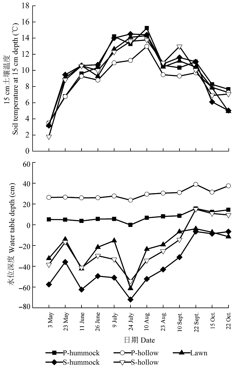
图2 2014年若尔盖高原湿地5种微地貌区15 cm土壤温度和水位深度。Lawn, 常年性淹水与季节性淹水点之间的过渡带平坦地; P-hollow, 常年性淹水洼地; P-hummock, 常年性淹水草丘; S-hollow, 季节性淹水洼地; S-hummock, 季节性淹水草丘。
Fig. 2 Soil temperature at 15 cm depth and water table depth from the Zoigê Plateau wetland on five microtopography in 2104. Lawn, transitional zones between permanently flooded and seasonally flooded sites; P-hollow, permanently flooded hollow; P-hummock, permanently flooded hummock; S-hollow, seasonally flooded hollow; S-hummock, seasonally flooded hummock.
| 1 | Casper P, Maberly SC, Hall GH, Finlay BJ (2000). Fluxes of methane and carbon dioxide from a small productive lake to the atmosphere.Biogeochemistry, 49, 1-19. |
| 2 | Chen H, Yao SP, Wu N, Wang YF, Luo P, Tian JQ, Gao YH, Sun G (2008). Determinants influencing seasonal variations of methane emissions from alpine wetlands in Zoigê Plateau and their implications. Journal of Geophysical Research, 113(D12), doi:10.1029/2006JD008072. |
| 3 | Chen YH, Prinn RG (2006). Estimation of atmospheric methane emissions between 1996 and 2001 using a three- dimensional global chemical transport model. Journal of Geophysical Research, 111(D10), doi:10.1029/2005JD- 006058. |
| 4 | Clymo RS, Pearce DME, Conrad R (1995). Methane and carbon dioxide production in, transport through, and efflux from a peatland [and discussion].Philosophical Transactions of the Royal Society A: Mathematical, Physical and Engineering Sciences, 351, 249-259. |
| 5 | Deng ZH, Zhang XW, Gao JJ, Gao JQ (2015). Effects of soil moisture and litter on CH4 emission from peat in Zoigê wetlands.Journal of Ecology and Rural Environment, 31, 548-552. (in Chinese with English abstract)[邓昭衡, 张雪雯, 高居娟, 高俊琴 (2015). 水分及凋落物对若尔盖泥炭土CH4排放的影响. 生态与农村环境学报, 31, 548-552.] |
| 6 | Ding WX, Cai ZC (2002). Methane emission from mires and its influencing factors.Scientia Geographica Sinica, 22, 619-625. (in Chinese with English abstract)[丁维新, 蔡祖聪 (2002). 沼泽甲烷排放及其主要影响因素. 地理科学, 22, 619-625.] |
| 7 | Ding WX, Cai ZC, Tsuruta H, Li XP (2003). Key factors affecting spatial variation of methane emissions from freshwater marshes.Chemosphere, 51, 167-173. |
| 8 | Ding WX, Cai ZC, Wang DX (2004). Preliminary budget of methane emissions from natural wetlands in China.Atmospheric Environment, 38, 751-759. |
| 9 | Dise NB (1993). Methane emission from Minnesota peatlands: Spatial and seasonal variability.Global Biogeochemical Cycles, 7, 123-142. |
| 10 | Glagolev M, Kleptsova I, Filippov I, Maksyutov S, Machida T (2011). Regional methane emission from West Siberia mire landscapes.Environmental Research Letters, 6, doi:10.1088/1748-9326/6/4/045214. |
| 11 | Glagolev MV, Shnyrev NA (2008). Methane emission from mires of Tomsk oblast in the summer and fall and the problem of spatial and temporal extrapolation of the obtained data.Moscow University Soil Science Bulletin, 63(2), 67-80. |
| 12 | Hirota M, Tang YH, Hu QW, Hirata S, Kato T, Mo WH, Cao GM, Mariko S (2004). Methane emissions from different vegetation zones in a Qinghai-Tibetan Plateau wetland.Soil Biology & Biochemistry, 36, 737-748. |
| 13 | Huang PY, Yu HX, Chai LH, Chai FY, Zhang WF (2011). Methane emission flux of Zhalong Phragmites australis wetlands in growth season.Chinese Journal of Applied Ecology, 22, 1219-1224. (in Chinese with English abstract)[黄璞祎, 于洪贤, 柴龙会, 柴方营, 张万峰 (2011). 扎龙芦苇湿地生长季的甲烷排放通量. 应用生态学报, 22, 1219-1224.] |
| 14 | Huttunen JT, Nykänen H, Turunen J, Martikainen PJ (2003). Methane emissions from natural peatlands in the northern boreal zone in Finland, Fennoscandia.Atmospheric Environment, 37, 147-151. |
| 15 | Inubushi K, Otake S, Furukawa Y, Shibasaki N, Ali M, Itang AM, Tsuruta H (2005). Factors influencing methane emission from peat soils: Comparison of tropical and temperate wetlands.Nutrient Cycling in Agroecosystems, 71, 93-99. |
| 16 | IPCC (Intergovernmental Panel on Climate Change) (2013). Climate change 2013: The physical science basis. In: Stocker TF, Qin D, Plattner GK, Tignor M, Allen SK, Boschung J, Nauels A, Xia Y, Bex V, Midgley PM eds. Contribution of Working Group I to the Fifth Assessment Report of the Intergovernmental Panel on Climate Change. Cambridge University Press, Cambridge, UK. |
| 17 | Jin HJ, Wu J, Cheng GD, Nakano T, Sun GY (1999). Methane emissions from wetlands on the Qinghai-Tibet Plateau.Chinese Science Bulletin, 44, 2282-2286. |
| 18 | Kalyuzhnyi IL, Lavrov SA, Reshetnikov AI, Paramonova NN, Privalov VI (2009). Methane emission from the oligotrophic bog massif in the Northwestern Russia.Russian Meteorology and Hydrology, 34, 35-45. |
| 19 | Keller M, Stallard RF (1994). Methane emission by bubbling from Gatun Lake, Panama.Journal of Geophysical Research, 99(D4), 8307-8319. |
| 20 | Kirschke S, Bousquet P, Ciais P, Saunois M, Canadell JG, Dlugokencky EJ, Bergamaschi P, Bergmann D, Blake DR, Bruhwiler L, Cameron-Smith P, Castaldi S, Chevallier F, Feng L, Fraser A, Heimann M, Hodson EL, Houweling S, Josse B, Fraser PJ, Krummel PB, Lamarque JF, Langenfelds RL, Le Quéré C, Naik V, O’Doherty S, Palmer PI, Pison I, Plummer D, Poulter B, Prinn RG, Rigby M, Ringeval B, Santini M, Schmidt M, Shindell DT, Simpson IJ, Spahni R, Steele LP, Strode SA, Sudo K, Szopa S, van der Werf GR, Voulgarakis A, van Weele M, Weiss RF, Williams JE, Zeng G (2013). Three decades of global methane sources and sinks.Nature Geoscience, 6, 813-823. |
| 21 | Kutzbach L, Wagner D, Pfeiffer EM (2004). Effect of microrelief and vegetation on methane emission from wet polygonal tundra, Lena Delta, Northern Siberia.Biogeochemistry, 69, 341-362. |
| 22 | Lai DYF (2009). Methane dynamics in northern peatlands: A review.Pedosphere, 19, 409-421. |
| 23 | Le Mer J, Roger P (2001). Production, oxidation, emission and consumption of methane by soils: A review.European Journal of Soil Biology, 37, 25-50. |
| 24 | Li L, Lei GC, Gao JQ, Lu C, Zhou Y, Jia YF, Yang M, Suolang DEJ (2011). Effect of water table and soil water content on methane emission flux at Carex muliensis marshes in Zoigȇ Plateau.Wetland Science, 9(2), 173-178. (in Chinese with English abstract)[李丽, 雷光春, 高俊琴, 吕偲, 周延, 贾亦飞, 杨萌, 索郎夺尔基 (2011). 地下水位和土壤含水量对若尔盖木里薹草沼泽甲烷排放通量的影响. 湿地科学, 9(2), 173-178.] |
| 25 | Mastepanov M, Sigsgaard C, Dlugokencky EJ, Houweling S, Ström L, Tamstorf MP, Christensen TR (2008). Large tundra methane burst during onset of freezing.Nature, 456, 628-630. |
| 26 | McEwing KR, Fisher JP, Zona D (2015). Environmental and vegetation controls on the spatial variability of CH4 emission from wet-sedge and tussock tundra ecosystems in the Arctic.Plant and Soil, 388, 37-52. |
| 27 | Mikkelä C, Sundh I, Svensson BH, Nilsson M (1995). Diurnal variation in methane emission in relation to the water table, soil temperature, climate and vegetation cover in a Swedish acid mire.Biogeochemistry, 28, 93-114. |
| 28 | Moore TR, Heyes A, Roulet NT (1994). Methane emissions from wetlands, southern Hudson Bay lowland.Journal of Geophysical Research, 99(D1), 1455-1467. |
| 29 | Munir TM, Strack M (2014). Methane flux influenced by experimental water table drawdown and soil warming in a dry boreal continental bog.Ecosystems, 17, 1271-1285. |
| 30 | Rigby M, Prinn RG, Fraser PJ, Simmonds PG, Langenfelds RL, Huang J, Cunnold DM, Steele LP, Krummel PB, Weiss RF, O’Doherty S, Salameh PK, Wang HJ, Hart CM, Mühle J, Porter LW (2008). Renewed growth of atmospheric methane.Geophysical Research Letters, 35, doi:10. 1029/2008GL036037. |
| 31 | Song CC, Zhang LH, Wang YY, Zhao ZC (2006). Annual dynamics of CO2, CH4, N2O emissions from freshwater marshes and affected by nitrogen fertilization.Environmental Science, 7, 2369-2375. (in Chinese with English abstract)[宋长春, 张丽华, 王毅勇, 赵志春 (2006). 淡水沼泽湿地CO2、CH4和N2O排放通量年际变化及其对氮输入的响应. 环境科学, 27, 2369-2375.] |
| 32 | Song WM, Wang H, Wang GS, Chen LT, Jin ZN, Zhuang QL, He JS (2015). Methane emissions from an alpine wetland on the Tibetan Plateau: Neglected but vital contribution of the nongrowing season.Journal of Geophysical Research, 120,1475-1490. |
| 33 | Sun XX, Mu CC, Shi LY, Chen W, Liu X, Wu YX, Feng DJ (2009). Methane emission from forested swamps in Xiaoxing’an Mountains, northeastern China.Chinese Journal of Plant Ecology, 33, 535-545. (in Chinese with English abstract)[孙晓新, 牟长城, 石兰英, 程伟, 刘霞, 吴云霞, 冯登军 (2009). 小兴安岭森林沼泽甲烷排放及其影响因子. 植物生态学报, 33, 535-545.] |
| 34 | Sun XX, Mu CC, Song CC (2011). Seasonal and spatial variations of methane emissions from montane wetlands in Northeast China.Atmospheric Environment, 45, 1809-1816 |
| 35 | Tokida T, Miyazaki T, Mizoguchi M, Nagata O, Takakai F, Kagemoto A, Hatano R (2007). Falling atmospheric pressure as a trigger for methane ebullition from peatland.Global Biogeochemical Cycles, 21, doi:10.1029/2006- GB002790. |
| 36 | van Huissteden J, Maximov TC, Dolman AJ (2005). High methane flux from an arctic floodplain (Indigirka lowlands, eastern Siberia).Journal of Geophysical Research, 110, G02002, doi:10.1029/2005JG000010. |
| 37 | Waddington JM, Roulet NT (1996). Atmosphere-wetland carbon exchanges: Scale dependency of CO2 and CH4 exchange on the developmental topography of a peatland. Global Biogeochemical Cycles, 10, 233-245. |
| 38 | Walter KM, Zimov SA, Chanton JP, Verbyla D, Chapin FS (2006). Methane bubbling from Siberian thaw lakes as a positive feedback to climate warming.Nature, 443, 71-75. |
| 39 | Wang CK, Lu XG, Zhou HR, Cai ZC, Luo Y (2004). Studies on methane oxidation by bog soils in Zoigê Plateau.China Environmental Science, 24, 646-649. (in Chinese with English abstract)[王长科, 吕宪国, 周华荣, 蔡祖聪, 罗勇 (2004). 若尔盖高原沼泽土壤氧化甲烷的研究. 中国环境科学, 24, 646-649.] |
| 40 | Wang DX (2010). Emission fluxes of carbon dioxide, methane and nitrous oxide from peat marsh in Zoigê Plateau.Wetland Science, 8(3), 220-224. (in Chinese with English abstract)[王德宣 (2010). 若尔盖高原泥炭沼泽二氧化碳、甲烷和氧化亚氮排放通量研究. 湿地科学, 8(3), 220-224.] |
| 41 | Wang DX, Lu XG, Ding WX, Cai ZC, Gao JF, Yang FM (2002). Methane emission from marshes in Zoigê Plateau.Advance in Earth Sciences, 17, 877-880. (in Chinese with English abstract)[王德宣, 吕宪国, 丁维新, 蔡祖聪, 高景福, 杨福明 (2002). 若尔盖高原沼泽湿地CH4排放研究. 地球科学进展, 17, 877-880.] |
| 42 | Wang ZP, Duan Y, Yang JR, Chen QS, Han XG (2003). Spatial distribution of potential CH4 oxidation and production in Zoigê marsh of Qinghai-Tibet Plateau.Acta Phytoecologica Sinica, 27, 786-791. (in Chinese with English abstract)[王智平, 段毅, 杨居荣, 陈全胜, 韩兴国 (2003). 青藏高原若尔盖沼泽潜在CH4氧化与生成的分布特征. 植物生态学报, 27, 786-791.] |
| 43 | Wei D, Xu R, Tarchen T, Dai DX, Wang YS, Wang YH (2015). Revisiting the role of CH4 emissions from alpine wetlands on the Tibetan Plateau: Evidence from two in situ measurements at 4758 and 4320 m above sea level.Journal of Geophysical Research, 120, 1741-1750. |
| 44 | West AE, Brooks PD, Fisk MC, Smith LK, Holland EA, Jaeger CH, Babcock S, Lai RS, Schmidt SK (1999). Landscape patterns of CH4 fluxes in an alpine tundra ecosystem.Biogeochemistry, 45, 243-264. |
| 45 | Whalen SC, Reeburgh WS (1992). Interannual variations in tundra methane emission: A 4-year time series at fixed sites.Global Biogeochemical Cycles, 6, 139-159. |
| 46 | Wickland KP, Striegl RG, Schmidt SK, Mast MA (1999). Methane flux in subalpine wetland and unsaturated soils in the southern Rocky Mountains.Global Biogeochemical Cycles, 13, 101-113. |
| [1] | 杜虎, 彭晚霞, 宋同清, 王克林, 曾馥平, 鹿士杨, 时伟伟, 唐成, 谭秋锦. 桂北喀斯特峰丛洼地植物群落特征及其与土壤的耦合关系[J]. 植物生态学报, 2013, 37(3): 197-208. |
| [2] | 宋同清, 彭晚霞, 曾馥平, 王克林, 覃文更, 谭卫宁, 刘璐, 杜虎, 鹿士杨. 木论喀斯特峰丛洼地森林群落空间格局及环境解释[J]. 植物生态学报, 2010, 34(3): 298-308. |
| 阅读次数 | ||||||
|
全文 |
|
|||||
|
摘要 |
|
|||||
Copyright © 2026 版权所有 《植物生态学报》编辑部
地址: 北京香山南辛村20号, 邮编: 100093
Tel.: 010-62836134, 62836138; Fax: 010-82599431; E-mail: apes@ibcas.ac.cn, cjpe@ibcas.ac.cn
备案号: 京ICP备16067583号-19
![]()