
植物生态学报 ›› 2020, Vol. 44 ›› Issue (3): 205-213.DOI: 10.17521/cjpe.2019.0236
所属专题: 生态遥感及应用
冯思远1,魏亚楠1,王振娟1,于新洋1,2,3,*( )
)
收稿日期:2019-09-05
接受日期:2020-01-27
出版日期:2020-03-20
发布日期:2020-04-30
通讯作者:
于新洋
基金资助:
FENG Si-Yuan1,WEI Ya-Nan1,WANG Zhen-Juan1,YU Xin-Yang1,2,3,*()
Received:2019-09-05
Accepted:2020-01-27
Online:2020-03-20
Published:2020-04-30
Contact:
Xin-Yang YU
Supported by:摘要:
城市街道绿化植被作为城市景观的重要组成部分, 其分布格局对城市景观美学发展及行人身心健康有显著影响, 立足行人视角准确监测街道绿植分布信息对城市规划与管理有明确的辅助作用。该文针对已有研究多采用沿天底方向垂直向下观测的遥感影像监测地表植被而对行人视角的绿色植被分布格局研究涉及不多的现状, 基于免费获取的百度街景图像, 选取绿植覆被典型的泰安市区为案例区, 结合网络信息抓取与空间地理信息处理技术, 分析百度街景图像提取侧视绿植信息的可行性, 统计并对比其计算结果与遥感影像提取结果的关系, 以期为城市规划与管理提供辅助参考信息。网络抓取案例区273个样点共3 276幅百度街景图像, 利用计算机监督分类提取图像中的绿植区域; 基于空间分析模型分析街道绿色植被的分布格局; 利用SPSS软件趋势拟合模块分析百度街景图像与遥感影像提取的植被信息的相关性。主要结果为: 百度街景图像可作为主数据源提取城市街道的侧视绿植分布情况; 案例区不同区域植被分布指数区别较大, 空间格局差异明显; 百度街道植被分布指数与基于遥感图像提取的10、20、50 m缓冲距离范围内植被覆盖面积呈显著正相关关系, 但两者的变化趋势并非完全一致。百度街道植被分布结果可作为遥感监测结果的辅助信息更好地指导城市绿色景观规划与精准管理。
冯思远, 魏亚楠, 王振娟, 于新洋. 基于百度街景图像的行人视角城市街道植被绿化格局分析. 植物生态学报, 2020, 44(3): 205-213. DOI: 10.17521/cjpe.2019.0236
FENG Si-Yuan, WEI Ya-Nan, WANG Zhen-Juan, YU Xin-Yang. Pedestrian-view urban street vegetation monitoring using Baidu Street View images. Chinese Journal of Plant Ecology, 2020, 44(3): 205-213. DOI: 10.17521/cjpe.2019.0236
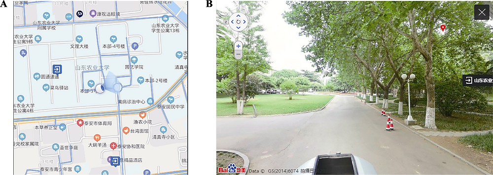
图1 研究样点街道视图实例。A, 样点位置。B, 样点对应的百度街景影像。
Fig. 1 An example of study site view. A, Location of a sample point. B, Baidu Street View image corresponding to the sample point.
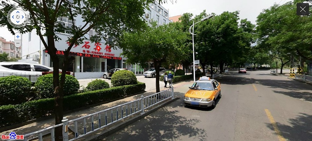
图2 百度街景图像示例。
Fig. 2 An example of Baidu Street View image.
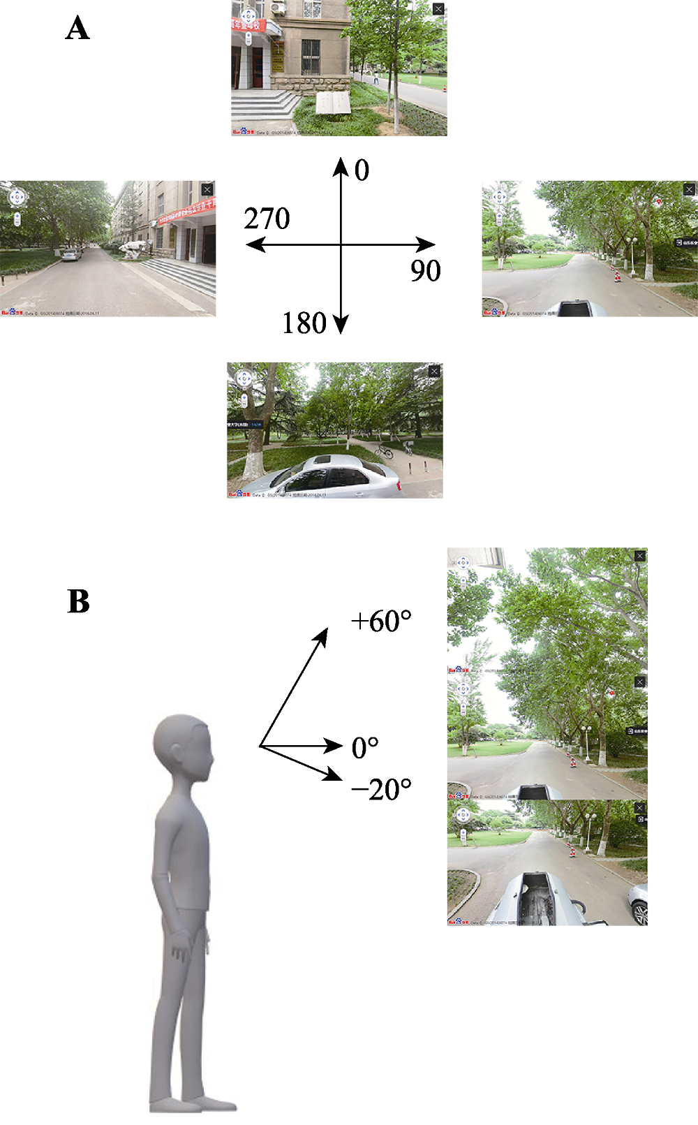
图3 街道样点水平方向(A)和竖直视角(B)上获取的百度街景图像。
Fig. 3 Baidu Street View images in horizontal view (A) and vertical view (B).
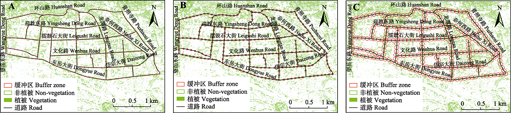
图4 泰安市区道路系统研究样点的缓冲区。A, 10 m缓冲区。B, 20 m缓冲区。C, 50 m缓冲区。
Fig. 4 Buffer zones of the study sites in street system of Tai’an. A, 10 m buffer zones. B, 20 m buffer zones. C, 50 m buffer zones.
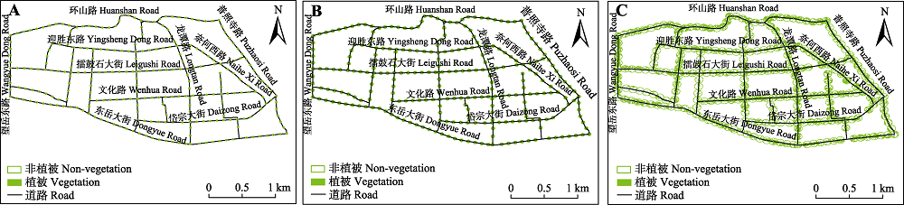
图5 求交处理后泰安市区道路系统缓冲区内的植被区域。A, 10 m缓冲区。B, 20 m缓冲区。C, 50 m缓冲区。
Fig. 5 Vegetation area in the buffer area of street system of Tai’an after intersection processing. A, 10 m buffer zones. B, 20 m buffer zones. C, 50 m buffer zones.
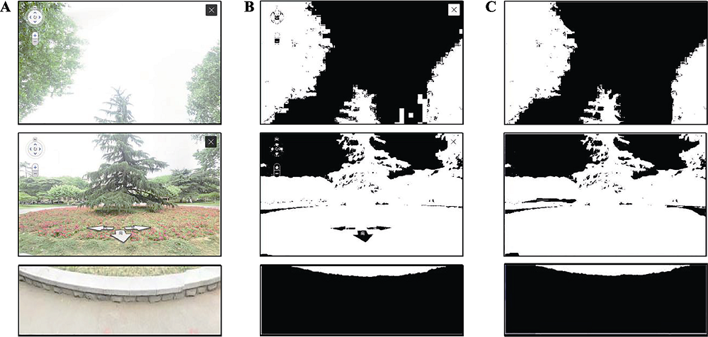
图6 泰安市百度街景提取结果实例。A, 原始百度街景图像。B, 最大似然方法处理结果。C, 人工处理结果。
Fig. 6 An example of classification result of Baidu Street View (BSV) image in Tai?an. A, Original BSV image. B, Classification results using Maximum Likelihood Classificer. C, Artificial classification results.
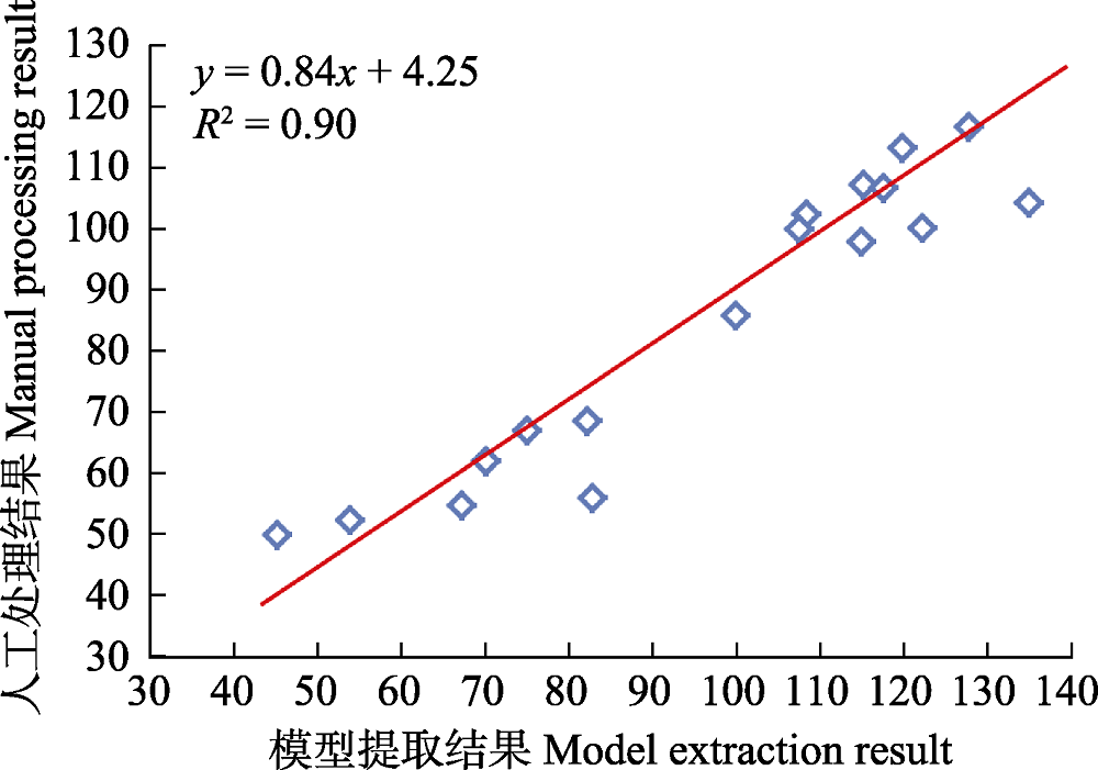
图7 监督分类计算泰安市百度街道植被分布指数与人工处理结果散点图。
Fig. 7 Scatter plot of Baidu Street View Distribution Index (BSVDI) results in Tai?an using maximum likelihood classification and artificial extraction method.
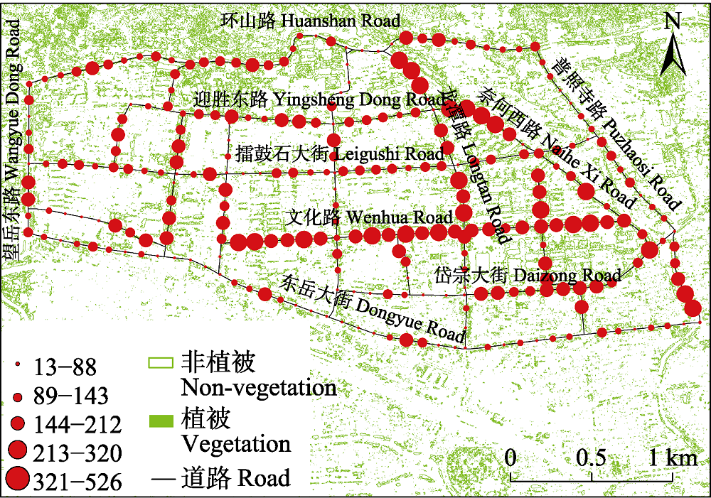
图8 泰安市案例区百度街道植被分布指数值分布格局。
Fig. 8 Baidu Street View Distribution Index (BSVDI) distributing pattern in the study area of Tai?an.
| 编号 ID | 走向 Orientation | 街道名称 Name of street | BSVDI | 汇总 Sum | ||||
|---|---|---|---|---|---|---|---|---|
| 一级 First class [13, 88) | 二级 Second class [89, 143) | 三级 Third class [144, 212) | 四级 Fourth class [213, 320) | 五级 Fifth class [321, 526) | ||||
| 0 | 东-西 East-West | 环山路 Huanshan Road | 5 | 13 | 12 | 4 | 0 | 34 |
| 1 | 东-西 East-West | 迎胜东路 Yingsheng Dong Road | 3 | 5 | 8 | 3 | 0 | 19 |
| 2 | 东-西 East-West | 擂鼓石大街 Leigushi Road | 8 | 9 | 17 | 1 | 0 | 35 |
| 3 | 东-西 East-West | 文化路 Wenhua Road | 0 | 1 | 2 | 14 | 8 | 25 |
| 4 | 东-西 East-West | 御碑楼南街 Yubeilou Nan Road | 3 | 1 | 1 | 2 | 0 | 7 |
| 5 | 东-西 East-West | 岱宗大街 Daizong Road | 7 | 3 | 5 | 5 | 1 | 21 |
| 6 | 东-西 East-West | 东岳大街 Dongyue Road | 21 | 15 | 4 | 2 | 0 | 42 |
| 7 | 南-北 South-North | 傲来峰路 Aolaifeng Road | 4 | 3 | 3 | 1 | 0 | 11 |
| 8 | 南-北 South-North | 附中西路 Fuzhong Xi Road | 0 | 0 | 2 | 1 | 0 | 3 |
| 9 | 南-北 South-North | 校场街路 Jiaochangjie Road | 0 | 1 | 0 | 5 | 1 | 7 |
| 10 | 南-北 South-North | 科山路 Keshan Road | 2 | 1 | 1 | 2 | 0 | 6 |
| 11 | 南-北 South-North | 龙潭路 Longtan Road | 3 | 3 | 0 | 4 | 5 | 15 |
| 12 | 南-北 South-North | 奈河西路 Naihe Xi Road | 1 | 2 | 2 | 1 | 5 | 11 |
| 13 | 南-北 South-North | 普照寺路 Puzhaosi Road | 3 | 7 | 5 | 1 | 2 | 18 |
| 14 | 南-北 South-North | 望岳东路 Wangyue Dong Road | 1 | 2 | 2 | 2 | 0 | 7 |
| 15 | 南-北 South-North | 迎胜路 Yingsheng Road | 1 | 0 | 2 | 4 | 0 | 7 |
| 16 | 南-北 South-North | 中心医院西路 Zhongxinyiyuan Xi Road | 1 | 0 | 1 | 1 | 0 | 3 |
| 17 | 南-北 South-North | 东尊西路 Dongzun Xi Road | 0 | 1 | 1 | 0 | 0 | 2 |
| 汇总 Sum | 63 | 67 | 68 | 53 | 22 | 273 | ||
表1 泰安市研究样点百度街道植被分布指数(BSVDI)分级统计结果
Table 1 Baidu Street View Distribution Index (BSVDI) gradation results of the study sites
| 编号 ID | 走向 Orientation | 街道名称 Name of street | BSVDI | 汇总 Sum | ||||
|---|---|---|---|---|---|---|---|---|
| 一级 First class [13, 88) | 二级 Second class [89, 143) | 三级 Third class [144, 212) | 四级 Fourth class [213, 320) | 五级 Fifth class [321, 526) | ||||
| 0 | 东-西 East-West | 环山路 Huanshan Road | 5 | 13 | 12 | 4 | 0 | 34 |
| 1 | 东-西 East-West | 迎胜东路 Yingsheng Dong Road | 3 | 5 | 8 | 3 | 0 | 19 |
| 2 | 东-西 East-West | 擂鼓石大街 Leigushi Road | 8 | 9 | 17 | 1 | 0 | 35 |
| 3 | 东-西 East-West | 文化路 Wenhua Road | 0 | 1 | 2 | 14 | 8 | 25 |
| 4 | 东-西 East-West | 御碑楼南街 Yubeilou Nan Road | 3 | 1 | 1 | 2 | 0 | 7 |
| 5 | 东-西 East-West | 岱宗大街 Daizong Road | 7 | 3 | 5 | 5 | 1 | 21 |
| 6 | 东-西 East-West | 东岳大街 Dongyue Road | 21 | 15 | 4 | 2 | 0 | 42 |
| 7 | 南-北 South-North | 傲来峰路 Aolaifeng Road | 4 | 3 | 3 | 1 | 0 | 11 |
| 8 | 南-北 South-North | 附中西路 Fuzhong Xi Road | 0 | 0 | 2 | 1 | 0 | 3 |
| 9 | 南-北 South-North | 校场街路 Jiaochangjie Road | 0 | 1 | 0 | 5 | 1 | 7 |
| 10 | 南-北 South-North | 科山路 Keshan Road | 2 | 1 | 1 | 2 | 0 | 6 |
| 11 | 南-北 South-North | 龙潭路 Longtan Road | 3 | 3 | 0 | 4 | 5 | 15 |
| 12 | 南-北 South-North | 奈河西路 Naihe Xi Road | 1 | 2 | 2 | 1 | 5 | 11 |
| 13 | 南-北 South-North | 普照寺路 Puzhaosi Road | 3 | 7 | 5 | 1 | 2 | 18 |
| 14 | 南-北 South-North | 望岳东路 Wangyue Dong Road | 1 | 2 | 2 | 2 | 0 | 7 |
| 15 | 南-北 South-North | 迎胜路 Yingsheng Road | 1 | 0 | 2 | 4 | 0 | 7 |
| 16 | 南-北 South-North | 中心医院西路 Zhongxinyiyuan Xi Road | 1 | 0 | 1 | 1 | 0 | 3 |
| 17 | 南-北 South-North | 东尊西路 Dongzun Xi Road | 0 | 1 | 1 | 0 | 0 | 2 |
| 汇总 Sum | 63 | 67 | 68 | 53 | 22 | 273 | ||
| 缓冲距离 Buffer distance (m) | Pearson相关系数 Pearson correlation coefficients | 样本点数量 Number of sample points |
|---|---|---|
| 10 | 0.76** | 273 |
| 20 | 0.63** | |
| 50 | 0.49** |
表2 泰安市百度街道植被分布指数与植被覆盖面积相关性分析
Table 2 Correlation analysis between Baidu Street View Distribution Index (BSVDI) and vegetation coverage area in Tai?an
| 缓冲距离 Buffer distance (m) | Pearson相关系数 Pearson correlation coefficients | 样本点数量 Number of sample points |
|---|---|---|
| 10 | 0.76** | 273 |
| 20 | 0.63** | |
| 50 | 0.49** |
| [1] | Aoki Y, Yasuoka Y, Naito M (1985). Assessing the impression of street-side greenery. Landscape Research, 10, 9-13. |
| [2] | Bai Y, Wang XY, Jiang HM, Liu SD (2013). Progress of urban heat island effect. Journal of Meteorology and Environment, 29(2), 101-106. |
| [ 白杨, 王晓云, 姜海梅, 刘寿东 (2013). 城市热岛效应研究进展. 气象与环境学报, 29(2), 101-106.] | |
| [3] | Bu F, Shi YL (2017). The comparison of urban tree crown extraction based on airborne LiDAR elevation difference and high resolution imagery. Remote Sensing Technology and Application, 32, 875-882. |
| [ 卜帆, 石玉立 (2017). 机载LiDAR高差和高分影像的城市树冠提取比较. 遥感技术与应用, 32, 875-882.] | |
| [4] |
Camacho-Cervantes M, Schondube JE, Castillo A, MacGregor- Fors I (2014). How do people perceive urban trees? Assessing likes and dislikes in relation to the trees of a city. Urban Ecosystems, 17, 761-773.
DOI URL |
| [5] | Chen QN (1984). The use of Tianjin colour infrared film in the study of the relationship between vegetation and air pollution. Acta Phytoecologica et Geobotanica Sinica, 8, 112-122. |
| [ 陈庆男 (1984). 天津市彩色红外相片在研究植被与大气污染关系中的应用. 植物生态学与地植物学丛刊, 8, 112-122.] | |
| [6] | Cui W, Xiang Q (2018). Design and study of high precision laser rangefinder. Laser Journal, 39(7), 46-49. |
| [ 崔崴, 向茜 (2018). 高精度激光测距仪的设计与研究. 激光杂志, 39(7), 46-49.] | |
| [7] |
Di SC, Li ZL, Tang RL, Pan XY, Liu HL, Niu Y (2019). Urban green space classification and water consumption analysis with remote-sensing technology: a case study in Beijing, China. International Journal of Remote Sensing, 40, 1909-1929.
DOI URL |
| [8] | Downs RM, Stea D, Meining DW (1977). Maps in Minds: Reflections on Cognitive Mapping. Harper and Row, New York. |
| [9] | Golombek Y, Marshall WE (2019). Use of aerial LiDAR in measuring streetscape and street trees. Transportation Research Record, 2673(4), 125-135. |
| [10] |
Heo HK, Lee DK, Park JH, Thorne JH (2019). Estimating the heights and diameters at breast height of trees in an urban park and along a street using mobile LiDAR. Landscape and Ecological Engineering, 15, 253-263.
DOI URL |
| [11] |
Klemm W, Heusinkveld BG, Lenzholzer S, van Hove B (2015). Street greenery and its physical and psychological impact on thermal comfort. Landscape and Urban Planning, 138, 87-98.
DOI URL |
| [12] | Li J, Zhao JJ, Chen SS, Chen CD, Zhang QX (2017). Species composition of urban alien plants in Xiamen, China. Ecology and Environmnetal Sciences, 26, 20-26. |
| [ 李净, 赵娟娟, 陈珊珊, 陈春娣, 张启翔 (2017). 厦门市城市外来植物的种类构成. 生态环境学报, 26, 20-26.] | |
| [13] | Li W (2007). The Application of CITYgreen in Urban Green-land Ecological Benefits Evaluation. Master degree dissertation, Beijing Forestry University, Beijing. 1-3. |
| [ 李薇 (2007). CITYgreen软件在城市绿地生态效益评价中的应用——以奥林匹克森林公园规划方案为例. 硕士学位论文, 北京林业大学, 北京. 1-3.] | |
| [14] | Li Z, Sun RH, Zhang JC, Zhang C (2017). Temporal-spatial analysis of vegetation coverage dynamics in Beijing- Tianjin-Hebei metropolitan regions. Acta Ecologica Sinica, 37, 7418-7426. |
| [ 李卓, 孙然好, 张继超, 张翀 (2017). 京津冀城市群地区植被覆盖动态变化时空分析. 生态学报, 37, 7418-7426.] | |
| [15] | Liu HY (2007). The Current Situation, Problems and Path Selection of Eco-city Construction in China: a Case Study of Taiʼan City, Shandong Province. Master degree dissertation, Hubei University, Wuhan. 17. |
| [ 刘含艳 (2007). 我国生态城市建设的现状、问题及路径选择——以山东省泰安市为例. 硕士学位论文, 湖北大学, 武汉. 17.] | |
| [16] | Ren XH, Tian HX, Liu Y (2006). Preliminary study on spatial difference of the vegetation coverage adjusting to climate. Journal of Yunnan Agricultural University, 21, 806-810. |
| [ 任学慧, 田红霞, 刘瑜 (2006). 植被覆盖调节气候空间差异性的初步研究. 云南农业大学学报, 21, 806-810.] | |
| [17] | Su Y, Bao Y (2018). Spatial-temporal characteristics of urban heat island effect in Hanzhong City in recent 20 years based on mono-window algorithm. Journal of Northwest Forestry University, 33(4), 183-192. |
| [ 苏嫄, 包玉 (2018). 基于单窗算法的汉中市近20年城市热岛效应时空特征. 西北林学院学报, 33(4), 183-192.] | |
| [18] | Sun P (2006). Try to construct a pattern of sustainable development for resource-oriented cities based on people-centered development. Planners, 22(4), 5-6. |
| [ 孙平 (2006). 以人为本努力构建资源型城市可持续发展模式. 规划师, 22(4), 5-6.] | |
| [19] | Sun Y (2007). Three-dimensional Terrain Construction of Robot and Obstacle Detection in Grass Based on LiDAR. Master degree dissertation, Zhejiang University, Hangzhou. |
| [ 孙宇, (2007). 基于激光雷达的机器人三维地形构建和草丛中障碍物检测. 硕士学位论文, 浙江大学, 杭州.] | |
| [20] | van Dillen SME, de Vries S, Groenewegen PP, Spreeuwenberg P (2012). Greenspace in urban neighbourhoods and residents’ health: adding quality to quantity. Journal of Epidemiology & Community Health, 66, e8. DOI: 10.1136/jech.2009.104695. |
| [21] | Wang FJ (2004). Guided by the scientific concept of development, improve the level of urban landscaping. Beijing Garden, 20(4), 3-11. |
| [ 王凤江 (2004). 以科学的发展观为指导, 提升城市园林绿化水平——关于充分发挥园林绿化作用, 实现城市可持续发展的研究与思考. 北京园林, 20(4), 3-11.] | |
| [22] | Wang G, Zhang QP, Xiao RB, Guan DS (2017). Urban thermal island regulated by green spaces—A case study of Guangzhou. Ecological Science, 36(1), 170-176. |
| [ 王刚, 张秋平, 肖荣波, 管东生 (2017). 城市绿地对热岛效应的调控功能研究——以广州为例. 生态科学, 36(1), 170-176.] | |
| [23] | Wang J, Yang HQ, Feng ZK (2013). Tridimensional green biomass measurement for trees using 3-D laser scanning. Transactions of the Chinese Society for Agricultural Machinery, 44(8), 229-233. |
| [ 王佳, 杨慧乔, 冯仲科 (2013). 基于三维激光扫描的树木三维绿量测定. 农业机械学报, 44(8), 229-233.] | |
| [24] | Wang J, Zhou WQ, Xu KP, Yan JL (2017). Spatiotemporal pattern of vegetation cover and its relationship with urbanization in Beijing-Tianjin-Hebei megaregion from 2000 to 2010. Acta Ecologica Sinica, 37, 7019-7029. |
| [ 王静, 周伟奇, 许开鹏, 颜景理 (2017). 京津冀地区城市化对植被覆盖度及景观格局的影响. 生态学报, 37, 7019-7029.] | |
| [25] | Wang JJ, Li XL, Xu TL, Li DX, Huo WX (2015). Comparison of impacts of control errors and measurement errors of working parameters on accuracies of point cloud products from airborne LiDAR. Chinese Journal of Lasers, 42(7), 202-210. |
| [ 王建军, 李小路, 许同乐, 李东兴, 霍文骁, (2015). 机载LiDAR中工作参数的控制误差和测量误差对点云产品精度的影响机理及其比较. 中国激光, 42(7), 202-210.] | |
| [26] | Wang SY, Zhang ZX, Zhou QB, Wang CY (2002). Study on spatial-temporal features of land use/land cover change based on technologies of RS and GIS. Journal of Remote Sensing, 6, 223-228. |
| [ 王思远, 张增祥, 周全斌, 王长有 (2002). 基于遥感与GIS技术的土地利用时空特征研究. 遥感学报, 6, 223-228.] | |
| [27] | Wang ZH, Li JB (2006). Capacity of dust uptake by leaf surface of Euonymus japonicus Thunb. and the morphology of captured particle in air polluted city. Ecology and Environment, 15, 327-330. |
| [ 王赞红, 李纪标 (2006). 城市街道常绿灌木植物叶片滞尘能力及滞尘颗粒物形态. 生态环境, 15, 327-330.] | |
| [28] | Wei D, Li L, Ni XL (2017). Evaluation of urban forest ecosystem service function in Yinchuan botanical garden. Xiandai Horticulture, (21), 12-15. |
| [ 魏冬, 李龙, 倪细炉 (2017). 银川植物园城市森林生态系统服务功能评价. 现代园艺, (21), 12-15.] | |
| [29] | Wu JS, Yuan T, Wang T (2017). Preliminary theory of urban landscape esthetics based on three-dimensional landscape indicators. Acta Ecologica Sinica, 37, 4519-4528. |
| [ 吴健生, 袁甜, 王彤 (2017). 基于三维景观指数的城市景观美学特征定量表达——以深圳市为例. 生态学报, 37, 4519-4528.] | |
| [30] |
Yang CB, He XY, Wang RH, Yan FQ, Yu LX, Bu K, Yang JC, Chang LP, Zhang SW (2017). The effect of urban green spaces on the urban thermal environment and its seasonal variations. Forests, 8, 153. DOI: 10.3390/f8050153.
DOI URL |
| [31] |
Yang ZQ, Chen BZ, Zha TS, Jia X (2016). Relationship between photochemical reflectance index with multi-anglehyper-spectrum and light use efficiency in urban green-land ecosystems. Chinese Journal of Plant Ecology, 40, 1077-1089.
DOI URL |
|
[ 杨志青, 陈报章, 查天山, 贾昕 (2016). 城市绿地生态系统多角度高光谱光化学反射植被指数与光能利用率的关系. 植物生态学报, 40, 1077-1089.]
DOI URL |
|
| [32] | Zhang JH (2017). Visibility Assessment of Urban Street-level Greenery Using Street View Imagery and LiDAR. Master degree dissertation, University of Chinese Academy of Sciences,Beijing. 1-2. |
| [ 张佳晖 (2017). 基于街景和LiDAR的行道树绿视面积计算研究. 硕士学位论文, 中国科学院大学, 北京. 1-2.] | |
| [33] | Zhang JH, Meng QY, Sun YX, Sun ZH, Zhang LL (2017). Study on urban green view index. Journal of Geo-Information Science, 19, 838-845. |
| [ 张佳晖, 孟庆岩, 孙云晓, 孙震辉, 张琳琳 (2017). 城市行道树绿视量指数研究. 地球信息科学学报, 19, 838-845.] |
| [1] | 朱绪超, 袁国富, 邵明安, 易小波, 杜涛. 塔里木河下游河岸带植被的空间结构特征[J]. 植物生态学报, 2015, 39(11): 1053-1061. |
| [2] | 张庆, 牛建明, 韩芳, 董建军, 张艳楠, 康萨如拉, 杨艳. 不同坡位植被分异及土壤效应——以内蒙古短花针茅草原为例[J]. 植物生态学报, 2011, 35(11): 1167-1181. |
| [3] | 杨永川, 达良俊. 丘陵地区地形梯度上植被格局的分异研究概述[J]. 植物生态学报, 2006, 30(3): 504-513. |
| [4] | 张化永, 邬建国, 韩兴国. 植被的组织有序度及其全球格局[J]. 植物生态学报, 2002, 26(2): 129-139. |
| [5] | 马克明, 祖元刚. 植被格局的分形模型:植被格局的分形特征[J]. 植物生态学报, 2000, 24(1): 111-117. |
| 阅读次数 | ||||||
|
全文 |
|
|||||
|
摘要 |
|
|||||
Copyright © 2026 版权所有 《植物生态学报》编辑部
地址: 北京香山南辛村20号, 邮编: 100093
Tel.: 010-62836134, 62836138; Fax: 010-82599431; E-mail: apes@ibcas.ac.cn, cjpe@ibcas.ac.cn
备案号: 京ICP备16067583号-19
![]()