
植物生态学报 ›› 2006, Vol. 30 ›› Issue (3): 504-513.DOI: 10.17521/cjpe.2006.0067
杨永川1,2,3( ), 达良俊3,4
接受日期:2005-08-04
出版日期:2006-05-30
发布日期:2006-05-30
作者简介:E-mail: yongchuanyang@yahoo.com.cn
基金资助:
YANG Yong-Chuan1,2,3(), DA Liang-Jun3,4
Accepted:2005-08-04
Online:2006-05-30
Published:2006-05-30
摘要:
植物群落的本质特征之一是群落中的植物和环境之间存在一定的相互关系。湿润的丘陵地区是由水侵蚀而形成的包含各种干扰频率的生境复合体,作为中尺度的地形单位,可以通过侵蚀前线划分为上部坡面和下部坡面两个小尺度的地形单位,而上部坡面可以进一步划分为顶坡、上部边坡、谷头凹地等微地形单元,下部坡面可以进一步划分为下部边坡、麓坡、泛滥性阶地及谷床等微地形单元。上部坡面发育的是气候顶极群落,沿顶坡向谷头凹地,群落发生逐渐、连续的变化,下部坡面发育的为地形群落,其物种组成、结构以及其它生态特征与上部坡面具有显著的差异,而其微地形单元之间植被的变化不明显。干扰作用是不同地形植被分异的控制因子,也是地形植被维持和更新的关键因子。下部坡面以相对积极的土壤侵蚀、滑坡和崩塌等过程为特征,其植被更新依赖于频繁的地面干扰,而上部坡面长期稳定,其植被更新依赖于林窗动态。地形是影响植被格局的最重要的也是最基本的生境因子,其引起的生境生态位分化为物种的共存提供了条件,导致了小尺度空间内高生物多样性的形成和维持。
杨永川, 达良俊. 丘陵地区地形梯度上植被格局的分异研究概述. 植物生态学报, 2006, 30(3): 504-513. DOI: 10.17521/cjpe.2006.0067
YANG Yong-Chuan, DA Liang-Jun. A BRIEF REVIEW OF STUDIES ON DIFFERENTIATION OF VEGETATION PATTERN ALONG A TOPOGRAPHIC GRADIENT IN HILLY REGIONS. Chinese Journal of Plant Ecology, 2006, 30(3): 504-513. DOI: 10.17521/cjpe.2006.0067
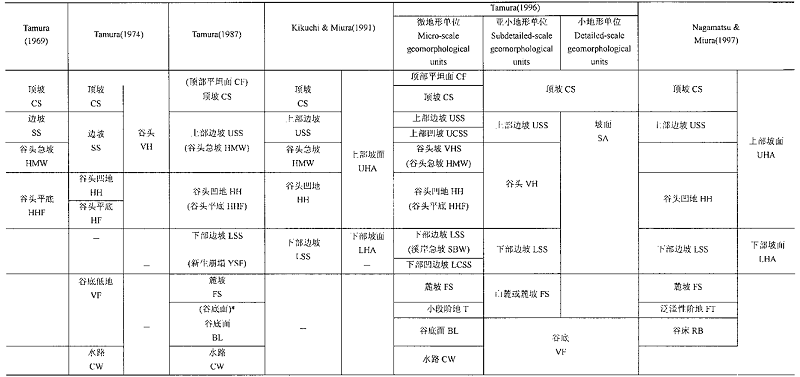 |
表1 坡面的微地形 分类及其比较(改自Kikuchi, 2001)
Table 1 The landform classfication systems and their comparisons (Modified from Kikuchi, 2001)
| |
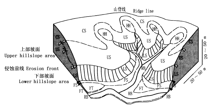
图1 丘陵地微地形区分模式图(改自Nagamatsu & Miura, 1997) CS:顶坡 Crest slope US:上部边坡 Upper sideslope HH:谷头凹地 Head hollow LS:下部边坡 Lower sideslope FS:麓坡 Foot slope FT:泛滥性阶地 Flood terrace RB:谷床 Rive bed △和▲分别代表凸和凹的坡面变换 △ and ▲ indicate convex and concave break of slope, respectively
Fig.1 The schematic diagram of the micro-landforms in a hilly area(Modified from Nagamatsu & Miura, 1997)
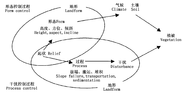
图2 地形因子对植被作用的过程(改自Kikuchi,2001)
Fig.2 The effects of landforms on the vegetation (Modified from Kikuchi, 2001)
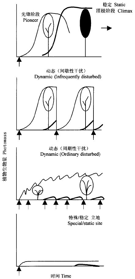
图3 不同地貌特征的演替格局 箭头表示一次干扰,粗黑线表示顶极种
Fig.3 Illustration of succession pattern on sites with different geomorphic features The arrow indicates one disturbance and the thick black line indicates the climax species
| [1] | Ann SW, Oshima Y (1996). Structure and regeneration of Fraxinus spaethiana-Pterocarya rhoifolia forests in unstable valleys in the Chichibu Mountains, Central Japan . Ecological Research, 11,363-370. |
| [2] |
Antos JA, Roberta P (2002). Structure and dynamics of a nearly steady-state subalpine forest in south-central British Columbia, Canada. Oecologia, 130,126-135.
DOI URL PMID |
| [3] |
Bond WJ, Midgley JJ (2001). Ecology of sprouting in woody plants: the persistence niche. Trends in Ecology and Evolution, 16,45-51.
DOI URL PMID |
| [4] | Enoki T (2003). Microtopography and distribution of canopy trees in a subtropical evergreen broad-leaved forest in the northern part of Okinawa Island, Japan. Ecological Research, 18,103-113. |
| [5] | Fang JY (方精云) (2004). Exploring altitudinal pattern of plant diversity of China's mountains. Biodiversity Science (生物多样性), 12,1-4. (in Chinese with English abstract) |
| [6] | Graham B, Martin JL, Marcia JW (2000). Environmental heterogeneity and species diversity of forest sedges. Journal of Ecology, 88,67-87. |
| [7] | Hara M, Hirata K, Fujihara M, Oono K (1996a). Vegetation structure in relation to micro-landform in an evergreen broad-leaved forest on Amami Ohshima Island, South-West Japan. Ecological Research, 11,325-337. |
| [8] | Hara M, Hiroshi K, Oono K (1996b). Relationship between micro-landform and vegetation structure in an evergreen broad-leaved forest on Okinawa Island, S-W. Japan. Natural History Re-search, 4,27-35. |
| [9] | HortonRE (1945). Erosional development of streams and their drainage basins: hydrophysical approach to quantitative morphology. Bulletin of the Geological Society of America, 56,275-370. |
| [10] | Hunter JC, Parker VT (1993). The disturbance regime of an old-growth forest in coastal California. Journal of Vegetation Science, 4,19-24. |
| [11] | Isobe H, Kikuchi T (1989). Differences in shoot form and age of Aucuba japonica Thunb. corresponding to the micro-landforms on a hill slope . Ecological Review, 21,277-281. |
| [12] | Johnston MH (1992). Soil-vegetation relationships in a tabonuco forest community in the Luquillo Mountains of Puerto Rico. Journal of Tropic Ecology, 8,253-263. |
| [13] | Kikuchi T (1990). A DCA analysis of floristic variation of plant communities in relation to micro-landform variation in a hillside area. Ecological Review, 22,25-31. |
| [14] | Kikuchi T, Miura O (1991). Differentiation in vegetation related to micro-scale landforms with special reference to the lower sideslope. Ecological Review, 22,61-70. |
| [15] | Kikuchi T, Miura O (1993). Vegetation patterns in relation to micro-scale landforms in hilly land regions. Vegetatio, 106,147-154. |
| [16] | Kikuchi T (2001). Vegetation and Landforms. University of Tokyo Press, Tokyo,2-93.(in Japanese). |
| [17] | Leak WB (1991). Secondary forest succession in New Hampshire, USA. Forest Ecology and Management, 43,69-86. |
| [18] | Miura O, Kikuchi T (1978). Preliminary investigation on vegetation and micro-landforms at a valley head in the hills. In: Editorial Committee for Papers to the Memory of Dr. Kuniji Yoshioka eds. Papers on Plant Ecology to the Memory of Dr. Kuniji Yoshioka. Society of Plant Ecology, Tohoku, Sendai,466-477.(in Japanese). |
| [19] | Nagamatsu D, Miura O (1997). Soil disturbance regime in relation to micro-scale landforms and its effects on vegetation structure in a hilly area in Japan. Plant Ecology, 133,191-200. |
| [20] | Nagamatsu D, Seida K, Sakai A (2002). Seedling establishment of deciduous trees in various topographaphic positions. Journal of Vegetation Science, 13,35-44. |
| [21] | Nagamatsu D, Yoshihiko H, Mochida Y (2003). Influence of micro-landforms on forest structure, tree death and recruitment in a Japanese temperate mixed forest. Ecological Research, 18,533-547. |
| [22] | Nakamura F, Yajima T, Kikuchi SI (1997). Structure and composition of riparian forests with reference to geomorphic site conditions along the Tokachi River, Northern Japan. Plant Ecology, 133,209-219. |
| [23] | Newbery DM, Campbell EJF, Proctor J, Still MJ (1996). Primary lowland dipterocarp forest at Danum Valley, Sabah, Malaysia. Species composition and patterns in the understorey. Vegetatio, 122,193-220. |
| [24] | Ohsawa M, Ozaki K (1992). Hierarchical analysis of vegetation / environment pattern for east Asian extra-tropical evergreen broad-leaved forests. Japanese Journal of Biometeor, 29,93-103. |
| [25] | Ohtuka T, Sakura T, Ohsawa M (1993). Early herbaceous succession along a topographical gradient on forest clear-felling sites in mountainous terrain, central Japan. Ecological Research, 8,329-340. |
| [26] | Ozaki K, Ohsawa M (1995). Successional change of forest pattern along topographical gradients in warm-temperate mixed forests in Mt. Kiyosumi, Central Japan. Ecological Research, 10,223-234. |
| [27] | Sakai A, Ohsawa M (1993). Vegetation pattern and microtopography on a landslide scar of Mt Kiyosumi, Central Japan. Ecological Research, 8,47-56. |
| [28] | Sakai A, Ohsawa M (1994). Topographical pattern of the forest vegetation on a river basin in a warm-temperate hilly region, Central Japan. Ecological Research, 9,269-280. |
| [29] | Sakio H (1997). Effects of natural disturbance on the regeneration of riparian forests in a Chichibu Mountains, Central Japan. Plant Ecology, 132,181-195. |
| [30] | Shen ZH (沈泽昊), Zhang XS (张新时) (2000). The spatial pattern and topographic interpretation of the forest vegetation at Dalaoling region in the Three Gorges. Acta Phytoecologica Sinica (植物生态学报), 42,1089-1095. (in Chinese with English abstract) |
| [31] | Shen ZH (沈泽昊), Zhang XS (张新时), Jin YX (金义兴) (2000a). An analysis of the topographical pattern of the chief woody species at Dalaoling mountain in the Three Gorges region. Acta Phytoecologica Sinica (植物生态学报), 24,581-589. (in Chinese with English abstract) |
| [32] | Shen ZH (沈泽昊), Zhang XS (张新时), Jin YX (金义兴) (2000b). Spatial pattern analysis and topographical interpretation of species diversity in the forests of Dalaoling in the region of the Three Gorges. Acta Botanica Sinica (植物学报), 42,620-627. (in Chinese with English abstract) |
| [33] | Shen ZH (沈泽昊) (2002). A multi-scale study on the vegetation-environment relationship of a mountain forest transect. Acta Ecologica Sinica (生态学报), 22,461-470. (in Chinese with English abstract) |
| [34] | Shen ZH (沈泽昊), Lü N (吕楠), Zhao J (赵俊) (2004). The topographic pattern of seed rain of a mountain mixed evergreen and deciduous forest community. Acta Ecologica Sinica (生态学报), 24,1981-1987. (in Chinese with English abstract) |
| [35] | Shumiya T, Ohtsuka T, Ohsawa M (1999). Micro-landform and soil conditions along topographical transect in Anaga cloud forest. In: Ohsawa M, Wildpret W, Del Arco M eds. Anaga Cloud Forest-A Comparative Study on Evergreen Broad-Leaved Forests and Trees of the Canaries and Japan. Chiba University, Chiba, Japan,55-68. |
| [36] | Song YC (宋永昌) (2001). Vegetation Ecology (植被生态学). East China Normal University Press, Shanghai, 142. (in Chinese) |
| [37] | StrahlerAN (1952). Hypsometric (Area-altitude) analysis of erosional topography. Bulletin of the Geological Society of America, 63,1117-1142. |
| [38] | StrahlerAN (1957). Quantitative analysis of watershed geomorphology. Transcriptions of the American Geophysics Union, 38,913-920. |
| [39] | Takyu M, Ohsawa M (1997). Distribution and regeneration strategies of major canopy dominants in species-rich subtropical/warm-temperate rain forests, Southwestern Japan. Ecological Research, 12,139-151. |
| [40] | Takyu M, Aiba SI, Kitayama K (2002). Effects of topography on tropical lower montane forests under different geological conditions on Mount Kinabalu, Borneo. Plant Ecology, 159,35-49. |
| [41] | Tamura T (1969). A series of micro-landform units composing valley heads in the hills near Sendai. Science Report of the Tohoku University, 7th Series (Geography), 19,11-127. |
| [42] | Tamura T (1974). Micro-landform units composing a valley head area and their geomorphic significance. Annals of the Tohoku geographical Association, 26,189-199.(in Japanese with English abstract). |
| [43] | Tamura T, Takeuchi K (1980). Land characteristics of the hills and their modification by man-with special reference to a few cases in the Tama Hills, west of Tokyo-Essays in Geography of Tokyo. Geographical Reports of Tokyo Metropolitan University, 14/15,49-94. |
| [44] | Tamura T (1987). Landform-soil features of the humid temperate hills. Pedologist, 31,135-146. (in Japanese). |
| [45] | Tamura T, Miyagi T (1987). Landslides after the forest fire in the Tomiya Hills, north of Sendai. In: Iizumi S ed. Ecology of Forest Fire: Fire Behavior in Forest Area and Fire Effects on Ecosystem. Forest Fire Group, Tohoku University, Sendai,331-340. |
| [46] | Tang CQ, Ohsawa M (2002). Coexistence mechanisms of evergreen, deciduous and coniferous trees in a mid-montane mixed forest on Mt. Emei, Sichuan, China. Plant Ecology, 161,215-230. |
| [47] | Tanner EVJ, Kapos V, Franco W (1992). Nitrogen and phosphorus fertilization effects on Venezuelan montane forest trunk growth and litterfall. Ecology, 73,78-86. |
| [48] | Tateno R, Takeda H (2003). Forest structure and tree species distribution in relation to topography-mediated heterogeneity of soil nitrogen and light at the forest floor. Ecological Research, 18,559-571. |
| [49] | Tokuchi N, Takeda H, Yoshida K (1999). Topographical variations in a plant-soil system along a slope on Mt Ryuoh, Japan. Ecological Research, 14,361-369. |
| [50] | Yanagisawa N, Fujita N (1999). Different distribution patterns of woody species on a slope in relation to vertical root distribution and dynamics of soil moisture profiles. Ecological Research, 14,165-177. |
| [51] | Yang YC (杨永川), Da LJ (达良俊), You WH (由文辉) (2005). Vegetation structure in relation to micro-landform in Tiantong National Forest Park, Zhejiang, China. Acta Ecologica Sinica (生态学报), 25,2830-2840. (in Chinese with English abstract) |
| [52] | Yoshida N, Ohsawa M (1996). Different and maintenance of topo-community patterns with reference to regeneration dynamics in mixed cool temperate forests in the Chichibu Mountains, Central Japan. Ecological Research, 11,351-362. |
| [53] | Zhang M (张谧), Xiong GM (熊高明), Chen ZG (陈志刚), Fang DY (樊大勇), Xie ZQ (谢宗强) (2004). The topography heterogeneity of Fagus engleriana-Cyclobanopsis oxyodon community in Shennongjia Region. Acta Ecologica Sinica (生态学报), 24,2686-2692. (in Chinese with English abstract) |
| [54] | Zhang M (张谧), Xiong GM (熊高明), Chen ZG (陈志刚), Fang DY (樊大勇), Xie ZQ (谢宗强) (2005). The application of digital elevation models in community biodiversity research with an example from a Fagus engleriana-Cyclobanopsis oxyodon community in Shennongjia Area . Acta Phytoecologica Sinica (植物生态学报), 29,197-201. (in Chinese with English abstract) |
| [1] | 李文博 孙龙 娄虎 于澄 韩宇 胡同欣. 火干扰对兴安落叶松种子萌发的影响[J]. 植物生态学报, 2024, 48(预发表): 0-0. |
| [2] | 张启, 程雪寒, 王树芝. 北京西山老龄树记载的森林干扰历史[J]. 植物生态学报, 2024, 48(3): 341-348. |
| [3] | 高敏, 缑倩倩, 王国华, 郭文婷, 张宇, 张妍. 低温胁迫对不同母树年龄柠条锦鸡儿种子萌发幼苗生理和生长的影响[J]. 植物生态学报, 2024, 48(2): 201-214. |
| [4] | 沈健, 何宗明, 董强, 郜士垒, 林宇. 轻度火烧对滨海沙地人工林土壤呼吸速率和非生物因子的影响[J]. 植物生态学报, 2023, 47(7): 1032-1042. |
| [5] | 冯可, 刘冬梅, 张琦, 安菁, 何双辉. 旅游干扰对松山油松林土壤微生物多样性及群落结构的影响[J]. 植物生态学报, 2023, 47(4): 584-596. |
| [6] | 刘婧, 缑倩倩, 王国华, 赵峰侠. 晋西北丘陵风沙区柠条锦鸡儿叶片与土壤生态化学计量特征[J]. 植物生态学报, 2023, 47(4): 546-558. |
| [7] | 王德利, 梁存柱. 退化草原的恢复状态: 气候顶极或干扰顶极?[J]. 植物生态学报, 2023, 47(10): 1464-1470. |
| [8] | 柳牧青, 杨小凤, 石钰铭, 刘雨薇, 李小蒙, 廖万金. 模拟酸雨对入侵植物豚草与伴生种鬼针草竞争关系的影响[J]. 植物生态学报, 2022, 46(8): 932-940. |
| [9] | 秦倩倩, 邱聪, 郑大柽, 刘艳红. 油松人工林火烧迹地早期土壤入渗动态[J]. 植物生态学报, 2021, 45(8): 903-917. |
| [10] | 李捷, 陈莹莹, 乔福云, 郅堤港, 郭正刚. 高原鼠兔干扰对高寒草甸β多样性的影响[J]. 植物生态学报, 2021, 45(5): 476-486. |
| [11] | 叶学华, 薛建国, 谢秀芳, 黄振英. 外部干扰对根茎型克隆植物甘草自然种群植株生长及主要药用成分含量的影响[J]. 植物生态学报, 2020, 44(9): 951-961. |
| [12] | 冯思远, 魏亚楠, 王振娟, 于新洋. 基于百度街景图像的行人视角城市街道植被绿化格局分析[J]. 植物生态学报, 2020, 44(3): 205-213. |
| [13] | 李帅锋, 郎学东, 黄小波, 王艳红, 刘万德, 徐崇华, 苏建荣. 云南普洱30 hm2季风常绿阔叶林动态监测样地群丛数量分类[J]. 植物生态学报, 2020, 44(3): 236-247. |
| [14] | 邓梦达, 游健荣, 李家湘, 李雄, 杨静, 邓创发, 刘昂, 刘文剑, 丁聪, 谢勇, 周国辉, 喻勋林. 长株潭城市群生态绿心地区主要植被类型的群落特征[J]. 植物生态学报, 2020, 44(12): 1296-1304. |
| [15] | 王艳红, 李帅锋, 郎学东, 黄小波, 刘万德, 徐崇华, 苏建荣. 地形异质性对云南普洱季风常绿阔叶林物种多样性的影响[J]. 植物生态学报, 2020, 44(10): 1015-1027. |
| 阅读次数 | ||||||
|
全文 |
|
|||||
|
摘要 |
|
|||||
Copyright © 2022 版权所有 《植物生态学报》编辑部
地址: 北京香山南辛村20号, 邮编: 100093
Tel.: 010-62836134, 62836138; Fax: 010-82599431; E-mail: apes@ibcas.ac.cn, cjpe@ibcas.ac.cn
备案号: 京ICP备16067583号-19