
Chin J Plant Ecol ›› 2021, Vol. 45 ›› Issue (8): 809-817.DOI: 10.17521/cjpe.2021.0065
Special Issue: 生态学研究的方法和技术
• Research Articles • Next Articles
JIA Ning-Xia1,2, GUO Ke1,2,*( ), SONG Chuang-Ye1, LIU Chang-Cheng1
Received:2021-02-25
Revised:2021-04-25
Online:2021-08-20
Published:2021-11-18
Contact:
* guoke@ibcas.ac.cn
Supported by:JIA Ning-Xia, GUO Ke, SONG Chuang-Ye, LIU Chang-Cheng. Principles of color and symbol design for vegetation mapping and a scheme of national vegetation map legends[J]. Chin J Plant Ecol, 2021, 45(8): 809-817.
Add to citation manager EndNote|Ris|BibTeX
URL: https://www.plant-ecology.com/EN/10.17521/cjpe.2021.0065
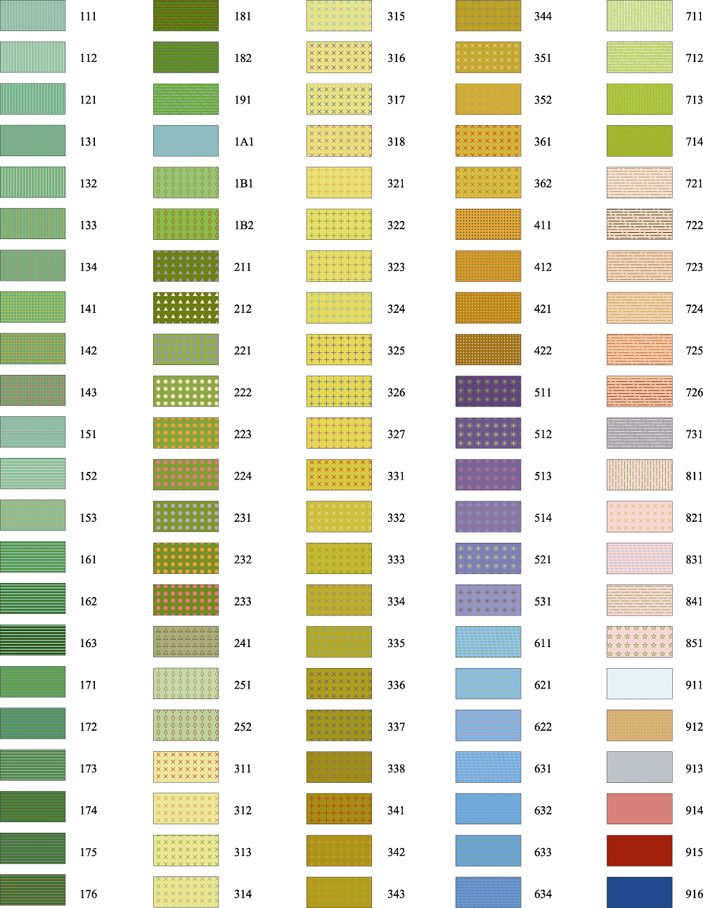
Fig. 1 The color and symbol design for national vegetation map legends. The first numeral represents Vegetation Formation Group, the second numeral represents Vegetation Formation, and the third numeral represents Vegetation Subformation. If the numbers are insufficient, they shall be replaced by capital English letters, where A represents the number 10 and B represents the number 11.
| 111 寒温性与温性落叶针叶林 | 181 雨林 | 315 丛生草类典型草甸 | 344 半灌木高寒草原 | 711 温性与暖性落叶果园 |
|---|---|---|---|---|
| 112 暖性落叶针叶林 | 182 山地雨林 | 316 丛生草类高寒草甸 | 351 温性灌草丛 | 712 温性与暖性落叶经济林 |
| 121 落叶与常绿针叶混交林 | 191 季雨林 | 317 丛生草类沼泽草甸 | 352 亚热带与热带灌草丛 | 713 暖性与热性常绿果园 |
| 131 寒温性常绿针叶林 | 1A1 红树林 | 318 丛生草类盐生草甸 | 361 热带滨海沙地稀树草丛 | 714 暖性与热性常绿经济林 |
| 132 温性常绿针叶林 | 1B1 暖性竹林 | 321 根茎草类典型草原 | 362 干热河谷稀树草丛 | 721 短生育期耐寒作物 |
| 133 暖性常绿针叶林 | 1B2 热性竹林 | 322 根茎草类草甸草原 | 411 温性半乔木荒漠 | 722 一年一熟粮食作物及经济作物 |
| 134 热性常绿针叶林 | 211 寒温性常绿针叶灌丛 | 323 根茎草类高寒草原 | 412 温性灌木荒漠 | 723 两年三熟或一年两熟粮食作物及经济作物 |
| 141 温性针叶与落叶阔叶混交林 | 212 温性常绿针叶灌丛 | 324 根茎草类典型草甸 | 421 温性半灌木与草本荒漠 | 724 一年两熟粮食作物及经济作物 |
| 142 暖性针叶与阔叶混交林 | 221 高寒落叶阔叶灌丛 | 325 根茎草类高寒草甸 | 422 高寒矮半灌木荒漠 | 725 一年两熟或三熟粮食作物及经济作物 |
| 143 亚热带山地针叶与阔叶混交林 | 222 温性落叶阔叶灌丛 | 326 根茎草类沼泽草甸 | 511 矮灌木高山冻原 | 726 一年三熟粮食作物及经济作物 |
| 151 寒温性落叶阔叶林 | 223 暖性落叶阔叶灌丛 | 327 根茎草类盐生草甸 | 512 草类高山冻原 | 731 设施农业园地 |
| 152 温性落叶阔叶林 | 224 热性落叶阔叶灌丛 | 331 杂类草荒漠草原 | 513 苔藓高山冻原 | 811 城市森林 |
| 153 暖性落叶阔叶林 | 231 寒温性常绿阔叶灌丛 | 332 杂类草典型草原 | 514 地衣高山冻原 | 821 城市草地 |
| 161 北亚热带常绿与落叶阔叶混交林 | 232 暖性常绿阔叶灌丛 | 333 杂类草草甸草原 | 521 高山垫状植被 | 831 城市湿地 |
| 162 亚热带山地常绿与落叶阔叶混交林 | 233 热性常绿阔叶灌丛 | 334 杂类草高寒草原 | 531 高山稀疏植被 | 841 城市行道树 |
| 163 亚热带石灰岩山地常绿与落叶阔叶混交林 | 241 肉质刺灌丛 | 335 杂类草典型草甸 | 611 木本沼泽 | 851 城市公园植被 |
| 171 典型常绿阔叶林 | 251 温性竹丛 | 336 杂类草高寒草甸 | 621 草本沼泽 | 911 冰川、积雪 |
| 172 季风常绿阔叶林 | 252 暖性竹丛 | 337 杂类草沼泽草甸 | 622 苔藓沼泽 | 912 沙漠 |
| 173 山地常绿阔叶林 | 311 丛生草类荒漠草原 | 338 杂类草盐生草甸 | 631 挺水植被 | 913 裸石山 |
| 174 硬叶常绿阔叶林 | 312 丛生草类典型草原 | 341 半灌木荒漠草原 | 632 浮叶植被 | 914 盐壳、盐碱地 |
| 175 山顶常绿阔叶矮林 | 313 丛生草类草甸草原 | 342 半灌木典型草原 | 633 漂浮植被 | 915 城市建筑群 |
| 176 滨海常绿阔叶矮林 | 314 丛生草类高寒草原 | 343 半灌木草甸草原 | 634 沉水植被 | 916 水体(湖泊、河流、水库等) |
| 111 Cold-Temperate and Temperate Deciduous Needleleaf Forest 112 Subtropical Deciduous Needleleaf Forest 121 Mixed Deciduous and Evergreen Needleleaf Forest 131 Cold-Temperate Evergreen Needleleaf Forest 132 Temperate Evergreen Needleleaf Forest 133 Subtropical Evergreen Needleleaf Forest 134 Tropical Evergreen Needleleaf Forest 141 Temperate Mixed Needleleaf and Deciduous Broadleaf Forest 142 Subtropical Mixed Needleleaf and Broadleaf Forest 143 Subtropical Montane Mixed Needleleaf and Broadleaf Forest 151 Cold-Temperate Deciduous Broadleaf Forest 152 Temperate Deciduous Broadleaf Forest 153 Subtropical Deciduous Broadleaf Forest 161 Northern Subtropical Mixed Evergreen and Deciduous Broadleaf Forest 162 Subtropical Montane Mixed Evergreen and Deciduous Broadleaf Forest 163 Subtropical Limestone Montane Mixed Evergreen and Deciduous Broadleaf Forest 171 Typical Evergreen Broadleaf Forest 172 Monsoon Evergreen Broadleaf Forest 173 Montane Evergreen Broadleaf Forest 174 Sclerophyllous Evergreen Broadleaf Forest 175 Montane Ridge Evergreen Broadleaf Dwarf Forest 176 Coast Dwarf Forest | 181 Rainforest 182 Montane Rainforest 191 Monsoon Forest 1A1 Mangrove Forest 1B1 Subtropical Bamboo Forest 1B2 Tropical Bamboo Forest 211 Cold-Temperate Evergreen Needleleaf Shrubland 212 Temperate Evergreen Needleleaf Shrubland 221 Alpine Deciduous Broadleaf Shrubland 222 Temperate Deciduous Broadleaf Shrubland 223 Subtropical Deciduous Broadleaf Shrubland 224 Tropical Deciduous Broadleaf Shrubland 231 Cold-Temperate Evergreen Broadleaf Shrubland 232 Subtropical Evergreen Broadleaf Shrubland 233 Tropical Evergreen Broadleaf Shrubland 241 Succulent Thorny Shrubland 251 Temperate Bamboo Shrubland 252 Subtropical Bamboo Shrubland 311 Tussock Desert Steppe 312 Tussock Typical Steppe 313 Tussock Meadow Steppe 314 Tussock Alpine Steppe | 315 Tussock Typical Meadow 316 Tussock Alpine Meadow 317 Tussock Swamp Meadow 318 Tussock Halophytic Meadow 321 Rhizome Typical Steppe 322 Rhizome Meadow Steppe 323 Rhizome Alpine Steppe 324 Rhizome Typical Meadow 325 Rhizome Alpine Meadow 326 Rhizome Swamp Meadow 327 Rhizome Halophytic Meadow 331 Forb Desert Steppe 332 Forb Typical Steppe 333 Forb Meadow Steppe 334 Forb Alpine Steppe 335 Forb Typical Meadow 336 Forb Alpine Meadow 337 Forb Swamp Meadow 338 Forb Halophytic Meadow 341 Semi-Shrubby Desert Steppe 342 Semi-Shrubby Typical Steppe 343 Semi-Shrubby Meadow Steppe | 344 Semi-Shrubby Alpine Steppe 351 Temperate Shrubby Grassland 352 Subtropical and Tropical Shrubby Grassland 361 Tropical Coast Sandland Savanna-like Grassland 362 Dry and Hot Valley Savanna-like Grassland 411 Temperate Semi-Arbor Desert 412 Temperate Shrub Desert 421 Temperate Semi-Shrub and Herb Desert 422 Alpine Dwarf Semi-Shrub Desert 511 Alpine Dwarf Shrub Tundra 512 Alpine Herb Tundra 513 Alpine Moss Tundra 514 Alpine Lichen Tundra 521 Alpine Cushion Vegetation 531 Alpine Sparse Vegetation 611 Woody Swamp 621 Herb Swamp 622 Moss Swamp 631 Emerged Aquatic Vegetation 632 Rooted Floating Leaf Aquatic Vegetation 633 Floating Aquatic Vegetation 634 Submerged Aquatic Vegetation | 711 Temperate and Subtropical Deciduous Orchard 712 Temperate and Subtropical Deciduous Economic Forest 713 Subtropical and Tropical Evergreen Orchard 714 Subtropical and Tropical Evergreen Economic Forest 721 Cold-resistant Crops with Short Growing Period 722 One Food Crop Annually, Cash Crops 723 Three Food Crops in Two Years or Two Crops Annually, Cash Crops 724 Two Food Crops Annually, Cash Crops 725 Two or Three Food Crops Annually, Cash Crops 726 Three Food Crops Annually, Cash Crops 731 Facility Agriculture Garden 811 Urban Forest 821 Urban Grassland 831 Urban Wetland 841 Urban Street Tree 851 Urban Park Vegetation 911 Glaciers and Snow 912 Desert 913 Bare Stone Mountain 914 Saline and Alkaline Land 915 Urban Buildings 916 Water Bodies (Lake, River and Reservoir, etc.) |
| 111 Cold-Temperate and Temperate Deciduous Needleleaf Forest 112 Subtropical Deciduous Needleleaf Forest 121 Mixed Deciduous and Evergreen Needleleaf Forest 131 Cold-Temperate Evergreen Needleleaf Forest 132 Temperate Evergreen Needleleaf Forest 133 Subtropical Evergreen Needleleaf Forest 134 Tropical Evergreen Needleleaf Forest 141 Temperate Mixed Needleleaf and Deciduous Broadleaf Forest 142 Subtropical Mixed Needleleaf and Broadleaf Forest 143 Subtropical Montane Mixed Needleleaf and Broadleaf Forest 151 Cold-Temperate Deciduous Broadleaf Forest 152 Temperate Deciduous Broadleaf Forest 153 Subtropical Deciduous Broadleaf Forest 161 Northern Subtropical Mixed Evergreen and Deciduous Broadleaf Forest 162 Subtropical Montane Mixed Evergreen and Deciduous Broadleaf Forest 163 Subtropical Limestone Montane Mixed Evergreen and Deciduous Broadleaf Forest 171 Typical Evergreen Broadleaf Forest 172 Monsoon Evergreen Broadleaf Forest 173 Montane Evergreen Broadleaf Forest 174 Sclerophyllous Evergreen Broadleaf Forest 175 Montane Ridge Evergreen Broadleaf Dwarf Forest 176 Coast Dwarf Forest | 181 Rainforest 182 Montane Rainforest 191 Monsoon Forest 1A1 Mangrove Forest 1B1 Subtropical Bamboo Forest 1B2 Tropical Bamboo Forest 211 Cold-Temperate Evergreen Needleleaf Shrubland 212 Temperate Evergreen Needleleaf Shrubland 221 Alpine Deciduous Broadleaf Shrubland 222 Temperate Deciduous Broadleaf Shrubland 223 Subtropical Deciduous Broadleaf Shrubland 224 Tropical Deciduous Broadleaf Shrubland 231 Cold-Temperate Evergreen Broadleaf Shrubland 232 Subtropical Evergreen Broadleaf Shrubland 233 Tropical Evergreen Broadleaf Shrubland 241 Succulent Thorny Shrubland 251 Temperate Bamboo Shrubland 252 Subtropical Bamboo Shrubland 311 Tussock Desert Steppe 312 Tussock Typical Steppe 313 Tussock Meadow Steppe 314 Tussock Alpine Steppe | 315 Tussock Typical Meadow 316 Tussock Alpine Meadow 317 Tussock Swamp Meadow 318 Tussock Halophytic Meadow 321 Rhizome Typical Steppe 322 Rhizome Meadow Steppe 323 Rhizome Alpine Steppe 324 Rhizome Typical Meadow 325 Rhizome Alpine Meadow 326 Rhizome Swamp Meadow 327 Rhizome Halophytic Meadow 331 Forb Desert Steppe 332 Forb Typical Steppe 333 Forb Meadow Steppe 334 Forb Alpine Steppe 335 Forb Typical Meadow 336 Forb Alpine Meadow 337 Forb Swamp Meadow 338 Forb Halophytic Meadow 341 Semi-Shrubby Desert Steppe 342 Semi-Shrubby Typical Steppe 343 Semi-Shrubby Meadow Steppe | 344 Semi-Shrubby Alpine Steppe 351 Temperate Shrubby Grassland 352 Subtropical and Tropical Shrubby Grassland 361 Tropical Coast Sandland Savanna-like Grassland 362 Dry and Hot Valley Savanna-like Grassland 411 Temperate Semi-Arbor Desert 412 Temperate Shrub Desert 421 Temperate Semi-Shrub and Herb Desert 422 Alpine Dwarf Semi-Shrub Desert 511 Alpine Dwarf Shrub Tundra 512 Alpine Herb Tundra 513 Alpine Moss Tundra 514 Alpine Lichen Tundra 521 Alpine Cushion Vegetation 531 Alpine Sparse Vegetation 611 Woody Swamp 621 Herb Swamp 622 Moss Swamp 631 Emerged Aquatic Vegetation 632 Rooted Floating Leaf Aquatic Vegetation 633 Floating Aquatic Vegetation 634 Submerged Aquatic Vegetation | 711 Temperate and Subtropical Deciduous Orchard 712 Temperate and Subtropical Deciduous Economic Forest 713 Subtropical and Tropical Evergreen Orchard 714 Subtropical and Tropical Evergreen Economic Forest 721 Cold-resistant Crops with Short Growing Period 722 One Food Crop Annually, Cash Crops 723 Three Food Crops in Two Years or Two Crops Annually, Cash Crops 724 Two Food Crops Annually, Cash Crops 725 Two or Three Food Crops Annually, Cash Crops 726 Three Food Crops Annually, Cash Crops 731 Facility Agriculture Garden 811 Urban Forest 821 Urban Grassland 831 Urban Wetland 841 Urban Street Tree 851 Urban Park Vegetation 911 Glaciers and Snow 912 Desert 913 Bare Stone Mountain 914 Saline and Alkaline Land 915 Urban Buildings 916 Water Bodies (Lake, River and Reservoir, etc.) |
| [1] | Bertin J (1967). Semiologie Graphique. Mouton et Gauthier- Villars, Paris,France. |
| [2] | Cao YN, Jiang N, Wang J, Li JX (2010). The research on symbol design of electronic thematic maps based on different display styles. Hydrographic Surveying and Charting, 30(3), 73-75. |
| [ 曹亚妮, 江南, 王驹, 李嘉星 (2010). 不同显示风格的电子专题地图符号设计研究. 海洋测绘, 30(3), 73-75.] | |
| [3] | Chen LZ, Sun H, Guo K (2014). Flora and Vegetation Geography of China. Science Press, Beijing. |
| [ 陈灵芝, 孙航, 郭柯 (2014). 中国植物区系与植被地理. 科学出版社, 北京.] | |
| [4] | Chen YF (1998). Logical principles of map symbol design. Beijing Surveying and Mapping, (1), 37-39. |
| [ 陈毓芬 (1998). 地图符号设计的逻辑性原则. 北京测绘, (1), 37-39.] | |
| [5] | Cui LL, Wu MG (2017). Thematic maps gamut analysis based on kernel density estimation. Science of Surveying and Mapping, 42, 98-102. |
| [ 崔丽丽, 吴明光 (2017). 基于核密度估计方法的地图色域分析. 测绘科学, 42, 98-102.] | |
| [6] | Dai XC (2006). On the design of map symbols based on CorelDRAW9.0. Jiangxi Surveying and Mapping, (1), 44-53. |
| [ 戴新春 (2006). 浅谈基于CorelDRAW9.0的地图符号设计. 江西测绘, (1), 44-53.] | |
| [7] | Deng KW, Zeng XH (1998). Balance and coordination of colors in thematic maps. Map, (1), 37-39. |
| [ 邓康伟, 曾旭红 (1998). 专题地图配色中颜色的平衡与协调. 地图, (1), 37-39.] | |
| [8] | Gao JJ, Guan Y, Wang YL (2008). Design of basic tone of thematic map color. Geomatics and Information Science of Wuhan University, 33, 766-769. |
| [ 高建军, 关焱, 王友亮 (2008). 专题地图基调色设计研究. 武汉大学学报(信息科学版), 33, 766-769.] | |
| [9] | Guo K, Fang JY, Wang GH, Tang ZY, Xie ZQ, Shen ZH, Wang RQ, Qiang S, Liang CZ, Da LJ, Yu D (2020). A revised scheme of vegetation classification system of China. Chinese Journal of Plant Ecology, 44, 111-127. |
| [ 郭柯, 方精云, 王国宏, 唐志尧, 谢宗强, 沈泽昊, 王仁卿, 强胜, 梁存柱, 达良俊, 于丹 (2020). 中国植被分类系统修订方案. 植物生态学报, 44, 111-127.] | |
| [10] | Guo QH, Guan HC, Hu TY, Jin SC, Su YJ, Wang XJ, Wei DJ, Ma Q, Sun QH (2021). Remote sensing-based mapping method for the new generation of Vegetation Map of China (1:500 000). Scientia Sinica Vitae, 51, 229-241. |
| [ 郭庆华, 关宏灿, 胡天宇, 金时超, 苏艳军, 王雪静, 魏邓杰, 马勤, 孙千惠 (2021). 新一代1:50万中国植被图绘制方法探讨. 中国科学: 生命科学, 51, 229-241.] | |
| [11] | Han Y, Guo QS, Zhang LP, Sun Y (2007). Hybrid genetic algorithm for coloring administrative map. Geomatics and Information Science of Wuhan University, 32, 748-751. |
| [ 韩云, 郭庆胜, 章莉萍, 孙艳 (2007). 行政区划图自动着色的混合遗传算法. 武汉大学学报(信息科学版), 32, 748-751.] | |
| [12] | He MG, Wang XB (1981). On the compilation of Vegetation Map of Guangxi (1:2 500 000) with reference to its illustration. Acta Phytoecologia et Geobotanica Sinica, 5, 281-289. |
| [ 何妙光, 王献溥 (1981). 广西1:2 500 000植被图的编制及其说明. 植物生态学与地植物学丛刊, 5, 281-289.] | |
| [13] | Hou XY, Sun SZ, Zhang JW, He MG, Wang YF (1979). Vegetation Map of the People’s Republic of China (1:4 000 000). Map Publishing House, Beijing. |
| [ 侯学煜, 孙世洲, 张经炜, 何妙光, 王义风 (1979). 《中华人民共和国植被图》(1:4 000 000). 地图出版社, 北京.] | |
| [14] | Huang RT, Pang XP, Ma CY (2003). The Compilation of Thematic Maps. Wuhan University Press, Wuhan. |
| [ 黄仁涛, 庞小平, 马晨燕 (2003). 专题地图编制. 武汉大学出版社, 武汉.] | |
| [15] | Jia CQ (2003). The colour design of maps. Surveying and Mapping in Shanxi, (3), 29-30. |
| [ 贾成全 (2003). 地图的色彩设计. 三晋测绘, (3), 29-30.] | |
| [16] | Küchler AW, Zonneveld IS (1988). Vegetation Mapping. Kluwer Academic Publishers, Dordrecht, the Netherlands. |
| [17] | Li HP, Wang X, Hua LF (2015). Discussion on historical atlas symbol design method based on GIS. Geospatial Information, 13(1), 171-173. |
| [ 李海萍, 王欣, 华林甫 (2015). 基于GIS的历史地图集符号库设计方法探讨. 地理空间信息, 13(1), 171-173.] | |
| [18] | Ling SJ, Jin SS, Lu L (2004). Study on color designing of city tourist maps. Journal of Anhui Normal University (Natural Science), 27, 347-349. |
| [ 凌善金, 金世胜, 陆林 (2004). 城市旅游图色彩设计研究. 安徽师范大学学报(自然科学版), 27, 347-349.] | |
| [19] | Liu LH, Du J, Fu FE (2011). On the editing and making of thematic maps. Inner Mongolia Science Technology & Economy, (15), 104-105. |
| [ 刘利红, 杜静, 付粉娥 (2011). 浅谈专题地图的编辑与制作. 内蒙古科技与经济, (15), 104-105.] | |
| [20] | Oscar D (1905). Die Methode der Speziellen Pflanzengeographischen Kartographie. The Second International Botanical Congress, Wien, Austria. |
| [21] | Pravda J, Chen YF (1995). Map expression, map semiotics, map language. Heilongjiang Cehui, (2), 50-51. |
| [ Pravda J, 陈毓芬 (1995). 地图表示法, 地图符号学, 地图语言. 黑龙江测绘, (2), 50-51.] | |
| [22] | Qian JK, Song Y, Cheng WM (2009). Design and establishment of color system for 1:1 000 000 digital Geomorphologic Map of China. Journal of Geo-Information Science, 11, 786-794. |
| [ 钱金凯, 宋阳, 程维明 (2009). 中国1:100万地貌图色彩系统的设计与建库. 地球信息科学学报, 11, 786-794.] | |
| [23] | Song YC (2017). Vegetation Ecology. 2nd ed. Higher Education Press, Beijing. |
| [ 宋永昌 (2017). 植被生态学. 2版. 高等教育出版社, 北京.] | |
| [24] | The Editorial Committee of Vegetation Map of China, Chinese Academy of Sciences (2007a). Vegetation of China and its Geographical Pattern—Illustration of the Vegetation Map of the People’s Republic of China (1:1 000 000). Geological Publishing House, Beijing. |
| [中国科学院中国植被图编辑委员会 (2007a). 中国植被及其地理格局——中华人民共和国植被图(1:1 000 000)说明书. 地质出版社, 北京.] | |
| [25] | The Editorial Committee of Vegetation Map of China, Chinese Academy of Sciences (2007b). Vegetation Map of the People’s Republic of China (1:1 000 000). Geological Publishing House, Beijing. |
| [中国科学院中国植被图编辑委员会 (2007b). 中华人民共和国植被图(1:1 000 000). 地质出版社, 北京.] | |
| [26] | Tian LS (1993). Vegetation Mapping. Xi’an Map Press, Xi’an. |
| [ 田连恕 (1993). 植被制图. 西安地图出版社, 西安.] | |
| [27] | Tyner JA (2010). Principles of Map Design. The Guilford Press, New York. |
| [28] | UNESCO (United Nations Educational Scientific and Cultural Organization) (1973). International Classification and Mapping of Vegetation. UNESCO, Paris. |
| [29] | Wang L, Dong L, Hu TY, Guo K (2021). History and prospect of vegetation map compilation in China. Scientia Sinica Vitae, 51, 219-228. |
| [ 王乐, 董雷, 胡天宇, 郭柯 (2021). 中国植被图编研历史与展望. 中国科学: 生命科学, 51, 219-228.] | |
| [30] | Wen CJ, Cui GS, Wang M (2010). Restrictive factors and principles of seabed sediment elements symbols design. Science of Surveying and Mapping, 35(suppl.), 66-68. |
| [ 温朝江, 崔高嵩, 王沫 (2010). 海洋底质要素符号设计的制约因素和原则. 测绘科学, 35(增), 66-68.] | |
| [31] | Wu XL (2014). A New Color Scheme System for Foreground & Background Symbols in Thematic Maps: Design and Evaluation. Master degree dissertation, East China Normal University, Shanghai. |
| [ 吴笑乐 (2014). 专题地图符号前-背景配色方案助选系统设计与评测. 硕士学位论文, 华东师范大学, 上海.] | |
| [32] | Wu ZH (2007). Research on the Design of Tourist Web Map. Master degree dissertation, PLA Information Engineering University, Zhengzhou. |
| [ 吴增红 (2007). 旅游网络地图设计研究. 硕士学位论文, 解放军信息工程大学, 郑州.] | |
| [33] | Wu ZY (1980). Vegetation of China. Science Press, Beijing. |
| [ 吴征镒 (1980). 中国植被. 科学出版社, 北京.] | |
| [34] | Yuan YX, Liu XJ, Yuan XY (2020). Discuss the design of symbol system for thematic map. Geomatics & Spatial Information Technology, 43(2), 200-203. |
| [ 袁月欣, 刘秀军, 袁晓妍 (2020). 浅谈专题地图符号系统的设计. 测绘与空间地理信息, 43(2), 200-203.] | |
| [35] | Zhang JJ (2016). Symbol design method for emergency thematic map icon standardization: a case study of Fuzhou City. Geomatics & Spatial Information Technology, 39(10), 49-51. |
| [ 张佳佳 (2016). 面向应急专题地图图标标准化的符号设计方法——以福建省为例. 测绘与空间地理信息, 39(10), 49-51.] | |
| [36] | Zhang YL (2004). The Design and Implementation of A Mapobject Based Special Subject Map Symbol Base. Master degree dissertation, Wuhan University, Wuhan. |
| [ 张永利 (2004). 基于MapObject的专题地图符号库的设计与实现. 硕士学位论文, 武汉大学, 武汉.] | |
| [37] | Zheng SL, Yang CL, Wang CS, Liu XH (2015). Area symbol color fidelity cognition and gender differences. Hydrographic Surveying and Charting, 35(5), 24-27. |
| [ 郑束蕾, 杨春雷, 王成舜, 刘晓寒 (2015). 地图面状符号色彩真实度认知及性别差异分析. 海洋测绘, 35(5), 24-27.] | |
| [38] | Zhong X, Li L, Zhu HH (2012). Research on the map design aiming at color vision impaired. Science of Surveying and Mapping, 37(4), 90-92. |
| [ 钟璇, 李霖, 朱海红 (2012). 针对色觉异常人群的地图设计研究. 测绘科学, 37(4), 90-92.] | |
| [39] | Zhou LH, Sun SZ (1990). Vegetation Map of Qinghai Province (1:1 000 000). China Science and Technology Press, Beijing. |
| [ 周立华, 孙世洲 (1990). 青海省植被图(1:1 000 000). 中国科学技术出版社, 北京.] | |
| [40] | Zhu GR, Guo LZ, Yin GB, Xu YL (2010). Map Design and Compilation. 2nd ed. Wuhan University Press, Wuhan. |
| [ 祝国瑞, 郭礼珍, 尹贡白, 徐永利 (2010). 地图设计与编绘. 2版. 武汉大学出版社, 武汉.] | |
| [41] | Zhu YT, Chen YL, Chai CQ, Hu YP (2018). Map design of Gannan food culture based on ArcGIS. Journal of Gannan Normal University, 39(6), 103-107. |
| [ 朱玉婷, 陈永林, 柴超前, 胡月萍 (2018). 基于ArcGIS的赣南饮食民俗地图设计. 赣南师范大学学报, 39(6), 103-107.] |
| [1] | TIAN Zi-Qiang, CHEN Yue, CHEN Wei-Lie, HU Dong. VEGETATION MAPPING AND ANALYSIS AT LONGMENHE REGION, SHENNONGJIA, CHINA [J]. Chin J Plan Ecolo, 2002, 26(增刊): 30-39. |
| [2] | GAO Jun, SONG Yong-Chang, ZHANG Qing-fei. Analysis on the Characteristics of Urban Vegetation and Its Mapping Based on Remote Sensing and Geographic Information System [J]. Chin J Plan Ecolo, 2002, 26(1): 1-9. |
| Viewed | ||||||
|
Full text |
|
|||||
|
Abstract |
|
|||||
Copyright © 2026 Chinese Journal of Plant Ecology
Tel: 010-62836134, 62836138, E-mail: apes@ibcas.ac.cn, cjpe@ibcas.ac.cn
![]()