
Chin J Plant Ecol ›› 2025, Vol. 49 ›› Issue (12): 2030-2042.DOI: 10.17521/cjpe.2024.0449 cstr: 32100.14.cjpe.2024.0449
• Research Articles • Previous Articles Next Articles
WANG Xing-Qi, FAN Yu-Yang, ZHANG Wei-Chen, WANG Bo-Jie*( )
)
Received:2024-12-11
Accepted:2025-09-09
Online:2025-12-20
Published:2025-12-29
Contact:
WANG Bo-Jie
Supported by:WANG Xing-Qi, FAN Yu-Yang, ZHANG Wei-Chen, WANG Bo-Jie. Investigation on the ecological security pattern of Hunshandake Sandy Land considering ecosystem services and landscape morphology[J]. Chin J Plant Ecol, 2025, 49(12): 2030-2042.
Add to citation manager EndNote|Ris|BibTeX
URL: https://www.plant-ecology.com/EN/10.17521/cjpe.2024.0449
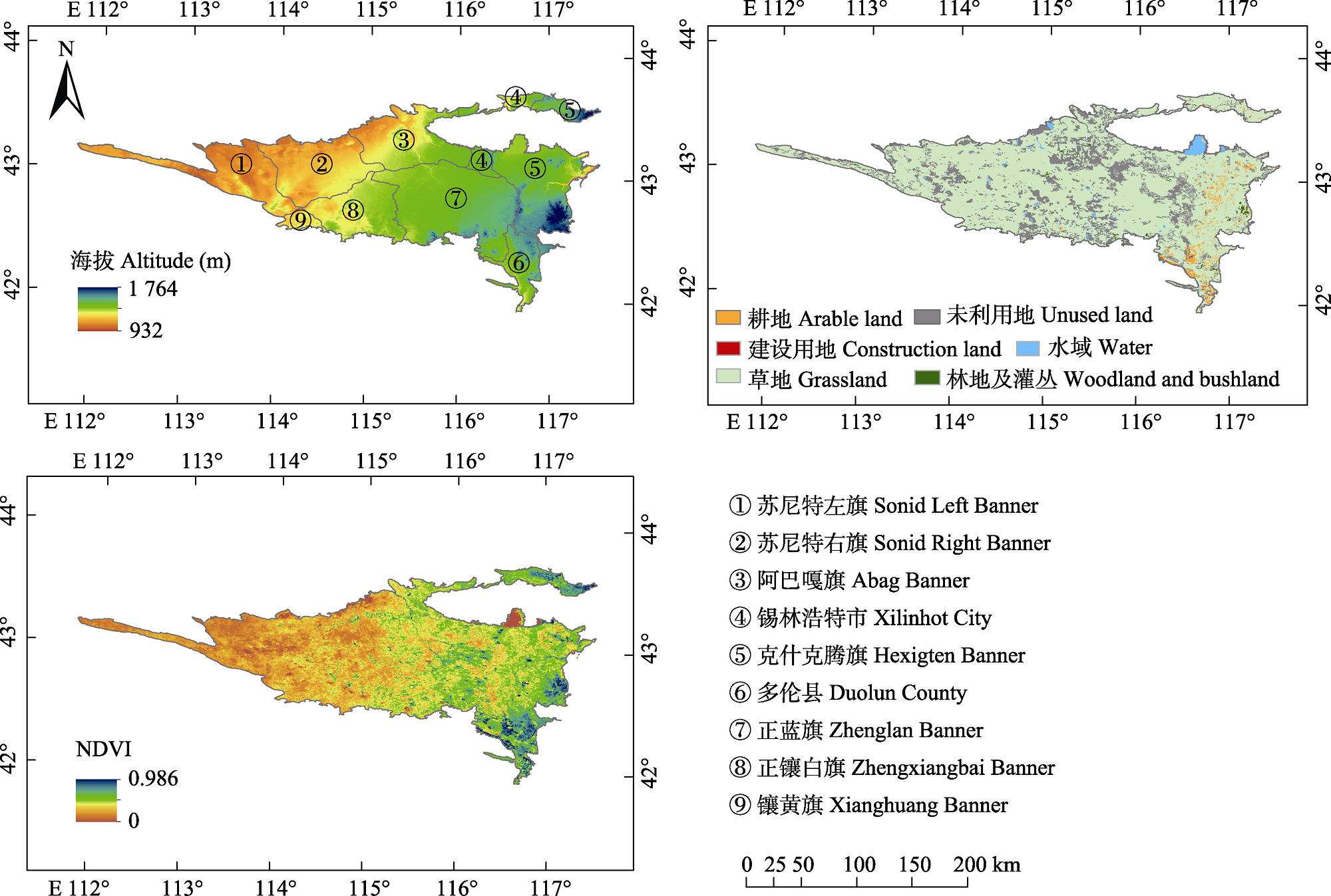
Fig. 1 Overview of altitude, land use and Normalized Difference Vegetation Index (NDVI) of the Hunshandake Sandy Land. The areas with NDVI of 0 in the figure are all non-vegetated areas.
| 数据类型 Data type | 空间分辨率 Spatial resolution (m) | 数据来源 Data source |
|---|---|---|
| 数字高程 Digital Elevation Model | 30 | 地理空间数据云 Geospatial Data Cloud ( |
| 土地利用类型 Land use type | 30 | 资源与环境科学数据平台 Chinese Resource and Environment Science Data Platform ( |
| 归一化植被指数 Normalized Difference Vegetation Index | 250 | 美国国家航空航天局(NASA)地球数据中心 NASA’s Earth Science Data Systems Program ( |
| 气象数据 Meteorological data | 250 | 中国国家气象中心 China Meteorological Data Service Centre ( |
| 土壤类型 Soil type | 1 000 | 联合国粮食及农业组织土壤数据 Harmonized World Soil Database ( |
| 人口 Population | 1 000 | LandScan全球人口数据 LandScan Population Data ( |
| 地区生产总值 Gross Domestic Product | 1 000 | 地理空间监测云平台 Geographical Information Monitoring Cloud Platform ( |
| 肉类总产量 Total meat production | - | 2021年锡林郭勒盟统计年鉴 Xilingol League Statistical Yearbook (2021) ( 2021年赤峰统计年鉴 Chifeng Statistical Yearbook (2021) ( |
Table 1 Data sources of the Hunshandake Sandy Land
| 数据类型 Data type | 空间分辨率 Spatial resolution (m) | 数据来源 Data source |
|---|---|---|
| 数字高程 Digital Elevation Model | 30 | 地理空间数据云 Geospatial Data Cloud ( |
| 土地利用类型 Land use type | 30 | 资源与环境科学数据平台 Chinese Resource and Environment Science Data Platform ( |
| 归一化植被指数 Normalized Difference Vegetation Index | 250 | 美国国家航空航天局(NASA)地球数据中心 NASA’s Earth Science Data Systems Program ( |
| 气象数据 Meteorological data | 250 | 中国国家气象中心 China Meteorological Data Service Centre ( |
| 土壤类型 Soil type | 1 000 | 联合国粮食及农业组织土壤数据 Harmonized World Soil Database ( |
| 人口 Population | 1 000 | LandScan全球人口数据 LandScan Population Data ( |
| 地区生产总值 Gross Domestic Product | 1 000 | 地理空间监测云平台 Geographical Information Monitoring Cloud Platform ( |
| 肉类总产量 Total meat production | - | 2021年锡林郭勒盟统计年鉴 Xilingol League Statistical Yearbook (2021) ( 2021年赤峰统计年鉴 Chifeng Statistical Yearbook (2021) ( |
| 阻力因子 Resistance factor | 阻力系数 Resistance coefficient | 权重 Weight | ||||
|---|---|---|---|---|---|---|
| 1 | 2 | 3 | 4 | 5 | ||
| 土地利用类型 Land use type | 草地、林地和灌丛 Grassland, woodland and bushland | 耕地 Arable land | 水体 Water | 未利用地 Unused land | 建设用地 Construction land | 0.30 |
| 温度 Temperature (℃) | 3.56-3.99 | 3.33-3.56 | 2.63-2.93 | 2.93-3.13 | 3.13-3.33 | 0.17 |
| 归一化植被指数 Normalized Difference Vegetation Index | 0.31-0.56 | 0.24-0.31 | 0.19-0.24 | 0.15-0.19 | 0-0.15 | 0.14 |
| 干旱指数 Aridity Index | 1.45-2.03 | 2.03-2.46 | 2.46-2.93 | 2.93-3.45 | 3.45-4.06 | 0.12 |
| 坡度 Slope (°) | 9.93-22.60 | 4.61-9.93 | 0-0.89 | 2.22-4.61 | 0.89-2.22 | 0.09 |
| 人口 Population | 0-27 | 27-114 | 114-281 | 281-560 | 560-971 | 0.09 |
| 海拔 Altitude (m) | 1 385-1 790 | 1 286-1 385 | 1 195-1 286 | 1 095-1 195 | 925-1 095 | 0.07 |
| 道路缓冲距离 Road buffer distance (km) | <1 | 1-2 | 2-3 | 3-4 | >4 | 0.02 |
Table 2 Ecological resistance surface of Hunshandake Sandy Land
| 阻力因子 Resistance factor | 阻力系数 Resistance coefficient | 权重 Weight | ||||
|---|---|---|---|---|---|---|
| 1 | 2 | 3 | 4 | 5 | ||
| 土地利用类型 Land use type | 草地、林地和灌丛 Grassland, woodland and bushland | 耕地 Arable land | 水体 Water | 未利用地 Unused land | 建设用地 Construction land | 0.30 |
| 温度 Temperature (℃) | 3.56-3.99 | 3.33-3.56 | 2.63-2.93 | 2.93-3.13 | 3.13-3.33 | 0.17 |
| 归一化植被指数 Normalized Difference Vegetation Index | 0.31-0.56 | 0.24-0.31 | 0.19-0.24 | 0.15-0.19 | 0-0.15 | 0.14 |
| 干旱指数 Aridity Index | 1.45-2.03 | 2.03-2.46 | 2.46-2.93 | 2.93-3.45 | 3.45-4.06 | 0.12 |
| 坡度 Slope (°) | 9.93-22.60 | 4.61-9.93 | 0-0.89 | 2.22-4.61 | 0.89-2.22 | 0.09 |
| 人口 Population | 0-27 | 27-114 | 114-281 | 281-560 | 560-971 | 0.09 |
| 海拔 Altitude (m) | 1 385-1 790 | 1 286-1 385 | 1 195-1 286 | 1 095-1 195 | 925-1 095 | 0.07 |
| 道路缓冲距离 Road buffer distance (km) | <1 | 1-2 | 2-3 | 3-4 | >4 | 0.02 |
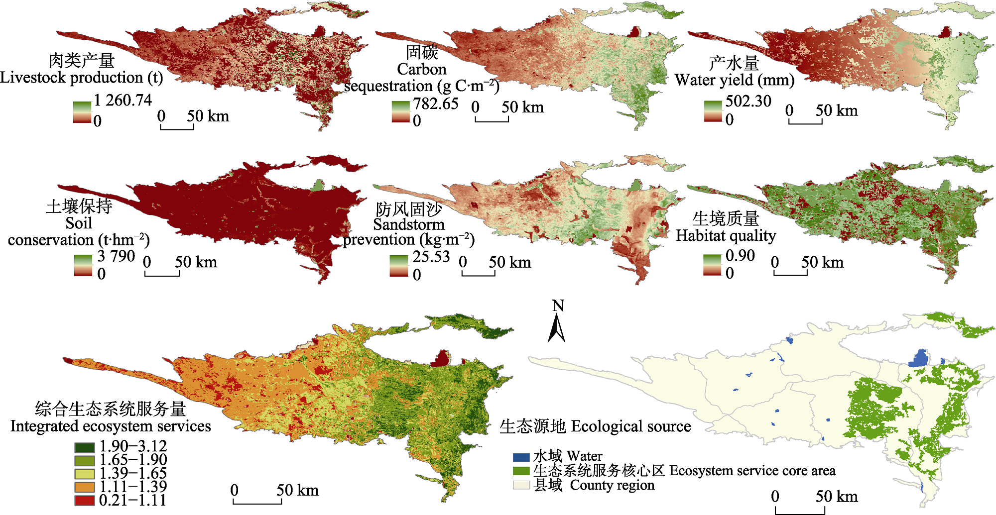
Fig. 2 Spatial distribution of ecosystem services and ecological source areas of Hunshandake Sandy Land.
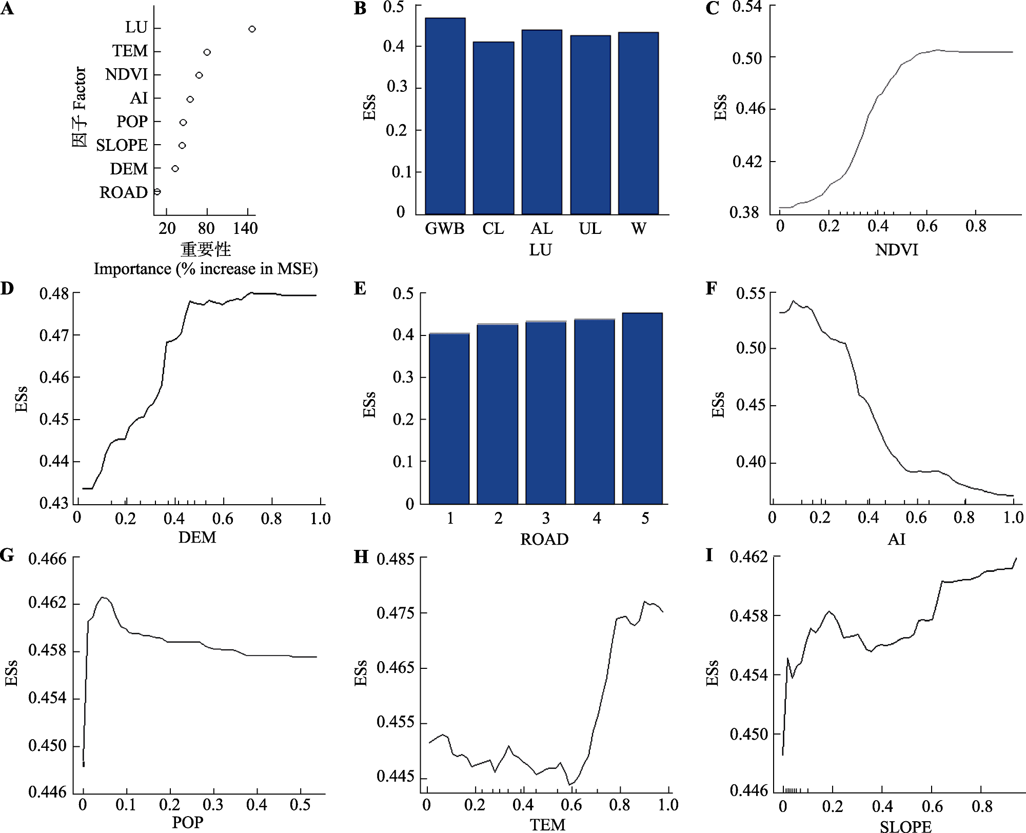
Fig. 3 Importance (A) and Partial Dependency Analysis Plot (B-I) of machine learning factors. AI, aridity index; DEM, elevation; ESs, integrated ecosystem services; LU, land use type; NDVI, normalized difference vegetation index; POP, population; ROAD, road buffer distance; SLOPE, slope; TEM, temperature. The above indices have been standardized. AL, arable land; CL, construction land; GWB, grassland, woodland and bushland; UL, unused land; W, water. MSE, mean squared error.
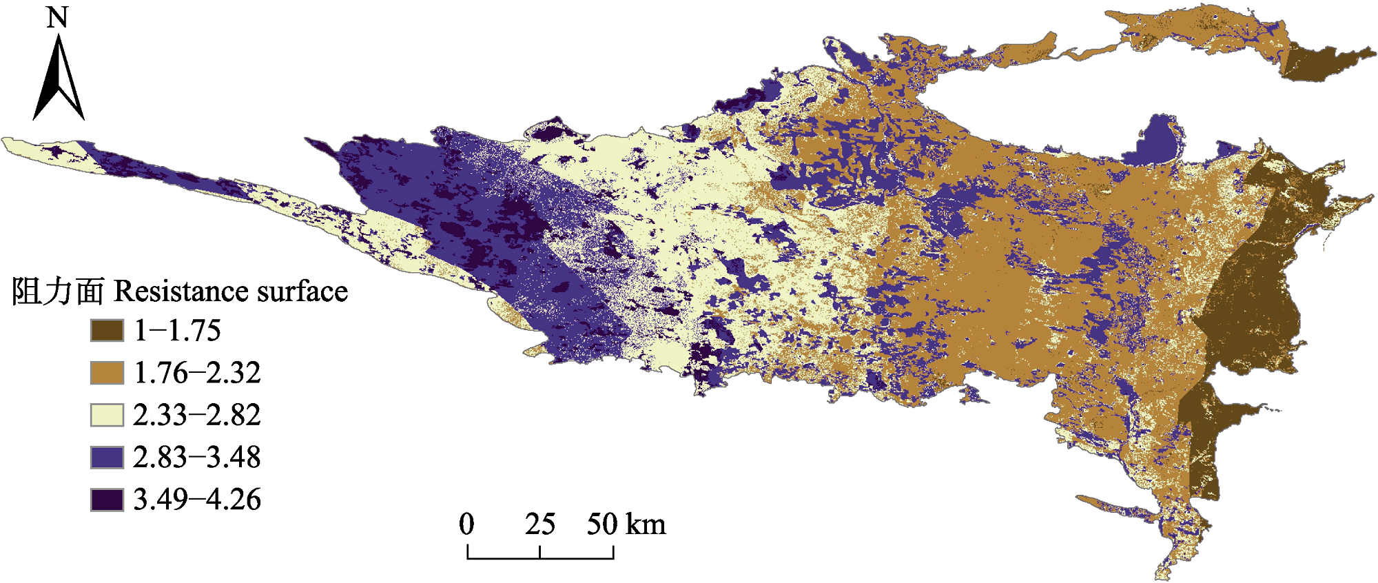
Fig. 4 Ecological security resistance surface of Hunshandake Sandy Land.
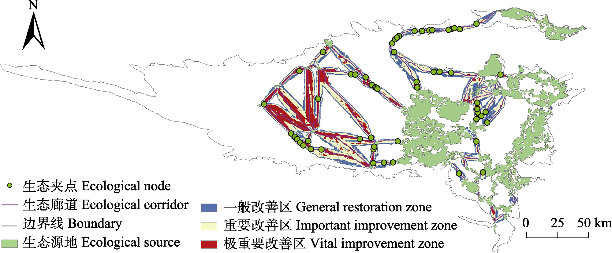
Fig. 5 Hunshandake Sandy Land’s ecological corridors and ecological points.
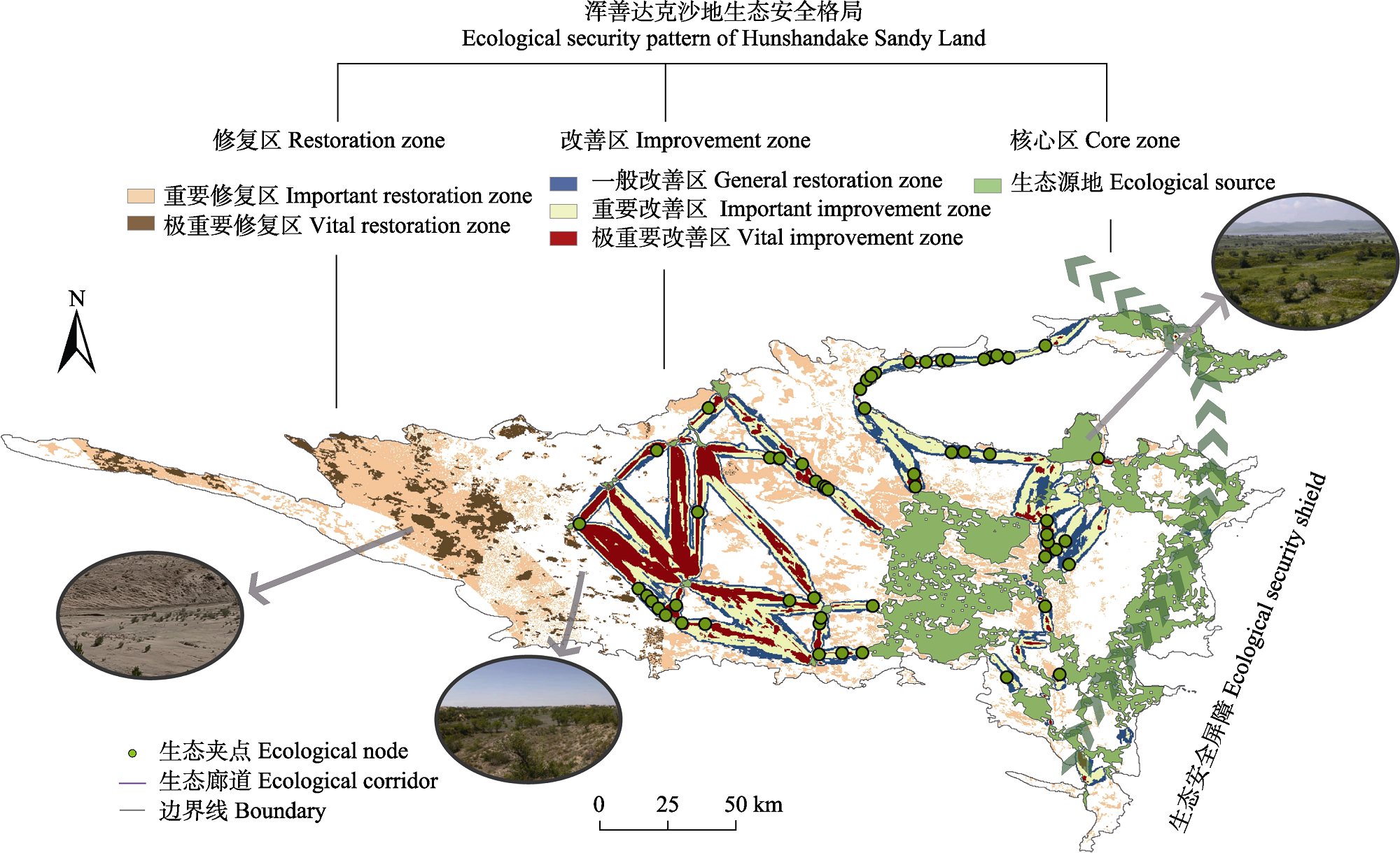
Fig. 6 Optimized zoning map of Hunshandake Sandy Land’s security pattern.
| [1] |
Berdugo M, Delgado-Baquerizo M, Soliveres S, Hernández- Clemente R, Zhao YC, Gaitán JJ, Gross N, Saiz H, Maire V, Lehmann A, Rillig MC, Solé RV, Maestre FT (2020). Global ecosystem thresholds driven by aridity. Science, 367, 787-790.
DOI PMID |
| [2] |
Chen ZQ, Zhang J, Zhang YL, Liu R (2021). Spatio-temporal patterns variation of ecological vulnerability in Otindag Sandy Land based on a vulnerability scoping diagram. Arid Zone Research, 38, 1464-1473.
DOI |
|
[陈臻琦, 张靖, 张贻龙, 刘睿 (2021). 基于VSD的近20 a来浑善达克沙地生态脆弱性变化研究. 干旱区研究, 38, 1464-1473.]
DOI |
|
| [3] | Dai LW, Tang HP, Zhang Q, Cui FQ (2020). The trade-off and synergistic relationship among ecosystem services: a case study in Duolun County, the agro-pastoral ecotone of Northern China. Acta Ecologica Sinica, 40, 2863-2876. |
| [戴路炜, 唐海萍, 张钦, 崔凤琪 (2020). 北方农牧交错带多伦县生态系统服务权衡与协同关系研究. 生态学报, 40, 2863-2876.] | |
| [4] |
Du XY, Lv FN, Wang CY, Yu ZR (2023). Construction of ecological network based on MSPA-Conefor-MCR at the county scale: a case study in Yanqing District, Beijing, China. Chinese Journal of Applied Ecology, 34, 1073-1082.
DOI |
|
[杜箫宇, 吕飞南, 王春雨, 宇振荣 (2023). 基于MSPA-Conefor-MCR的县域尺度生态网络构建——以延庆区为例. 应用生态学报, 34, 1073-1082.]
DOI |
|
| [5] | Fu BJ (2021). Four major scientific issues in the construction of the northern ecological security barrier. Man and the Biosphere, (1), 8-11. |
| [傅伯杰 (2021). 北方生态安全屏障建设的四大科学问题. 人与生物圈, (1), 8-11.] | |
| [6] | Fu BJ, Tian HQ, Tao FL, Zhao WW, Wang S (2020). Progress of the impact of global change on ecosystem services. China Basic Science, 22(3), 25-30. |
| [傅伯杰, 田汉勤, 陶福禄, 赵文武, 王帅 (2020). 全球变化对生态系统服务的影响研究进展. 中国基础科学, 22(3), 25-30.] | |
| [7] |
Ganasri BP, Ramesh H (2016). Assessment of soil erosion by RUSLE model using remote sensing and GIS—A case study of Nethravathi Basin. Geoscience Frontiers, 7, 953-961.
DOI URL |
| [8] | Gong GL, Liu X, Yao L, Ren LX, Wang M (2021). Improvement and application of wind factor in RWEQ model. Science of Soil and Water Conservation, 19(4), 143-148. |
| [巩国丽, 刘鑫, 要玲, 任丽霞, 王敏 (2021). RWEQ模型中风因子的改进及应用. 中国水土保持科学, 19(4), 143-148.] | |
| [9] | Han ZL, Zhao WZ, Yan XL, Zhong JQ, Meng QQ (2019). The evolution of ecological security pattern based on the profit and loss analysis of ecosystem services: taking Wafangdian County as a case. Acta Ecologica Sinica, 39, 8370-8382. |
| [韩增林, 赵文祯, 闫晓露, 钟敬秋, 孟琦琦 (2019). 基于生态系统服务价值损益的生态安全格局演变分析——以辽宁沿海瓦房店市为例. 生态学报, 39, 8370-8382.] | |
| [10] | Huang MD, Xiao Y, Qin KY, Gan S, Xie GD, Liu JY, Wang YY, Niu YN, Liu J (2022). Spatiotemporal dynamics and drivers of wind erosion prevention service in Otindag from 1980 to 2018. Acta Ecologica Sinica, 42, 7612-7629. |
| [黄孟冬, 肖玉, 秦克玉, 甘爽, 谢高地, 刘婧雅, 王洋洋, 牛樱楠, 刘佳 (2022). 1980-2018年浑善达克地区防风固沙服务时空变化及其驱动因素. 生态学报, 42, 7612-7629.] | |
| [11] | Li WJ, Kang JW, Wang Y (2023). Spatiotemporal changes and driving forces of ecological security in the Chengdu-Chongqing urban agglomeration, China: quantification using health-services-risk framework. Journal of Cleaner Production, 389, 136135. DOI: 10.1016/j.jclepro.2023.136135. |
| [12] | Liang KY, Jin XB, Zhang XL, Song JP, Li QQ, Ying SC, Qi Z, Zhou YK (2024). Construction of ecological security patterns coupling supply and demand of ecosystem services: a case study of Southern Jiangsu Province. Acta Ecologica Sinica, 44, 3880-3896. |
| [梁坤宇, 金晓斌, 张晓琳, 宋家鹏, 李权荃, 应苏辰, 祁曌, 周寅康 (2024). 耦合生态系统服务供需的生态安全格局构建——以苏南地区为例. 生态学报, 44, 3880-3896.] | |
| [13] | Luo Y, Chen DP, Luo XY, Yu H, Luo X (2024). Construction of ecological corridors in complex terrain areas based on the ‘cost-function-ecological benefit’ model. Ecological Indicators, 166, 112312. DOI: 10.1016/j.ecolind.2024.112312. |
| [14] | Ma KM, Fu BJ, Li XY, Guan WB (2004). The regional pattern for ecological security (RPES): the concept and theoretical basis. Acta Ecologica Sinica, 24, 761-768. |
| [马克明, 傅伯杰, 黎晓亚, 关文彬 (2004). 区域生态安全格局: 概念与理论基础. 生态学报, 24, 761-768.] | |
| [15] |
McRae BH, Dickson BG, Keitt TH, Shah VB (2008). Using circuit theory to model connectivity in ecology, evolution, and conservation. Ecology, 89, 2712-2724.
DOI PMID |
| [16] | Pan Y, Gong J, Yang JX, Yang T, Wang Y (2022). Construction of ecological security pattern based on ecological importance and connectivity of MSPA core area: a case study of Guijiang River Basin. China Land Science, 36(4), 86-95. |
| [潘越, 龚健, 杨建新, 杨婷, 王玉 (2022). 基于生态重要性和MSPA核心区连通性的生态安全格局构建——以桂江流域为例. 中国土地科学, 36, 86-95.] | |
| [17] |
Peng J, Pan YJ, Liu YX, Zhao HJ, Wang YL (2018a). Linking ecological degradation risk to identify ecological security patterns in a rapidly urbanizing landscape. Habitat International, 71, 110-124.
DOI URL |
| [18] |
Peng J, Yang Y, Liu YX, Hu YN, Du YY, Meersmans J, Qiu SJ (2018b). Linking ecosystem services and circuit theory to identify ecological security patterns. Science of the Total Environment, 644, 781-790.
DOI URL |
| [19] | Peng J, Zhao HJ, Liu YX, Wu JS (2017). Research progress and prospect on regional ecological security pattern construction. Geographical Research, 36, 407-419. |
|
[彭建, 赵会娟, 刘焱序, 吴健生 (2017). 区域生态安全格局构建研究进展与展望. 地理研究, 36, 407-419.]
DOI |
|
| [20] |
Peters MK, Hemp A, Appelhans T, Becker JN, Behler C, Classen A, Detsch F, Ensslin A, Ferger SW, Frederiksen SB, Gebert F, Gerschlauer F, Gütlein A, Helbig-Bonitz M, Hemp C, et al. (2019). Climate-land-use interactions shape tropical mountain biodiversity and ecosystem functions. Nature, 568, 88-92.
DOI |
| [21] | Sun LH, Liu H, Wang D, Hao HG (2022). Research on ecological security pattern construction based on the evaluation of ecosystem services and eco-environmental sensitivity. Research of Environmental Sciences, 35, 2508-2517. |
| [孙丽慧, 刘浩, 汪丁, 郝海广 (2022). 基于生态系统服务与生态环境敏感性评价的生态安全格局构建研究. 环境科学研究, 35, 2508-2517.] | |
| [22] | Tang Y, Zhu WP, Zhang H, Song Y (2015). A review on principle and application of the InVEST model. Ecological Science, 34, 204-208. |
| [唐尧, 祝炜平, 张慧, 宋瑜 (2015). InVEST模型原理及其应用研究进展. 生态科学, 34, 204-208.] | |
| [23] | Wang XQ, Wang BJ, Cui FQ (2024). Exploring ecosystem services interactions in the dryland: socio-ecological drivers and thresholds for better ecosystem management. Ecological Indicators, 159, 111699. DOI: 10.1016/j.ecolind.2024.111699. |
| [24] | Wang YL, Dong W, Zhang YL, Fu BJ, Zhao ZY, Lü YH, Zhang JJ, Wu X (2023). Research progress and prospects of ecological security based on ecosystem services. Acta Ecologica Sinica, 43, 7821-7829. |
| [王悦露, 董威, 张云龙, 傅伯杰, 赵正嫄, 吕一河, 张建军, 伍星 (2023). 基于生态系统服务的生态安全研究进展. 生态学报, 43, 7821-7829.] | |
| [25] | Xiao DN, Chen WB, Guo FL (2002). On the basic concepts and research contents of ecological security. Chinese Journal of Applied Ecology, 13, 354-358. |
| [肖笃宁, 陈文波, 郭福良 (2002). 论生态安全的基本概念和研究内容. 应用生态学报, 13, 354-358.] | |
| [26] | Xu J, Liao XK, Gan QX, Zhou MX (2023). Construction of ecological security pattern based on MSPA and circuit theory in Gansu section of the Yellow River Basin. Ecology and Environmental Sciences, 32, 805-813. |
|
[许静, 廖星凯, 甘崎旭, 周茅先 (2023). 基于MSPA与电路理论的黄河流域甘肃段生态安全格局构建. 生态环境学报, 32, 805-813.]
DOI |
|
| [27] |
Xu SN, Liu YF, Wang X, Zhang GX (2017). Scale effect on spatial patterns of ecosystem services and associations among them in semi-arid area: a case study in Ningxia Hui Autonomous Region, China. Science of the Total Environment, 598, 297-306.
DOI URL |
| [28] | Yin XW, Wu YP, Zhao WZ, Zhao FB, Sun PC, Song YN, Qiu LJ (2021). Drought characteristics and sensitivity of potential evapotranspiration to climatic factors in the arid and semi-arid areas of northwest China. Hydrogeology & Engineering Geology, 48(3), 20-30. |
| [阴晓伟, 吴一平, 赵文智, 赵富波, 孙彭成, 宋燕妮, 邱临静 (2021). 西北旱区潜在蒸散发的气候敏感性及其干旱特征研究. 水文地质工程地质, 48(3), 20-30.] | |
| [29] | Yong K (2008). Research on Feature Selection and Model Optimization Algorithm of Random Forest. Master degree dissertation, Harbin Institute of Technology, Harbin. |
| [雍凯 (2008). 随机森林的特征选择和模型优化算法研究. 硕士学位论文, 哈尔滨工业大学, 哈尔滨.] | |
| [30] | Zhang WJ (2008). Study on the Effect of Active Sand Barrier Vegetation and Soil Restoration in Horqin Sandy Land. PhD dissertation, Beijing Forestry University, Beijing. |
| [张文军 (2008). 科尔沁沙地活沙障植被及土壤恢复效应的研究. 博士学位论文, 北京林业大学, 北京.] | |
| [31] |
Zhang XR, Zhou J, Li MM (2020). Analysis on spatial and temporal changes of regional habitat quality based on the spatial pattern reconstruction of land use. Acta Geographica Sinica, 75, 160-178.
DOI |
|
[张学儒, 周杰, 李梦梅 (2020). 基于土地利用格局重建的区域生境质量时空变化分析. 地理学报, 75, 160-178.]
DOI |
|
| [32] |
Zhao XH, Han DC, Lu Q, Li YP, Zhang FM (2023). Spatiotemporal variations in ecological quality of Otindag Sandy Land based on a new modified remote sensing ecological index. Journal of Arid Land, 15, 920-939.
DOI |
| [33] | Zhou W, Shi JJ, Fan ZL (2023). Research on ecological protection of cultivated land based on food security and ecological security. China Land Science, 37(7), 125-134. |
| [周伟, 石吉金, 范振林 (2023). 基于粮食安全和生态安全的耕地生态保护研究. 中国土地科学, 37(7), 125-134.] | |
| [34] | Zhu LQ, Guo ZC, Xiao M, Qin MY, Xie YW (2022). Construction of county ecological security pattern in semi-arid area: a case study of Lintao County. Acta Ecologica Sinica, 42, 5799-5811. |
| [朱陇强, 郭泽呈, 肖敏, 秦梦谣, 颉耀文 (2022). 半干旱区县域生态安全格局构建——以临洮县为例. 生态学报, 42, 5799-5811.] | |
| [35] | Zhu WQ, Pan YZ, Zhang JS (2007). Estimation of net primary productivity of Chinese terrestrial vegetation based on remote sensing. Journal of Plant Ecology (Chinese Version), 31, 413-424. |
|
[朱文泉, 潘耀忠, 张锦水 (2007). 中国陆地植被净初级生产力遥感估算. 植物生态学报, 31, 413-424.]
DOI |
|
| [36] | Zou SJ, Zhang L, Huang X, Osei FB, Ou GL (2022). Early ecological security warning of cultivated lands using RF-MLP integration model: a case study on China’s main grain-producing areas. Ecological Indicators, 141, 109059. DOI: 10.1016/j.ecolind.2022.109059. |
| [37] | Zuo W, Zhou HZ, Wang Q (2003). Conceptual framework for selection of an indicator system for assessment of regional ecological safety. Soils, 35, 2-7. |
| [左伟, 周慧珍, 王桥 (2003). 区域生态安全评价指标体系选取的概念框架研究. 土壤, 35, 2-7.] |
| [1] | XU Meng-Zhen, LU Zheng-Kuan, TAN Xing-Ru, WANG Yan-Bing, SU Tian-Cheng, DOU Shan-De, PAN Qing-Min, CHEN Shi-Ping. Identification of key factors and construction of a rapid diagnostic indicator system for evaluation of grassland degradation in Hulun Buir meadow grasslands [J]. Chin J Plant Ecol, 2025, 49(1): 42-58. |
| [2] | JING Xin, HE Jin-Sheng. Relationship between biodiversity, ecosystem multifunctionality and multiserviceability: literature overview and research advances [J]. Chin J Plant Ecol, 2021, 45(10): 1094-1111. |
| [3] | BAI Yong-Fei, HUANG Jian-Hui, ZHENG Shu-Xia, PAN Qing-Min, ZHANG Li-Xia, ZHOU Hua-Kun, XU Hai-Liang, LI Yu-Lin, MA Jian. Drivers and regulating mechanisms of grassland and desert ecosystem services [J]. Chin J Plant Ecol, 2014, 38(2): 93-102. |
| [4] | XIAO Yu,XIE Gao-Di,AN Kai,LU Chun-Xia. A research framework of ecosystem services based on functional traits [J]. Chin J Plant Ecol, 2012, 36(4): 353-362. |
| [5] | XIE Gao_Di, XIAO Yu, LU Chun_Xia. STUDY ON ECOSYSTEM SERVICES: PROGRESS, LIMITATION AND BASIC PARADIGM [J]. Chin J Plant Ecol, 2006, 30(2): 191-199. |
| [6] | XIAO Yu, XIE Gao-Di, LU Chun-Xia, DING Xian-Zhong, LÜ Yao. THE IMPACT OF UREA AMENDMENTS ON ATMOSPHERIC GAS REGULATION SERVICES IN RICE PADDY ECOSYSTEMS AND THEIR VALUATION [J]. Chin J Plant Ecol, 2005, 29(4): 577-583. |
| [7] | JIANG Yan-Ling, ZHOU Guang-Sheng. Estimation of Ecosystem Services of Major Forest in China [J]. Chin J Plan Ecolo, 1999, 23(5): 426-432. |
| Viewed | ||||||
|
Full text |
|
|||||
|
Abstract |
|
|||||
Copyright © 2026 Chinese Journal of Plant Ecology
Tel: 010-62836134, 62836138, E-mail: apes@ibcas.ac.cn, cjpe@ibcas.ac.cn

