
Chin J Plant Ecol ›› 2020, Vol. 44 ›› Issue (6): 616-627.DOI: 10.17521/cjpe.2019.0267 cstr: 32100.14.cjpe.2019.0267
Special Issue: 生态遥感及应用
• Research Articles • Previous Articles Next Articles
YU Liang1,2, LI Jun-Li1,3,*( ), BAO An-Ming1,3, BAI Jie1,3, HUANG Yue1,3, LIU Tie1,3, SHEN Zhan-Feng4
Received:2019-10-15
Accepted:2020-02-24
Online:2020-06-20
Published:2020-04-30
Contact:
LI Jun-Li: ORCID:0000-0002-1054-5966, lijl@ms.xjb.ac.cn
Supported by:YU Liang, LI Jun-Li, BAO An-Ming, BAI Jie, HUANG Yue, LIU Tie, SHEN Zhan-Feng. Temporal areal changes of wetlands in the lower reaches of the Tarim River and their responses to ecological water conveyance[J]. Chin J Plant Ecol, 2020, 44(6): 616-627.
Add to citation manager EndNote|Ris|BibTeX
URL: https://www.plant-ecology.com/EN/10.17521/cjpe.2019.0267
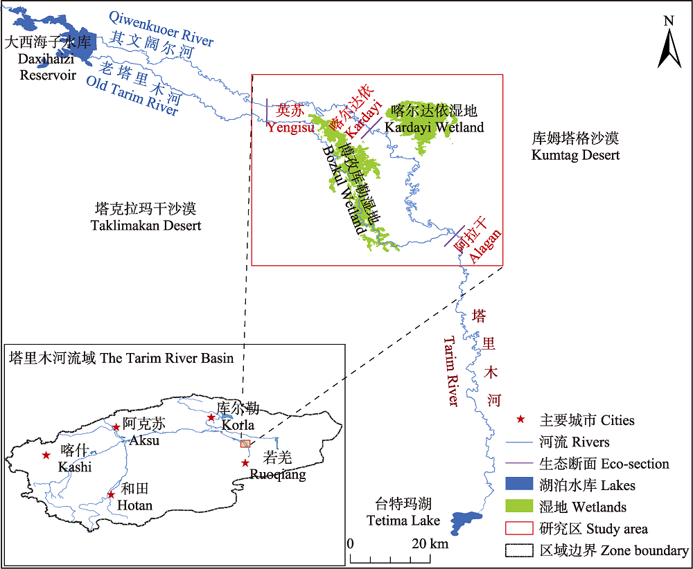
Fig. 1 Map of study area of the lower reaches of the Tarim River.
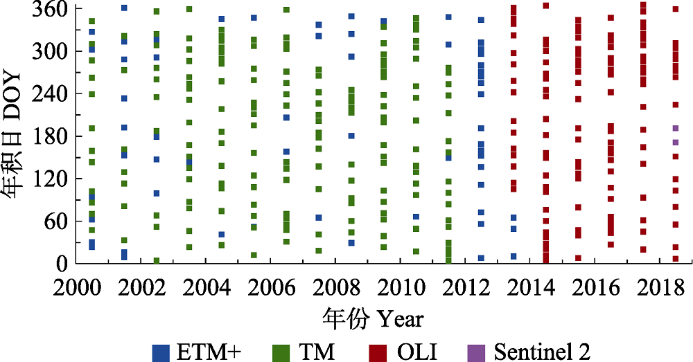
Fig. 2 Temporal distribution of multi-source remote sensing data in the study area of the lower reaches of the Tarim River during 2000-2018. DOY, day of year.
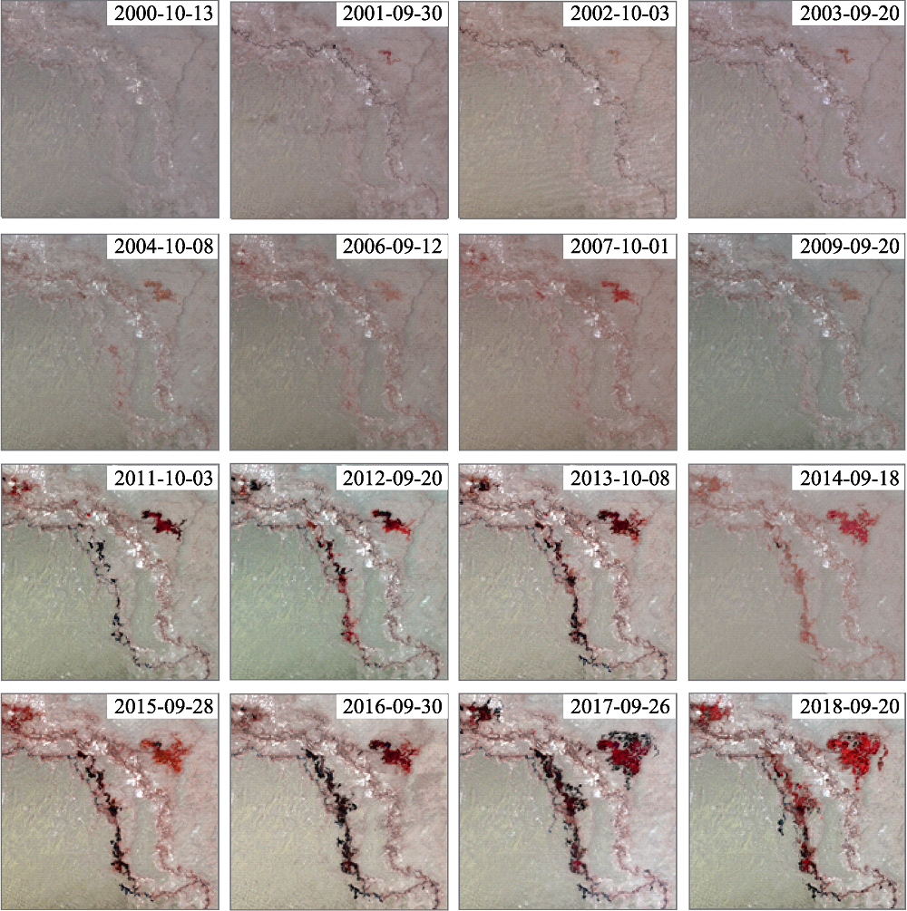
Fig. 3 Remote sensing maps of wetland dynamic in the study area of the lower reaches of the Tarim River during 2000-2018.
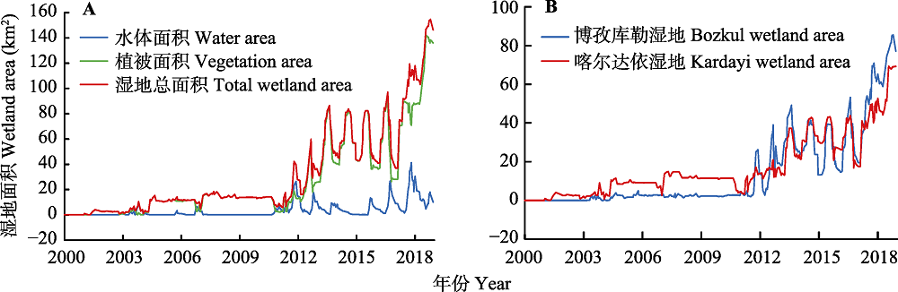
Fig. 4 Time series areal curves of total (A) and regional (B) wetland area of the lower reaches of the Tarim River during 2000-2018.
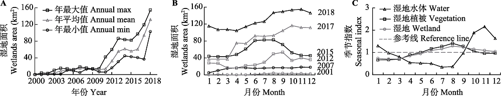
Fig. 5 Annual curve (A), monthly curve (B) and seasonal index (C) of the wetland areas of the lower reaches of the Tarim River.
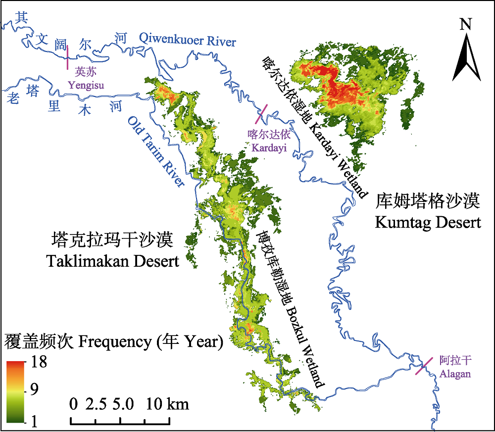
Fig. 6 Annual coverage frequency map of wetlands of the lower reaches of the Tarim River during 2000-2018.
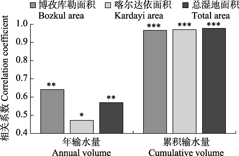
Fig. 7 Relations between wetland areas and ecological water conveyance volumes of the lower reaches of the Tarim River. *, p < 0.05; **, p < 0.01; ***, p < 0.001.
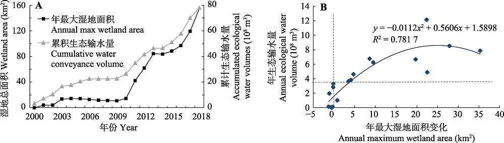
Fig. 8 Annual curve (A) and correlation curves (B) between annual maximum wetland area and accumulated ecological water volumes in the lower reaches of the Tarim River.
| 年份 Year | 单通道输水次数 Water conveyance times by single channel | 单通道输水量 Water conveyance volume by single channel (× 108 m3) | 双通道输水次数 Water conveyance times by dual channel | 双通道输水量 Water conveyance volume by dual channel (× 108 m3) | 博孜库勒湿地增长速率 Growth rate of Bozkul wetland area (km2·a-1) | 喀尔达依湿地增长速率 Growth rate of Kardayi wetland area (km2·a-1) |
|---|---|---|---|---|---|---|
| 2001-2009 | 6 | 11.66 | 3 | 11.04 | 0.28 | 1.15 |
| 2010-2013 | 1 | 0.14 | 4 | 23.57 | 11.58 | 6.45 |
| 2014-2014 | 1 | 0.07 | 1 | 0 | -3.88 | 2.75 |
| 2015-2018 | 0 | 0 | 4 | 30.58 | 11.56 | 6.54 |
Table 1 Relationships between ecological water volumes, conveyance pattern and wetland changing rates in the lower reaches of the Tarim River
| 年份 Year | 单通道输水次数 Water conveyance times by single channel | 单通道输水量 Water conveyance volume by single channel (× 108 m3) | 双通道输水次数 Water conveyance times by dual channel | 双通道输水量 Water conveyance volume by dual channel (× 108 m3) | 博孜库勒湿地增长速率 Growth rate of Bozkul wetland area (km2·a-1) | 喀尔达依湿地增长速率 Growth rate of Kardayi wetland area (km2·a-1) |
|---|---|---|---|---|---|---|
| 2001-2009 | 6 | 11.66 | 3 | 11.04 | 0.28 | 1.15 |
| 2010-2013 | 1 | 0.14 | 4 | 23.57 | 11.58 | 6.45 |
| 2014-2014 | 1 | 0.07 | 1 | 0 | -3.88 | 2.75 |
| 2015-2018 | 0 | 0 | 4 | 30.58 | 11.56 | 6.54 |
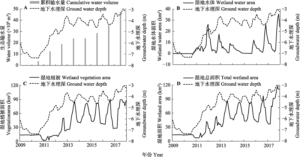
Fig. 9 Monthly curves between groundwater levels and accumulated water volumes (A), water areas (B), vegetation areas (C) and wetland areas (D) in the lower reaches of the Tarim River.
| 年份 Year | 滞后时间(月) Time lag (month) | ||
|---|---|---|---|
| 湿地水体 Wetland water | 湿地植被 Wetland vegetation | 湿地 Total wetland | |
| 2011 | -2 | 不显著 Not obvious | -2 |
| 2012 | -1 | 8 | -1 |
| 2013 | -1 | 8 | 8 |
| 2014 | 不显著 Not obvious | 8 | 8 |
| 2015 | -2 | 7 | 7 |
| 2016 | -4 | 7 | 7 |
| 2017 | 0 | 6 | 8 |
Table 2 Changes of time lag between wetland changes and groundwater depths in the lower reaches of the Tarim River
| 年份 Year | 滞后时间(月) Time lag (month) | ||
|---|---|---|---|
| 湿地水体 Wetland water | 湿地植被 Wetland vegetation | 湿地 Total wetland | |
| 2011 | -2 | 不显著 Not obvious | -2 |
| 2012 | -1 | 8 | -1 |
| 2013 | -1 | 8 | 8 |
| 2014 | 不显著 Not obvious | 8 | 8 |
| 2015 | -2 | 7 | 7 |
| 2016 | -4 | 7 | 7 |
| 2017 | 0 | 6 | 8 |
| [1] | Bai Y, Xu HL, Zhang QQ, Ye M (2015). Evaluation on ecological water requirement in the lower reaches of Tarim River based on groundwater restoration. Acta Ecologica Sinica, 35, 630-640. |
| [ 白元, 徐海量, 张青青, 叶茂 (2015). 基于地下水恢复的塔里木河下游生态需水量估算. 生态学报, 35, 630-640.] | |
| [2] | Chen MM, Liu JG (2015). Historical trends of wetland areas in the agriculture and pasture interlaced zone: a case study of the Huangqihai Lake Basin in northern China. Ecological Modelling, 318, 168-176. |
| [3] | Chen YN, Li WH, Chen YP, Xu CC, Zhang LH (2007). Water conveyance in dried-up riverway and ecological restoration in the lower reaches of Tarim River, China. Acta Ecologica Sinica, 27, 538-545. |
| [ 陈亚宁, 李卫红, 陈亚鹏, 徐长春, 张丽华 (2007). 新疆塔里木河下游断流河道输水与生态恢复. 生态学报, 27, 538-545.] | |
| [4] | Chen YN, Zilliacus H, Li WH, Zhang HF, Chen YP (2006). Ground-water level affects plant species diversity along the lower reaches of the Tarim River, Western China. Journal of Arid Environments, 66, 231-246. |
| [5] | Cleveland RB, Cleveland WS, McRae JE, Terpenning I (1990). STL: a seasonal-trend decomposition procedure based on loess. Journal of Official Statistics, 6, 3-73. |
| [6] | Ding MJ, Zhang YL, Liu LS, Wang ZF, Yang XC (2010). Seasonal time lag response of NDVI to temperature and precipitation change and its spatial characteristics in Tibetan Plateau. Progress in Geography, 29, 507-512. |
| [ 丁明军, 张镱锂, 刘林山, 王兆锋, 杨续超 (2010). 青藏高原植被覆盖对水热条件年内变化的响应及其空间特征. 地理科学进展, 29, 507-512.] | |
| [7] | Enzel Y, Bookman R, Sharon D, Gvirtzman H, Dayan U, Ziv B, Stein M (2003). Late Holocene climates of the Near East deduced from Dead Sea level variations and modern regional winter rainfall. Quaternary Research, 60, 263-273. |
| [8] | Fang QQ, Wang GQ, Liu TX, Xue BL, A YL (2018). Controls of carbon flux in a semi-arid grassland ecosystem experiencing wetland loss: vegetation patterns and environmental variables. Agricultural and Forest Meteorology, 259, 196-210. |
| [9] | Guo H, Huang Y, Li XY, Bao AM, Song Y, Meng FH (2016). Dynamic changes of fractional vegetation cover along the mainstream of the Tarim River. Journal of Desert Research, 36, 1472-1480. |
| [ 郭辉, 黄粤, 李向义, 包安明, 宋洋, 孟凡浩 (2016). 基于多尺度遥感数据的塔里木河干流地区植被覆盖动态. 中国沙漠, 36, 1472-1480.] | |
| [10] | Hanati G, Wang GY, Zhang Y, Liu QQ, Su LT (2018). Influence mechanism of intermittent ecological water conveyance on groundwater level and vegetation in arid land. Arid Land Geography, 41, 726-733. |
| [ 古力米热·哈那提, 王光焰, 张音, 刘迁迁, 苏里坦 (2018). 干旱区间歇性生态输水对地下水位与植被的影响机理研究. 干旱区地理, 41, 726-733.] | |
| [11] |
Hao XM, Chen YN, Li WH (2009). Indicating appropriate groundwater tables for desert river-bank forest at the Tarim River, Xinjiang, China. Environmental Monitoring and Assessment, 152, 167-177.
DOI URL PMID |
| [12] | Hao XM, Chen YN, Xu CC, Li WH (2008). Impacts of climate change and human activities on the surface runoff in the Tarim River Basin over the last fifty years. Water Resources Management, 22, 1159-1171. |
| [13] | Hao XM, Li WH (2014). Impacts of ecological water conveyance on groundwater dynamics and vegetation recovery in the lower reaches of the Tarim River in northwest China. Environmental Monitoring and Assessment, 186, 7605-7616. |
| [14] | Hao XM, Li WH, Chen YN (2008). Water table and the desert riparian forest community in the lower reaches of Tarim River, China. Journal of Plant Ecology (Chinese Version), 32, 838-847. |
| [ 郝兴明, 李卫红, 陈亚宁 (2008). 新疆塔里木河下游荒漠河岸(林)植被合理生态水位. 植物生态学报, 32, 838-847.] | |
| [15] | Huang Y, Bao AM, Wang SF, Wang YQ, Duan YB (2013). Eco-environmental change in the lower Tarim River under the influence of intermittent water transport. Acta Geographica Sinica, 68, 1251-1262. |
| [ 黄粤, 包安明, 王士飞, 王永琴, 段远彬 (2013). 间歇性输水影响下的2001-2011年里木河下游生态环境变化. 地理学报, 68, 1251-1262.] | |
| [16] | Jenkins KM, Boulton AJ, Ryder DS (2005). A common parched future? Research and management of Australian arid-zone floodplain wetlands. Hydrobiologia, 552, 57-73. |
| [17] | Ji F, Ma YJ, Fan ZL (2001). Soil water regime inPopulus euphratica forest on the Tarim River Alluvial Plain. Acta Phytoecologica Sinica, 25, 17-21. |
| [ 季方, 马英杰, 樊自立 (2001). 塔里木河冲积平原胡杨林的土壤水分状况研究. 植物生态学报, 25, 17-21.] | |
| [18] | Jiang PH, Cheng L, Li MC, Zhao RF, Huang QH (2014). Analysis of landscape fragmentation processes and driving forces in wetlands in arid areas: a case study of the middle reaches of the Heihe River, China. Ecological Indicators, 46, 240-252. |
| [19] |
Jiapaer GL, Chen X, Bao AM (2009). Coverage extraction and up-scaling of sparse desert vegetation in arid area. Chinese Journal of Applied Ecology, 20, 2925-2934.
URL PMID |
|
[ 古丽•加帕尔, 陈曦, 包安明 (2009). 干旱区荒漠稀疏植被覆盖度提取及尺度扩展效应. 应用生态学报, 20, 2925-2934.]
PMID |
|
| [20] | Klein I, Dietz AJ, Gessner U, Galayeva A, Myrzakhmetov A, Kuenzer C (2014). Evaluation of seasonal water body extents in Central Asia over the past 27 years derived from medium-resolution remote sensing data. International Journal of Applied Earth Observation and Geoinformation, 26, 335-349. |
| [21] | Li LJ, Zhang XQ, Chen CQ, Shen MY (2018). Ecological effects of water conveyance on the lower reaches of Tarim River in recent twenty years. Arid Land Geography, 41, 238-247. |
| [ 李丽君, 张小清, 陈长清, 申梦阳 (2018). 近20 a塔里木河下游输水对生态环境的影响. 干旱区地理, 41, 238-247.] | |
| [22] | Li X, Zhao LX, Han WJ, Faouzi B, Washaya P, Zhang XB, Jin HZ, Wu CQ (2018). Evaluating Algeria’s social and economic development using a series of night-time light images between 1992 to 2012. International Journal of Remote Sensing, 39, 9228-9248. |
| [23] | Liang KY (1987). Application of remote sensing technology in Xinjiang Institute of Geography, Chinese Academy of Sciences. Arid Land Geography, 10, 26-27. |
| [ 梁匡一 (1987). 新疆地理所遥感技术应用研究. 干旱区地理, 10, 26-27.] | |
| [24] | Liu HX, Guan WK, Cao XM, Zhang P, Zhang HY, Wu TZ, Li ZP, Feng YM (2019). Seasonal analysis of wetland landscape in TarimPopulous euphratica Nature Reserve. Arid Land Geography, 42, 130-136. |
| [ 刘洪霞, 管文轲, 曹晓明, 张谱, 张和钰, 吴天忠, 李志鹏, 冯益明 (2019). 塔里木胡杨自然保护区湿地景观季相分析. 干旱区地理, 42, 130-136.] | |
| [25] | Micklin PP (1988). Desiccation of the Aral Sea: a water management disaster in the Soviet Union. Science, 241, 1170-1176. |
| [26] |
Petus C, Lewis M, White D (2013). Monitoring temporal dynamics of Great Artesian Basin wetland vegetation, Australia, using MODIS NDVI. Ecological Indicators, 34, 41-52.
DOI URL |
| [27] |
Shen H, Abuduwaili J, Ma L, Samat A (2019). Remote sensing- based land surface change identification and prediction in the Aral Sea bed, Central Asia. International Journal of Environmental Science and Technology, 16, 2031-2046.
DOI URL |
| [28] | Töyrä J, Pietroniro A (2005). Towards operational monitoring of a northern wetland using geomatics-based techniques. Remote Sensing of Environment, 97, 174-191. |
| [29] | Wang XY, Peng SZ, Xu HL, Ling HB, Yue JS (2019). Assessment of ecological service value based on biomass ofPopulus euphratica in the lower reaches of the Tarim River. Acta Ecologica Sinica, 39, 1441-1451. |
| [ 王希义, 彭淑贞, 徐海量, 凌红波, 岳俊生 (2019). 基于生物量的塔里木河下游胡杨(Populus euphratica)生态服务价值评估. 生态学报, 39, 1441-1451.] | |
| [30] | Wang ZC (2010). The changes of Lop Nur Lake and the disappearance of Loulan. Journal of Arid Land, 2, 295-303. |
| [31] | Xie ZY, Huete A, Ma XL, Restrepo-Coupe N, Devadas R, Clarke K, Lewis M (2016). Landsat and GRACE observations of arid wetland dynamics in a dryland river system under multi-decadal hydroclimatic extremes. Journal of Hydrology, 543, 818-831. |
| [32] | Xu HL, Song YD, Wang Q, Ai M (2004). The effect of groundwater level on vegetation in the middle and lower reaches of the Traim River, Xinjiang, China. Acta Phytoecologica Sinica, 28, 400-405. |
| [ 徐海量, 宋郁东, 王强, 艾合买提 (2004). 塔里木河中下游地区不同地下水位对植被的影响. 植物生态学报, 28, 400-405.] | |
| [33] | Xu HL, Ye M, Li JM (2009). The ecological characteristics of the riparian vegetation affected by river overflowing disturbance in the lower Tarim River. Environmental Geology, 58, 1749-1755. |
| [34] |
Xu HL, Ye M, Song YD, Chen YN (2007). The natural vegetation responses to the groundwater change resulting from ecological water conveyances to the lower tarim river. Environmental Monitoring and Assessment, 131, 37-48.
DOI URL PMID |
| [35] |
Ye ZX, Chen YN, Li WH, Yan Y (2009). Effect of the ecological water conveyance project on environment in the Lower Tarim River, Xinjiang, China. Environmental Monitoring and Assessment, 149, 9-17.
URL PMID |
| [36] | Yin LK, Li T (2005). Interspecific relationship analysis of desert riparian forest plant communities in the middle and lower reaches of the Tarim River. Acta Phytoecologica Sinica, 29, 226-234. |
| [ 尹林克, 李涛 (2005). 塔里木河中下游地区荒漠河岸林群落种间关系分析. 植物生态学报, 29, 226-234.] | |
| [37] | Zhao RF, Chen YN, Zhou HR, Li YQ, Qian YB, Zhang LH (2009). Assessment of wetland fragmentation in the Tarim River basin, western China. Environmental Geology, 57, 455-464. |
| [38] | Zhao RF, Xie ZL, Zhang LH, Zhu W, Li J, Liang D (2015). Assessment of wetland fragmentation in the middle reaches of the Heihe River by the type change tracker model. Journal of Arid Land, 7, 177-188. |
| [39] | Zhao RF, Zhou HR, Xiao DN, Qian YB, Zhou KF (2006). Changes of wetland landscape pattern in the middle and lower reaches of the Tarim River. Acta Ecologica Sinica, 26, 3470-3478. |
| [ 赵锐锋, 周华荣, 肖笃宁, 钱亦兵, 周可法 (2006). 塔里木河中下游地区湿地景观格局变化. 生态学报, 26, 3470-3478.] | |
| [40] | Zhou HR (2005). Prospect on multifunctional landscapes of marshes in arid areas. Arid Land Geography, 28, 16-20. |
| [ 周华荣 (2005). 干旱区湿地多功能景观研究的意义与前景分析. 干旱区地理, 28, 16-20.] | |
| [41] | Zhu CM, Li JL, Zhang X, Luo JC (2014). Wetlands information automatic extraction from high resolution remote sensing imagery based on object-oriented technology. Bulletin of Surveying and Mapping, (10), 23-28. |
| [ 朱长明, 李均力, 张新, 骆剑承 (2014). 面向对象的高分辨率遥感影像湿地信息分层提取. 测绘通报, (10), 23-28.] | |
| [42] | Zhu XC, Yuan GF, Shao MA, Yi XB, Du T (2015). Spatial pattern of riparian vegetation in desert of the lower Tarim River basin. Chinese Journal of Plant Ecology, 39, 1053-1061. |
| [ 朱绪超, 袁国富, 邵明安, 易小波, 杜涛 (2015). 塔里木河下游河岸带植被的空间结构特征. 植物生态学报, 39, 1053-1061.] |
| [1] | CHEN PengPeng, WU ShengLi, ZHANG Yan, XIAO JiaQi, HUANG LuRui, SHI HuiJie. Population Structure and Dynamics of Haloxylon ammodendron on Parabolic Dunes in the Ebinur Lake Basin [J]. , 2026, 50(预发表): 0-. |
| [2] | LI Xiao-Hua, LIU Jie, LI Dan-Dan, ZHANG Le-Hua. Population structure and dynamic characteristics of the endangered plant Rhododendron xiaoxidongense [J]. Chin J Plant Ecol, 2025, 49(11): 1844-1857. |
| [3] | BAI Xue, LI Yu-Jing, JING Xiu-Qing, ZHAO Xiao-Dong, CHANG Sha-Sha, JING Tao-Yu, LIU Jin-Ru, ZHAO Peng-Yu. Response mechanisms of millet and its rhizosphere soil microbial communities to chromium stress [J]. Chin J Plant Ecol, 2023, 47(3): 418-433. |
| [4] | Ya-Han CHEN, Zong-Qiang XIE. Effects of storage conditions on total carbon and nitrogen contents of soil and plant samples [J]. Chin J Plant Ecol, 2017, 41(6): 632-638. |
| [5] | BAI T. Jay, LIANG Ying-Quan. VEGETATION MONITORING AND TREND ANALYSIS: DISCUSSIONS ON QUANTITATIVE VEGETATION ECOLOGY [J]. Chin J Plant Ecol, 2008, 32(4): 967-976. |
| [6] | HAO Xing-Ming, LI Wei-Hong, and CHEN Ya-Ning. WATER TABLE AND THE DESERT RIPARIAN FOREST COMMUNITY IN THE LOWER REACHES OF TARIM RIVER, CHINA [J]. Chin J Plant Ecol, 2008, 32(4): 838-847. |
| [7] | GU Zhi-Hui, CHEN Jin, SHI Pei-Jun, XU Ming. CORRELATION ANALYSIS OF NDVI DIFFERENCE SERIES AND CLIMATE VARIABLES IN XILINGOLE STEPPE FROM 1983 TO 1999 [J]. Chin J Plant Ecol, 2005, 29(5): 753-765. |
| [8] | WU Cheng-Zhen, HONG Wei. A Proposed Multidimensional Time Series Model of Individual Age and Diameter in Tsuga longibracteata [J]. Chin J Plan Ecolo, 2002, 26(4): 403-407. |
| [9] | T. Jay BAI, HAO Dun-Yuan, Aqilatu. Application of the Multi-Dimensional Sphere Model in Rangeland Monitoring Data Analysis [J]. Chin J Plan Ecolo, 2001, 25(6): 687-692. |
| [10] | Liu Jinfu, Hong Wei. Tone Series Model of Individual Age and Diameter in Castanopsis kaowarumii population [J]. Chin J Plan Ecolo, 1999, 23(3): 283-288. |
| Viewed | ||||||
|
Full text |
|
|||||
|
Abstract |
|
|||||
Copyright © 2026 Chinese Journal of Plant Ecology
Tel: 010-62836134, 62836138, E-mail: apes@ibcas.ac.cn, cjpe@ibcas.ac.cn
![]()