
植物生态学报 ›› 2022, Vol. 46 ›› Issue (2): 148-161.DOI: 10.17521/cjpe.2021.0033
所属专题: 生态遥感及应用
文可1, 姚焕玫1,*( ), 龚祝清1, 纳泽林1, 韦毅明1, 黄以1, 陈华权1, 廖鹏任1, 唐丽萍2
收稿日期:2021-01-25
接受日期:2021-07-15
出版日期:2022-02-20
发布日期:2021-08-06
通讯作者:
姚焕玫
作者简介:(191723450@qq.com)基金资助:
WEN Ke1, YAO Huan-Mei1,*(), GONG Zhu-Qing1, NA Ze-Lin1, WEI Yi-Ming1, HUANG Yi1, CHEN Hua-Quan1, LIAO Peng-Ren1, TANG Li-Ping2
Received:2021-01-25
Accepted:2021-07-15
Online:2022-02-20
Published:2021-08-06
Contact:
YAO Huan-Mei
Supported by:摘要:
水淹状况是湿地植被动态的重要影响因素。该研究基于谷歌地球引擎(GEE)平台, 利用2000-03-01至2020-02-29所有覆盖研究区域的MODIS遥感影像数据, 分析20年间水淹频率(IF)、增强型植被指数(EVI)的时空变化以及湿地植被对IF变化的响应, 得出以下结论: (1) 20年来鄱阳湖水文节律发生了明显改变, 高IF (IF > 75%)水域面积呈现下降趋势, 从2000年1 435.3 km2下降至2019年的510.25 km2, 降幅为64.45%; (2)区域平均EVI呈显著上升趋势, 植被扩张主要集中在中部IF下降区域; (3)分析不同总水淹频率区域中平均EVI年际变化, 发现EVI与水淹状况的变化趋势相似, 2009年之后鄱阳湖水域面积萎缩趋势缓解, EVI增长速度出现下降; (4)鄱阳湖湿地植被主要沿水域面积萎缩方向扩张, 基于像元统计20年间IF与EVI的变化趋势, 发现它们在空间分布上高度吻合, 这种空间异质性进一步证实水淹状况起到调节植被动态变化的作用。
文可, 姚焕玫, 龚祝清, 纳泽林, 韦毅明, 黄以, 陈华权, 廖鹏任, 唐丽萍. 水淹频率变化对鄱阳湖增强型植被指数的影响. 植物生态学报, 2022, 46(2): 148-161. DOI: 10.17521/cjpe.2021.0033
WEN Ke, YAO Huan-Mei, GONG Zhu-Qing, NA Ze-Lin, WEI Yi-Ming, HUANG Yi, CHEN Hua-Quan, LIAO Peng-Ren, TANG Li-Ping. Influence of inundation frequency change on enhanced vegetation index of wetland vegetation in Poyang Lake, China. Chinese Journal of Plant Ecology, 2022, 46(2): 148-161. DOI: 10.17521/cjpe.2021.0033
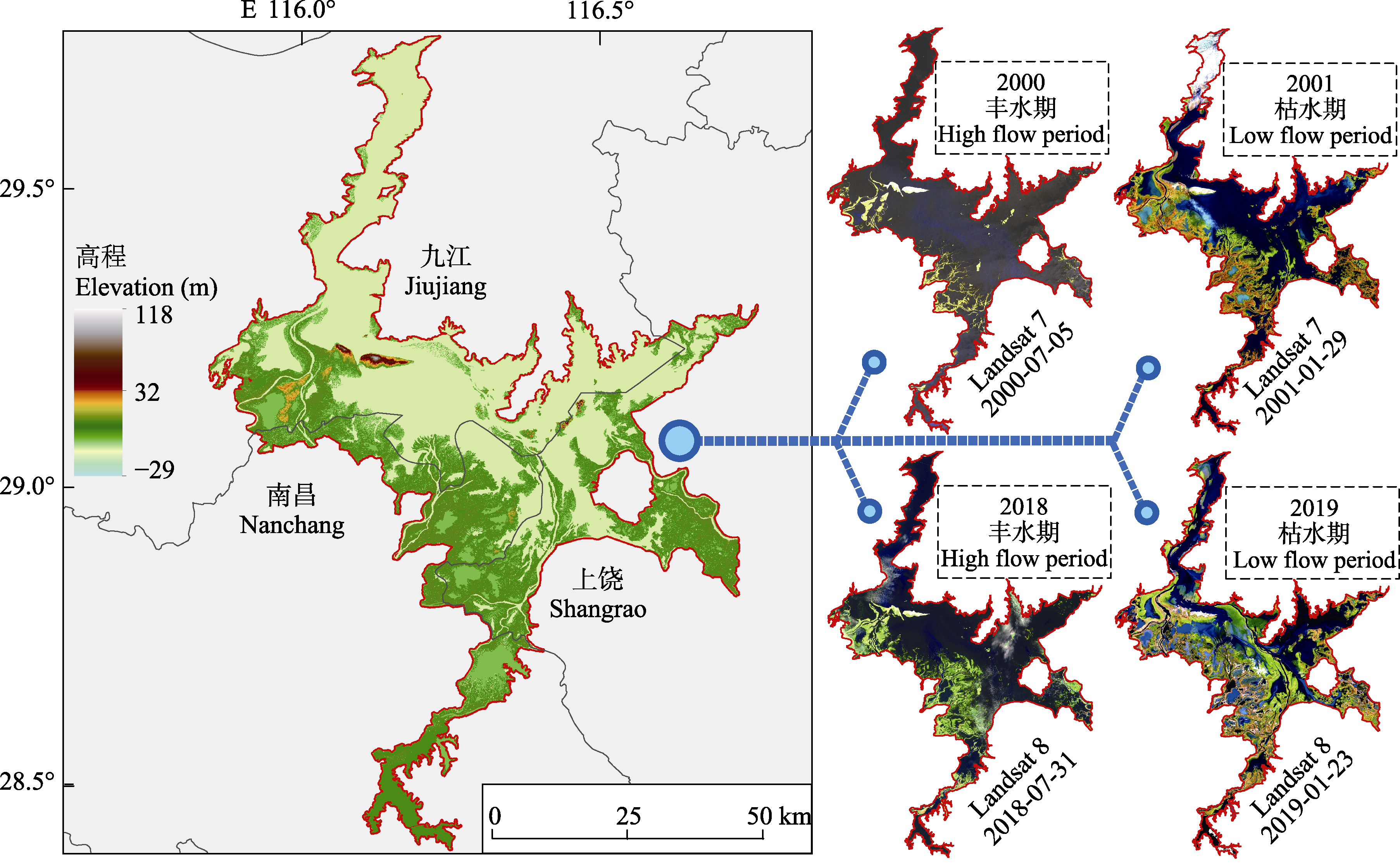
图1 鄱阳湖地理位置图。
Fig. 1 Location of Poyang Lake.
| 年份 Year | 日期 Date | 传感器 Sensor |
|---|---|---|
| 2000 | 2000-07-05 | Landsat 7-TM |
| 2001 | 2001-01-29 | Landsat 7-TM |
| 2005 | 2005-07-03 | Landsat 7-TM |
| 2006 | 2006-01-27 | Landsat 7-TM |
| 2010 | 2010-07-25 | Landsat 5-TM |
| 2011 | 2011-01-12 | HJ 1A-CCD |
| 2018 | 2018-07-31 | Landsat 8-OIL |
| 2019 | 2019-01-23 | Landsat 8-OIL |
表1 鄱阳湖2000-2019年30 m中分辨率影像
Table 1 Images with 30 m moderate resolution of Poyang Lake in 2000-2019
| 年份 Year | 日期 Date | 传感器 Sensor |
|---|---|---|
| 2000 | 2000-07-05 | Landsat 7-TM |
| 2001 | 2001-01-29 | Landsat 7-TM |
| 2005 | 2005-07-03 | Landsat 7-TM |
| 2006 | 2006-01-27 | Landsat 7-TM |
| 2010 | 2010-07-25 | Landsat 5-TM |
| 2011 | 2011-01-12 | HJ 1A-CCD |
| 2018 | 2018-07-31 | Landsat 8-OIL |
| 2019 | 2019-01-23 | Landsat 8-OIL |
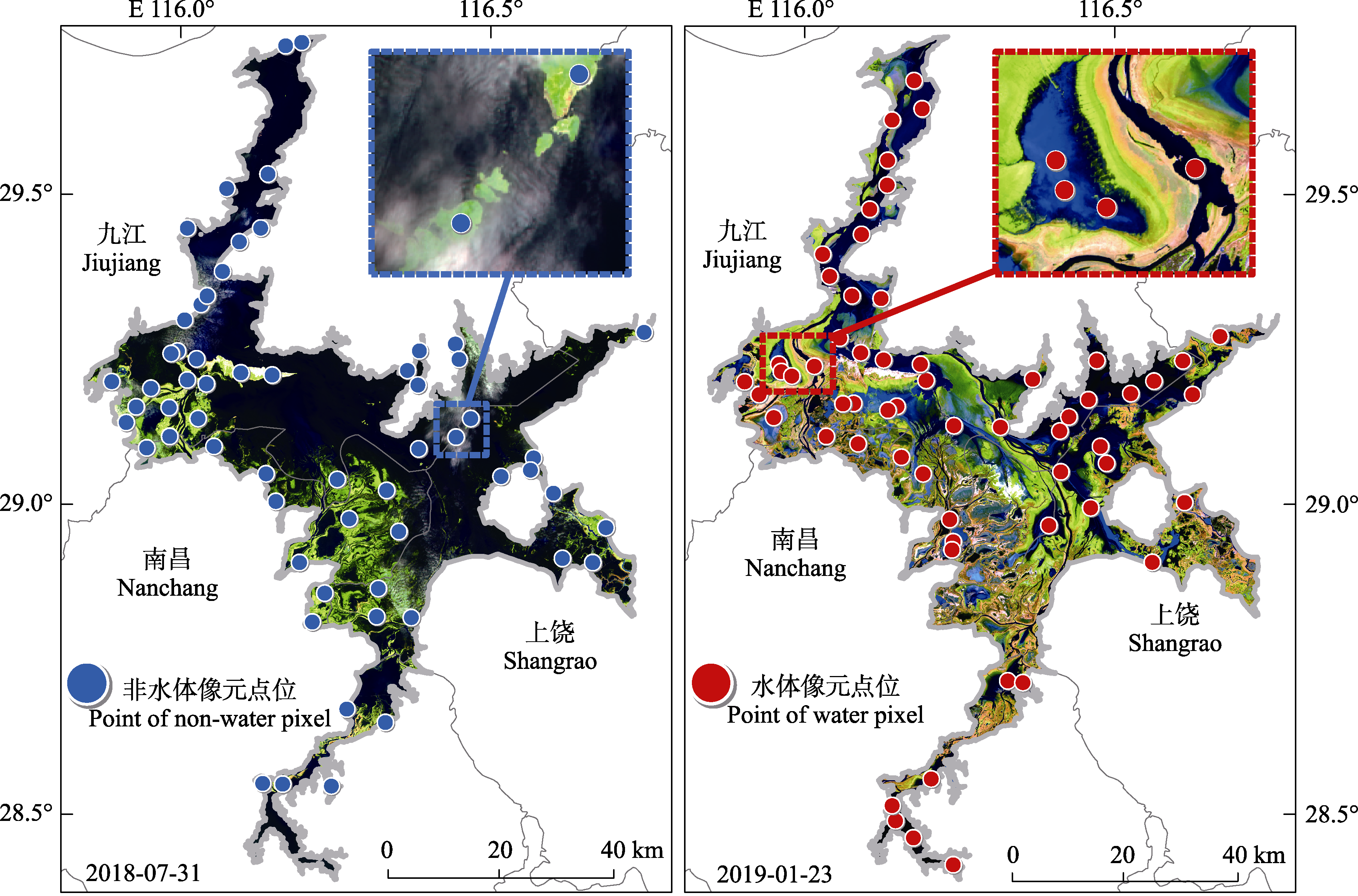
图2 鄱阳湖水体识别的训练样本分布图。
Fig. 2 Training samples distribution of water body recognition of Poyang Lake.
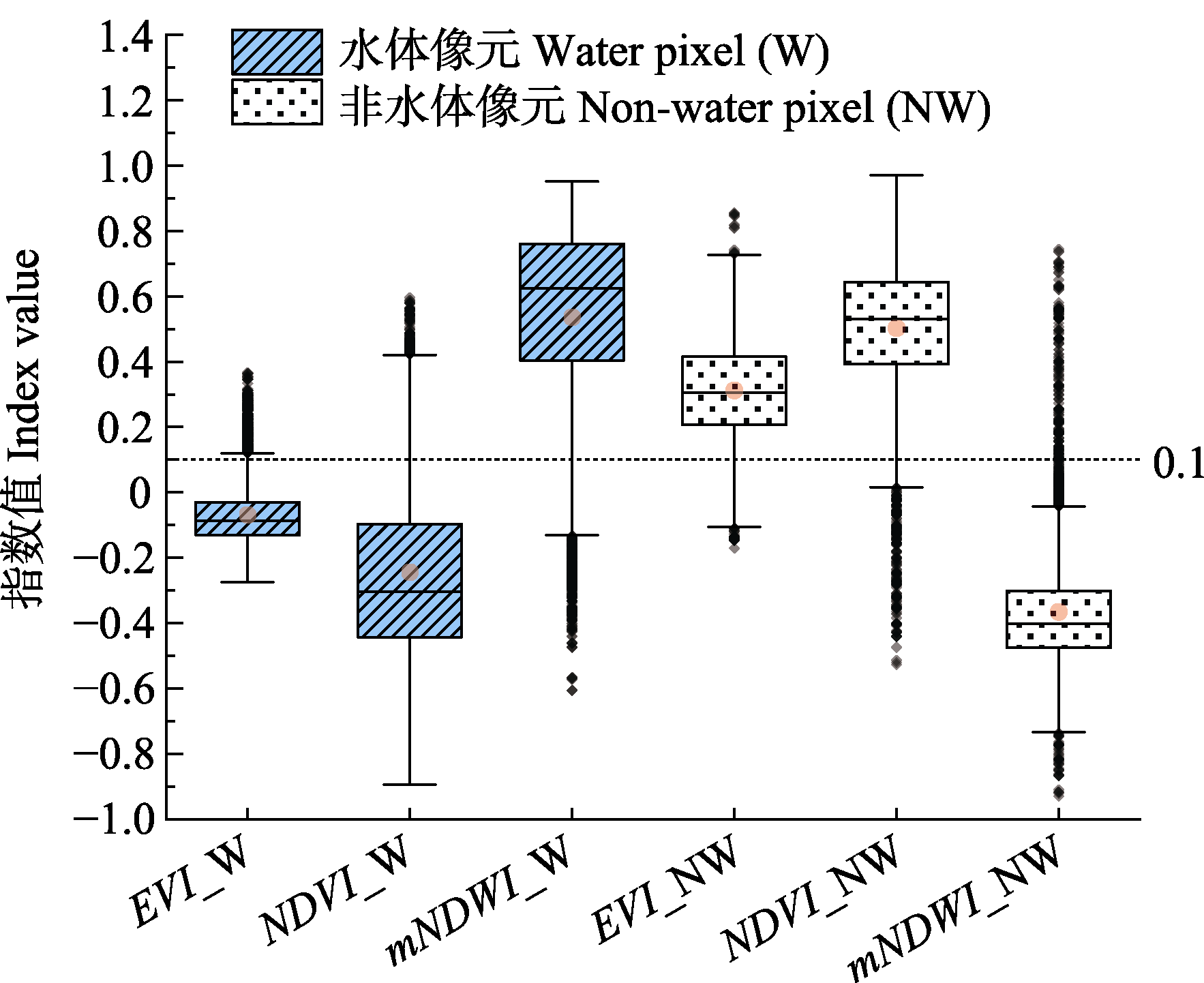
图3 鄱阳湖水体和非水体像元光谱指数的数值分布。EVI, 增强型植被指数; NDVI, 归一化植被指数; mNDWI, 改进的归一化差异水体指数。
Fig. 3 Numerical distribution of spectral indices of water pixel and non-water pixel of Poyang Lake. EVI, enhanced vegetation index; NDVI, normalized difference vegetation index; mNDWI, modified normalized difference water index.
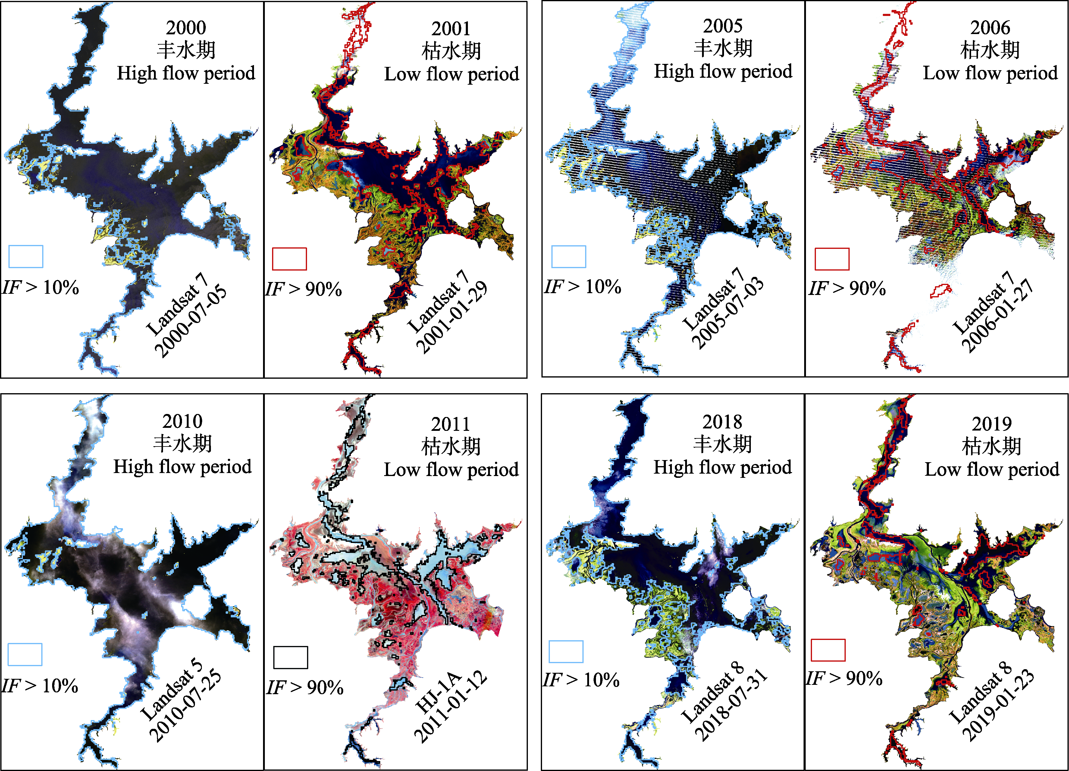
图4 鄱阳湖水淹频率(IF)准确性验证。
Fig. 4 Verification of inundation frequency (IF) accuracy of Poyang Lake.
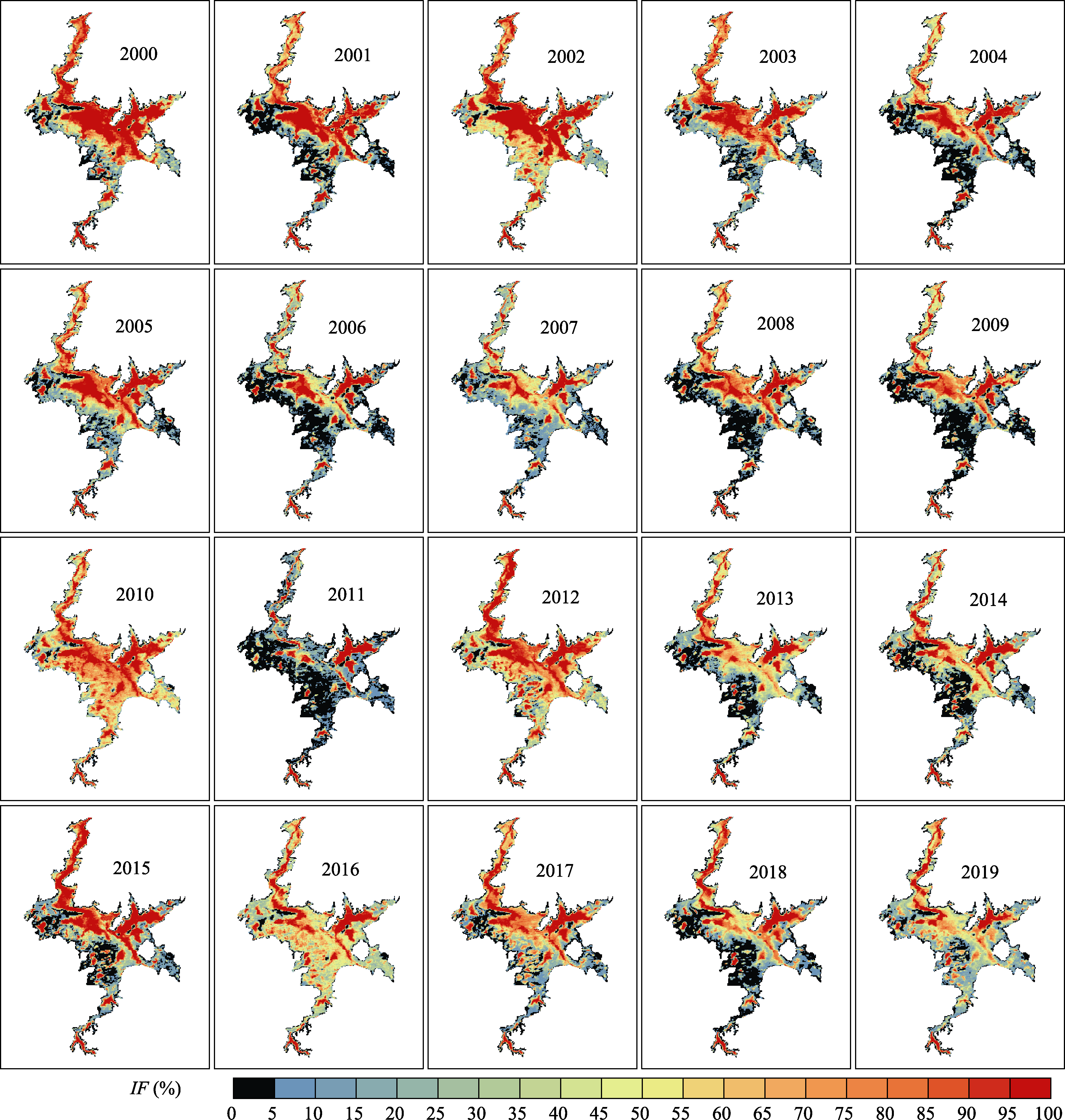
图5 2000-2019年鄱阳湖水淹频率(IF)空间分布图。
Fig. 5 Spatial distribution map of inundation frequency (IF) of Poyang Lake from 2000 to 2019.
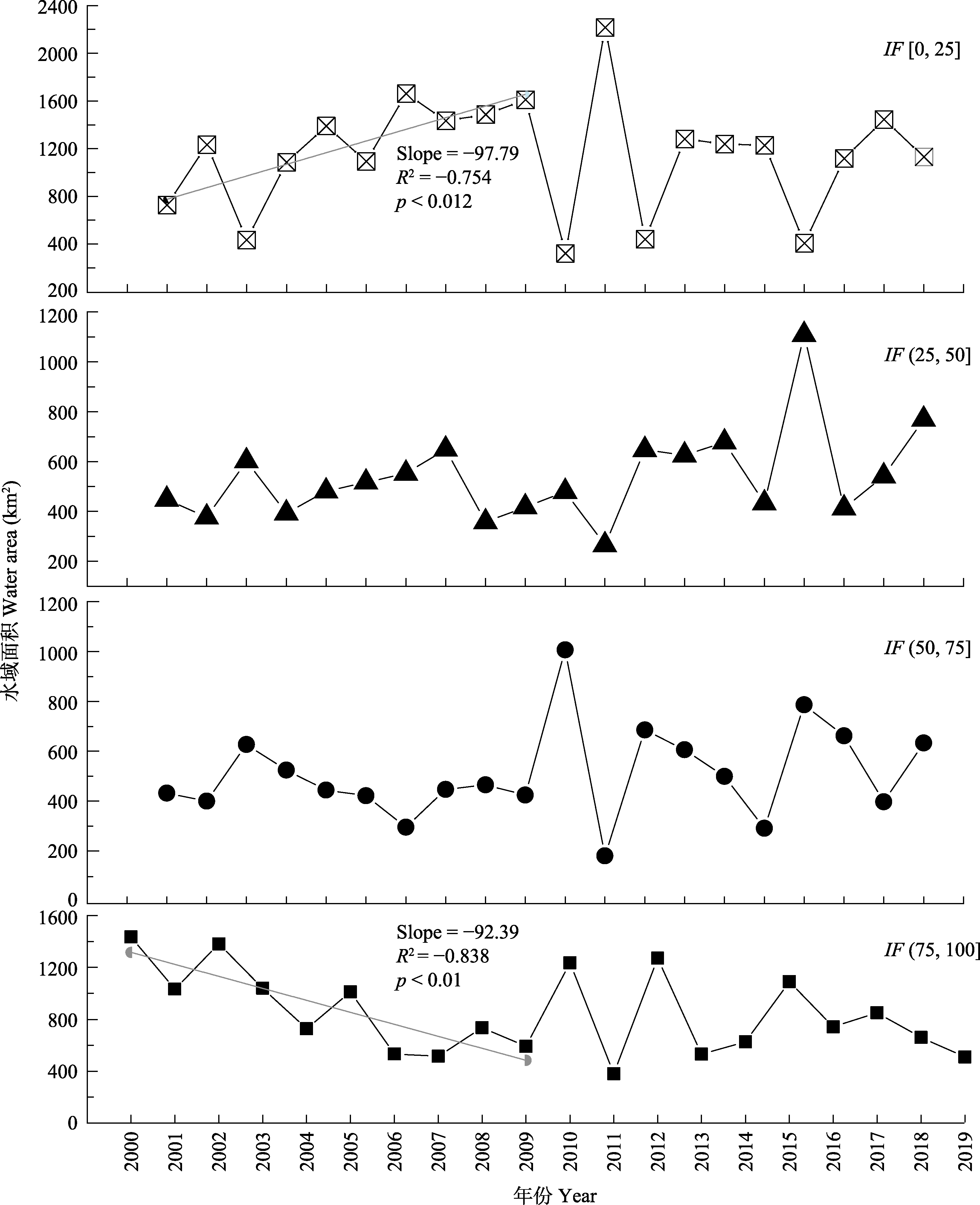
图6 2000-2019年鄱阳湖不同水淹频率(IF)区间的水域面积变化。
Fig. 6 Changes in the water area with inundation frequency (IF) of Poyang Lake in the different ranges from 2000 to 2019.
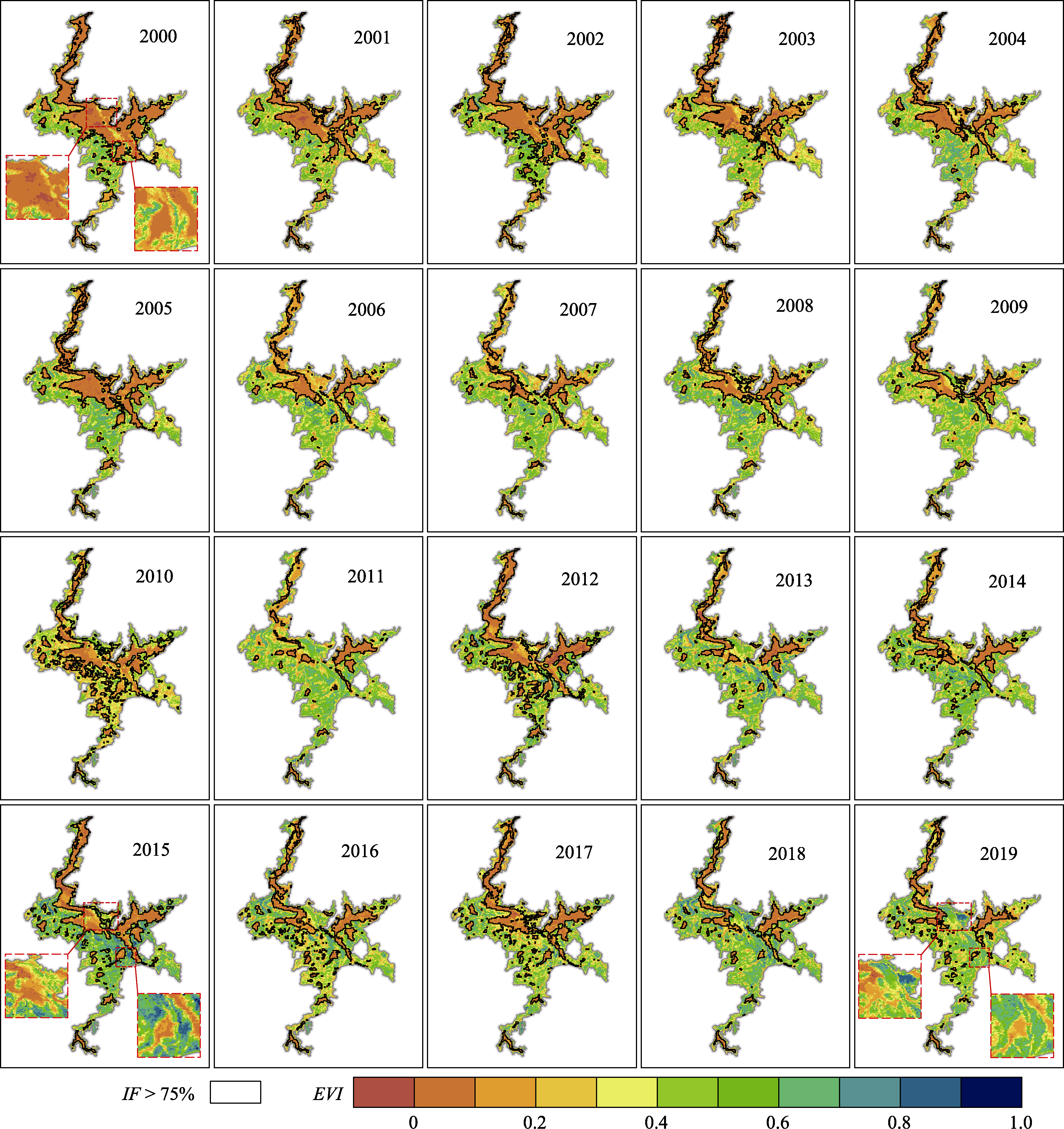
图7 2000-2019年鄱阳湖湿地植被增强型植被指数(EVI)时空变化。IF, 水淹频率。
Fig. 7 Spatial and temporal changes of enhanced vegetation index (EVI) of wetland vegetation in Poyang Lake from 2000 to 2019. IF, inundation frequency.
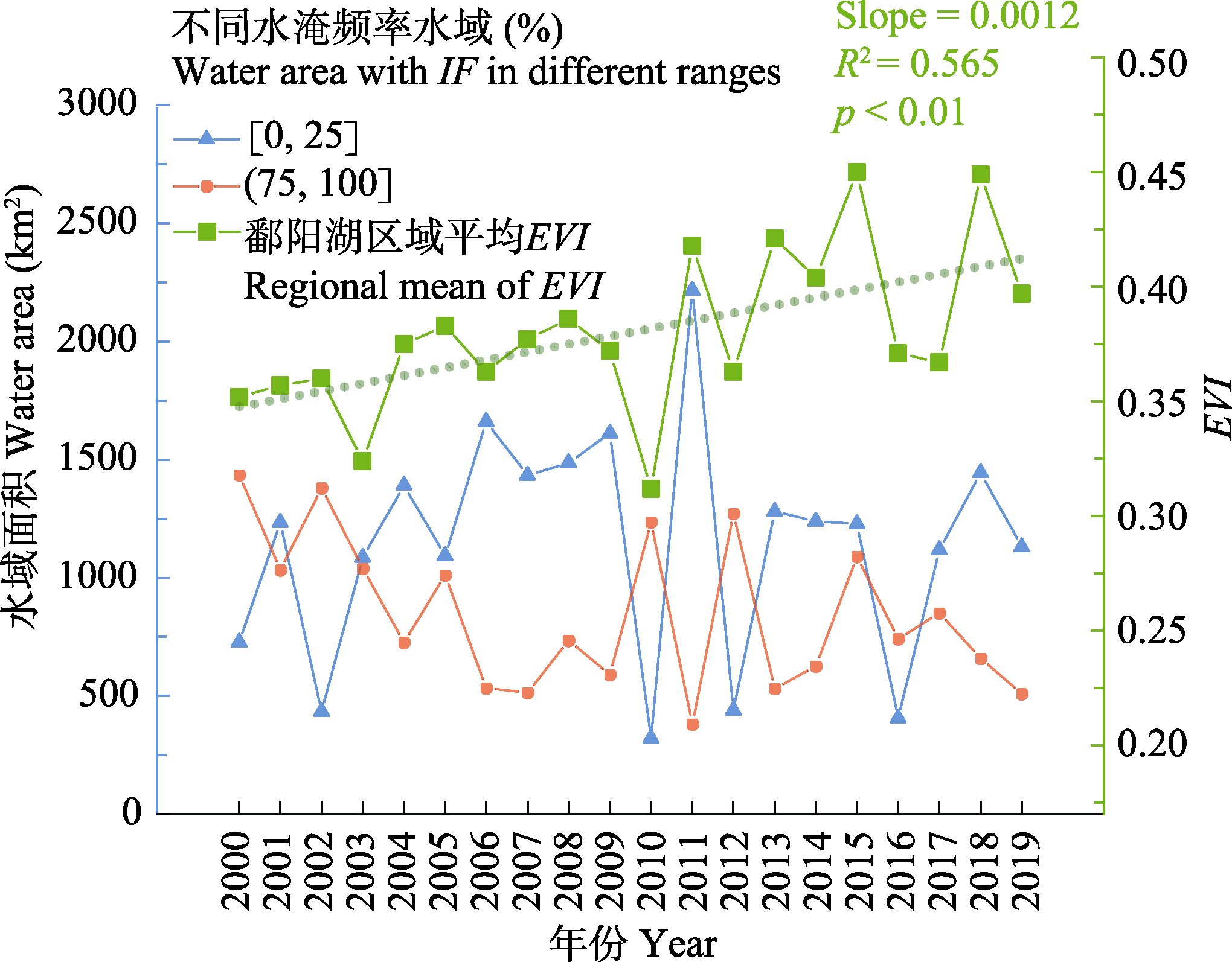
图8 2000-2019年鄱阳湖区域平均增强型植被指数(EVI)和高、低水淹频率水域面积变化。
Fig. 8 Change of regional mean enhanced vegetation index (EVI), and water area of high and low inundation frequency (IF) of Poyang Lake from 2000 to 2019.
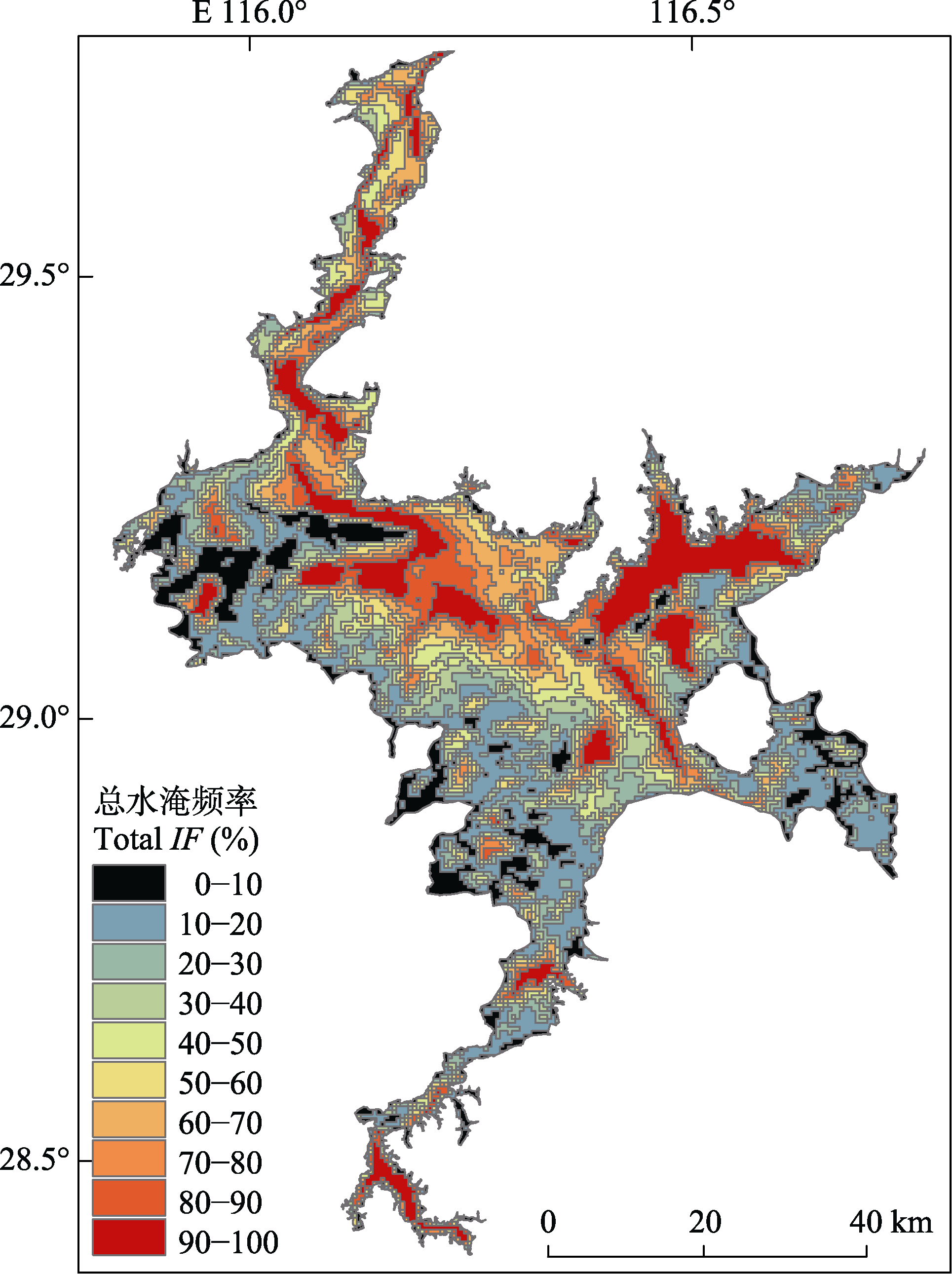
图9 2000-2019年鄱阳湖总水淹频率。
Fig. 9 Total inundation frequency (IF) of Poyang Lake during 2000-2019.
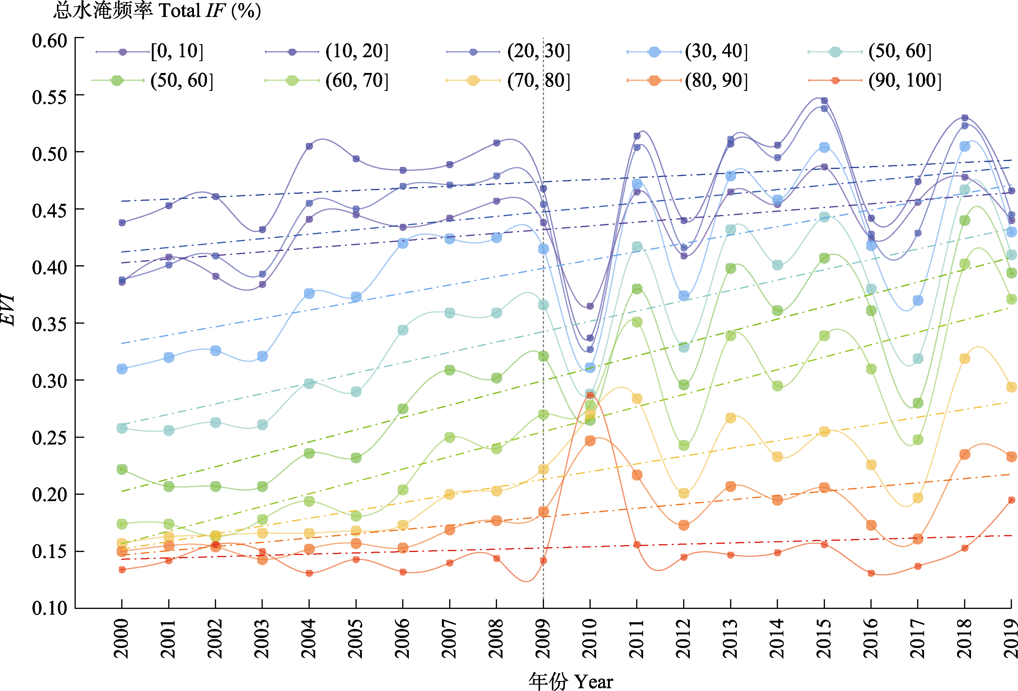
图10 鄱阳湖不同总水淹频率区域中平均增强型植被指数(EVI)年际变化(2000-2019)。
Fig. 10 Change of average enhanced vegetation index (EVI) in different total inundation frequency (IF) regions of Poyang Lake from 2000 to 2019.
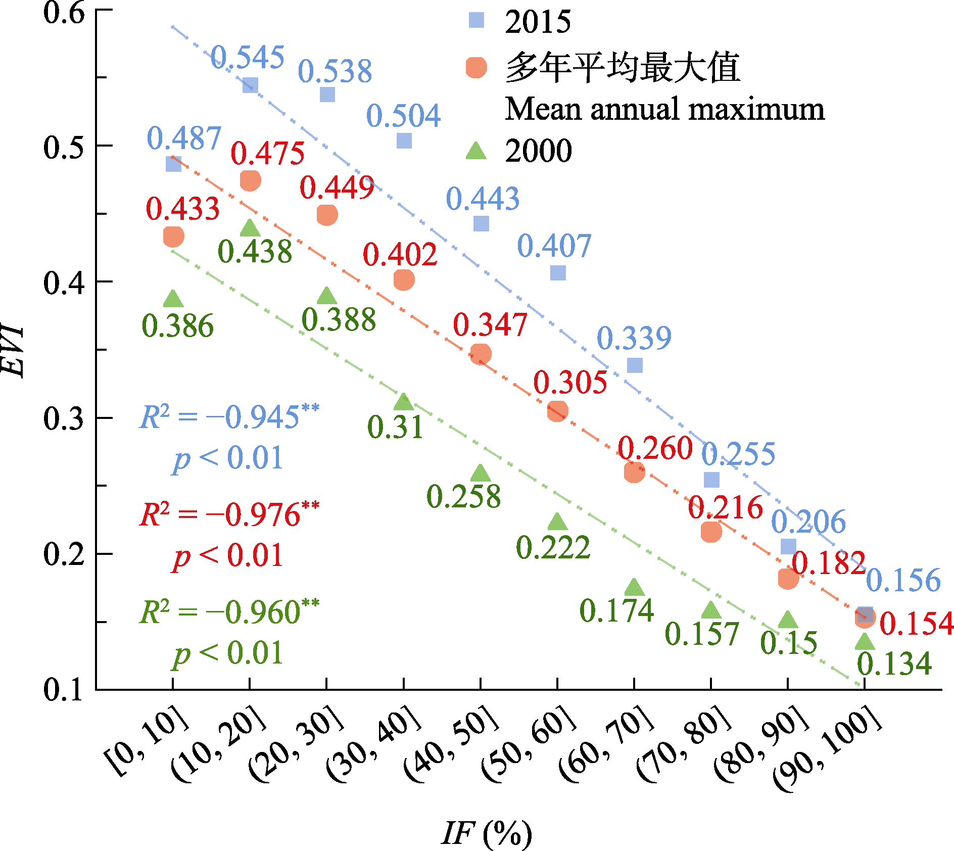
图11 鄱阳湖增强型植被指数(EVI)与总水淹频率(IF)关系。
Fig. 11 Relationship between the enhanced vegetation index (EVI) and the total inundation frequency (IF) of Poyang Lake.
| 年份 Year | 2000 | 2001 | 2002 | 2003 | 2004 | 2005 | 2006 | 2007 | 2008 | 2009 |
|---|---|---|---|---|---|---|---|---|---|---|
| R² | -0.960** | -0.953** | -0.933** | -0.952** | -0.962** | -0.958** | -0.96** | -0.969** | -0.972** | -0.974** |
| p | <0.01 | <0.01 | <0.01 | <0.01 | <0.01 | <0.01 | <0.01 | <0.01 | <0.01 | <0.01 |
| 年份 Year | 2010 | 2011 | 2012 | 2013 | 2014 | 2015 | 2016 | 2017 | 2018 | 2019 |
| R² | -0.870** | -0.946** | -0.979** | -0.938** | -0.956** | -0.945** | -0.943** | -0.991** | -0.903** | -0.927** |
| p | <0.01 | <0.01 | <0.01 | <0.01 | <0.01 | <0.01 | <0.01 | <0.01 | <0.01 | <0.01 |
表2 鄱阳湖年最大增强型植被指数(EVI)与总水淹频率(IF)的Pearson相关系数(2000-2019)
Table 2 Pearson correlation coefficient between annual maximum enhanced vegetation index (EVI) and total inundation frequency (IF) of Poyang Lake (2000-2019)
| 年份 Year | 2000 | 2001 | 2002 | 2003 | 2004 | 2005 | 2006 | 2007 | 2008 | 2009 |
|---|---|---|---|---|---|---|---|---|---|---|
| R² | -0.960** | -0.953** | -0.933** | -0.952** | -0.962** | -0.958** | -0.96** | -0.969** | -0.972** | -0.974** |
| p | <0.01 | <0.01 | <0.01 | <0.01 | <0.01 | <0.01 | <0.01 | <0.01 | <0.01 | <0.01 |
| 年份 Year | 2010 | 2011 | 2012 | 2013 | 2014 | 2015 | 2016 | 2017 | 2018 | 2019 |
| R² | -0.870** | -0.946** | -0.979** | -0.938** | -0.956** | -0.945** | -0.943** | -0.991** | -0.903** | -0.927** |
| p | <0.01 | <0.01 | <0.01 | <0.01 | <0.01 | <0.01 | <0.01 | <0.01 | <0.01 | <0.01 |
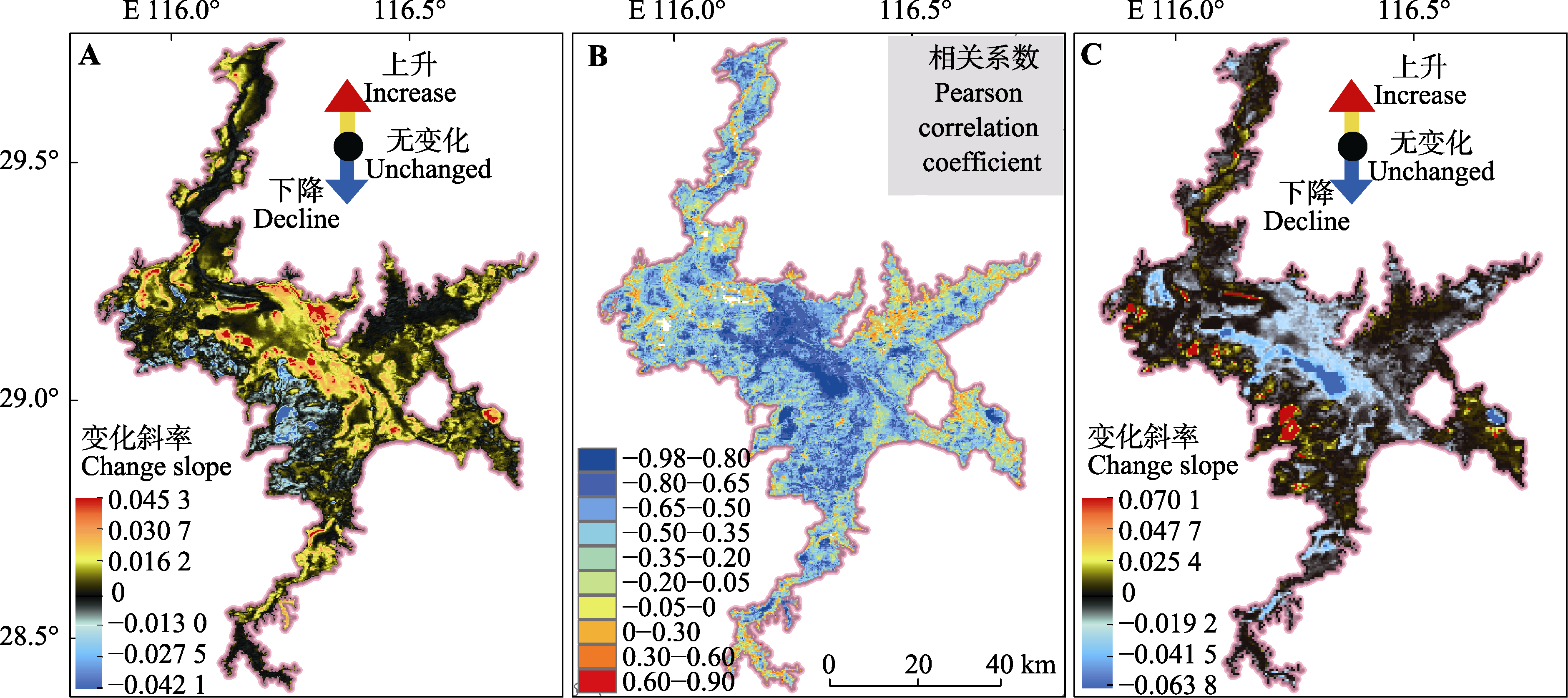
图12 鄱阳湖增强型植被指数(EVI)(A)与水淹频率(IF)(C)的变化趋势及相关性(B)。
Fig. 12 Correlation (B) and change trend of enhanced vegetation index (EVI) (A) and inundation frequency (IF) (C) of Poyang Lake.
| [1] |
Adam E, Mutanga O, Rugege D (2010). Multispectral and hyperspectral remote sensing for identification and mapping of wetland vegetation: a review. Wetlands Ecology and Management, 18, 281-296.
DOI URL |
| [2] |
Chen B, Chen LF, Huang B, Michishita R, Xu B (2018). Dynamic monitoring of the Poyang Lake wetland by integrating Landsat and MODIS observations. ISPRS Journal of Photogrammetry and Remote Sensing, 139, 75-87.
DOI URL |
| [3] | Chen YS (2020). The Effect of Flooding Duration and Underwater Light Intensity on Wetland Plant Functional Traits and Biomass in Poyang Lake. Master degree dissertation, Nanchang University, Nanchang. |
| [ 陈亚松 (2020). 水淹时长和水下光强对鄱阳湖湿地植物功能性状和生物量的影响. 硕士学位论文, 南昌大学, 南昌.] | |
| [4] |
Colmer TD, Voesenek LACJ (2009). Flooding tolerance: suites of plant traits in variable environments. Functional Plant Biology, 36, 665-681.
DOI PMID |
| [5] | Construction Office of Poyang Lake Water Control Project of Jiangxi Province (2013). Keep the lake water clear-Introduction of Poyang Lake Water Control Project. Jiangxi Hydraulic Science & Technology, 39(2), 83-91. |
| [ 江西省鄱阳湖水利枢纽建设办公室 (2013). 为了“一湖清水”--鄱阳湖水利枢纽工程介绍. 江西水利科技, 39(2), 83-91.] | |
| [6] | Cui BS (2006). Wetlands. Beijing Normal University Press, Beijing. 1-4. |
| [ 崔保山 (2006). 湿地学. 北京师范大学出版社, 北京. 1-4.] | |
| [7] |
Feng L, Hu CM, Chen XL, Cai XB, Tian LQ, Gan WX (2012). Assessment of inundation changes of Poyang Lake using MODIS observations between 2000 and 2010. Remote Sensing of Environment, 121, 80-92.
DOI URL |
| [8] | Gu J, Qin Y, Wang X, Ma JY, Guo ZH, Zou LJ, Shen XH (2018). Changes in inundation frequency in Poyang Lake and the response of wetland vegetation. Acta Ecologica Sinica, 38, 7718-7726. |
| [ 谷娟, 秦怡, 王鑫, 马静宇, 郭仲皓, 邹乐君, 沈晓华 (2018). 鄱阳湖水体淹没频率变化及其湿地植被的响应. 生态学报, 38, 7718-7726.] | |
| [9] | Han XX (2017). Spatio-temporal Dynamics of Poyang Lake Wetland Landscape Patterns Based Time Series Optical Remote Sensing Data in Poyang Lake. PhD dissertation, Wuhan University, Wuhan. |
| [ 韩杏杏 (2017). 基于长时序光学遥感数据的鄱阳湖湿地景观格局时空动态研究. 博士学位论文, 武汉大学, 武汉.] | |
| [10] |
Han XX, Chen XL, Feng L (2015). Four decades of winter wetland changes in Poyang Lake based on Landsat observations between 1973 and 2013. Remote Sensing of Environment, 156, 426-437.
DOI URL |
| [11] |
Han XX, Feng L, Hu CM, Chen XL (2018). Wetland changes of Chinaʼs largest freshwater lake and their linkage with the Three Gorges Dam. Remote Sensing of Environment, 204, 799-811.
DOI URL |
| [12] |
Hu YX, Huang JL, Du Y, Han PP, Wang JL, Huang W (2015). Monitoring wetland vegetation pattern response to water-level change resulting from the Three Gorges Project in the two largest freshwater lakes of China. Ecological Engineering, 74, 274-285.
DOI URL |
| [13] | Hu ZP, Fu J (2018). Quantitative study on hydrology relationship between the Yangtze River and Poyang Lake and its changes. Journal of Hydraulic Engineering, 49, 570-579. |
| [ 胡振鹏, 傅静 (2018). 长江与鄱阳湖水文关系及其演变的定量分析. 水利学报, 49, 570-579.] | |
| [14] | Hu ZP, Ge G, Liu CL (2015). Cause analysis and early warning for wetland vegetation degradation in Poyang Lake. Resources and Environment in the Yangtze Basin, 24, 381-386. |
| [ 胡振鹏, 葛刚, 刘成林 (2015). 鄱阳湖湿地植被退化原因分析及其预警. 长江流域资源与环境, 24, 381-386.] | |
| [15] | Huete A, Didan K, Miura T, Rodriguez EP, Gao X, Ferreira LG (2002). Overview of the radiometric and biophysical performance of the MODIS vegetation indices. Remote Sensing of Environment, 83, 195-213. |
| [16] |
Huete AR, Liu HQ, Batchily K, van Leeuwen W, (1997). A comparison of vegetation indices global set of TM images for EOS-MODIS. Remote Sensing of Environment, 59, 440-451.
DOI URL |
| [17] |
Kanai Y, Ueta M, Germogenov N, Nagendran M, Mita N, Higuchi H (2002). Migration routes and important resting areas of Siberian cranes (Grus leucogeranus) between northeastern Siberia and China as revealed by satellite tracking. Biological Conservation, 106, 339-346.
DOI URL |
| [18] |
Li YK, Zhong YF, Shao RQ, Yan C, Jin JF, Shan JH, Li FS, Ji WT, Bin L, Zhang XY, Cao KQ, Shen J (2020). Modified hydrological regime from the Three Gorges Dam increases the risk of food shortages for wintering waterbirds in Poyang Lake. Global Ecology and Conservation, 24, e01286. DOI: 10.1016/j.gecco.2020.e01286.
DOI URL |
| [19] |
Liu H, Zheng L, Jiang L, Liao M (2020). Forty-year water body changes in Poyang Lake and the ecological impacts based on Landsat and HJ-1 A/B observations. Journal of Hydrology, 589, 125161. DOI: 10.1016/j.jhydrol.2020.125161.
DOI URL |
| [20] | Liu Y, Guo HC, Zhou F, Wang Z, Huang K (2006). Role of water level fluctuation on aquatic vegetation in lakes. Acta Ecologica Sinica, 26, 3117-3126. |
| [ 刘永, 郭怀成, 周丰, 王真, 黄凯 (2006). 湖泊水位变动对水生植被的影响机理及其调控方法. 生态学报, 26, 3117-3126.] | |
| [21] |
Lucht W, Lewis P (2000). Theoretical noise sensitivity of BRDF and albedo retrieval from the EOS-MODIS and MISR sensors with respect to angular sampling. International Journal of Remote Sensing, 21, 81-98.
DOI URL |
| [22] |
Lucht W, Schaaf CB, Strahler AH (2000). An algorithm for the retrieval of albedo from space using semiempirical BRDF models. IEEE Transactions on Geoscience and Remote Sensing, 38, 977-998.
DOI URL |
| [23] |
Mu S, Li B, Yao J, Yang G, Wan R, Xu X (2020). Monitoring the spatio-temporal dynamics of the wetland vegetation in Poyang Lake by Landsat and MODIS observations. Science of the Total Environment, 725, 138096. DOI: 10.1016/j.scitotenv.2020.138096.
DOI URL |
| [24] |
Muala E, Mohamed YA, Duan Z, van der Zaag P, (2014). Estimation of reservoir discharges from Lake Nasser and roseires reservoir in the Nile Basin using satellite altimetry and imagery data. Remote Sensing, 6, 7522-7545.
DOI URL |
| [25] |
Richards JH, Troxler TG, Lee DW, Zimmerman MS (2011). Experimental determination of effects of water depth on Nymphaea odorata growth, morphology and biomass allocation. Aquatic Botany, 95, 9-16.
DOI URL |
| [26] |
Santoro M, Wegmüller U, Lamarche C, Bontemps S, Defourny P, Arino O (2015). Strengths and weaknesses of multi-year Envisat ASAR backscatter measurements to map permanent open water bodies at global scale. Remote Sensing of Environment, 171, 185-201.
DOI URL |
| [27] |
Schaaf CB, Gao F, Strahler AH, Lucht W, Li XW, Tsang T, Strugnell NC, Zhang XY, Jin YF, Muller JP, Lewis P, Barnsley M, Hobson P, Disney M, Roberts G, et al. (2002). First operational BRDF, albedo nadir reflectance products from MODIS. Remote Sensing of Environment, 83, 135-148.
DOI URL |
| [28] | Shi MF, Zeng B, Shen JH, Lei ST, Zhu Z, Liu JH (2010). A review of the correlation of flooding adaptability and carbohydrates in plants. Chinese Journal of Plant Ecology, 34, 855-866. |
|
[ 施美芬, 曾波, 申建红, 类淑桐, 朱智, 刘建辉 (2010). 植物水淹适应与碳水化合物的相关性. 植物生态学报, 34, 855-866.]
DOI |
|
| [29] | Sun FD, Ma RH (2020). Hydrologic changes of Poyang Lake based on radar altimeter and optical sensor. Acta Geographica Sinica, 75, 544-557. |
|
[ 孙芳蒂, 马荣华 (2020). 鄱阳湖水文特征动态变化遥感监测. 地理学报, 75, 544-557.]
DOI |
|
| [30] | Sun FD, Zhao YY, Gong P, Ma RH, Dai YJ (2014). Monitoring dynamic changes of global land cover types: fluctuations of major lakes in China every 8 days during 2000-2010. Chinese Science Bulletin, 59, 171-189. |
| [31] |
Sun YY, Huang SF, Li JR, Li XT, Ma JW, Li SY, Wang H (2015). Dynamic monitoring of Poyang Lake water body area using MODIS images between 2000 and 2014. Proceedings of the SPIE, 9808, 98081S8. DOI: 10.1117/12. 2209293.
DOI |
| [32] |
Tan ZQ, Zhang Q, Li MF, Li YL, Xu XL, Jiang JH (2016). A study of the relationship between wetland vegetation communities and water regimes using a combined remote sensing and hydraulic modeling approach. Hydrology Research, 47, 278-292.
DOI URL |
| [33] |
Townshend JRG, Justice CO (2002). Towards operational monitoring of terrestrial systems by moderate-resolution remote sensing. Remote Sensing of Environment, 83, 351-359.
DOI URL |
| [34] |
Tucker CJ (1979). Red and photographic infrared linear combinations for monitoring vegetation. Remote Sensing of Environment, 8, 127-150.
DOI URL |
| [35] | Wan RR, Dai X, Shankman D (2019). Vegetation response to hydrological changes in Poyang Lake, China. Wetlands, 39, 99-112. |
| [36] |
Wang L, Dronova I, Gong P, Yang WB, Li YR, Liu Q (2012). A new time series vegetation-water index of phenological- hydrological trait across species and functional types for Poyang Lake wetland ecosystem. Remote Sensing of Environment, 125, 49-63.
DOI URL |
| [37] |
Wang XX, Xiao XM, Zou ZH, Hou LY, Qin YW, Dong JW, Doughty RB, Chen BQ, Zhang X, Chen Y, Ma J, Zhao B, Li B (2020). Mapping coastal wetlands of China using time series Landsat images in 2018 and Google Earth Engine. ISPRS Journal of Photogrammetry and Remote Sensing, 163, 312-326.
DOI URL |
| [38] |
Wang ZS, Schaaf CB, Sun QS, Kim J, Erb AM, Gao F, Román MO, Yang Y, Petroy S, Taylor JR, Masek JG, Morisette JT, Zhang XY, Papuga SA (2017). Monitoring land surface albedo and vegetation dynamics using high spatial and temporal resolution synthetic time series from Landsat and the MODIS BRDF/NBAR/albedo product. International Journal of Applied Earth Observation and Geoinformation, 59, 104-117.
DOI URL |
| [39] |
Wang ZS, Schaaf CB, Sun QS, Shuai YM, Román MO (2018). Capturing rapid land surface dynamics with Collection V006 MODIS BRDF/NBAR/Albedo (MCD43) products. Remote Sensing of Environment, 207, 50-64.
DOI URL |
| [40] |
Wu GP, Liu YB (2015). Capturing variations in inundation with satellite remote sensing in a morphologically complex, large lake. Journal of Hydrology, 523, 14-23.
DOI URL |
| [41] |
Wu GP, Liu YB (2016). Mapping dynamics of inundation patterns of two largest river-connected lakes in China: a comparative study. Remote Sensing, 8, 560. DOI: 10.3390/rs8070560.
DOI URL |
| [42] |
Xu HQ (2006). Modification of normalised difference water index (NDWI) to enhance open water features in remotely sensed imagery. International Journal of Remote Sensing, 27, 3025-3033.
DOI URL |
| [43] |
Xu KH, Milliman JD (2009). Seasonal variations of sediment discharge from the Yangtze River before and after impoundment of the Three Gorges Dam. Geomorphology, 104, 276-283.
DOI URL |
| [44] |
Ye XC, Meng YK, Xu LG, Xu CY (2019). Net primary productivity dynamics and associated hydrological driving factors in the floodplain wetland of Chinaʼs largest freshwater lake. Science of the Total Environment, 659, 302-313.
DOI URL |
| [45] |
Zhang Q, Li L, Wang YG, Werner AD, Xin P, Jiang T, Barry DA (2012). Has the Three-Gorges Dam made the Poyang Lake wetlands wetter and drier? Geophysical Research Letters, 39, L20402. DOI: 10.1029/2012GL053431.
DOI |
| [46] |
Zhou Y, Dong JW, Xiao XM, Liu RG, Zou ZH, Zhao GS, Ge QS (2019). Continuous monitoring of lake dynamics on the Mongolian Plateau using all available Landsat imagery and Google Earth Engine. Science of the Total Environment, 689, 366-380.
DOI URL |
| [47] |
Zhou Y, Dong JW, Xiao XM, Xiao T, Yang ZQ, Zhao GS, Zou ZH, Qin YW (2017). Open surface water mapping algorithms: a comparison of water-related spectral indices and sensors. Water, 9, 256. DOI: 10.3390/w9040256.
DOI URL |
| [48] |
Zou Z, Dong J, Menarguez MA, Xiao X, Qin Y, Doughty RB, Hooker KV, Hambright KD (2017). Continued decrease of open surface water body area in Oklahoma during 1984-2015. Science of the Total Environment, 595, 451-460.
DOI URL |
| [49] | Zou Z, Xiao X, Dong J, Qin Y, Doughty RB, Menarguez MA, Zhang G, Wang J (2018). Divergent trends of open-surface water body area in the contiguous United States from 1984 to 2016. Proceedings of the National Academy of Sciences of the United States of America, 115, 3810-3815. |
| [1] | 李伯新, 姜超, 孙建新. CMIP6模式对中国西南部地区植被碳利用率模拟能力综合评估[J]. 植物生态学报, 2023, 47(9): 1211-1224. |
| [2] | 周红艳, 吴琴, 陈明月, 匡伟, 常玲玲, 胡启武. 鄱阳湖沙山单叶蔓荆不同器官碳、氮、磷化学计量特征[J]. 植物生态学报, 2017, 41(4): 461-470. |
| [3] | 方全, 刘以珍, 葛刚. 鄱阳湖流域含珍稀针叶树种的群落特征[J]. 植物生态学报, 2016, 40(9): 952-957. |
| [4] | 胡伟芳, 章文龙, 张林海, 陈晓艳, 林伟, 曾从盛, 仝川. 中国主要湿地植被氮和磷生态化学计量学特征[J]. 植物生态学报, 2014, 38(10): 1041-1052. |
| [5] | 李征, 韩琳, 刘玉虹, 安树青, 冷欣. 滨海盐地碱蓬不同生长阶段叶片C、N、P化学计量特征[J]. 植物生态学报, 2012, 36(10): 1054-1061. |
| [6] | 宋春桥, 游松财, 柯灵红, 刘高焕, 钟新科. 藏北高原植被物候时空动态变化的遥感监测研究[J]. 植物生态学报, 2011, 35(8): 853-863. |
| [7] | 徐洋, 刘文治, 刘贵华. 生态位限制和物种库限制对湖滨湿地植物群落分布格局的影响[J]. 植物生态学报, 2009, 33(3): 546-554. |
| [8] | 王相磊, 周进, 李伟, 刘贵华, 张学江. 洪湖湿地退耕初期种子库的季节动态[J]. 植物生态学报, 2003, 27(3): 352-359. |
| [9] | 简永兴, 李仁东, 王建波, 陈家宽. 鄱阳湖滩地水生植物多样性调查及滩地植被的遥感研究[J]. 植物生态学报, 2001, 25(5): 581-587. |
| [10] | 王海洋, 陈家宽. 湿地植被组成种的生态位分离[J]. 植物生态学报, 1999, 23(199901): 187-193. |
| 阅读次数 | ||||||
|
全文 |
|
|||||
|
摘要 |
|
|||||
Copyright © 2026 版权所有 《植物生态学报》编辑部
地址: 北京香山南辛村20号, 邮编: 100093
Tel.: 010-62836134, 62836138; Fax: 010-82599431; E-mail: apes@ibcas.ac.cn, cjpe@ibcas.ac.cn
备案号: 京ICP备16067583号-19
![]()