
植物生态学报 ›› 2023, Vol. 47 ›› Issue (9): 1211-1224.DOI: 10.17521/cjpe.2022.0116
所属专题: 生态遥感及应用
李伯新, 姜超*( ), 孙建新
收稿日期:2022-04-02
接受日期:2022-12-03
出版日期:2023-09-20
发布日期:2023-09-28
通讯作者:
* 姜超(基金资助:
LI Bo-Xin, JIANG Chao*(), SUN Osbert Jianxin
Received:2022-04-02
Accepted:2022-12-03
Online:2023-09-20
Published:2023-09-28
Contact:
* JIANG Chao(Supported by:摘要:
中国西南部地区地形复杂, 生态系统和植被类型丰富多样, 是重要的生态资源区。受气候变化和人类活动影响, 其生态屏障作用不断被减弱, 准确评估该地区的植被碳利用率(CUE)对揭示碳平衡机理和预测陆地碳收支具有重要意义。该研究利用2001-2014年MODIS遥感观测数据和参加第六次国际耦合模式比较计划(CMIP6)的15个模式模拟数据, 分别从年和季节尺度综合分析了新一代模式对中国西南部地区植被CUE的模拟能力, 并基于综合评级指标(MR)对模式的模拟能力进行排名, 以寻求模拟能力较好的模式, 旨在有效降低未来预估结果的不确定性。结果表明: (1)大多数模式对年尺度区域平均植被CUE的模拟存在低估情况, 且对植被CUE空间变化趋势的模拟能力相对较差, 但部分模式可以较好地模拟出多年平均植被CUE空间分布, 其中位于前1/3的较优模式依次为BCC-CSM2-MR、CMCC-ESM2、TaiESM、EC-Earth3-Veg、CAS-ESM2-0; (2)四个季节中, 各模式对夏季多年平均植被CUE空间分布模拟能力最优, 其中位于前1/3的较优模式依次为BCC-CSM2-MR、EC-Earth3-Veg、TaiESM、CMCC-ESM2、CAS-ESM2-0, 各模式对冬季的模拟能力仅次于夏季, 而春季和秋季则相对较差; (3)相较于单一模式而言, 较优模式的集合在一定程度上可以削弱单一模式带来的不确定性, 且在各时间尺度都表现出了较强的模拟能力, 尤其可以合理再现四川盆地等局部地区植被CUE空间分布特点, 但是对青藏高原以及横断山区等地形复杂区域植被CUE空间分布的模拟能力仍存在不足。总体来说, 在使用CMIP6模式进行区域植被CUE模拟前, 从多角度展开多模式的综合评估以挑选出模拟性能较好的模式是十分必要的。
李伯新, 姜超, 孙建新. CMIP6模式对中国西南部地区植被碳利用率模拟能力综合评估. 植物生态学报, 2023, 47(9): 1211-1224. DOI: 10.17521/cjpe.2022.0116
LI Bo-Xin, JIANG Chao, SUN Osbert Jianxin. Comprehensive assessment of vegetation carbon use efficiency in southwestern China simulated by CMIP6 models. Chinese Journal of Plant Ecology, 2023, 47(9): 1211-1224. DOI: 10.17521/cjpe.2022.0116
| 模式名称 Model name | 所属机构 Institution | 网格分辨率 Spatial resolution | 陆面模式 Land surface model |
|---|---|---|---|
| ACCESS-ESM1-5 | Commonwealth Scientific and Industrial Research Organisation, Australia | 192 × 145 | CABLE2.4 |
| BCC-CSM2-MR | 北京市气候中心 Beijing Climate Center, China | 320 × 160 | BCC_AVIM2 |
| CanESM5 | Canadian Centre for Climate Modelling and Analysis, Canada | 128 × 64 | CLASS3.6/CTEM1.2 |
| CAS-ESM2-0 | 中国科学院 Chinese Academy of Sciences, China | 256 × 128 | CoLM |
| CESM2-WACCM | National Center for Atmospheric Research, Climate and Global Dynamics Laboratory, USA | 288 × 192 | CLM5 |
| CMCC-CM2-SR5 | Fondazione Centro Euro-Mediterraneo sui Cambiamenti Climatici, Italy | 288 × 192 | CLM4.5 (BGC mode) |
| CMCC-ESM2 | Fondazione Centro Euro-Mediterraneo sui Cambiamenti Climatici, Italy | 288 × 192 | CLM4.5 (BGC mode) |
| EC-Earth3-Veg | EC-Earth consortium, European Union | 512 × 256 | HTESSEL/LPJ-GUESS v4 |
| EC-Earth3-Veg-LR | EC-Earth consortium, European Union | 320 × 160 | HTESSEL/LPJ-GUESS v4 |
| INM-CM4-8 | Institute for Numerical Mathematics, Russian Academy of Sciences, Russia | 180 × 120 | INM-LND1 |
| INM-CM5-0 | Institute for Numerical Mathematics, Russian Academy of Sciences, Russia | 180 × 120 | INM-LND1 |
| IPSL-CM6A-LR | Institut Pierre Simon Laplace, France | 144 × 143 | ORCHIDEE (v2.0) |
| MPI-ESM1-2-HR | Max Planck Institute for Meteorology, Germany | 384 × 192 | JSBACH3.20 |
| MPI-ESM1-2-LR | Max Planck Institute for Meteorology, Germany | 192 × 96 | JSBACH3.20 |
| TaiESM | “中研院”环境变迁研究中心 Research Center for Environmental Changes, Academia Sinica, Taiwan, China | 288 × 192 | CLM4.0 |
表1 本研究使用的15个CMIP6模式基本信息
Table 1 General information of the 15 CMIP6 models used in this study
| 模式名称 Model name | 所属机构 Institution | 网格分辨率 Spatial resolution | 陆面模式 Land surface model |
|---|---|---|---|
| ACCESS-ESM1-5 | Commonwealth Scientific and Industrial Research Organisation, Australia | 192 × 145 | CABLE2.4 |
| BCC-CSM2-MR | 北京市气候中心 Beijing Climate Center, China | 320 × 160 | BCC_AVIM2 |
| CanESM5 | Canadian Centre for Climate Modelling and Analysis, Canada | 128 × 64 | CLASS3.6/CTEM1.2 |
| CAS-ESM2-0 | 中国科学院 Chinese Academy of Sciences, China | 256 × 128 | CoLM |
| CESM2-WACCM | National Center for Atmospheric Research, Climate and Global Dynamics Laboratory, USA | 288 × 192 | CLM5 |
| CMCC-CM2-SR5 | Fondazione Centro Euro-Mediterraneo sui Cambiamenti Climatici, Italy | 288 × 192 | CLM4.5 (BGC mode) |
| CMCC-ESM2 | Fondazione Centro Euro-Mediterraneo sui Cambiamenti Climatici, Italy | 288 × 192 | CLM4.5 (BGC mode) |
| EC-Earth3-Veg | EC-Earth consortium, European Union | 512 × 256 | HTESSEL/LPJ-GUESS v4 |
| EC-Earth3-Veg-LR | EC-Earth consortium, European Union | 320 × 160 | HTESSEL/LPJ-GUESS v4 |
| INM-CM4-8 | Institute for Numerical Mathematics, Russian Academy of Sciences, Russia | 180 × 120 | INM-LND1 |
| INM-CM5-0 | Institute for Numerical Mathematics, Russian Academy of Sciences, Russia | 180 × 120 | INM-LND1 |
| IPSL-CM6A-LR | Institut Pierre Simon Laplace, France | 144 × 143 | ORCHIDEE (v2.0) |
| MPI-ESM1-2-HR | Max Planck Institute for Meteorology, Germany | 384 × 192 | JSBACH3.20 |
| MPI-ESM1-2-LR | Max Planck Institute for Meteorology, Germany | 192 × 96 | JSBACH3.20 |
| TaiESM | “中研院”环境变迁研究中心 Research Center for Environmental Changes, Academia Sinica, Taiwan, China | 288 × 192 | CLM4.0 |
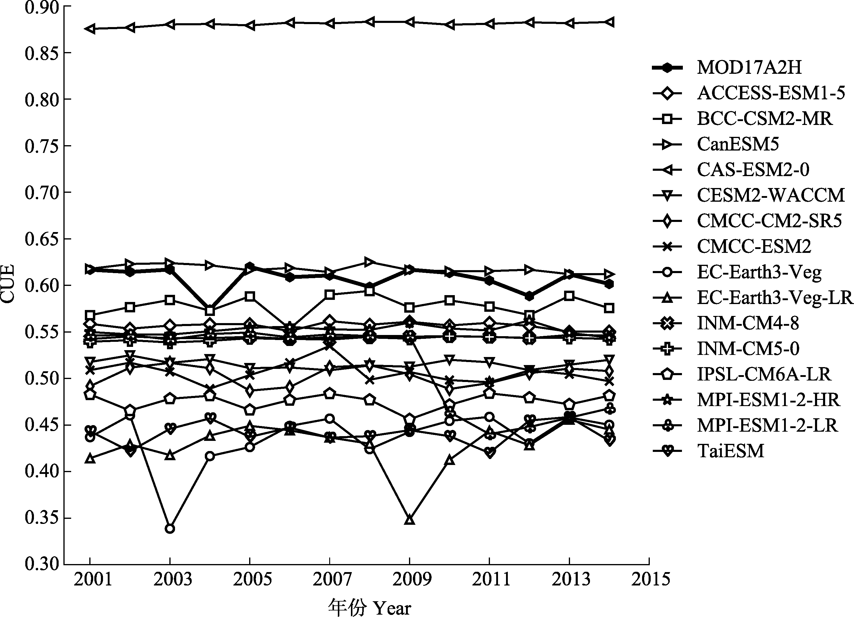
图1 MODIS观测(MOD17A2H)和CMIP6模式模拟的2001-2014年中国西南部地区区域平均植被碳利用率(CUE)的多年变化。各模式信息见表1。
Fig. 1 Inter-annual variations in regional mean vegetation carbon use efficiency (CUE) from MODIS observations (MOD17A2H) and simulations by CMIP6 models in southwestern China from 2001 to 2014. See Table 1 for general information on models.
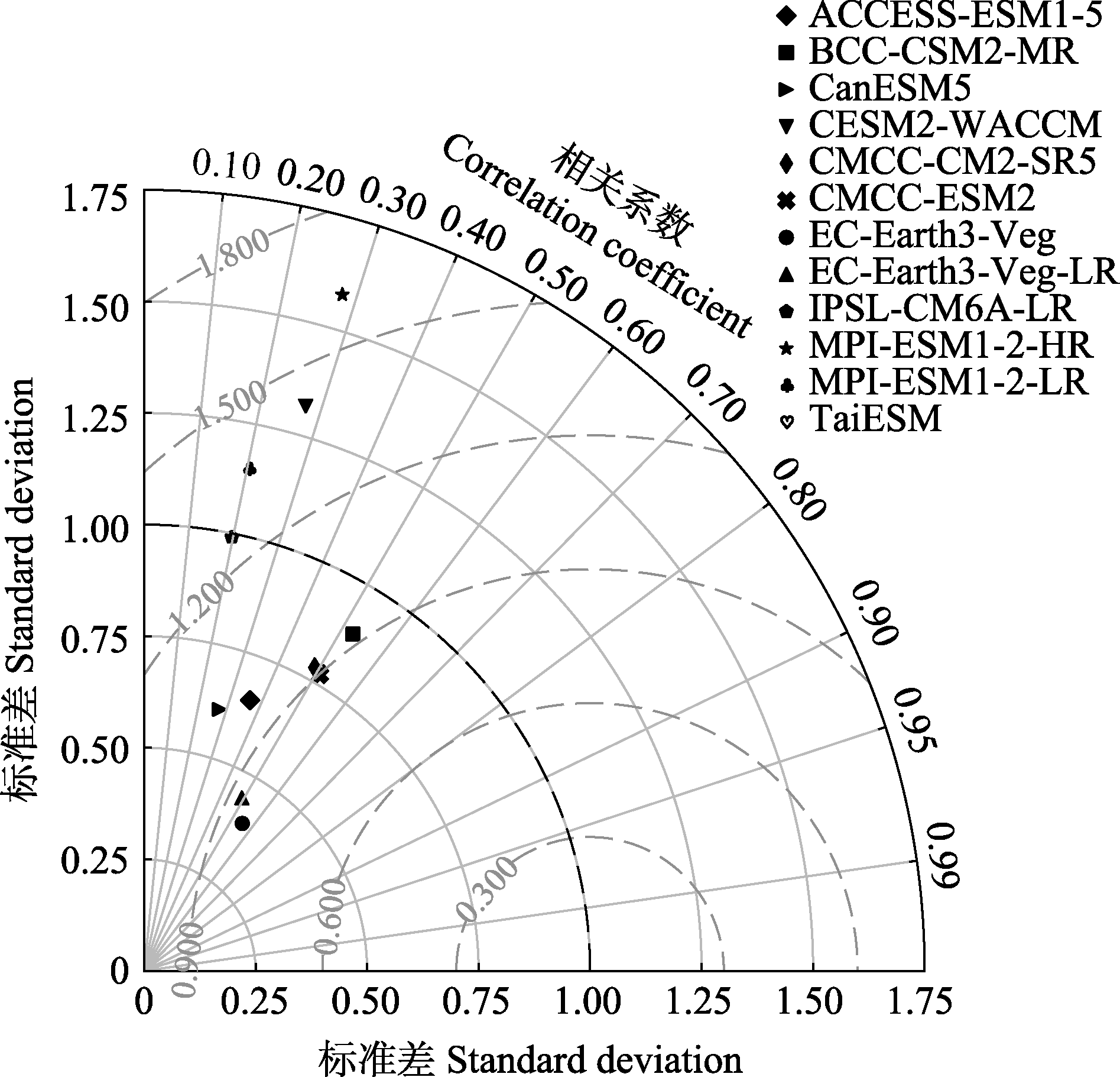
图2 CMIP6模式模拟的2001-2014年中国西南部地区多年平均植被碳利用率(CUE)空间分布相对于MODIS观测(MOD17A2H)场的泰勒图。各模式信息见表1。图中辐射线代表相关系数, 虚线代表均方根误差。
Fig. 2 Taylor diagram for the spatial distribution of multi-year average vegetation carbon use efficiency (CUE) relative to the MODIS observation (MOD17A2H) field in southwestern China simulated by the CMIP6 models from 2001 to 2014. See Table 1 for general information on models. The radial line represents the correlation coefficient and the dashed line represents the root mean square error.
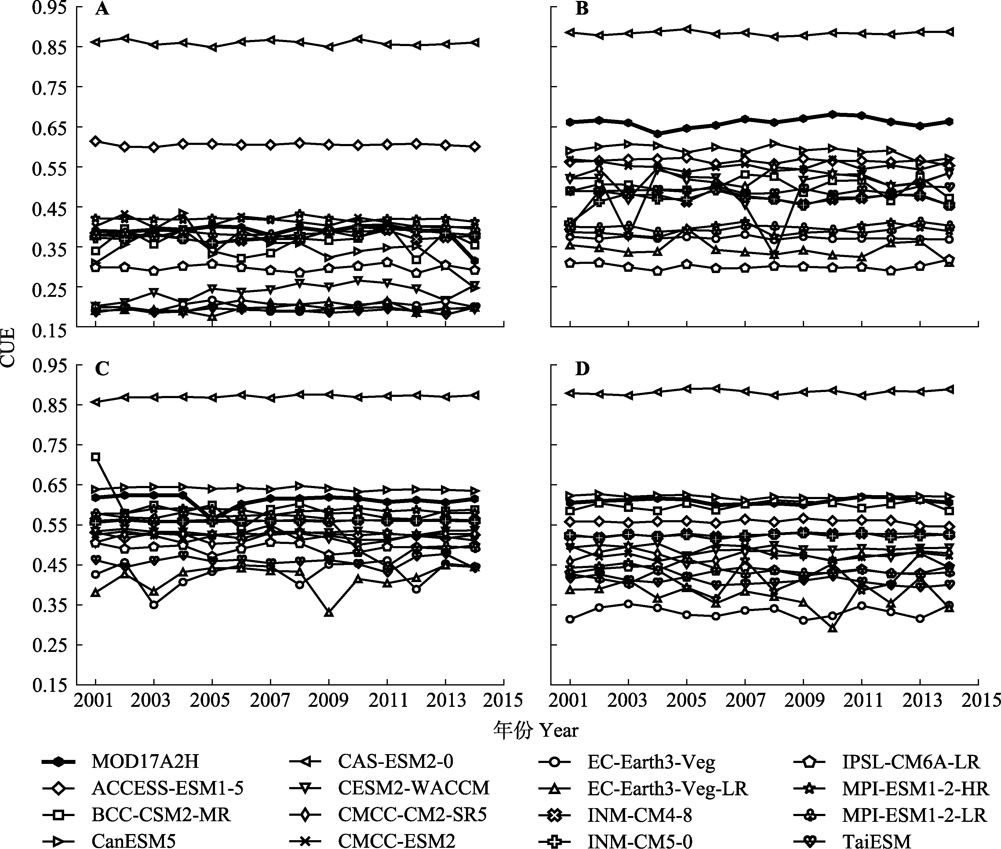
图3 MODIS观测(MOD17A2H)和CMIP6模式模拟的2001-2014年中国西南部地区季节尺度区域平均植被碳利用率(CUE)的多年变化。A, 冬季。B, 春季。C, 夏季。D, 秋季。各模式信息见表1。
Fig. 3 Inter-annual variations in seasonal-scale regional mean vegetation carbon use efficiency (CUE) from MODIS observations (MOD17A2H) and simulations by CMIP6 models in southwestern China from 2001 to 2014. A, Winter. B, Spring. C, Summer. D, Fall. See Table 1 for general information on models.
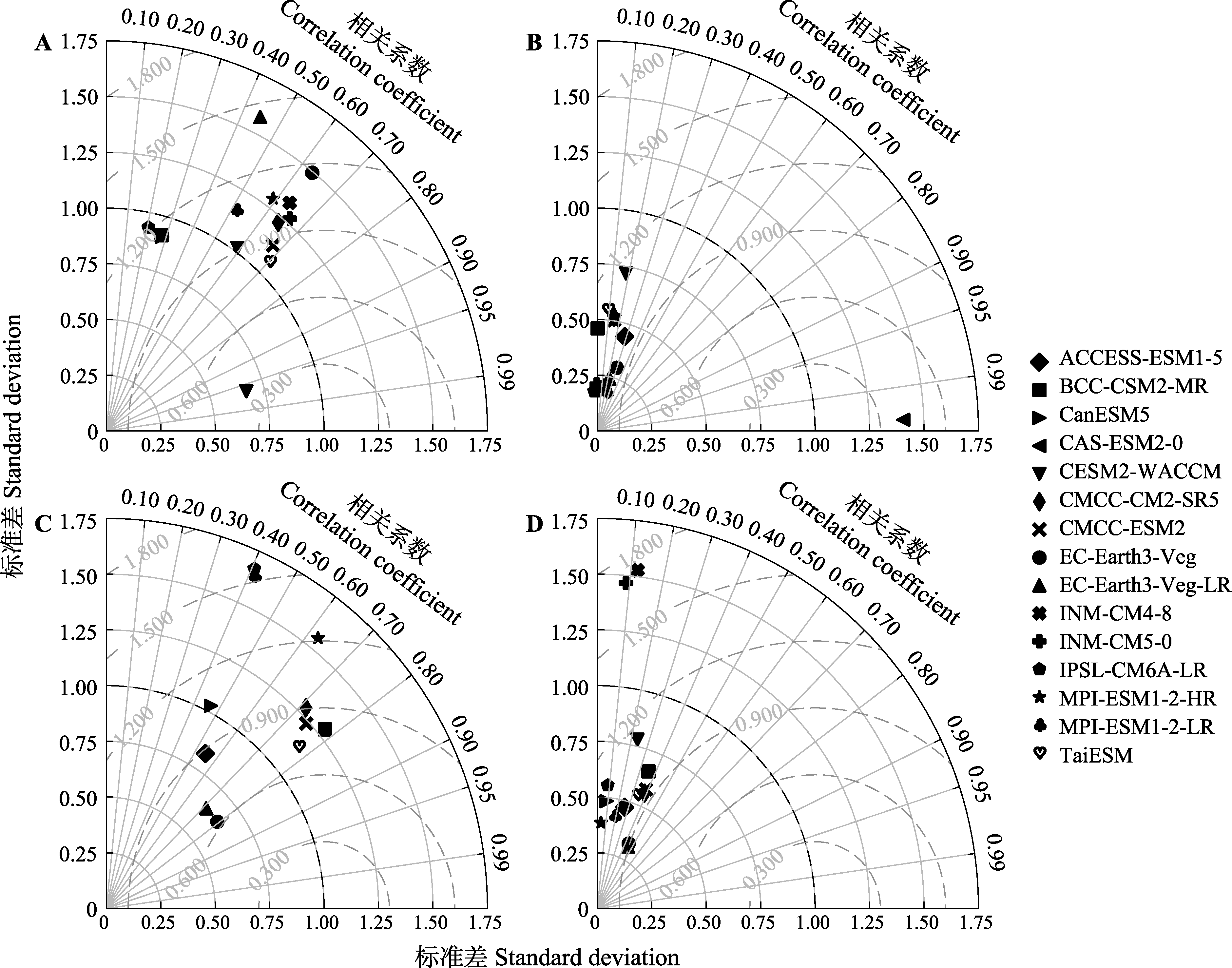
图4 CMIP6模式模拟的2001-2014年中国西南部地区季节尺度多年平均植被碳利用率(CUE)空间分布相对于MODIS (MOD17A2H)观测场的泰勒图。A, 冬季。B, 春季。C, 夏季。D, 秋季。各模式信息见表1。图中辐射线代表相关系数, 虚线代表均方根误差。
Fig. 4 Seasonal-scale Taylor diagram for the spatial distribution of multi-year average vegetation carbon use efficiency (CUE) by the CMIP6 models from 2001 to 2014 relative to the MODIS observation (MOD17A2H) field in southwestern China simulated. A, Winter. B, Spring. C, Summer. D, Fall. See Table 1 for general information on models. The radial line represents the correlation coefficient and the dashed line represents the root mean square error.
| 模式名称 Model name | ANN | DJF | MAM | JJA | SON |
|---|---|---|---|---|---|
| ACCESS-ESM1-5 | 8 | 15 | 1 | 8 | 9 |
| BCC-CSM2-MR | 1 | 11 | 10 | 1 | 3 |
| CanESM5 | 11 | 10 | 14 | 8 | 14 |
| CAS-ESM2-0 | 5 | 14 | 4 | 5 | 4 |
| CESM2-WACCM | 11 | 5 | 3 | 15 | 7 |
| CMCC-CM2-SR5 | 6 | 4 | 6 | 6 | 1 |
| CMCC-ESM2 | 2 | 2 | 5 | 4 | 2 |
| EC-Earth3-Veg | 4 | 7 | 1 | 1 | 6 |
| EC-Earth3-Veg-LR | 7 | 13 | 6 | 7 | 5 |
| INM-CM4-8 | 14 | 6 | 12 | 14 | 10 |
| INM-CM5-0 | 15 | 3 | 13 | 13 | 10 |
| IPSL-CM6A-LR | 9 | 11 | 15 | 12 | 13 |
| MPI-ESM1-2-HR | 11 | 7 | 11 | 10 | 15 |
| MPI-ESM1-2-LR | 9 | 9 | 8 | 11 | 10 |
| TaiESM | 3 | 1 | 9 | 1 | 8 |
| MME-S | 1 | 1 | 1 | 1 | 1 |
表2 CMIP6模式对2001-2014年中国西南部地区年和季节尺度多年平均植被碳利用率(CUE)空间分布模拟能力的综合排名
Table 2 Integrative ranking of the CMIP6 models capability to simulate the annual and seasonal scale spatial distributions in multi-year average vegetation carbon use efficiency (CUE) in southwestern China from 2001 to 2014
| 模式名称 Model name | ANN | DJF | MAM | JJA | SON |
|---|---|---|---|---|---|
| ACCESS-ESM1-5 | 8 | 15 | 1 | 8 | 9 |
| BCC-CSM2-MR | 1 | 11 | 10 | 1 | 3 |
| CanESM5 | 11 | 10 | 14 | 8 | 14 |
| CAS-ESM2-0 | 5 | 14 | 4 | 5 | 4 |
| CESM2-WACCM | 11 | 5 | 3 | 15 | 7 |
| CMCC-CM2-SR5 | 6 | 4 | 6 | 6 | 1 |
| CMCC-ESM2 | 2 | 2 | 5 | 4 | 2 |
| EC-Earth3-Veg | 4 | 7 | 1 | 1 | 6 |
| EC-Earth3-Veg-LR | 7 | 13 | 6 | 7 | 5 |
| INM-CM4-8 | 14 | 6 | 12 | 14 | 10 |
| INM-CM5-0 | 15 | 3 | 13 | 13 | 10 |
| IPSL-CM6A-LR | 9 | 11 | 15 | 12 | 13 |
| MPI-ESM1-2-HR | 11 | 7 | 11 | 10 | 15 |
| MPI-ESM1-2-LR | 9 | 9 | 8 | 11 | 10 |
| TaiESM | 3 | 1 | 9 | 1 | 8 |
| MME-S | 1 | 1 | 1 | 1 | 1 |
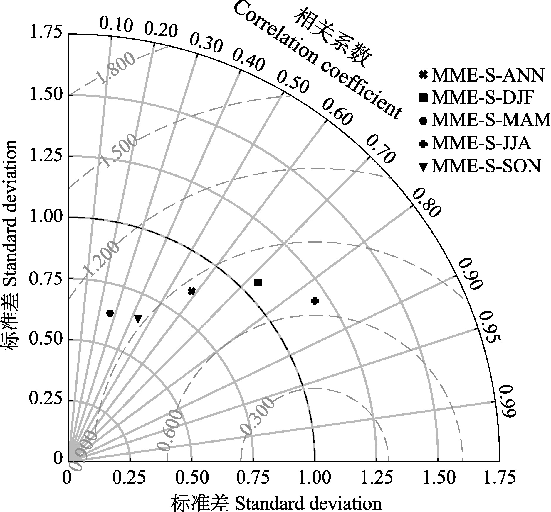
图5 较优模式集合模拟的2001-2014年中国西南部地区年和季节尺度多年平均植被碳利用率(CUE)空间分布相对于MODIS (MOD17A2H)观测场的泰勒图。MME-S-ANN、MME-S-DJF、MME-S-MAM、MME-S-JJA、MME-S-SON分别为年、冬季、春季、夏季、秋季尺度多年平均较优模式的集合。图中辐射线代表相关系数, 虚线代表均方根误差。
Fig. 5 Annual and seasonal scale Taylor diagram for the spatial distribution of multi-year average vegetation carbon use efficiency (CUE) simulated by the MME-S from 2001 to 2014 relative to the MODIS observation (MOD17A2H) in southwestern China. MME-S-ANN, MME-S-DJF, MME-S-MAM, MME-S-JJA and MME-S-S-SON are collections of annual, winter, spring, summer and autumn multi-year mean-scale better models, respectively. The radial line represents the correlation coefficient and the dashed line represents the root mean square error.
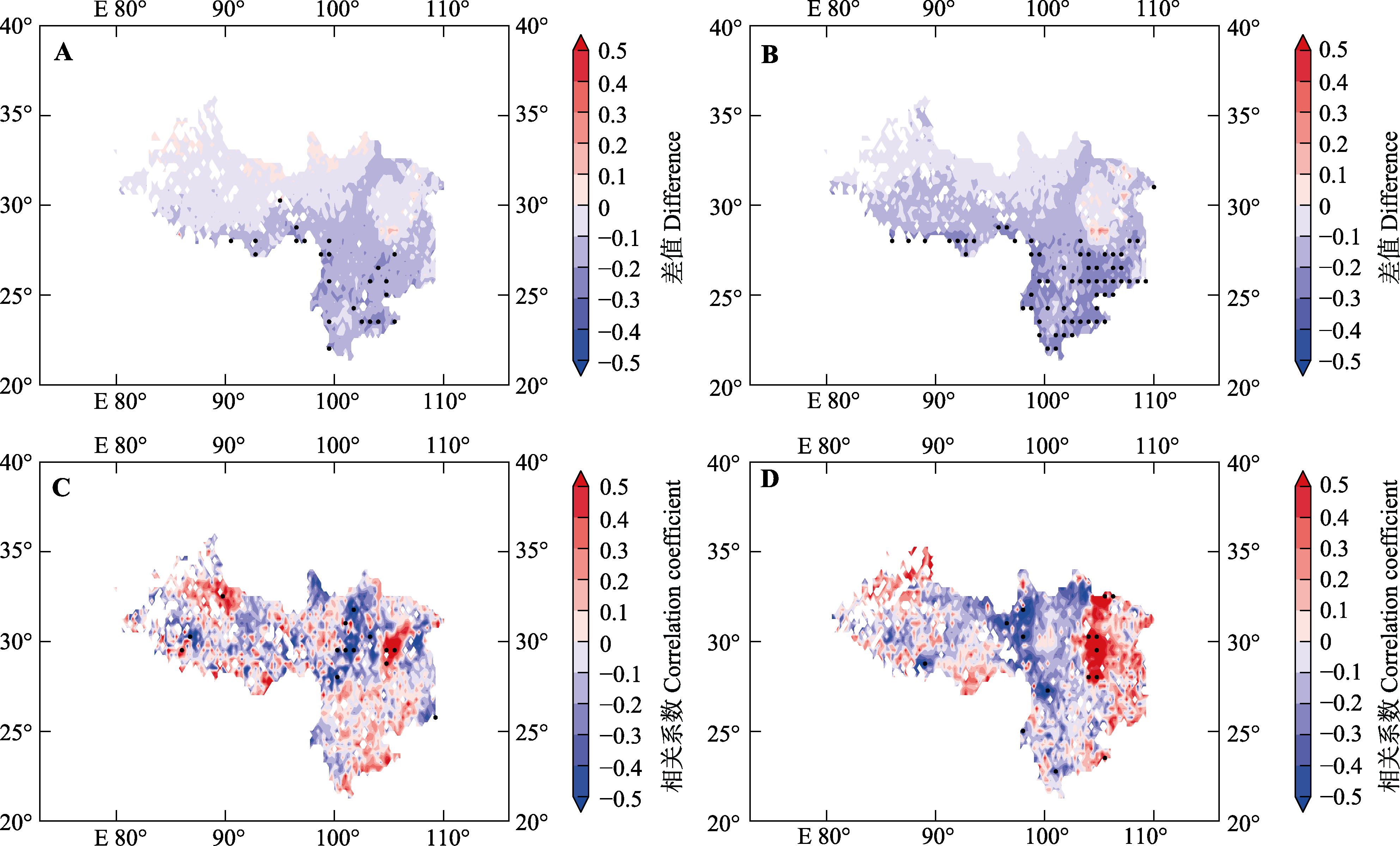
图6 较优模式集合模拟的2001-2014年中国西南部地区年平均及夏季多年平均植被碳利用率(CUE)与MODIS观测的差值空间分布(A、B)及相关关系(C、D)空间分布。A、C为年尺度; B、D为夏季。对于差值空间分布(A、B)打点区域为差值绝对值>0.2, 对于相关关系空间分布(C、D)打点区域为通过95%置信度检验。
Fig. 6 Spatial patterns in the differences (A、B) and correlations (C、D) between multi-year average and summer average vegetation carbon use efficiency (CUE) and MODIS observations in southwestern China from 2001 to 2014. A, C are annual average; B, D are summer average. For the spatial patterns of differences (A, B), the punctured region is the absolute value of differences > 0.2, and for the spatial patterns of correlations (C, D), the punctured region passes the 95% confidence test.
| [1] |
Anav A, Friedlingstein P, Kidston M, Bopp L, Ciais P, Cox P, Jones C, Jung M, Myneni R, Zhu Z (2013). Evaluating the land and ocean components of the global carbon cycle in the CMIP5 earth system models. Journal of Climate, 26, 6801-6843.
DOI URL |
| [2] |
Bradford MA, Crowther TW (2013). Carbon use efficiency and storage in terrestrial ecosystems. New Phytologist, 199, 7-9.
DOI PMID |
| [3] |
Chambers JQ, Tribuzy ES, Toledo LC, Crispim BF, Higuchi N, dos Santos J, Araújo AC, Kruijt B, Nobre AD, Trumbore SE (2004). Respiration from a tropical forest ecosystem: partitioning of sources and low carbon use efficiency. Ecological Applications, 14, 72-88.
DOI URL |
| [4] | Chen HP (2013). Projected change in extreme rainfall events in China by the end of the 21st century using CMIP5 models. Chinese Science Bulletin, 58, 743-752. |
| [陈活泼 (2013). CMIP5模式对21世纪末中国极端降水事件变化的预估. 科学通报, 58, 743-752.] | |
| [5] | Chen S, Ye T, Liu WH, Wang AH (2021). Evaluation and bias correction of the historical and future near-surface climate forcing in NEX-GDDP and CMIP5 over the Qinghai- Xizang Plateau. Plateau Meteorology, 40, 257-271. |
|
[陈说, 叶涛, 刘苇航, 王爱慧 (2021). NEX-GDDP和CMIP5对青藏高原地区近地面气象场历史和未来模拟的评估与偏差校正. 高原气象, 40, 257-271.]
DOI |
|
| [6] | Chen Z (2019). Spatiotemporal variation of productivity and carbon use efficiency of forests in Northeast China from 2000 to 2015. Chinese Journal of Applied Ecology, 30, 1625-1632. |
|
[陈智 (2019). 2000-2015 年中国东北森林生产力和碳素利用率的时空变异. 应用生态学报, 30, 1625-1632.]
DOI |
|
| [7] | Chuai XW, Guo XM, Zhang M, Yuan Y, Li JS, Zhao RQ, Yang WJ, Li JB (2020). Vegetation and climate zones based carbon use efficiency variation and the main determinants analysis in China. Ecological Indicators, 111, 105967. DOI: 10.1016/j.ecolind.2019.105967. |
| [8] |
Cui E, Huang K, Arain MA, Fisher JB, Huntzinger DN, Ito A, Luo Y, Jain AK, Mao J, Michalak AM, Niu S, Parazoo NC, Peng C, Peng S, Poulter B, et al. (2019). Vegetation functional properties determine uncertainty of simulated ecosystem productivity: a traceability analysis in the east Asian monsoon region. Global Biogeochemical Cycles, 33, 668-689.
DOI URL |
| [9] |
Curtis PS, Vogel CS, Gough CM, Schmid HP, Su HB, Bovard BD (2005). Respiratory carbon losses and the carbon-use efficiency of a northern hardwood forest, 1999-2003. New Phytologist, 167, 437-455.
PMID |
| [10] | Di YP, Zeng H, Zhang YJ, Chen N, Cong N (2021). Research advances in carbon use efficiency at multiple scales. Chinese Journal of Ecology, 40, 1849-1860. |
| [底阳平, 曾辉, 张扬建, 陈宁, 丛楠 (2021). 多尺度碳利用效率研究进展. 生态学杂志, 40, 1849-1860.] | |
| [11] |
Döscher R, Acosta M, Alessandri A, Anthoni P, Arsouze T, Bergman T, Bernardello R, Boussetta S, Caron LP, Carver G, Castrillo M, Catalano F, Cvijanovic I, Davini P, Dekker E, et al. (2022). The EC-Earth3 Earth system model for the Coupled Model Intercomparison Project 6. Geoscientific Model Development, 15, 2973-3020.
DOI URL |
| [12] | Doughty CE, Goldsmith GR, Raab N, Girardin CAJ, Farfan-Amezquita F, Huaraca-Huasco W, Silva-Espejo JE, Araujo-Murakami A, da Costa ACL, Rocha W, Galbraith D, Meir P, Metcalfe DB, Malhi Y (2018). What controls variation in carbon use efficiency among Amazonian tropical forests? Biotropica, 50, 16-25. |
| [13] | Du LT, Gong F, Zeng YJ, Ma LL, Qiao CL, Wu HY (2021). Carbon use efficiency of terrestrial ecosystems in desert/grassland biome transition zone: a case in Ningxia Province, northwest China. Ecological Indicators, 120, 106971. DOI: 10.1016/j.ecolind.2020.106971. |
| [14] | He M, Wang HS, Sun JX (2019). Characters of ecosystem vulnerability in southwestern China based on vegetation productivity. Chinese Journal of Applied Ecology, 30, 429-438. |
|
[何敏, 王鹤松, 孙建新 (2019). 基于植被生产力的西南地区生态系统脆弱性特征. 应用生态学报, 30, 429-438.]
DOI |
|
| [15] |
He Y, Piao SL, Li XY, Chen AP, Qin DH (2018). Global patterns of vegetation carbon use efficiency and their climate drivers deduced from MODIS satellite data and process-based models. Agricultural and Forest Meteorology, 256-257, 150-158.
DOI URL |
| [16] | Hu Q, Jiang DB, Fan GZ (2014). Evaluation of CMIP5 models over the Qinghai-Tibetan Plateau. Chinese Journal of Atmospheric Sciences, 38, 924-938. |
| [胡芩, 姜大膀, 范广洲 (2014). CMIP5全球气候模式对青藏高原地区气候模拟能力评估. 大气科学, 38, 924-938.] | |
| [17] | Hu QW, Li TT, Deng X, Wu TW, Zhai PM, Huang DQ, Fan XW, Zhu YK, Lin YC, Xiao XC, Chen XY, Zhao XS, Wang LL, Qin ZC (2022). Intercomparison of global terrestrial carbon fluxes estimated by MODIS and Earth system models. Science of the Total Environment, 810, 152231. DOI: 10.1016/J.SCITOTENV.2021.152231. |
| [18] | Hu YY, Xu Y, Li JJ, Han ZY (2021). Evaluation on the performance of CMIP6 global climate models with different horizontal resolution in simulating the precipitation over China. Climate Change Research, 17, 730-743. |
| [胡一阳, 徐影, 李金建, 韩振宇 (2021). CMIP6不同分辨率全球气候模式对中国降水模拟能力评估. 气候变化研究进展, 17, 730-743.] | |
| [19] | Jiang WH, Chen HP (2021). Assessment and projection of changes in temperature extremes over the mid-high latitudes of Asia based on CMIP6 models. Transactions of Atmospheric Sciences, 44, 592-603. |
| [蒋文好, 陈活泼 (2021). CMIP6模式对亚洲中高纬区极端温度变化的模拟及预估. 大气科学学报, 44, 592-603.] | |
| [20] |
Kim D, Lee MI, Jeong SJ, Im J, Cha DH, Lee S (2018). Intercomparison of terrestrial carbon fluxes and carbon use efficiency simulated by CMIP5 earth system models. Asia-Pacific Journal of Atmospheric Sciences, 54, 145-163.
DOI |
| [21] |
Li WP, Zhang YW, Shi XL, Zhou WY, Huang AN, Mu MQ, Qiu B, Ji JJ (2019). Development of land surface model BCC_AVIM2.0 and its preliminary performance in LS3MIP/CMIP6. Journal of Meteorological Research, 33, 851-869.
DOI |
| [22] |
Liu Y, Piao S, Lian X, Ciais P, Smith WK (2017). Seasonal responses of terrestrial carbon cycle to climate variations in CMIP5 models: evaluation and projection. Journal of Climate, 30, 6481-6503.
DOI URL |
| [23] | Liu YY, Wang Q, Yang Y, Tong LJ, Li JL, Zhang ZY, Wang ZQ (2019). Spatiotemporal dynamic of vegetation carbon use efficiency and its relationship with climate factors in China during the period 2000-2013. Research of Soil and Water Conservation, 26, 278-286. |
| [刘洋洋, 王倩, 杨悦, 同琳静, 李建龙, 章钊颖, 王振乾 (2019). 2000-2013年中国植被碳利用效率(CUE)时空变化及其与气象因素的关系. 水土保持研究, 26, 278-286.] | |
| [24] |
Liu YY, Yang Y, Wang Q, Du XL, Li JL, Gang CC, Zhou W, Wang ZQ (2019). Evaluating the responses of net primary productivity and carbon use efficiency of global grassland to climate variability along an aridity gradient. Science of the Total Environment, 652, 671-682.
DOI URL |
| [25] | Lovato T, Peano D, Butenschön M, Materia S, Iovino D, Scoccimarro E, Fogli PG, Cherchi A, Bellucci A, Gualdi S, Masina S, Navarra A (2022). CMIP6 simulations with the CMCC earth system model (CMCC-ESM2). Journal of Advances in Modeling Earth Systems, 14, e2021MS002814. DOI: 10.1029/2021MS002814. |
| [26] | Luo X, Jia BH, Lai X (2020). Quantitative analysis of the contributions of land use change and CO2 fertilization to carbon use efficiency on the Tibetan Plateau. Science of the Total Environment, 728, 138607. DOI: 10.1016/j.scitotenv.2020.138607. |
| [27] |
Manzoni S, Čapek P, Porada P, Thurner M, Winterdahl M, Beer C, Brüchert V, Frouz J, Herrmann AM, Lindahl BD, Lyon SW, Šantrůčková H, Vico G, Way D (2018). Reviews and syntheses: carbon use efficiency from organisms to ecosystems-definitions, theories, and empirical evidence. Biogeosciences, 15, 5929-5949.
DOI URL |
| [28] | Running SW, Zhao M (2015). MOD17 user’s guide. Daily GPP and annual NPP (MOD17A2/A3) products NASA earth observing system MODIS land algorithm. [2022-04-02]. http://modis.gsfc.nasa.gov/. |
| [29] |
Sang YH, Ren HL, Shi XL, Xu XF, Chen HS (2021). Improvement of soil moisture simulation in Eurasia by the Beijing Climate Center climate system model from CMIP5 to CMIP6. Advances in Atmospheric Sciences, 8, 237-252.
DOI URL |
| [30] | Schuenemann KC, Cassano JJ (2009). Changes in synoptic weather patterns and Greenland precipitation in the 20th and 21st centuries: 1. Evaluation of late 20th century simulations from IPCC models. Journal of Geophysical Research: Atmospheres, 114, D20113. DOI: 10.1029/2009JD011705. |
| [31] |
Seo YW, Kim H, Yun KS, Lee JY, Ha KJ, Moon JY (2014). Future change of extreme temperature climate indices over East Asia with uncertainties estimation in the CMIP5. Asia-Pacific Journal of Atmospheric Sciences, 50, 609-624.
DOI URL |
| [32] |
Shao P, Zeng XB, Sakaguchi K, Monson RK, Zeng XD (2013). Terrestrial carbon cycle: climate relations in eight CMIP5 earth system models. Journal of Climate, 26, 8744-8764.
DOI URL |
| [33] | Song SF, Yan XD (2022). Evaluation of CMIP6 models performance for winter cold wave frequency in China. Climatic and Environmental Research, 27, 33-49. |
| [宋帅峰, 延晓冬 (2022). CMIP6全球气候模式对中国冬季寒潮频次模拟能力的评估. 气候与环境研究, 27, 33-49.] | |
| [34] |
Song X, Wang DY, Li F, Zeng XD (2021). Evaluating the performance of CMIP6 Earth system models in simulating global vegetation structure and distribution. Advances in Climate Change Research, 12, 584-595.
DOI URL |
| [35] | Sun XL, Xie XW, Zhou BT (2022). CMIP6 evaluation and projection of terrestrial ecosystem over Asia. Climate Change Research, 19, 49-62. |
| [孙晓玲, 谢文欣, 周波涛 (2023). CMIP6模式对亚洲陆地生态系统的模拟评估与预估. 气候变化研究进展, 19, 49-62.] | |
| [36] |
Taylor KE (2001). Summarizing multiple aspects of model performance in a single diagram. Journal of Geophysical Research: Atmospheres, 106, 7183-7192.
DOI URL |
| [37] | Tian L, Jiang ZH, Chen WL (2016). Evaluation of summer average circulation simulation over east Asia by CMIP5 climate models. Climatic and Environmental Research, 21, 380-392. |
| [田亮, 江志红, 陈威霖 (2016). CMIP5气候模式对东亚夏季平均环流场模拟能力的评估. 气候与环境研究, 21, 380-392.] | |
| [38] | Wu J, Luo Y, Li J, Li CX, Yuan L, Yang LM (2014). Evaluation of CMIP5 modesʼs simulation ability in the northwest arid areas of China. Arid Land Geography, 37, 499-508. |
| [吴晶, 罗毅, 李佳, 李春轩, 袁良, 杨鲤铭 (2014). CMIP5模式对中国西北干旱区模拟能力评价. 干旱区地理, 37, 499-508.] | |
| [39] |
Ye XC, Liu FH, Zhang ZX, Xu CY, Liu J (2020). Spatio-temporal variations of vegetation carbon use efficiency and potential driving meteorological factors in the Yangtze River Basin. Journal of Mountain Science, 17, 1959-1973.
DOI |
| [40] | Zhang JY, Lun YR, Liu L, Liu YX, Li X, Xu ZX (2022). CMIP6 evaluation and projection of climate change over the Tibetan Plateau. Journal of Beijing Normal University (Natural Science), 58, 77-89. |
| [张佳怡, 伦玉蕊, 刘浏, 刘宇轩, 李鑫, 徐宗学 (2022). CMIP6多模式在青藏高原的适应性评估及未来气候变化预估. 北京师范大学学报(自然科学版), 58, 77-89.] | |
| [41] |
Zhang XZ, Li XX, Xu XC, Zhang LJ (2017). Ensemble projection of climate change scenarios of China in the 21st century based on the preferred climate models. Acta Geographica Sinica, 72, 1555-1568.
DOI |
|
[张学珍, 李侠祥, 徐新创, 张丽娟 (2017). 基于模式优选的21世纪中国气候变化情景集合预估. 地理学报, 72, 1555-1568.]
DOI |
|
| [42] | Zhang YH, Fan GZ, Li LP, Zhou DW, Wang YL, Huang XL (2009). Preliminary analysis on the relationships between NDVI change and its temperature and precipitation in southwest China. Plateau and Mountain Meteorology Research, 29(1), 6-13. |
| [张永恒, 范广洲, 李腊平, 周定文, 王永立, 黄先伦 (2009). 西南地区植被变化与气温及降水关系的初步分析. 高原山地气象研究, 29(1), 6-13.] | |
| [43] | Zhao ZC, Luo Y, Huang JB (2018). The detection of the CMIP5 climate model to see the development of CMIP6 earth system models. Climate Change Research, 14, 643-648. |
| [赵宗慈, 罗勇, 黄建斌 (2018). 从检验CMIP5气候模式看CMIP6地球系统模式的发展. 气候变化研究进展, 14, 643-648.] | |
| [44] | Zhou K, Su YQ, Zhang Y, Song MH, Wu TW, Yang LF, Wang XZ, Li TY (2020). Evaluation of CMIP earth system models on root biomass simulation. Plateau Meteorology, 41, 945-952. |
| [周可, 苏有琦, 张宇, 宋敏红, 吴统文, 杨林峰, 王熙曌, 李天雅 (2020). CMIP地球系统模型对植被根生物量模拟的评估研究. 高原气象, 41, 945-952.] | |
| [45] | Zhou TJ, Zou LW, Chen XL (2019). Commentary on the coupled model intercomparison project phase 6 (CMIP6). Climate Change Research, 15, 445-456. |
| [周天军, 邹立维, 陈晓龙 (2019). 第六次国际耦合模式比较计划(CMIP6)评述. 气候变化研究进展, 15, 445-456.] | |
| [46] | Zhu ZC (2021). Toward an in-depth evaluation of the ecosystem component of CMIP6 earth system models. Advances in Climate Change Research, 12, 3. DOI: 10.1016/J.ACCRE.2021.08.006. |
| [1] | 文可, 姚焕玫, 龚祝清, 纳泽林, 韦毅明, 黄以, 陈华权, 廖鹏任, 唐丽萍. 水淹频率变化对鄱阳湖增强型植被指数的影响[J]. 植物生态学报, 2022, 46(2): 148-161. |
| [2] | 倪铭, 张曦月, 姜超, 王鹤松. 中国西南部地区植被对极端气候事件的响应[J]. 植物生态学报, 2021, 45(6): 626-640. |
| [3] | 冯兆忠, 袁相洋, 李品, 尚博, 平琴, 胡廷剑, 刘硕. 地表臭氧浓度升高对陆地生态系统影响的研究进展[J]. 植物生态学报, 2020, 44(5): 526-542. |
| [4] | 宋春桥, 游松财, 柯灵红, 刘高焕, 钟新科. 藏北高原植被物候时空动态变化的遥感监测研究[J]. 植物生态学报, 2011, 35(8): 853-863. |
| [5] | 肖玉, 谢高地, 鲁春霞, 丁贤忠, 吕耀. 施肥对稻田生态系统气体调节功能及其价值的影响[J]. 植物生态学报, 2005, 29(4): 577-583. |
| [6] | 蒋延玲, 周广胜. 中国主要森林生态系统公益的评估[J]. 植物生态学报, 1999, 23(5): 426-432. |
| 阅读次数 | ||||||
|
全文 |
|
|||||
|
摘要 |
|
|||||
Copyright © 2022 版权所有 《植物生态学报》编辑部
地址: 北京香山南辛村20号, 邮编: 100093
Tel.: 010-62836134, 62836138; Fax: 010-82599431; E-mail: apes@ibcas.ac.cn, cjpe@ibcas.ac.cn
备案号: 京ICP备16067583号-19