
Chin J Plant Ecol ›› 2022, Vol. 46 ›› Issue (10): 1251-1267.DOI: 10.17521/cjpe.2021.0373 cstr: 32100.14.cjpe.2021.0373
• Research Articles • Previous Articles Next Articles
ZHOU Kai-Ling1,2, ZHAO Yu-Jin1,*( ), BAI Yong-Fei1,3,*()
Received:2021-10-15
Accepted:2022-01-14
Online:2022-10-20
Published:2022-05-21
Contact:
*(BAI Yong-Fei, yfbai@ibcas.ac.cn; ZHAO Yu-Jin, zhaoyj@ibcas.ac.cn)
Supported by:ZHOU Kai-Ling, ZHAO Yu-Jin, BAI Yong-Fei. Study on forest plant diversity monitoring based on Sentinel-2A satellite data in northeast China[J]. Chin J Plant Ecol, 2022, 46(10): 1251-1267.
Add to citation manager EndNote|Ris|BibTeX
URL: https://www.plant-ecology.com/EN/10.17521/cjpe.2021.0373
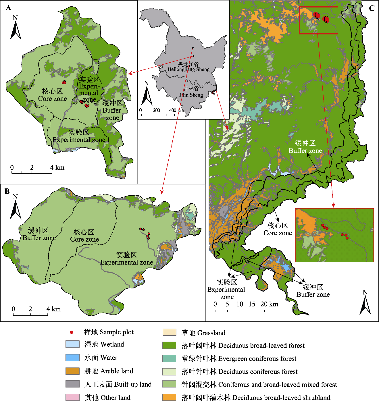
Fig. 1 Location of the northeast forest study area. A, Liangshui National Nature Reserve. B, Fenglin National Nature Reserve. C, Hunchun National Nature Reserve.
| 样地 Sample plot | 地理位置 Geographical position | 郁闭度 Crown density | 物种丰富度 Number of species | Shannon-Wiener多样性指数 Shannon-Wiener diversity index | Simpson多样性指数 Simpson diversity index |
|---|---|---|---|---|---|
| 1 | 129.19° E, 48.12° N | 0.85 | 6 | 1.56 | 0.76 |
| 2 | 129.19° E, 48.12° N | 0.75 | 10 | 1.89 | 0.82 |
| 3 | 129.19° E, 48.12° N | 0.80 | 7 | 1.67 | 0.79 |
| 4 | 129.18° E, 48.13° N | 0.85 | 10 | 1.92 | 0.82 |
| 5 | 129.18° E, 48.13° N | 0.75 | 10 | 1.96 | 0.83 |
| 6 | 131.11° E, 43.44° N | 0.70 | 11 | 0.87 | 0.83 |
| 7 | 131.11° E, 43.44° N | 0.60 | 10 | 0.88 | 0.85 |
| 8 | 131.11° E, 43.44° N | 0.65 | 8 | 0.77 | 0.78 |
| 9 | 131.07° E, 43.47° N | 0.60 | 6 | 0.65 | 0.74 |
| 10 | 131.07° E, 43.47° N | 0.70 | 4 | 0.44 | 0.56 |
| 11 | 131.07° E, 43.47° N | 0.60 | 8 | 0.73 | 0.74 |
| 12 | 128.90° E, 47.18° N | 0.60 | 5 | 1.34 | 0.80 |
| 13 | 128.89° E, 47.18° N | 0.70 | 7 | 1.27 | 0.66 |
| 14 | 128.89° E, 47.18° N | 0.70 | 6 | 1.56 | 0.82 |
| 15 | 128.89° E, 47.18° N | 0.65 | 7 | 1.01 | 0.73 |
| 16 | 128.89° E, 47.19° N | 0.60 | 6 | 1.17 | 0.72 |
| 17 | 128.89° E, 47.18° N | 0.60 | 4 | 0.96 | 0.67 |
| 18 | 128.86° E, 47.20° N | 0.70 | 10 | 2.06 | 0.86 |
| 19 | 128.86° E, 47.20° N | 0.70 | 11 | 2.17 | 0.84 |
| 20 | 128.86° E, 47.20° N | 0.70 | 9 | 1.82 | 0.79 |
Table 1 Sample plot survey information of northeast forest
| 样地 Sample plot | 地理位置 Geographical position | 郁闭度 Crown density | 物种丰富度 Number of species | Shannon-Wiener多样性指数 Shannon-Wiener diversity index | Simpson多样性指数 Simpson diversity index |
|---|---|---|---|---|---|
| 1 | 129.19° E, 48.12° N | 0.85 | 6 | 1.56 | 0.76 |
| 2 | 129.19° E, 48.12° N | 0.75 | 10 | 1.89 | 0.82 |
| 3 | 129.19° E, 48.12° N | 0.80 | 7 | 1.67 | 0.79 |
| 4 | 129.18° E, 48.13° N | 0.85 | 10 | 1.92 | 0.82 |
| 5 | 129.18° E, 48.13° N | 0.75 | 10 | 1.96 | 0.83 |
| 6 | 131.11° E, 43.44° N | 0.70 | 11 | 0.87 | 0.83 |
| 7 | 131.11° E, 43.44° N | 0.60 | 10 | 0.88 | 0.85 |
| 8 | 131.11° E, 43.44° N | 0.65 | 8 | 0.77 | 0.78 |
| 9 | 131.07° E, 43.47° N | 0.60 | 6 | 0.65 | 0.74 |
| 10 | 131.07° E, 43.47° N | 0.70 | 4 | 0.44 | 0.56 |
| 11 | 131.07° E, 43.47° N | 0.60 | 8 | 0.73 | 0.74 |
| 12 | 128.90° E, 47.18° N | 0.60 | 5 | 1.34 | 0.80 |
| 13 | 128.89° E, 47.18° N | 0.70 | 7 | 1.27 | 0.66 |
| 14 | 128.89° E, 47.18° N | 0.70 | 6 | 1.56 | 0.82 |
| 15 | 128.89° E, 47.18° N | 0.65 | 7 | 1.01 | 0.73 |
| 16 | 128.89° E, 47.19° N | 0.60 | 6 | 1.17 | 0.72 |
| 17 | 128.89° E, 47.18° N | 0.60 | 4 | 0.96 | 0.67 |
| 18 | 128.86° E, 47.20° N | 0.70 | 10 | 2.06 | 0.86 |
| 19 | 128.86° E, 47.20° N | 0.70 | 11 | 2.17 | 0.84 |
| 20 | 128.86° E, 47.20° N | 0.70 | 9 | 1.82 | 0.79 |
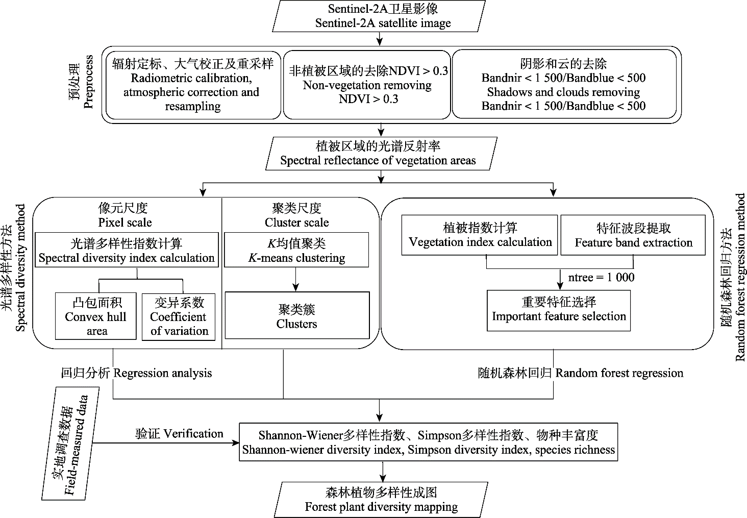
Fig. 2 Flow chart of the research methods for forest plant diversity in northeast China. NDVI, normalized difference vegetation index.
| 植被指数 Vegetation index | 计算公式 Calculate formula | 参考文献 Reference |
|---|---|---|
| TCARI | 3[(R699.19 - R668.98) - 0.2(R699.19 - R550.67)(R699.19/R668.98)] | Kim et al., |
| OSAVI | (1 + 0.16)(R750 - R705)/(R750 + R705 + 0.16) | Wu et al., |
| OSAVI2 | (1 + 0.16)(R800 - R670)/(R800 + R670 + 0.16) | Rondeaux et al., |
| DATT | (R850 - R710)/(R850 - R680) | Datt, |
| DATT2 | R850/R710 | Datt, |
| Gitelson | 1/R700 | Gitelson et al., |
| SR1 | R750/R700 | Gitelson & Merzlyak, |
| SR2 | R700/R670 | McMurtrey III et al., |
| SR3 | R730/R706 | Zarco-Tejada et al., |
| SR4 | R675/R700 | Gitelson et al., |
| MSI | R1600/R819 | Hunt & Rock, |
| NDII | (R819 - R1649)/(R819 + R1649) | Hardisky et al., |
| CRI1 | 1/R510 - 1/R550 | Gitelson et al., |
| CRI2 | 1/R510 - 1/R700 | Gitelson et al., |
| ARI | 1/R550 - 1/R700 | Sims & Gamon, |
| PSRI | (R680 - R500)/R750 | Merzlyak et al., |
| NDVI | (R750.66 - R704.6)/(R750.66 + R704.6) | Gitelson & Merzlyak, |
| GNDVI | (R783 - R560)/(R783 + R560) | Rozenstein et al., |
| TNDVI | ((R842 - R665)/(R842 + R665) + 0.5)^0.5 | Rozenstein et al., |
| WDVI | R842 - R665 × 0.5 | Rozenstein et al., |
| NDI45 | (R705 - R665)/(R705 + R665) | Delegido et al., |
| SAVI | (1 + L) × (R799.09 - R680.045)/(R799.09 + R680.045 + L) (L = 0.5) | Huete, |
| SAVI2 | R799.09/(R680.045+ b/a) (a = 0.969 1, b = 0.084 726) | Major et al., |
| ARVI | RB = R680.045 - r(R444.5 - R680.045) (r = 1) ARVI = (R799.09 - RB)/(R799.09 + RB) | Kaufman & Tanre, |
| SARVI | RB = R680.045 - r(R444.5 - R680.045) (r = 1, L = 0.5) SARVI = (1 + L)(R799.09 - RB)/(R799.09 + RB + L) | Kaufman & Tanre, |
| EVI | G(R799.09 - R680.045)/(R799.09 + C1R680.045 - C2R444.5 + L) (G = 2.5, C1 = 6, C2 = 7.5, L = 1) | Huete et al., |
| IRECI | (R783 - R665)/(R705/R740) | Frampton et al., |
| IPVI | R842/(R842 + R665) | Rozenstein et al., |
| PSSRA | R783/R665 | Rozenstein et al., |
| RVI | R842/R665 | Rozenstein et al., |
Table 2 Formula of calculating vegetation index
| 植被指数 Vegetation index | 计算公式 Calculate formula | 参考文献 Reference |
|---|---|---|
| TCARI | 3[(R699.19 - R668.98) - 0.2(R699.19 - R550.67)(R699.19/R668.98)] | Kim et al., |
| OSAVI | (1 + 0.16)(R750 - R705)/(R750 + R705 + 0.16) | Wu et al., |
| OSAVI2 | (1 + 0.16)(R800 - R670)/(R800 + R670 + 0.16) | Rondeaux et al., |
| DATT | (R850 - R710)/(R850 - R680) | Datt, |
| DATT2 | R850/R710 | Datt, |
| Gitelson | 1/R700 | Gitelson et al., |
| SR1 | R750/R700 | Gitelson & Merzlyak, |
| SR2 | R700/R670 | McMurtrey III et al., |
| SR3 | R730/R706 | Zarco-Tejada et al., |
| SR4 | R675/R700 | Gitelson et al., |
| MSI | R1600/R819 | Hunt & Rock, |
| NDII | (R819 - R1649)/(R819 + R1649) | Hardisky et al., |
| CRI1 | 1/R510 - 1/R550 | Gitelson et al., |
| CRI2 | 1/R510 - 1/R700 | Gitelson et al., |
| ARI | 1/R550 - 1/R700 | Sims & Gamon, |
| PSRI | (R680 - R500)/R750 | Merzlyak et al., |
| NDVI | (R750.66 - R704.6)/(R750.66 + R704.6) | Gitelson & Merzlyak, |
| GNDVI | (R783 - R560)/(R783 + R560) | Rozenstein et al., |
| TNDVI | ((R842 - R665)/(R842 + R665) + 0.5)^0.5 | Rozenstein et al., |
| WDVI | R842 - R665 × 0.5 | Rozenstein et al., |
| NDI45 | (R705 - R665)/(R705 + R665) | Delegido et al., |
| SAVI | (1 + L) × (R799.09 - R680.045)/(R799.09 + R680.045 + L) (L = 0.5) | Huete, |
| SAVI2 | R799.09/(R680.045+ b/a) (a = 0.969 1, b = 0.084 726) | Major et al., |
| ARVI | RB = R680.045 - r(R444.5 - R680.045) (r = 1) ARVI = (R799.09 - RB)/(R799.09 + RB) | Kaufman & Tanre, |
| SARVI | RB = R680.045 - r(R444.5 - R680.045) (r = 1, L = 0.5) SARVI = (1 + L)(R799.09 - RB)/(R799.09 + RB + L) | Kaufman & Tanre, |
| EVI | G(R799.09 - R680.045)/(R799.09 + C1R680.045 - C2R444.5 + L) (G = 2.5, C1 = 6, C2 = 7.5, L = 1) | Huete et al., |
| IRECI | (R783 - R665)/(R705/R740) | Frampton et al., |
| IPVI | R842/(R842 + R665) | Rozenstein et al., |
| PSSRA | R783/R665 | Rozenstein et al., |
| RVI | R842/R665 | Rozenstein et al., |
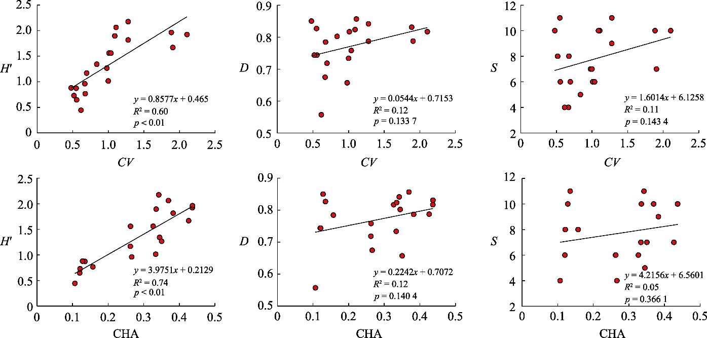
Fig. 3 Relationship between coefficient of variation (CV) and convex hull area (CHA) based on original bands and measured plant diversity (Shannon-Wiener diversity index (H'), Simpson diversity index (D) and species richness (S)).
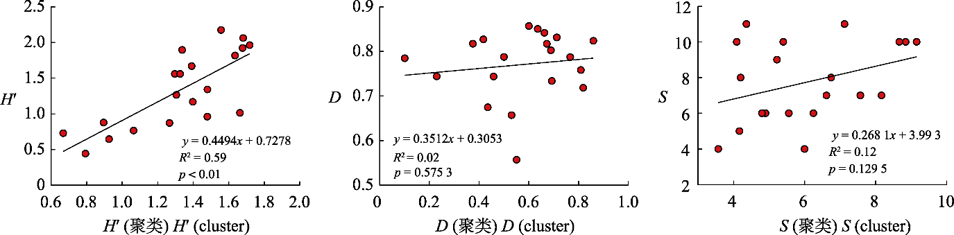
Fig. 4 Relationship between plant diversity index based on clustering (Shannon-Wiener diversity index (H'), Simpson diversity index (D) and the number of spectral species (S)) and measured value.
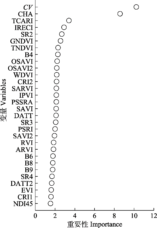
Fig. 5 Top 30 variables of importance in random forest regression. CV, coefficient of variation; CHA, convex hull area; B4, B6, B8 and B9 represent the fourth, sixth, eighth and ninth bands of Sentinel-2A, respectively; the other variables are vegetation indexes, with specific meanings shown in Table 2.
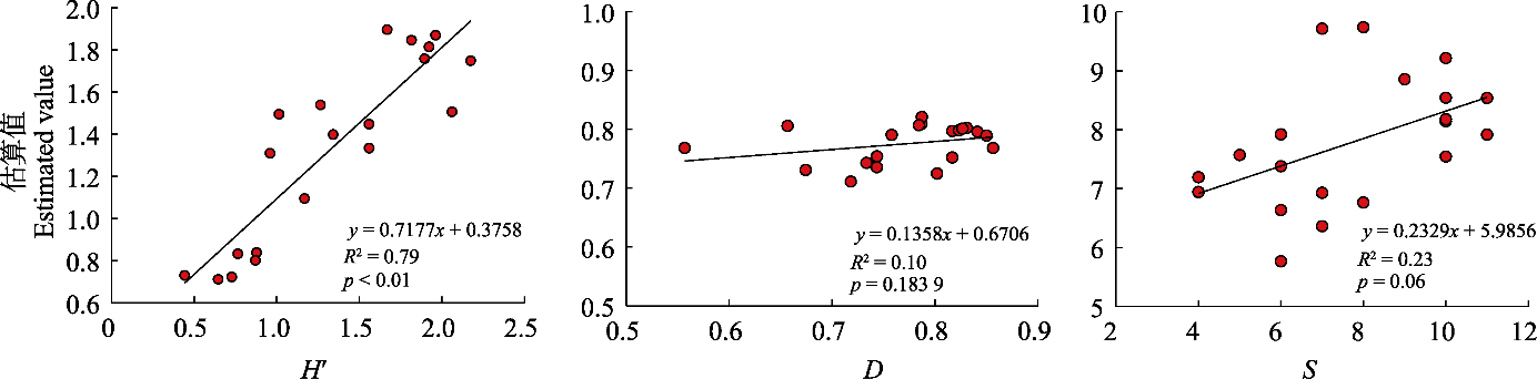
Fig. 6 Estimation of plant diversity index (Shannon-Wiener diversity index (H'), Simpson diversity index (D) and species richness(S)) based on random forest regression.
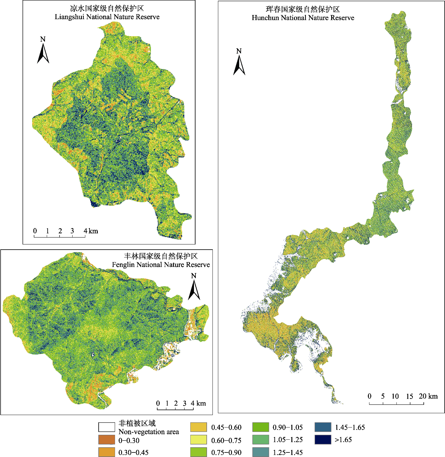
Fig. 7 Spatial distribution of Shannon-Wiener diversity index in three national nature reserves.
| [1] |
Asner GP, Martin RE. (2009). Airborne spectranomics: mapping canopy chemical and taxonomic diversity in tropical forests. Frontiers in Ecology and the Environment, 7, 269-276.
DOI URL |
| [2] |
Asner GP, Martin RE, Knapp DE, Tupayachi R, Anderson CB, Sinca F, Vaughn NR, Llactayo W. (2017). Airborne laser-guided imaging spectroscopy to map forest trait diversity and guide conservation. Science, 355, 385-389.
DOI PMID |
| [3] |
Breiman L. (2001). Random forests. Machine Learning, 45, 5-32.
DOI URL |
| [4] |
Carlson KM, Asner GP, Hughes RF, Ostertag R, Martin RE. (2007). Hyperspectral remote sensing of canopy biodiversity in Hawaiian lowland rainforests. Ecosystems, 10, 536-549.
DOI URL |
| [5] |
Ceballos G, Ehrlich PR, Barnosky AD, García A, Pringle RM, Palmer TM. (2015). Accelerated modern human-induced species losses: entering the sixth mass extinction. Science Advances, 1, e1400253. DOI: 10.1126/sciadv.1400253.
DOI |
| [6] |
Chang CI. (2000). An information-theoretic approach to spectral variability, similarity, and discrimination for hyperspectral image analysis. IEEE Transactions on Information Theory, 46, 1927-1932.
DOI URL |
| [7] |
Chrysafis I, Korakis G, Kyriazopoulos AP, Mallinis G. (2020). Predicting tree species diversity using geodiversity and Sentinel-2 multi-seasonal spectral information. Sustainability, 12, 9250. DOI: 10.3390/su12219250.
DOI |
| [8] |
Clark ML, Roberts DA. (2012). Species-level differences in hyperspectral metrics among tropical rainforest trees as determined by a tree-based classifier. Remote Sensing, 4, 1820-1855.
DOI URL |
| [9] |
Cross M, Scambos T, Pacifici F, Vargas-Ramirez O, Moreno- Sanchez R, Marshall W. (2019). Classification of tropical forest tree species using meter-scale image data. Remote Sensing, 11, 1411. DOI: 10.3390/rs11121411.
DOI |
| [10] | Dahlin KM. (2016). Spectral diversity area relationships for assessing biodiversity in a wildland-agriculture matrix. Ecological Applications, 26, 2756-2766. |
| [11] |
Datt B. (1999). Visible/near infrared reflectance and chlorophyll content in Eucalyptus leaves. International Journal of Remote Sensing, 20, 2741-2759.
DOI URL |
| [12] |
Delegido J, Verrelst J, Alonso L, Moreno J. (2011). Evaluation of Sentinel-2 red-edge bands for empirical estimation of green LAI and chlorophyll content. Sensors, 11, 7063-7081.
DOI PMID |
| [13] |
Deng S, Katoh M, Yu X, Hyyppa J, Gao T. (2016). Comparison of tree species classifications at the individual tree level by combining ALS data and RGB images using different algorithms. Remote Sensing, 8, 1034. DOI: 10.3390/rs8121034.
DOI |
| [14] | Dong WX, Zeng Y, Zhao YJ, Zhao D, Zheng ZJ, Yi HY. (2018). Forest species diversity mapping using airborne LiDAR and hyperspectral data. Journal of Remote Sensing, 22, 833-847. |
| [董文雪, 曾源, 赵玉金, 赵旦, 郑朝菊, 衣海燕 (2018). 机载激光雷达及高光谱的森林乔木物种多样性遥感监测. 遥感学报, 22, 833-847.] | |
| [15] |
Duro DC, Coops NC, Wulder MA, Han T. (2007). Development of a large area biodiversity monitoring system driven by remote sensing. Progress in Physical Geography: Earth and Environment, 31, 235-260.
DOI URL |
| [16] |
Edwards JA, Santos-Medellin CM, Liechty ZS, Nguyen B, Lurie E, Eason S, Phillips G, Sundaresan V. (2018). Compositional shifts in root-associated bacterial and archaeal microbiota track the plant life cycle in field-grown rice. PLOS Biology, 16, e2003862. DOI: 10.1371/journal.pbio.2003862.
DOI |
| [17] |
Erinjery JJ, Singh M, Kent R. (2018). Mapping and assessment of vegetation types in the tropical rainforests of the Western Ghats using multispectral Sentinel-2 and SAR Sentinel-1 satellite imagery. Remote Sensing of Environment, 216, 345-354.
DOI URL |
| [18] |
Fairbanks DHK, McGwire KC. (2004). Patterns of floristic richness in vegetation communities of California: regional scale analysis with multi-temporal NDVI. Global Ecology and Biogeography, 13, 221-235.
DOI URL |
| [19] |
Fauvel M, Lopes M, Dubo T, Rivers-Moore J, Frison PL, Gross N, Ouin A. (2020). Prediction of plant diversity in grasslands using Sentinel-1 and -2 satellite image time series. Remote Sensing of Environment, 237, 111536. DOI: 10.1016/j.rse.2019.111536.
DOI |
| [20] |
Feeley KJ, Gillespie TW, Terborgh JW. (2005). The utility of spectral indices from Landsat ETM+ for measuring the structure and composition of tropical dry forests. Biotropica, 37, 508-519.
DOI URL |
| [21] |
Féret JB, Asner GP. (2014). Mapping tropical forest canopy diversity using high-fidelity imaging spectroscopy. Ecological Applications, 24, 1289-1296.
DOI URL |
| [22] |
Féret JB, de Boissieu F (2020). biodivMapR: an R package for α- and β-diversity mapping using remotely sensed images. Methods in Ecology and Evolution, 11, 64-70.
DOI URL |
| [23] |
Frampton WJ, Dash J, Watmough G, Milton EJ. (2013). Evaluating the capabilities of Sentinel-2 for quantitative estimation of biophysical variables in vegetation. ISPRS Journal of Photogrammetry and Remote Sensing, 82, 83-92.
DOI URL |
| [24] |
Genuer R, Poggi JM, Tuleau-Malot C. (2010). Variable selection using Random forests. Pattern Recognition Letters, 31, 2225-2236.
DOI URL |
| [25] |
Gholizadeh H, Gamon JA, Helzer CJ, Cavender-Bares J. (2020). Multi-temporal assessment of grassland α- and β-diversity using hyperspectral imaging. Ecological Applications, 30, e02145. DOI: 10.1002/eap.2145.
DOI |
| [26] |
Gholizadeh H, Gamon JA, Townsend PA, Zygielbaum AI, Helzer CJ, Hmimina GY, Yu R, Moore RM, Schweiger AK, Cavender-Bares J. (2019). Detecting prairie biodiversity with airborne remote sensing. Remote Sensing of Environment, 221, 38-49.
DOI |
| [27] |
Gholizadeh H, Gamon JA, Zygielbaum AI, Wang R, Schweiger AK, Cavender-Bares J. (2018). Remote sensing of biodiv improve ersity: soil correction and data dimension reduction methods assessment of α-diversity (species richness) in prairie ecosystems. Remote Sensing of Environment, 206, 240-253.
DOI URL |
| [28] |
Gillespie TW, Foody GM, Rocchini D, Giorgi AP, Saatchi S. (2008). Measuring and modelling biodiversity from space. Progress in Physical Geography: Earth and Environment, 32, 203-221.
DOI URL |
| [29] |
Gitelson A, Merzlyak MN. (1994). Quantitative estimation of chlorophyll-a using reflectance spectra: experiments with autumn chestnut and maple leaves. Journal of Photochemistry and Photobiology B: Biology, 22, 247-252.
DOI URL |
| [30] |
Gitelson AA, Buschmann C, Lichtenthaler HK. (1999). The chlorophyll fluorescence ratio F735/F700 as an accurate measure of the chlorophyll content in plants. Remote Sensing of Environment, 69, 296-302.
DOI URL |
| [31] |
Gitelson AA, Gritz Y, Merzlyak MN. (2003). Relationships between leaf chlorophyll content and spectral reflectance and algorithms for non-destructive chlorophyll assessment in higher plant leaves. Journal of Plant Physiology, 160, 271-282.
DOI PMID |
| [32] |
Gitelson AA, Merzlyak MN. (1997). Remote estimation of chlorophyll content in higher plant leaves. International Journal of Remote Sensing, 18, 2691-2697.
DOI URL |
| [33] |
Gitelson AA, Zur Y, Chivkunova OB, Merzlyak MN. (2002). Assessing carotenoid content in plant leaves with reflectance spectroscopy. Photochemistry and Photobiology, 75, 272-281.
DOI PMID |
| [34] |
Gotelli NJ, Colwell RK. (2001). Quantifying biodiversity: procedures and pitfalls in the measurement and comparison of species richness. Ecology Letters, 4, 379-391.
DOI URL |
| [35] |
Graham CH, Hijmans RJ. (2006). A comparison of methods for mapping species ranges and species richness. Global Ecology and Biogeography, 15, 578-587.
DOI URL |
| [36] |
Gyamfi-Ampadu E, Gebreslasie M, Mendoza-Ponce A. (2021). Evaluating multi-sensors spectral and spatial resolutions for tree species diversity prediction. Remote Sensing, 13, 1033. DOI: 10.3390/rs13051033.
DOI |
| [37] | Hardisky M, Klemas V, Smart RM. (1983). The influence of soil-salinity, growth form, and leaf moisture on the spectral radiance of Spartina alterniflora canopies. Photogrammetric Engineering and Remote Sensing, 48, 77-84. |
| [38] |
Harrison PA, Berry PM, Simpson G, Haslett JR, Blicharska M, Bucur M, Dunford R, Egoh B, Garcia-Llorente M, Geamănă N, Geertsema W, Lommelen E, Meiresonne L, Turkelboom F. (2014). Linkages between biodiversity attributes and ecosystem services: a systematic review. Ecosystem Services, 9, 191-203.
DOI URL |
| [39] |
Hauser LT, Féret JB, An Binh N, van der Windt N, Sil AF, Timmermans J, Soudzilovskaia NA, van Bodegom PM. (2021). Towards scalable estimation of plant functional diversity from Sentinel-2: in-situ validation in a heterogeneous (semi-)natural landscape. Remote Sensing of Environment, 262, 112505. DOI: 10.1016/j.rse.2021.112505.
DOI |
| [40] |
Huete AR. (1988). A soil-adjusted vegetation index (SAVI). Remote Sensing of Environment, 25, 295-309.
DOI URL |
| [41] |
Huete AR, Liu HQ, Batchily K, Vanleeuwen W. (1997). A comparison of vegetation indices over a global set of TM images for EOS-MODIS. Remote Sensing of Environment, 59, 440-451.
DOI URL |
| [42] |
Hunt Jr ER, Rock BN. (1989). Detection of changes in leaf water content using Near- and Middle-Infrared reflectances. Remote Sensing of Environment, 30, 43-54.
DOI URL |
| [43] |
Jetz W, Cavender-Bares J, Pavlick R, Schimel D, Davis FW, Asner GP, Guralnick R, Kattge J, Latimer AM, Moorcroft P, Schaepman ME, Schildhauer MP, Schneider FD, Schrodt F, Stahl U, Ustin SL. (2016). Monitoring plant functional diversity from space. Nature Plants, 2, 16024. DOI: 10.1038/NPLANTS.2016.24.
DOI |
| [44] |
Kalacska M, Sanchez-Azofeifa GA, Rivard B, Caelli T, White HP, Calvo-Alvarado JC. (2007). Ecological fingerprinting of ecosystem succession: estimating secondary tropical dry forest structure and diversity using imaging spectroscopy. Remote Sensing of Environment, 108, 82-96.
DOI URL |
| [45] |
Kaufman YJ, Tanre D. (1992). Atmospherically resistant vegetation index (ARVI) for EOS-MODIS. IEEE Transactions on Geoscience and Remote Sensing, 30, 261-270.
DOI URL |
| [46] |
Ke YH, Quackenbush LJ, Im J. (2010). Synergistic use of QuickBird multispectral imagery and LIDAR data for object-based forest species classification. Remote Sensing of Environment, 114, 1141-1154.
DOI URL |
| [47] |
Kerr JT, Ostrovsky M. (2003). From space to species: ecological applications for remote sensing. Trends in Ecology & Evolution, 18, 299-305.
DOI URL |
| [48] | Kim MS, Daughtry CST, Chappelle EW, McMurtrey JE, Walthall CL. (1994). The use of high spectral resolution bands for estimating absorbed photosynthetically active radiation (a Par)//Proceedings of the 6th International Symposium on Physical Measurements and Signatures in Remote Sensing. Val dʼIsère, France. 299-306. |
| [49] |
Laliberté E, Schweiger AK, Legendre P. (2020). Partitioning plant spectral diversity into alpha and beta components. Ecology Letters, 23, 370-380.
DOI PMID |
| [50] |
Levrel H, Fontaine B, Henry PY, Jiguet F, Julliard R, Kerbiriou C, Couvet D. (2010). Balancing state and volunteer investment in biodiversity monitoring for the implementation of CBD indicators: a French example. Ecological Economics, 69, 1580-1586.
DOI URL |
| [51] |
Lucas KL, Carter GA. (2008). The use of hyperspectral remote sensing to assess vascular plant species richness on Horn Island, Mississippi. Remote Sensing of Environment, 112, 3908-3915.
DOI URL |
| [52] |
Ma X, Mahecha MD, Migliavacca M, van der Plas F, Benavides R, Ratcliffe S, Kattge J, Richter R, Musavi T, Baeten L, Barnoaiea I, Bohn FJ, Bouriaud O, Bussotti F, Coppi A, et al. (2019). Inferring plant functional diversity from space: the potential of Sentinel-2. Remote Sensing of Environment, 233, 111368. DOI: 10.1016/j.rse.2019.111368.
DOI |
| [53] |
Ma Z, Li B, Li WJ, Han NY, Chen JK, Watkinson AR. (2009). Conflicts between biodiversity conservation and development in a biosphere reserve. Journal of Applied Ecology, 46, 527-535.
DOI URL |
| [54] |
Major DJ, Baret F, Guyot G. (1990). A ratio vegetation index adjusted for soil brightness. International Journal of Remote Sensing, 11, 727-740.
DOI URL |
| [55] |
Mallinis G, Chrysafis I, Korakis G, Pana E, Kyriazopoulos AP. (2020). A random forest modelling procedure for a multi-sensor assessment of tree species diversity. Remote Sensing, 12, 1210. DOI: 10.3390/rs12071210.
DOI |
| [56] |
Marceau DJ, Gratton DJ, Fournier RA, Fortin JP. (1994). Remote sensing and the measurement of geographical entities in a forested environment. 2. The optimal spatial resolution. Remote Sensing of Environment, 49, 105-117.
DOI URL |
| [57] |
McMurtrey III JE, Chappelle EW, Kim MS, Meisinger JJ, Corp LA. (1994). Distinguishing nitrogen fertilization levels in field corn (Zea mays L.) with actively induced fluorescence and passive reflectance measurements. Remote Sensing of Environment, 47, 36-44.
DOI URL |
| [58] |
Medina O, Manian V, Chinea JD. (2013). Biodiversity assessment using hierarchical agglomerative clustering and spectral unmixing over hyperspectral images. Sensors, 13, 13949-13959.
DOI PMID |
| [59] |
Merzlyak MN, Gitelson AA, Chivkunova OB, Rakitin VY. (1999). Non-destructive optical detection of pigment changes during leaf senescence and fruit ripening. Physiologia Plantarum, 106, 135-141.
DOI URL |
| [60] |
Miao X, Heaton JS, Zheng S, Charlet DA, Liu H. (2012). Applying tree-based ensemble algorithms to the classification of ecological zones using multi-temporal multi- source remote-sensing data. International Journal of Remote Sensing, 33, 1823-1849.
DOI URL |
| [61] |
Nagendra H. (2001). Using remote sensing to assess biodiversity. International Journal of Remote Sensing, 22, 2377-2400.
DOI URL |
| [62] |
Nagendra H, Rocchini D. (2008). High resolution satellite imagery for tropical biodiversity studies: the devil is in the detail. Biodiversity and Conservation, 17, 3431-3442.
DOI URL |
| [63] |
Nicholson E, Mace GM, Armsworth PR, Atkinson G, Buckle S, Clements T, Ewers RM, Fa JE, Gardner TA, Gibbons J, Grenyer R, Metcalfe R, Mourato S, Muûls M, Osborn D, et al. (2009). Priority research areas for ecosystem services in a changing world. Journal of Applied Ecology, 46, 1139-1144.
DOI URL |
| [64] |
Oldeland J, Wesuls D, Rocchini D, Schmidt M, Jürgens N. (2010). Does using species abundance data improve estimates of species diversity from remotely sensed spectral heterogeneity? Ecological Indicators, 10, 390-396.
DOI URL |
| [65] |
Palmer MW, Earls PG, Hoagland BW, White PS, Wohlgemuth T. (2002). Quantitative tools for perfecting species lists. Environmetrics, 13, 121-137.
DOI URL |
| [66] |
Pan Y, Birdsey RA, Phillips OL, Jackson RB. (2013). The structure, distribution, and biomass of the worldʼs forests. Annual Review of Ecology, Evolution, and Systematics, 44, 593-622.
DOI URL |
| [67] |
Pereira HM, Belnap J, Brummitt N, Collen B, Ding H, Gonzalez- Espinosa M, Gregory RD, Honrado J, Jongman RHG, Julliard R, McRae L, Proenca V, Rodrigues P, Opige M, Rodriguez JP, et al. (2010). Global biodiversity monitoring. Frontiers in Ecology and the Environment, 8, 459-460.
DOI URL |
| [68] |
Pielou EC. (1966). The measurement of diversity in different types of biological collections. Journal of Theoretical Biology, 13, 131-144.
DOI URL |
| [69] |
Rocchini D. (2007). Effects of spatial and spectral resolution in estimating ecosystem α-diversity by satellite imagery. Remote Sensing of Environment, 111, 423-434.
DOI URL |
| [70] |
Rocchini D, Balkenhol N, Carter GA, Foody GM, Gillespie TW, He KS, Kark S, Levin N, Lucas K, Luoto M, Nagendra H, Oldeland J, Ricotta C, Southworth J, Neteler M. (2010). Remotely sensed spectral heterogeneity as a proxy of species diversity: recent advances and open challenges. Ecological Informatics, 5, 318-329.
DOI URL |
| [71] |
Rondeaux G, Steven M, Baret F. (1996). Optimization of soil- adjusted vegetation indices. Remote Sensing of Environment, 55, 95-107.
DOI URL |
| [72] |
Rossi C, Kneubüler M, Schütz M, Schaepman ME, Haller RM, Risch AC. (2020). From local to regional: functional diversity in differently managed alpine grasslands. Remote Sensing of Environment, 236, 111415. DOI: 10.1016/j.rse.2019.111415.
DOI |
| [73] |
Rozenstein O, Haymann N, Kaplan G, Tanny J. (2019). Validation of the cotton crop coefficient estimation model based on Sentinel-2 imagery and eddy covariance measurements. Agricultural Water Management, 223, 105715. DOI: 10.1016/j.agwat.2019.105715.
DOI |
| [74] |
Ruiz-Benito P, Gómez-Aparicio L, Paquette A, Messier C, Kattge J, Zavala MA. (2014). Diversity increases carbon storage and tree productivity in Spanish forests. Global Ecology and Biogeography, 23, 311-322.
DOI URL |
| [75] |
Schäfer E, Heiskanen J, Heikinheimo V, Pellikka P. (2016). Mapping tree species diversity of a tropical montane forest by unsupervised clustering of airborne imaging spectroscopy data. Ecological Indicators, 64, 49-58.
DOI URL |
| [76] |
Schneider FD, Morsdorf F, Schmid B, Petchey OL, Hueni A, Schimel DS, Schaepman ME. (2017). Mapping functional diversity from remotely sensed morphological and physiological forest traits. Nature Communications, 8, 1441. DOI: 10.1038/s41467-017-01530-3.
DOI |
| [77] | Schweiger AK, Cavender-Bares J, Townsend PA, Hobbie SE, Madritch MD, Wang R, Tilman D, Gamon JA. (2018). Plant spectral diversity integrates functional and phylogenetic components of biodiversity and predicts ecosystem function. Nature Ecology & Evolution, 2, 976-982. |
| [78] |
Sims DA, Gamon JA. (2002). Relationships between leaf pigment content and spectral reflectance across a wide range of species, leaf structures and developmental stages. Remote Sensing of Environment, 81, 337-354.
DOI URL |
| [79] |
Somers B, Asner GP, Martin RE, Anderson CB, Knapp DE, Wright SJ, van de Kerchove R (2015). Mesoscale assessment of changes in tropical tree species richness across a bioclimatic gradient in Panama using airborne imaging spectroscopy. Remote Sensing of Environment, 167, 111-120.
DOI URL |
| [80] |
Tilman D, Knops J, Wedin D, Reich P, Ritchie M, Siemann E. (1997). The influence of functional diversity and composition on ecosystem processes. Science, 277, 1300-1302.
DOI URL |
| [81] |
Torresani M, Rocchini D, Sonnenschein R, Zebisch M, Marcantonio M, Ricotta C, Tonon G. (2019). Estimating tree species diversity from space in an alpine conifer forest: the Raoʼs Q diversity index meets the spectral variation hypothesis. Ecological Informatics, 52, 26-34.
DOI |
| [82] |
Turner W. (2014). Sensing biodiversity. Science, 346, 301-302.
DOI PMID |
| [83] |
Turner W, Spector S, Gardiner N, Fladeland M, Sterling E, Steininger M. (2003). Remote sensing for biodiversity science and conservation. Trends in Ecology & Evolution, 18, 306-314.
DOI URL |
| [84] |
Ustin SL, Gamon JA. (2010). Remote sensing of plant functional types. New Phytologist, 186, 795-816.
DOI PMID |
| [85] |
Wang R, Gamon JA. (2019). Remote sensing of terrestrial plant biodiversity. Remote Sensing of Environment, 231, 111128. DOI: 10.1016/j.rse.2019.111218.
DOI |
| [86] |
Wang R, Gamon JA, Emmerton CA, Li H, Nestola E, Pastorello GZ, Menzer O. (2016). Integrated analysis of productivity and biodiversity in a southern Alberta prairie. Remote Sensing, 8, 214. DOI: 10.3390/rs8030214.
DOI |
| [87] |
Wang R, Gamon JA, Schweiger AK, Cavender-Bares J, Townsend PA, Zygielbaum AI, Kothari S. (2018). Influence of species richness, evenness, and composition on optical diversity: a simulation study. Remote Sensing of Environment, 211, 218-228.
DOI URL |
| [88] |
Waring RH, Coops NC, Fan W, Nightingale JM. (2006). MODIS enhanced vegetation index predicts tree species richness across forested ecoregions in the contiguous USA. Remote Sensing of Environment, 103, 218-226.
DOI URL |
| [89] |
Wu CY, Niu Z, Tang Q, Huang WJ. (2008). Estimating chlorophyll content from hyperspectral vegetation indices: modeling and validation. Agricultural and Forest Meteorology, 148, 1230-1241.
DOI URL |
| [90] |
Xi YB, Ren CY, Wang ZM, Wei SQ, Bai JL, Zhang B, Xiang HX, Chen L. (2019). Mapping tree species composition using OHS-1 hyperspectral data and deep learning algorithms in Changbai Mountains, northeast China. Forests, 10, 818. DOI: 10.3390/f10090818.
DOI |
| [91] |
Xu W, Li X, Pimm SL, Hull V, Zhang J, Zhang L, Xiao Y, Zheng H, Ouyang Z. (2016). The effectiveness of the zoning of Chinaʼs protected areas. Biological Conservation, 204, 231-236.
DOI URL |
| [92] |
Yi HY, Zeng Y, Zhao YJ, Zheng ZJ, Xiong J, Zhao D. (2020). Forest species diversity mapping based on clustering algorithm. Chinese Journal of Plant Ecology, 44, 598-615.
DOI URL |
|
[衣海燕, 曾源, 赵玉金, 郑朝菊, 熊杰, 赵旦 (2020). 利用聚类算法监测森林乔木物种多样性. 植物生态学报, 44, 598-615.]
DOI |
|
| [93] |
Zarco-Tejada PJ, Pushnik JC, Dobrowski S, Ustin SL. (2003). Steady-state chlorophyll a fluorescence detection from canopy derivative reflectance and double-peak red-edge effects. Remote Sensing of Environment, 84, 283-294.
DOI URL |
| [94] |
Zhang J, Rivard B, Sánchez-Azofeifa A, Castro-Esau K. (2006). Intra- and inter-class spectral variability of tropical tree species at La Selva, Costa Rica: implications for species identification using HYDICE imagery. Remote Sensing of Environment, 105, 129-141.
DOI URL |
| [95] |
Zhao YJ, Zeng Y, Zheng ZJ, Dong WX, Zhao D, Wu BF, Zhao QJ. (2018). Forest species diversity mapping using airborne LiDAR and hyperspectral data in a subtropical forest in China. Remote Sensing of Environment, 213, 104-114.
DOI URL |
| [96] |
Zheng Z, Zeng Y, Schneider FD, Zhao Y, Zhao D, Schmid D, Schaepman ME, Morsdorf F. (2021). Mapping functional diversity using individual tree-based morphological and physiological traits in a subtropical forest. Remote Sensing of Environment, 252, 112170. DOI: 10.1016/j.rse.2020.112170.
DOI |
| Viewed | ||||||
|
Full text |
|
|||||
|
Abstract |
|
|||||
Copyright © 2026 Chinese Journal of Plant Ecology
Tel: 010-62836134, 62836138, E-mail: apes@ibcas.ac.cn, cjpe@ibcas.ac.cn
![]()