
植物生态学报 ›› 2005, Vol. 29 ›› Issue (2): 185-196.DOI: 10.17521/cjpe.2005.0024
李晓兵, 陈云浩*( ), 余弘婧
收稿日期:2003-12-29
接受日期:2004-05-15
出版日期:2005-12-29
发布日期:2005-03-10
通讯作者:
陈云浩
作者简介:*E-mail: cyh@bnu.edu.cn基金资助:
LI Xiao-Bing, CHEN Yun-Hao*(), YU Hong-Jing
Received:2003-12-29
Accepted:2004-05-15
Online:2005-12-29
Published:2005-03-10
Contact:
CHEN Yun-Hao
摘要:
着重探讨了建立中国东北样带 (NortheastChinatransect, NECT) 土地覆盖特征数据集的原理、方法及其在全球变化研究方面的重要应用。NECT土地覆盖特征数据集是以多时相的 1km分辨率的NOAA/AVHRR归一化植被指数NDVI (Normalizeddifferencevegetationindex) 数字影像为基础, 同时采用高程、气候、土壤、植被、土地利用、土地资源、生态区域、行政边界、经济、社会等多源数据作为数据源, 并经过标准化处理 (如数字化、空间插值、几何配准、投影转换 ) 集成而成。在土地覆盖特征数据集的主要应用方面, 如 :1) 利用多时相、1km分辨率的NOAA/AVHRR影像完成了中国东北样带土地覆盖分类图。一级分类系统包括森林、草原、荒漠和沙地、灌丛、农田、混合覆盖 类型、城镇和水体等 8类, 二级分类体系包括 12类。经过地面采样进行精度检验, 分类精度达到 81.6 1%。 2 ) 对主要植被类型的植物生长季变化进行的研究。利用多时相的遥感影像构造了能够反映植被年际、季节生长变化的遥感植被指数ND VImax、NDVI变幅xam以及NDVI的标准偏差x′s 等, 分析这 3个参数 1983~ 1999年的 17年中的变化情况。该数据集的建立是研究该样带土地覆盖特征及其变化规律的基础, 对基于样带的全球变化研究有重要的意义。
李晓兵, 陈云浩, 余弘婧. 发展NECT土地覆盖特征数据集的原理、方法和应用. 植物生态学报, 2005, 29(2): 185-196. DOI: 10.17521/cjpe.2005.0024
LI Xiao-Bing, CHEN Yun-Hao, YU Hong-Jing. PRINCIPLES, METHODOLOGIES AND APPLICATION OF REMOTELY SENSED DATA FOR DEVELOPING LAND COVER CHARACTERISTICS DATA SET FOR NECT. Chinese Journal of Plant Ecology, 2005, 29(2): 185-196. DOI: 10.17521/cjpe.2005.0024
| 基本数据类型 Basic data types | 详细内容 Details |
|---|---|
| 土地利用/覆盖变化数据 Data of land use and land cover change | 各 类土地利用/覆盖动态的信息, 包括城市、工业、干旱区与灌溉农业、半天然与天然森林、草地、裸地等自然区域以及保护区等, 还包括通过历史数据推演出来的历史上的LUCC动态信息 Information of land use and land cover change, including natural region and conservation such as cities, industry, arid region, irrigated farming, semi-natural forest and natural forest, grassland, bare soil, and so on, also including historic dynamic information of land use and land cover change through extrapolating historic data |
| 环境数据 Environmental data | 气候数据 (降水、温度、光照、相对湿度等) Climate data (precipitation, temperature, solar irradiation, relative humidity, and so on) |
| 地形数据 (海拔、坡度与方位) Terrain data (altitude, slope, orientation) | |
| 土壤数据 (土壤有机碳、肥力、组织等) Soil data (soil organic carbon, soil fertility, soil fabric, and so on) | |
| 植被数据 (植被盖度、种类、动态) Vegetation data (vegetation fraction, species, dynamics) | |
| 养分传输 Nutrient transmission | |
| 土地资源退化 Land resource degradation | |
| 水资源退化与污染 (地表水与地下水) Water resource degradation and pollution (surface water and ground water) | |
| 经济数据 Economic data | 多部门生产结构 (地区水平上) Multi-section productive structure (region-level) |
| 生 产投入 (技术、农业化肥、劳动力、机械、灌溉等的投入, 在地区水平上) Productive input (input of technology, agriculture fertilizer, labor force, mechanism, irrigation, and so on, in region-level) | |
| 价格、补贴与税收 (省或国家水平上) Price, subsidies and revenue (province-level or country-level) | |
| 基础设施 (能源、交通与电信) Foundation establishment (energy sources, traffic and telecom) | |
| 社会数据 Social data | 人口普查数据与空间分布模式 (地区水平上) Census data and distribution 收入分配 (地区水平上) Income distribution (region-level) |
| 迁移 (国际间与省之间) Transference (international and provincial) | |
| 制度 (土地占有权、水权等) Regime (soil possess rights, water rights) | |
| 健康 (实际/潜在性疾病发生率的地区分布) Health (area distribution of actual/potential disease occur rate) | |
| 全球与区域尺度上LUCC驱动力数据 Driving force data of LUCC in global and regional scale | 人口增长、人口结构与迁移的变化 Change of population increasing, population structure and transference |
| 能源、产品与舒适的追求 (消费模式、游憩) Pursue of energy sources, products and comfort (consumption pattern, relaxation) | |
| 生活方式与城乡间的相互关系 Interrelation of lifestyle with urban and rural | |
| 自然条件中的极端事件与变化性 Extreme event under natural condition and variability | |
| 宏观经济驱动力 Macro-economy driving force | |
| 国家政策措施与指令 Country policy and injunction | |
| 外部驱动力 (贸易全球化、国际协定) Exterior driving force (commercial globalization, international trade) |
表1 土地利用/覆盖变化研究所需基本数据
Table 1 Basic data demanded for research on land use and land cover change
| 基本数据类型 Basic data types | 详细内容 Details |
|---|---|
| 土地利用/覆盖变化数据 Data of land use and land cover change | 各 类土地利用/覆盖动态的信息, 包括城市、工业、干旱区与灌溉农业、半天然与天然森林、草地、裸地等自然区域以及保护区等, 还包括通过历史数据推演出来的历史上的LUCC动态信息 Information of land use and land cover change, including natural region and conservation such as cities, industry, arid region, irrigated farming, semi-natural forest and natural forest, grassland, bare soil, and so on, also including historic dynamic information of land use and land cover change through extrapolating historic data |
| 环境数据 Environmental data | 气候数据 (降水、温度、光照、相对湿度等) Climate data (precipitation, temperature, solar irradiation, relative humidity, and so on) |
| 地形数据 (海拔、坡度与方位) Terrain data (altitude, slope, orientation) | |
| 土壤数据 (土壤有机碳、肥力、组织等) Soil data (soil organic carbon, soil fertility, soil fabric, and so on) | |
| 植被数据 (植被盖度、种类、动态) Vegetation data (vegetation fraction, species, dynamics) | |
| 养分传输 Nutrient transmission | |
| 土地资源退化 Land resource degradation | |
| 水资源退化与污染 (地表水与地下水) Water resource degradation and pollution (surface water and ground water) | |
| 经济数据 Economic data | 多部门生产结构 (地区水平上) Multi-section productive structure (region-level) |
| 生 产投入 (技术、农业化肥、劳动力、机械、灌溉等的投入, 在地区水平上) Productive input (input of technology, agriculture fertilizer, labor force, mechanism, irrigation, and so on, in region-level) | |
| 价格、补贴与税收 (省或国家水平上) Price, subsidies and revenue (province-level or country-level) | |
| 基础设施 (能源、交通与电信) Foundation establishment (energy sources, traffic and telecom) | |
| 社会数据 Social data | 人口普查数据与空间分布模式 (地区水平上) Census data and distribution 收入分配 (地区水平上) Income distribution (region-level) |
| 迁移 (国际间与省之间) Transference (international and provincial) | |
| 制度 (土地占有权、水权等) Regime (soil possess rights, water rights) | |
| 健康 (实际/潜在性疾病发生率的地区分布) Health (area distribution of actual/potential disease occur rate) | |
| 全球与区域尺度上LUCC驱动力数据 Driving force data of LUCC in global and regional scale | 人口增长、人口结构与迁移的变化 Change of population increasing, population structure and transference |
| 能源、产品与舒适的追求 (消费模式、游憩) Pursue of energy sources, products and comfort (consumption pattern, relaxation) | |
| 生活方式与城乡间的相互关系 Interrelation of lifestyle with urban and rural | |
| 自然条件中的极端事件与变化性 Extreme event under natural condition and variability | |
| 宏观经济驱动力 Macro-economy driving force | |
| 国家政策措施与指令 Country policy and injunction | |
| 外部驱动力 (贸易全球化、国际协定) Exterior driving force (commercial globalization, international trade) |
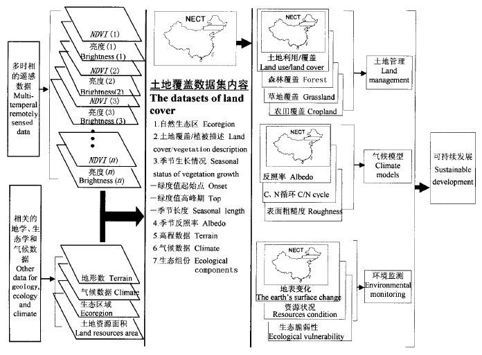
图1 NECT土地覆盖特征数据集组成及其应用方向的概念模型 (Loveland et al. 1991, 修改)
Fig.1 Diagram of land cover characteristics data set and its application ways of NECT (Modified from Loveland et al. 1991)
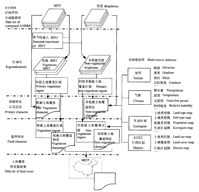
图2 建立NECT土地覆盖特征数据集的流程图 (Loveland et al. 1991, 修改)
Fig.2 Processing flow for developing the land cover characteristics data set in NECT (Modified from Loveland et al. 1991)
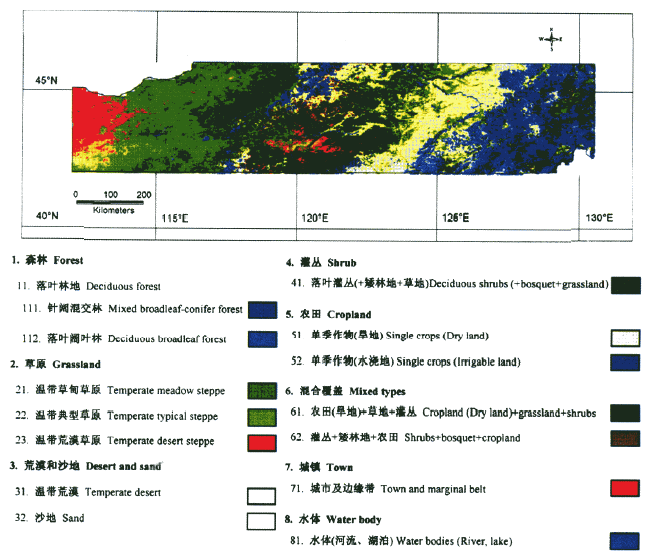
图3 中国东北陆地生态系统样带土地覆盖图
Fig.3 Land cover map of NECT
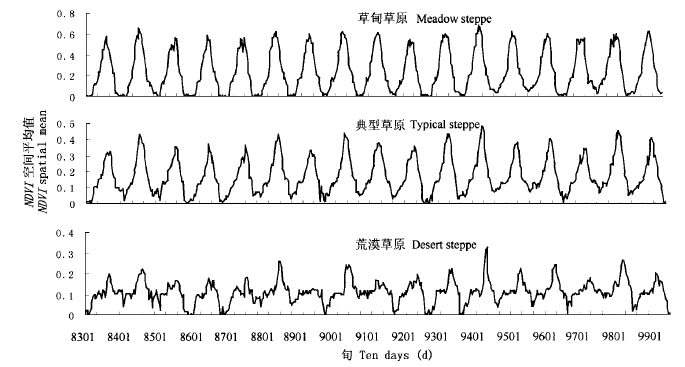
图4 1983~1992年逐旬NDVI变化
Fig.4 Seasonal NDVI rhythm (ten-day) from 1983 to 1999
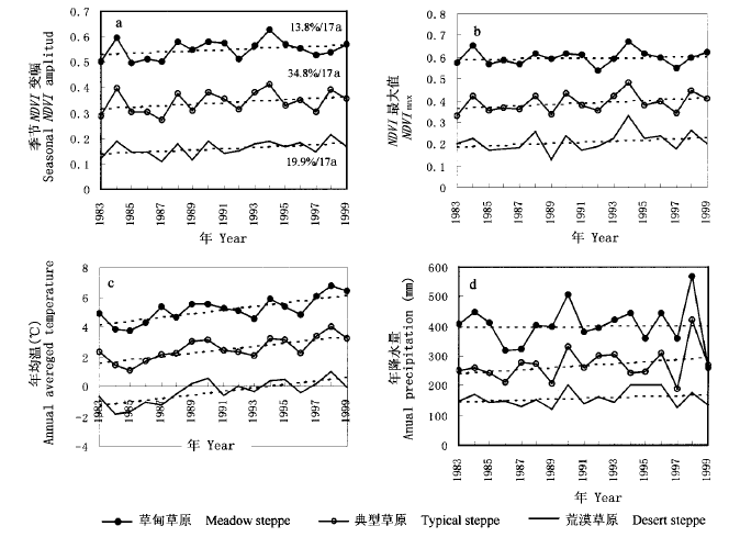
图5 1983~1992年季节NDVI变幅 (a), NDVImax (b), 年均温 (c) 和年降水量 (d) 动态 图中虚线代表变化趋势线
Fig.5 Seasonal NDVI amplitude (a), annual NDVImax (b), annual averaged temperature (c) and annual precipitation variation (d) from 1983 to 1999 Broken lines present trend in the figure
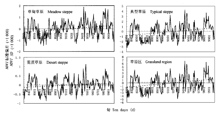
图6 NDVI标准偏差的时间变化特征
Fig.6 Time series of spatial sums of 10-day NDVI standard deviation
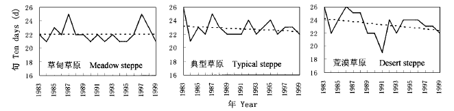
图7 1983~1999年NDVImax出现的时间变化曲线
Fig.7 Change of NDVImax outset timing from 1983 to 1999
| [1] |
Cihlar J (2000). Land cover mapping of large areas from satellites: status and research priorities. International Journal of Remote Sensing, 21,1093-1114.
DOI URL |
| [2] |
Cihlar J, St-Laurent L, Dyer JA (1991). Relationship between the Normalized Difference Vegetation Index (NDVI) and ecological variables. Remote Sensing of Environment, 35,279-298.
DOI URL |
| [3] |
DeFries KL, Townshend JRG (1994). NDVI-derived land cover classification at global scales. International Journal of Remote Sensing, 15,3567-3586.
DOI URL |
| [4] |
DeFries RS, Hansen MC, Townshend JRG, Sohlberg RS (1998). Global land cover classification at 8 km spatial resolution: the use of training data derived from Landsat imagery in decision tree classifiers. International Journal of Remote Sensing, 19,3141-3168.
DOI URL |
| [5] | Eastman JR, Fulk M (1993). Long time series evaluation using standardized principal components. Photogrammetric Engineering and Remote Sensing, 59,991-996. |
| [6] |
Eidenshink JC, Faundeen JL (1986). The 1-km AVHRR global land data set: first stages in implementation. International Journal of Remote Sensing, 7,1417-1434.
DOI URL |
| [7] |
Eklundh L (1998). Estimating relations between AVHRR NDVI and rainfall in East Africa at 10-day and monthly time scale. International Journal of Remote Sensing, 19,563-568.
DOI URL |
| [8] |
Fennessy MJ, Xue Y (1997). Impact on USGS vegetation map on GCM simulations over the United States. Ecological Applications, 7,22-23.
DOI URL |
| [9] | Fung T, LaDrew E (1987). Application of principal components analysis to change detection. Photogrammetric Engineering and Remote Sensing, 53,1649-1658. |
| [10] |
Hansen MC, Reed B (2000). A comparison of the IGBP DISCover and University of Maryland 1 km global land cover products. International Journal of Remote Sensing, 21,1365-1373.
DOI URL |
| [11] | Henderson-Sellers A, Wilson MF, Thomas G, Dickinson RE (1986). Current Global Land-Surface Data Sets for Use in Climate-Related Studies: NCAR Technical Note+STR. Boulder, Colorado, 110. |
| [12] |
Holben BN (1986). Characteristic of maximum-value composite images from temporal AVHRR data. International Journal of Remote Sensing, 15,3443-3462.
DOI URL |
| [13] | IGBP (1990). Global Change, Report No.12. Stockholm, Sweden. |
| [14] |
James ME, Kalluri SNV (1994). The Pathfinder AVHRR land data set: an improved coarse resolution data set for terrestrial monitoring. International Journal of Remote Sensing, 15,3347-3363.
DOI URL |
| [15] |
Keeling CD, Whorf TP, Whalen M, van der Plicht J (1995). Interannual extremes in the rise of atmospheric carbon dioxide since 1980. Nature, 375,666-667.
DOI URL |
| [16] |
Lambin EF, Ehrlich D (1997). Land-cover changes in Sub-Saharan Africa (1982-1991): application of a change index based on remotely sensed surface temperature and vegetation indices at a continental scale. Remote Sensing of Environment, 61,181-200.
DOI URL |
| [17] |
Lark RM (1995). Contribution of principal components to discrimination of classes of land cover in multi-spectral imagery. International Journal of Remote Sensing, 16,779-787.
DOI URL |
| [18] | Li XB (李晓兵) (1997). Application of NOAA-AVHRR data on study of land cover change. Earth Science Frontiers (地学前缘), 4 (1-2), 16. (in Chinese with English abstract) |
| [19] |
Li XB (李晓兵), Chen YH (陈云浩), Li X (李霞) (2003). Study on regional land cover patterns derived from multi-scale remotely sensed data. Acta Phytoecologica Sinica (植物生态学报), 27,577-586. (in Chinese with English abstract)
DOI |
| [20] | Li XB (李晓兵), Shi PJ (史培军) (1999). Research on regulation of NDVI change of Chinese primary vegetation types based on NOAA/AVHRR data. Acta Botanica Sinica (植物学报), 41,314-324. (in Chinese with English abstract) |
| [21] |
Lloyd D (1991). A phonological classification of terrestrial vegetation using shortwave vegetation index imagery. International Journal of Remote Sensing, 11,2269-2279.
DOI URL |
| [22] |
Loveland TR, Belward AS (1997). The IGBP-DIS global 1 km land cover dataset, DISCover: first results. International Journal of Remote Sensing, 18,3289-3295.
DOI URL |
| [23] | Loveland TR, Merchant JW, Brown JF, Ohlen DO, Reed BC, Olson P, Hutchinson J (1995). Seasonal land-cover regions of the United States. Annals of Association of American Geographer, 82,339-355. |
| [24] | Loveland TR, Merchant JW, Ohlen DO, Brown JF (1991). Development of a land-cover characteristics database for the conterminous U. S. Photogrammetric Engineering and Remote Sensing, 57,1453-1463. |
| [25] |
Loveland TR, Reed BC, Brown JF, Ohlen DO, Zhu Z, Yang L, Merchant JW (2000). Development of a global land cover characteristics database and IGBP DISCover from 1km AVHRR data. International Journal of Remote Sensing, 21,1303-1330.
DOI URL |
| [26] | Mynenl RB, Keeling CD, Tucker CJ, Asrar G Nemani, RR (1997). Increased plant growth in the northern high latitudes from 1981 to 1991. Nature, 386,698-702. |
| [27] |
Pan YZ, Li XB, Gong P, He CY, Shi PJ, Pu RL (2003). An integrative classification of vegetation in China based on NOAA/AVHRR and vegetation-climate indices of the holdridge life zone. International Journal of Remote Sensing, 24,1009-1027.
DOI URL |
| [28] |
Reed BC, Brown JF, VanderZee D, Loveland TR, Merchant JW, Ohlen DO (1994). Measuring phenological variability from satellite imagery. Journal of Vegetation Science, 5,703-714.
DOI URL |
| [29] |
Running SW, Loveland TR (1995). A remote sensing based vegetation classification logic for global land cover analysis. Remote Sensing of Environment, 51,39-48.
DOI URL |
| [30] |
Townshend JRG (1994). Global data sets for land applications from the Advance Very High Resolution Radiometer: an introduction. International Journal of Remote Sensing, 15,3319-3332.
DOI URL |
| [31] |
Townshend JRG, Justice CO, Kalb V (1987). Characterization and classification of South American land cover types using satellite data. International Journal of Remote Sensing, 7,1395-1416.
DOI URL |
| [32] |
Turker CJ, Townshend JRG, Goff TE (1985). African land-cover classification using satellite data. Science, 227,369-375.
DOI URL |
| [33] | Zhang XS (张新时) (1989). The potential evapotranspiration (PE) index for vegetation and vegetation-climatic classification (Ⅱ) — an introduction of main methods and PEP program. Acta Phytoecologica Sinica (植物生态学报), 13,197-207. (in Chinese with English abstract) |
| [34] | Zhang XS (张新时), Gao Q (高琼), Yang DA (杨奠安), Zhou GS (周广胜), Ni J (倪健), Wang Q (王权) (1997). A gradient analysis and prediction on the northeast China transect (NECT) for global change study. Acta Botanica Sinica (植物学报), 39,785-799. (in Chinese with English abstract) |
| [35] | Zhou GS (周广胜) (2002). NECT and Global Change (NECT与全球变化). Meteorological Press, Beijing. (in Chinese) |
| [1] | 张智洋 赵颖慧 甄贞. 1986-2022年松花江流域陆地生态系统碳储量动态监测[J]. 植物生态学报, 2024, 48(预发表): 0-0. |
| [2] | 白娥, 薛冰. 土地利用与土地覆盖变化对生态系统的影响[J]. 植物生态学报, 2020, 44(5): 543-552. |
| [3] | 张峰, 周广胜. 中国东北样带植被净初级生产力时空动态遥感模拟[J]. 植物生态学报, 2008, 32(4): 798-809. |
| [4] | 周睿, 胡玉喆, 熊颖, 王辉, 葛剑平, 毕晓丽. 岷江上游河岸带土地覆盖格局及其生态学解释[J]. 植物生态学报, 2007, 31(1): 2-10. |
| [5] | 喻锋, 李晓兵, 王宏, 余弘婧, 陈云浩. 基于NDVI-Ts特征空间的中国土地覆盖分类研究[J]. 植物生态学报, 2005, 29(6): 934-944. |
| [6] | 李晓兵, 陈云浩, 李霞. 测量的区域土地覆盖格局研基于多尺度遥感究[J]. 植物生态学报, 2003, 27(5): 577-586. |
| [7] | 杨健, 池宏康, 莫沫. 应用神经网络和多谱段遥感数据对大屿山岛土地覆盖分类的研究[J]. 植物生态学报, 2002, 26(2): 185-188. |
| 阅读次数 | ||||||
|
全文 |
|
|||||
|
摘要 |
|
|||||
Copyright © 2022 版权所有 《植物生态学报》编辑部
地址: 北京香山南辛村20号, 邮编: 100093
Tel.: 010-62836134, 62836138; Fax: 010-82599431; E-mail: apes@ibcas.ac.cn, cjpe@ibcas.ac.cn
备案号: 京ICP备16067583号-19