
植物生态学报 ›› 2007, Vol. 31 ›› Issue (1): 2-10.DOI: 10.17521/cjpe.2007.0002
周睿1,2, 胡玉喆1, 熊颖1, 王辉1, 葛剑平1,*( ), 毕晓丽3
收稿日期:2006-01-12
接受日期:2006-05-14
出版日期:2007-01-12
发布日期:2007-01-30
通讯作者:
葛剑平
作者简介:* E-mail: gejp@bnu.edu.cn基金资助:
ZHOU Rui1,2, HU Yu-Zhe1, XIONG Ying1, WANG Hui1, GE Jian-Ping1,*(), BI Xiao-Li3
Received:2006-01-12
Accepted:2006-05-14
Online:2007-01-12
Published:2007-01-30
Contact:
GE Jian-Ping
摘要:
针对岷江上游干流河岸带的土地覆盖状况,将该区沿河流主干分为68个样方,结合空间信息及环境因子,对这些样方及流域内的12种土地覆盖类型,采用双向指示种分析法(Two-way indicator species analysis, TWINSPAN)和除趋势典范对应分析法(Detrended canonical correspondence analysis, DCCA)对种类和样方进行分类和排序,以揭示其生态学意义及环境影响因素。结果显示:1)研究区土地覆盖可分为高植被覆盖、中度植被覆盖和低/非植被覆盖3种类别,各类别在流域不同位置分布状况不同,整个流域以中度植被覆盖为主。2)所取样方可分为8个类群,各自拥有相似的土地覆盖组成,呈聚集分布。3)根据土地覆盖特征,河岸带可分为上、中、下3段,流域上段河岸带植被覆盖度较高;中段以中度植被覆盖类型为主,占总面积最大;下段集中了大部分人工土地覆盖类型。4)气温、海拔是影响岷江上游干流河岸带土地覆盖格局的最重要因素,此外降水和人类活动对其也有影响。除干旱河谷区外,顺流自上而下,海拔逐渐降低,水热条件逐渐改善,同时人类干扰强度也逐渐增加,是造成流域3段截然不同的土地覆盖格局的原因。5)干旱河谷特殊的土地覆盖格局是水、热共同作用造成的。总之,岷江上游河岸带土地覆盖呈现出一定的梯度变化特征,自然条件的制约是形成这一格局的主要原因。
周睿, 胡玉喆, 熊颖, 王辉, 葛剑平, 毕晓丽. 岷江上游河岸带土地覆盖格局及其生态学解释. 植物生态学报, 2007, 31(1): 2-10. DOI: 10.17521/cjpe.2007.0002
ZHOU Rui, HU Yu-Zhe, XIONG Ying, WANG Hui, GE Jian-Ping, BI Xiao-Li. INTERPRETING ECOLOGICAL LAND COVER PATTERN FOR THE RIPARIAN ZONE OF THE UPPER MINJIANG RIVER, CHINA. Chinese Journal of Plant Ecology, 2007, 31(1): 2-10. DOI: 10.17521/cjpe.2007.0002
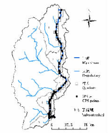
图1 样方设置及野外调查点
Fig.1 The quadrats and the GPS points
| 编码 Code | 类型 Class name | 比例(%) Percentage | ||||
|---|---|---|---|---|---|---|
| 11 | 水田 Paddy field | 0.47 | ||||
| 12 | 旱地 Dry land | 7.40 | ||||
| 21 | 有林地 Woodland | 9.84 | ||||
| 22 | 灌木林地 Shrub | 35.19 | ||||
| 23 | 其它林地 Other woodland | 3.98 | ||||
| 24 | 园地 Orchard | 0.09 | ||||
| 31 | 高覆盖度草地 High cover grassland | 10.98 | ||||
| 32 | 中覆盖度草地 Moderate cover grassland | 31.46 | ||||
| 41 | 河渠 River | 0.10 | ||||
| 42 | 湖泊 Lake | 0.12 | ||||
| 51 | 城镇用地 Town | 0.14 | ||||
| 52 | 工矿用地 Factory | 0.22 | ||||
表1 土地覆盖类型编码
Table 1 The code of land cover
| 编码 Code | 类型 Class name | 比例(%) Percentage | ||||
|---|---|---|---|---|---|---|
| 11 | 水田 Paddy field | 0.47 | ||||
| 12 | 旱地 Dry land | 7.40 | ||||
| 21 | 有林地 Woodland | 9.84 | ||||
| 22 | 灌木林地 Shrub | 35.19 | ||||
| 23 | 其它林地 Other woodland | 3.98 | ||||
| 24 | 园地 Orchard | 0.09 | ||||
| 31 | 高覆盖度草地 High cover grassland | 10.98 | ||||
| 32 | 中覆盖度草地 Moderate cover grassland | 31.46 | ||||
| 41 | 河渠 River | 0.10 | ||||
| 42 | 湖泊 Lake | 0.12 | ||||
| 51 | 城镇用地 Town | 0.14 | ||||
| 52 | 工矿用地 Factory | 0.22 | ||||
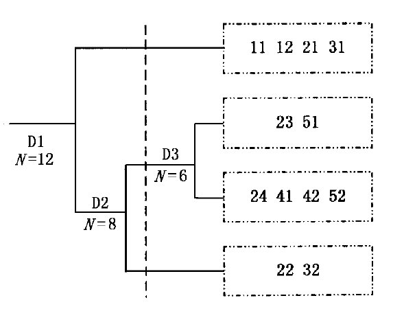
图2 12种土地覆盖类型的TWINSPAN分类树状图 D1、D2、D3:1、2、3级分割 Division 1, 2 and 3
Fig.2 Dendrogram of the TWINSPAN classification of 12 classes of land cover
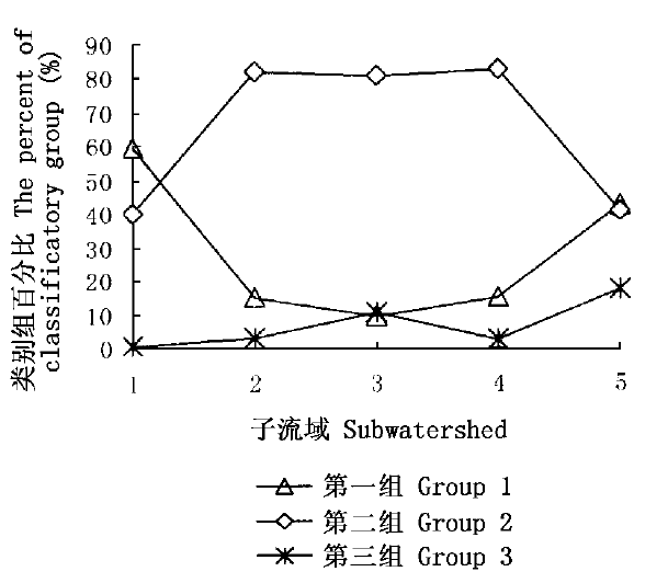
图3 各子流域中类型组分布比例
Fig.3 The distribution of the classificatory group in subwatersheds
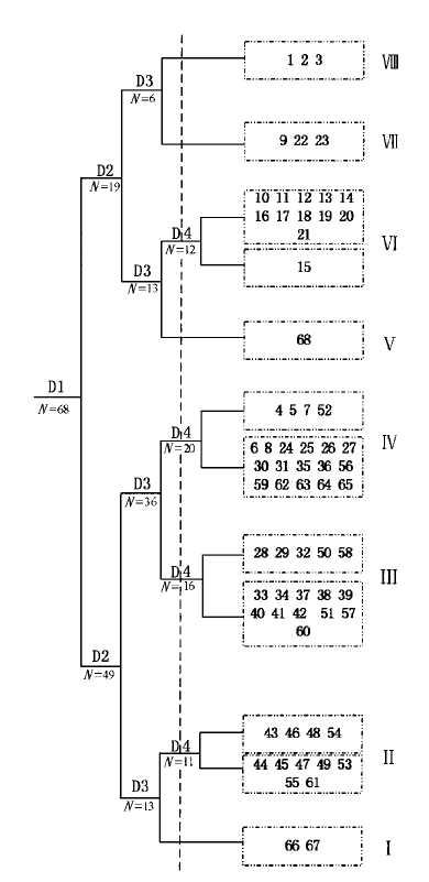
图4 68个样方的TWINSPAN分类树状图 D1、D2、D3、D4:1、2、3、4级分割 Division 1, 2, 3 and 4
Fig.4 Dendrogram of the TWINSPAN classification of 68 quadrats
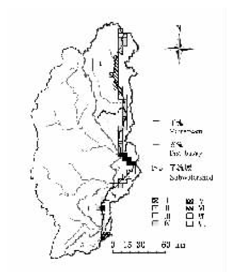
图5 TWINSPAN类型地理分布 Ⅰ~Ⅷ: 8类样方群 Eight quadrats types
Fig.5 The geographic distribution of the TWINSPAN types
| 类群 Type | 子流域 Sub- watershed | 土地覆盖组成 Land cover | 环境因子 Environmental factors | |||||
|---|---|---|---|---|---|---|---|---|
| 第一组比例 Percentage of group 1 (%) | 第二组比例 Percentage of group 2 (%) | 第三组比例 Percentage of group 3 (%) | 海拔高度 Elevation (m) | 年降水量 Annual precipitation (mm) | 年均温 Average annual temperature (℃) | 居民点密度 Density of residence (km-2) | ||
| Ⅷ | 1 | 35.10 | 64.88 | 0.02 | 3 892.33 | 386.66 | 3.24 | 0.02 |
| Ⅵ | 1 | 78.13 | 21.27 | 0.60 | 3 169.08 | 656.67 | 5.84 | 0.09 |
| Ⅶ | 1 | 48.75 | 51.25 | 0 | 3 574.33 | 686.52 | 5.64 | 0.09 |
| Ⅲ | 2、3、4 | 3.93 | 95.36 | 0.81 | 2 412.19 | 650.63 | 10.74 | 0.12 |
| Ⅱ | 3、4 | 8.65 | 75.19 | 16.16 | 1 856.46 | 793.49 | 11.67 | 0.13 |
| Ⅳ | 1、2、3、4 | 24.58 | 72.11 | 3.31 | 2 536.40 | 721.82 | 8.64 | 0.15 |
| Ⅴ | 5 | 50.89 | 42.02 | 7.09 | 1 615.00 | 1 161.23 | 15.59 | 0.15 |
| Ⅰ | 5 | 35.33 | 42.37 | 22.30 | 1 061.00 | 1 122.02 | 15.30 | 0.21 |
表2 样方类型及特征
Table 2 Quadrats classification and characteristic
| 类群 Type | 子流域 Sub- watershed | 土地覆盖组成 Land cover | 环境因子 Environmental factors | |||||
|---|---|---|---|---|---|---|---|---|
| 第一组比例 Percentage of group 1 (%) | 第二组比例 Percentage of group 2 (%) | 第三组比例 Percentage of group 3 (%) | 海拔高度 Elevation (m) | 年降水量 Annual precipitation (mm) | 年均温 Average annual temperature (℃) | 居民点密度 Density of residence (km-2) | ||
| Ⅷ | 1 | 35.10 | 64.88 | 0.02 | 3 892.33 | 386.66 | 3.24 | 0.02 |
| Ⅵ | 1 | 78.13 | 21.27 | 0.60 | 3 169.08 | 656.67 | 5.84 | 0.09 |
| Ⅶ | 1 | 48.75 | 51.25 | 0 | 3 574.33 | 686.52 | 5.64 | 0.09 |
| Ⅲ | 2、3、4 | 3.93 | 95.36 | 0.81 | 2 412.19 | 650.63 | 10.74 | 0.12 |
| Ⅱ | 3、4 | 8.65 | 75.19 | 16.16 | 1 856.46 | 793.49 | 11.67 | 0.13 |
| Ⅳ | 1、2、3、4 | 24.58 | 72.11 | 3.31 | 2 536.40 | 721.82 | 8.64 | 0.15 |
| Ⅴ | 5 | 50.89 | 42.02 | 7.09 | 1 615.00 | 1 161.23 | 15.59 | 0.15 |
| Ⅰ | 5 | 35.33 | 42.37 | 22.30 | 1 061.00 | 1 122.02 | 15.30 | 0.21 |
| 轴1 Axis 1 | 轴2 Axis 2 | 轴3 Axis 3 | ||
|---|---|---|---|---|
| 环境因子-排序轴相关系数 Correlations of environmental variables with the first three axes of DCCA | 海拔高度DEM | 0.680 | 0.206 | 0.285 |
| 年均温TEM | -0.830 | -0.086 | -0.451 | |
| 年降水RAIN | -0.326 | -0.708 | -0.034 | |
| 居民点密度RES | 0.171 | -0.632 | -0.276 | |
| 坡度SLOP | -0.428 | 0.013 | -0.793 | |
| 土地覆盖类型-环境相关系数 Landcover-environment correlation coefficients | 0.762 | 0.575 | 0.451 | |
| 特征值 Eigenvalues | 0.258 | 0.074 | 0.023 | |
| 累计解释量 Cumulative percentage variance of landcover-environment relation | 60.879 | 81.702 | 81.702 | |
表3 DCCA排序统计表
Table 3 Statistic for the first three axes of DCCA
| 轴1 Axis 1 | 轴2 Axis 2 | 轴3 Axis 3 | ||
|---|---|---|---|---|
| 环境因子-排序轴相关系数 Correlations of environmental variables with the first three axes of DCCA | 海拔高度DEM | 0.680 | 0.206 | 0.285 |
| 年均温TEM | -0.830 | -0.086 | -0.451 | |
| 年降水RAIN | -0.326 | -0.708 | -0.034 | |
| 居民点密度RES | 0.171 | -0.632 | -0.276 | |
| 坡度SLOP | -0.428 | 0.013 | -0.793 | |
| 土地覆盖类型-环境相关系数 Landcover-environment correlation coefficients | 0.762 | 0.575 | 0.451 | |
| 特征值 Eigenvalues | 0.258 | 0.074 | 0.023 | |
| 累计解释量 Cumulative percentage variance of landcover-environment relation | 60.879 | 81.702 | 81.702 | |
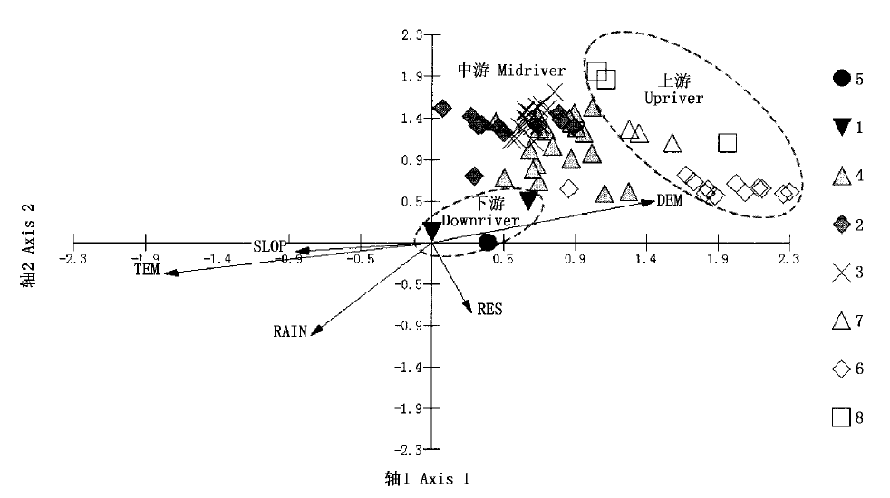
图6 68个样方的DCCA二维排序图 DEM、TEM、RAIN、RES、SLOP:见表3 See Table 3 1~8: 类型1~8 Type 1-8
Fig.6 Two-dimensional DCCA ordination diagram of 68 quadrats
| [1] | Aguiar FC, Ferreira MT (2005). Human-disturbed landscapes: effects on composition and integrity of riparian woody vegetation in the Tagus River basin, Portugal. Environmental Conservation, 32,30-41. |
| [2] | Chen JQ (陈吉泉) (1996). Riparian vegetation characteristics and their functions in ecosystems and landscapes. Chinese Journal of Applied Ecology (应用生态学报), 7,439-448. |
| [3] | Corbacho C, Sanchez JM, Costillo E (2003). Patterns of structural complexity and human disturbance of riparian vegetation in agricultural landscapes of a Mediterranean area. Agriculture Ecosystems & Environment, 95,495-507. |
| [4] | Deng HB (邓红兵), Wang QL(王庆礼), Cai QH (蔡庆华) (1998). Watershed ecology—new discipline, new idea and new approach. Chinese Journal of Applied Ecology (应用生态学报), 9,443-449. (in Chinese with English abstract) |
| [5] | Elderd BD (2003). The impact of changing flow regimes on riparian vegetation and the riparian species Mimulus guttatus. Ecological Applications, 13,1610-1625. |
| [6] | Fleishman E, Mcdonal N, Mac Nally R, Murphy DD, Walters J, Floyd T (2003). Effects of floristics, physiognomy and non-native vegetation on riparian bird communities in a Mojave Desert watershed. Journal of Animal Ecology, 72,484-490. |
| [7] | Guo JH (郭敬辉), Wang YZ (王玉枝), Li XY (李秀云) (1985). Hydrography at West of Sichuan and North of Yunnan (川西滇北地区水文地理). Science Press, Beijing. (in Chinese) |
| [8] | Heartsill-Scalley T, Aide TM (2003). Riparian vegetation and stream condition in a tropical agriculture-secondary forest mosaic. Ecological Applications, 13,225-234. |
| [9] | Hill MO (1979). TWINSPAN-a FORTRAN Program for Arranging Multivariate Data in an Ordered Two-Way Table by Classification of the Individuals and Attributes. Cornell University, Ithaca, NY. |
| [10] | Lamb EG, Mallik AU, Mackereth RW (2003). The early impact of adjacent clearcutting and forest fire on riparian zone vegetation in northwestern Ontario. Forest Ecology and Management, 177,529-538. |
| [11] | Li AN (李爱农), Zhou WC (周万村), Li FB (李发斌), Ma ZZ (马泽忠) (2005). An analysis on spatial distribution pattern of land use in upper reaches of Minjiang River based on spatial technology. Journal of Arid Land Resources and Environment (干旱区资源与环境), 19(6),53-57. (in Chinese with English abstract) |
| [12] | Li CW (李崇巍), Liu SR (刘世荣), Sun PS (孙鹏森), Ge JP (葛剑平) (2005). Analysis on landscape pattern and eco-hydrological characteristics at the upstream of Minjiang River. Acta Ecologica Sinica (生态学报), 25,691-698. (in Chinese with English abstract) |
| [13] | Liu LJ (刘丽娟) (2004). Study on Vegetation Pattern, Vegetation Dynamics and Its Influence on Hydrological Process in the Upper Minjiang River (岷江上游植被格局、动态及其生态水文功能研究). PhD dissertation, College of Life Science, Beijing Normal University, Beijing, 45-55. (in Chinese with English abstract) |
| [14] | Liu LJ (刘丽娟), Zan GS (昝国盛), Ge JP (葛剑平), Bi XL(毕晓丽), Zhou R(周睿) (2005). Application of MTCLIM in climate modeling for the up-reaches of Minjiang River. Resources and Environment in the Yangze Basin (长江流域资源与环境), 14,248-253. (in Chinese with English abstract) |
| [15] | Lyon J, Sagers CL (2003). Correspondence analysis of functional groups in a riparian landscape. Plant Ecology, 164,171-183. |
| [16] | Malanson GP (1993). Riparian Landscape. Cambridge University Press, Cambridge. |
| [17] | Medina-Vogel G, Kaufman VS, Monsalve R, Gomez V (2003). The influence of riparian vegetation, woody debris, stream morphology and human activity on the use of rivers by southern river otters in Lontra provocax in Chile. Oryx, 37,422-430. |
| [18] | Naiman RJ, Decamps H (1997). The ecology of interfaces: riparian zones. Annual Review of Ecology and Systematics, 28,621-658. |
| [19] | Oksanen J, Minchin PR (1997). Instability of ordination results under changes in input data order: explanations and remedies. Journal of Vegetation Science, 8,447-454. |
| [20] | Schwabe A (1989). Vegetation complexes of flowing water habitats and their importance for the differentiation of landscape units. Landscape Ecology, 2,237-253. |
| [21] | Song YC (宋永昌) (2001). Vegetation Ecology (植被生态学). East China Normal University Press, Shanghai. (in Chinese) |
| [22] | Tabacchi E, Planty-Tabacchi AM (2003). Recent changes in riparian vegetation: possible consequences on dead wood processing along rivers. River Research and Applications, 19,251-263. |
| [23] | Vannote RL, Minshall GW, Cummins KW (1980). The river continuum concept. Canadian Journal of Fisheries and Aquatic Sciences, 37,130-137. |
| [24] | Wu Y (吴勇), Su ZX (苏智先), Fang JY (方精云) (2003). Study on causes and ecological renewal of arid and warm valley of upper Minjiang River. Journal of China West Normal University (Natural Science) (西华师范大学学报(自然科学版)), 24,276-281. (in Chinese with English abstract) |
| [25] | Yeakley JA, Coleman DC, Haines BL, Kloeppel BD, Meyer JL, Swank WT, Argo BW, Deal JM, Taylor SF (2003). Hillslope nutrient dynamics following upland riparian vegetation disturbance. Ecosystems, 6,154-167. |
| [26] | Zhang F (张峰), Zhang JT (张金屯) (2000). Research progress of numerical classification and ordination of vegetation in China. Journal of Shanxi University (Natural Science Edition) (山西大学学报(自然科学版)), 23,278-282. (in Chinese with English abstract) |
| [27] | Zhang JT (张金屯) (2004). Quantitative Ecology (数量生态学), Science Press, Beijing. (in Chinese) |
| [28] | Zhang RZ (张荣祖) (1992). The Arid Valleys of the Hengduan Mountains Region (横断山区干旱河谷). Science Press, Beijing. (in Chinese) |
| [29] | Zhao YH, He XY, Hu YM, Chang Y (2005). Landscape pattern change in the upper valley of Min River. Journal of Forestry Research, 16,31-34. |
| [1] | 张智洋 赵颖慧 甄贞. 1986-2022年松花江流域陆地生态系统碳储量动态监测[J]. 植物生态学报, 2024, 48(预发表): 0-0. |
| [2] | 蔚亮, 李均力, 包安明, 白洁, 黄粤, 刘铁, 沈占锋. 塔里木河下游湿地面积时序变化及对生态输水的响应[J]. 植物生态学报, 2020, 44(6): 616-627. |
| [3] | 白娥, 薛冰. 土地利用与土地覆盖变化对生态系统的影响[J]. 植物生态学报, 2020, 44(5): 543-552. |
| [4] | 梁士楚, 刘润红, 荣春艳, 常斌, 姜勇. 漓江河岸带植物功能性状变异与关联[J]. 植物生态学报, 2019, 43(1): 16-26. |
| [5] | 陈怡超, 赵莹, 宋希强, 任明迅. 海南杜鹃在河岸带弯道两侧的空间分布格局和年龄结构差异[J]. 植物生态学报, 2018, 42(8): 841-849. |
| [6] | 李亚飞, 于静洁, 陆凯, 王平, 张一驰, 杜朝阳. 额济纳三角洲胡杨和多枝柽柳水分来源解析[J]. 植物生态学报, 2017, 41(5): 519-528. |
| [7] | 岳楷, 杨万勤, 彭艳, 黄春萍, 张川, 吴福忠. 高寒森林溪流对凋落叶分解过程中木质素降解的影响[J]. 植物生态学报, 2016, 40(9): 893-901. |
| [8] | 朱绪超, 袁国富, 邵明安, 易小波, 杜涛. 塔里木河下游河岸带植被的空间结构特征[J]. 植物生态学报, 2015, 39(11): 1053-1061. |
| [9] | 王谢,向成华,李贤伟,文冬菊. 冬季火对川西亚高山草地植物群落结构和牧草质量的影响[J]. 植物生态学报, 2013, 37(10): 922-932. |
| [10] | 李海东, 沈渭寿, 方颖, 燕守广, 张慧, 赵卫. 雅鲁藏布江中游河岸带几种主要沙生植物种群点格局分析[J]. 植物生态学报, 2011, 35(8): 834-843. |
| [11] | 何东, 魏新增, 李连发, 江明喜, 杨敬元, 喻杰. 神农架山地河岸带连香树的种群结构与动态[J]. 植物生态学报, 2009, 33(3): 469-481. |
| [12] | 魏新增, 黄汉东, 江明喜, 杨敬元. 神农架地区河岸带中领春木种群数量特征与空间分布格局[J]. 植物生态学报, 2008, 32(4): 825-837. |
| [13] | 冯云, 马克明, 张育新, 祁建. 辽东栎林不同层植物沿海拔梯度分布的DCCA分析[J]. 植物生态学报, 2008, 32(3): 568-573. |
| [14] | 刘秋锋, 康慕谊, 刘全儒. 中条山混沟地区森林乔木种的数量分类与环境解释[J]. 植物生态学报, 2006, 30(3): 383-391. |
| [15] | 喻锋, 李晓兵, 王宏, 余弘婧, 陈云浩. 基于NDVI-Ts特征空间的中国土地覆盖分类研究[J]. 植物生态学报, 2005, 29(6): 934-944. |
| 阅读次数 | ||||||
|
全文 |
|
|||||
|
摘要 |
|
|||||
Copyright © 2022 版权所有 《植物生态学报》编辑部
地址: 北京香山南辛村20号, 邮编: 100093
Tel.: 010-62836134, 62836138; Fax: 010-82599431; E-mail: apes@ibcas.ac.cn, cjpe@ibcas.ac.cn
备案号: 京ICP备16067583号-19