
植物生态学报 ›› 2006, Vol. 30 ›› Issue (3): 383-391.DOI: 10.17521/cjpe.2006.0052
刘秋锋1,2, 康慕谊2,4, 刘全儒3,4
接受日期:2005-09-19
发布日期:2006-05-30
基金资助:LIU Qiu-Feng1,2, KANG Mu-Yi2,4, LIU Quan-Ru3,4
Accepted:2005-09-19
Published:2006-05-30
摘要:
通过对中条山混沟地区森林植被调查资料的多元分析——TWINSPAN分类、CCA排序与环境解释,划分了该地区的植被类型,给出了植被与环境因子的定量关系。结果如下:1)40个样地可划分为青檀林(Form.Pteroceltis tatarinowii)、栾树林(Form. Koelreuteria paniculata)、槲栎林(Form. Quercus aliena)、栓皮栎林(Form. Quercus variabilis)、鹅耳枥+葛萝槭林(Form. Carpinus turczaninowii+Acer grosseri)、元宝槭+千金榆林(Form. Acer truncatum+Carpinus cordata)和辽东栎林(Form. Quercus liaotungensis)7种群落类型,体现了中条山地带性植被类型为暖温带落叶阔叶林的特点。2)群落类型的划分主要反映了CCA排序第一、二轴的环境梯度,CCA排序第一轴突出反映了海拔与土壤养分梯度,第二轴与土壤pH值、湿度指数和坡度显著相关。总体来说,海拔和土壤因子是影响混沟地区乔木物种分布分异的最主要环境因子。3)环境因子和空间因子解释了物种格局变化的46.14%,其中环境因子占30.79%,空间因子占8.48%,空间因子和环境因子交互作用解释的部分占6.87%。良好的环境解释反映了调查取样和环境因子选取的合理性,同时也体现了混沟地区植被的原始性。
刘秋锋, 康慕谊, 刘全儒. 中条山混沟地区森林乔木种的数量分类与环境解释. 植物生态学报, 2006, 30(3): 383-391. DOI: 10.17521/cjpe.2006.0052
LIU Qiu-Feng, KANG Mu-Yi, LIU Quan-Ru. QUANTITATIVE CLASSIFICATION AND ENVIRONMENTAL INTERPRETATION OF FOREST TREE SPECIES IN HUNGOU, ZHONGTIAO MOUNTAIN. Chinese Journal of Plant Ecology, 2006, 30(3): 383-391. DOI: 10.17521/cjpe.2006.0052
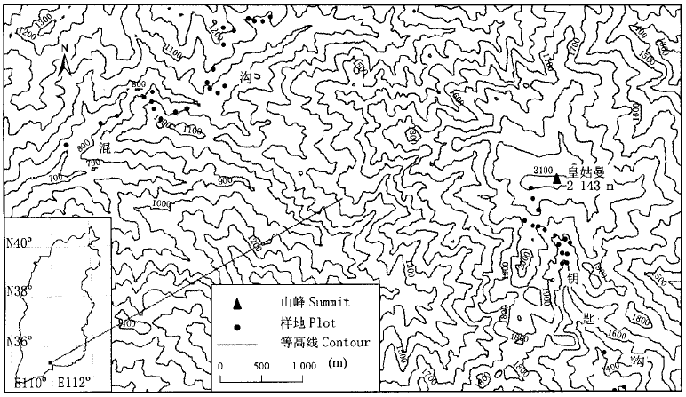
图1 研究区位置及样地设置示意图
Fig.1 Sketch map of the location of the study area and the investigated plots
| 科 Family | 种数 No. of species | 比例 % of all species | 属 Genus | 种数 No. of species | 比例 % of all species | ||||||||||||||||
|---|---|---|---|---|---|---|---|---|---|---|---|---|---|---|---|---|---|---|---|---|---|
| 1. 蔷薇科Rosaceae 2. 菊科Compositae 3. 百合科Liliaceae 4. 豆科Leguminosae 5. 虎耳草科Saxifragaceae 6. 忍冬科Caprifoliaceae 7. 毛茛科Ranunculaceae 8. 禾本科Gramineae 9. 唇形科Labiatae 10. 榆科Ulmaceae | 23 15 15 11 11 11 10 8 7 7 | 10.36 6.76 6.76 4.95 4.95 4.95 4.50 3.60 3.15 3.15 | 1. 茶 2. 忍冬属Lonicera 3. 蒿属Artemisia 4. 栎属Quercus 5. 槭属Acer 6. 花楸属Sorbus 7. 荚 8. 苔草属Carex 9. 卫矛属Euonymus 10. 鼠李属Rhamnus | 5 5 5 4 4 4 4 3 3 3 | 2.25 2.25 2.25 1.80 1.80 1.80 1.80 1.35 1.35 1.35 | ||||||||||||||||
| 总计Total | 118 | 53.15 | 40 | 18.02 | |||||||||||||||||
表1 混沟地区植物主要科属统计
Table 1 The main family and genus of Hungou
| 科 Family | 种数 No. of species | 比例 % of all species | 属 Genus | 种数 No. of species | 比例 % of all species | ||||||||||||||||
|---|---|---|---|---|---|---|---|---|---|---|---|---|---|---|---|---|---|---|---|---|---|
| 1. 蔷薇科Rosaceae 2. 菊科Compositae 3. 百合科Liliaceae 4. 豆科Leguminosae 5. 虎耳草科Saxifragaceae 6. 忍冬科Caprifoliaceae 7. 毛茛科Ranunculaceae 8. 禾本科Gramineae 9. 唇形科Labiatae 10. 榆科Ulmaceae | 23 15 15 11 11 11 10 8 7 7 | 10.36 6.76 6.76 4.95 4.95 4.95 4.50 3.60 3.15 3.15 | 1. 茶 2. 忍冬属Lonicera 3. 蒿属Artemisia 4. 栎属Quercus 5. 槭属Acer 6. 花楸属Sorbus 7. 荚 8. 苔草属Carex 9. 卫矛属Euonymus 10. 鼠李属Rhamnus | 5 5 5 4 4 4 4 3 3 3 | 2.25 2.25 2.25 1.80 1.80 1.80 1.80 1.35 1.35 1.35 | ||||||||||||||||
| 总计Total | 118 | 53.15 | 40 | 18.02 | |||||||||||||||||
| 生境因子 Environmental factors | 最小值 Minimun | 最大值 Maximum | 平均 Mean |
|---|---|---|---|
| 海拔Altitude (m) | 730 | 2 100 | 1 343 |
| 坡度Slope (°) | 10 | 50 | 33 |
| 坡向Transformation of aspect (TRASP) | 0.01 | 0.88 | 0.57 |
| 土深Soil depth (cm) | 3 | 37 | 13 |
| pH | 5.13 | 7.85 | 6.51 |
| 全氮Total nitrogen (%) | 0.16 | 1.37 | 0.56 |
| 有机质Organic matter (%) | 5.8 | 39.6 | 15.5 |
| 湿度指数Topographic relative moisture index (TRMI) | 13 | 50 | 26.08 |
| 年总辐射量Annual total solar radiation (MJ·m-2) | 2 280 | 6 550 | 4 710 |
表2 各群落样地生境概况
Table 2 General situation of the habitats for forest growth measured at community plots
| 生境因子 Environmental factors | 最小值 Minimun | 最大值 Maximum | 平均 Mean |
|---|---|---|---|
| 海拔Altitude (m) | 730 | 2 100 | 1 343 |
| 坡度Slope (°) | 10 | 50 | 33 |
| 坡向Transformation of aspect (TRASP) | 0.01 | 0.88 | 0.57 |
| 土深Soil depth (cm) | 3 | 37 | 13 |
| pH | 5.13 | 7.85 | 6.51 |
| 全氮Total nitrogen (%) | 0.16 | 1.37 | 0.56 |
| 有机质Organic matter (%) | 5.8 | 39.6 | 15.5 |
| 湿度指数Topographic relative moisture index (TRMI) | 13 | 50 | 26.08 |
| 年总辐射量Annual total solar radiation (MJ·m-2) | 2 280 | 6 550 | 4 710 |
| 排序轴 AX | 特征值 Eigenvalues | 累计解释量 Cumulative percen- tage varaiance of species data (%) | 海拔 Altitude (m) | 坡度 Slope (°) | 坡向 TRASP | 土深 Soil depth (cm) | pH值 | 全氮 Total nitrogen (%) | 有机质 Organic matter (%) | 湿度指数 TRMI | 年总辐射 Annual total solar radiation (MJ·m-2) |
|---|---|---|---|---|---|---|---|---|---|---|---|
| CCA1 | 0.79 | 12.3 | 0.98** | -0.21 | 0.37* | 0.34 | -0.39* | 0.59** | 0.53** | 0.02 | 0.28 |
| CCA2 | 0.50 | 20.0 | -0.13 | -0.66** | 0.05 | -0.17 | 0.72** | 0.45* | 0.29 | 0.54** | 0.03 |
| CCA3 | 0.29 | 24.5 | -0.10 | 0.06 | 0.16 | -0.42* | 0.15 | 0.09 | 0.32 | 0.00 | -0.57** |
| CCA4 | 0.24 | 28.1 | -0.03 | -0.16 | -0.18 | 0.59** | 0.20 | -0.11 | -0.03 | -0.20 | 0.33 |
表4 物种CCA排序前四轴的特征值及其与各环境因子相关系数
Table 4 The eigenvalues and cumulative percentage variance of species data for the first four axes of CCA, as well as their correlation with the environmental variables
| 排序轴 AX | 特征值 Eigenvalues | 累计解释量 Cumulative percen- tage varaiance of species data (%) | 海拔 Altitude (m) | 坡度 Slope (°) | 坡向 TRASP | 土深 Soil depth (cm) | pH值 | 全氮 Total nitrogen (%) | 有机质 Organic matter (%) | 湿度指数 TRMI | 年总辐射 Annual total solar radiation (MJ·m-2) |
|---|---|---|---|---|---|---|---|---|---|---|---|
| CCA1 | 0.79 | 12.3 | 0.98** | -0.21 | 0.37* | 0.34 | -0.39* | 0.59** | 0.53** | 0.02 | 0.28 |
| CCA2 | 0.50 | 20.0 | -0.13 | -0.66** | 0.05 | -0.17 | 0.72** | 0.45* | 0.29 | 0.54** | 0.03 |
| CCA3 | 0.29 | 24.5 | -0.10 | 0.06 | 0.16 | -0.42* | 0.15 | 0.09 | 0.32 | 0.00 | -0.57** |
| CCA4 | 0.24 | 28.1 | -0.03 | -0.16 | -0.18 | 0.59** | 0.20 | -0.11 | -0.03 | -0.20 | 0.33 |
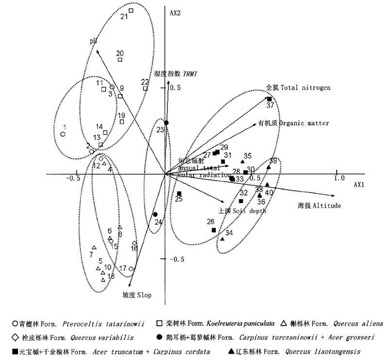
图2 样地的CCA二维排序 TRMI: 同表2 See Table 2
Fig.2 A two-dimensional scatter plot of CCA ordination for plots
| 物种矩阵对应分析总特征值Sum of eigenvalues of the species matrix | 6.45 |
|---|---|
| 环境变量约束的物种典范特征值Sum of canonical eigenvalues of the species matrix constrained by the environmental matrix | 2.43 |
| 空间变量约束的物种典范特征值Sum of canonical eigenvalues of the species matrix constrained by the spatial matrix | 0.99 |
| 去除空间变量后环境变量约束的物种典范特征值Sum of canonical eigenvalues of the species matrix constrained by the environmental matrix after removing the effect of spatial matrix | 1.99 |
| 去除环境变量后空间变量约束的物种典范特征值Sum of canonical eigenvalues of the species matrix constrained by the spatial matrix after removing the effect of environmental matrix | 0.55 |
| 植被格局环境因子解释的部分Species matrix explained by non-spatial environmental variation | 30.79% |
| 植被格局空间因子解释的部分Species matrix explained by non- environmental spatial variation | 8.48% |
| 植被格局空间因子和环境因子交互作用解释的部分Species matrix explained by the interactions between spatial and environmental variation | 6.87% |
| 空间因子和环境因子未能解释的部分Species matrix unexplained by both spatial and environmental variation | 53.86% |
表5 植被格局的环境和空间解释
Table 5 The result of environmental and spatial interpretation of forest community
| 物种矩阵对应分析总特征值Sum of eigenvalues of the species matrix | 6.45 |
|---|---|
| 环境变量约束的物种典范特征值Sum of canonical eigenvalues of the species matrix constrained by the environmental matrix | 2.43 |
| 空间变量约束的物种典范特征值Sum of canonical eigenvalues of the species matrix constrained by the spatial matrix | 0.99 |
| 去除空间变量后环境变量约束的物种典范特征值Sum of canonical eigenvalues of the species matrix constrained by the environmental matrix after removing the effect of spatial matrix | 1.99 |
| 去除环境变量后空间变量约束的物种典范特征值Sum of canonical eigenvalues of the species matrix constrained by the spatial matrix after removing the effect of environmental matrix | 0.55 |
| 植被格局环境因子解释的部分Species matrix explained by non-spatial environmental variation | 30.79% |
| 植被格局空间因子解释的部分Species matrix explained by non- environmental spatial variation | 8.48% |
| 植被格局空间因子和环境因子交互作用解释的部分Species matrix explained by the interactions between spatial and environmental variation | 6.87% |
| 空间因子和环境因子未能解释的部分Species matrix unexplained by both spatial and environmental variation | 53.86% |
| [1] | Chen LZ (陈灵芝), Chen QL (陈清朗), Liu WH (刘文华) (1997). Forest Diversity and its Geographical Distribution in China (中国森林多样性及其地理分布). Science Press, Beijing, 57. (in Chinese) |
| [2] |
Doleal J, Êrůtek M(2002). Altitudinal changes in composition and structure of mountain-temperate vegetation: a case study from the Western Carpathians. Plant Ecology, 158,201-221.
DOI URL |
| [3] | Integrated Survey Team of Loess Plateau, CAS 中国科学院黄土高原综合科学考察队) (1991). (The Vegetation Resources and its Reasonable Utilization (黄土高原地区植被资源及其合理利用). Chinese Science and Technology Press, Beijing,8-11. (in Chinese) |
| [4] | Jiang SZ (蒋世泽) (1986). The virgin forest of Hungou at the Zhongtiao Mountain. Journal of Beijing Forestry University (北京林业大学学报), 4,87-97. (in Chinese) |
| [5] | Jongman RHG, ter Braak CJF, van Tongeren OFR (1995). Data Analysis in Community and Landscape Ecology. Cambridge University Press, Cambridge,137-143. |
| [6] | Liu TW (刘天慰), Zeng ZF (曾昭玢), Sha XL (沙心苓), Meng QJ (孟清杰), Yue JY (岳建英) (1984). A preliminary report of investigation of the natural plant resource of seventy-two Hungou at the Zhongtiao MT., Shanxi Province. Wuhan Botanical Research (武汉植物学研究), 2,259-266. (in Chinese with English abstract) |
| [7] | Parker AJ (1982). The topographic relative moisture index: an approach to soil-moisture assessment in mountain terrain. Physical Geography, 3,160-168. |
| [8] | Pinder III JE, Kroh GC, White JD, May AMB (1997). The relationships between vegetation types and topography in Lassen Volcanic National Park. Plant Ecology, 131,17-29. |
| [9] | Roberts DW, Cooper SV (1989). Concepts and techniques of vegetation mapping. In Land Classifications Based on Vegetation: Applications for Resource Management. USDA Forest Service General Technical Report INT-257, Ogden,90-96. |
| [10] | Shen ZH (沈泽昊) (2002). A multi-scale study on the vegetation-environment relationship of a mountain forest transect. Acta Ecologica Sinica (生态学报), 22,461-470. (in Chinese with English abstract) |
| [11] | Shen ZH (沈泽昊), Zhang XS (张新时) (2000). The spatial pattern and topographic interpretation of the forest vegetation at Dalaoling Region in the Three Gorges. Acta Botanica Sinica (植物学报), 42,1089-1095. (in Chinese with English abstract) |
| [12] | Song YC (宋永昌) (2001). Vegetation Ecology (植被生态学). East China Normal University Press, Shanghai, 297. (in Chinese) |
| [13] | Swanson FJ, Kratz TK, Caine N (1988). Landform effects on ecosystem patterns and processes. BioScience, 38,92-98. |
| [14] | ter Braak CJF (1986). Canonical correspondence analysis: a new eigenvector method for multivariate direct gradient analysis. Ecology, 67,1167-1179. |
| [15] | Wang GH (王国宏), Yang LM (杨利民) (2001). Gradient analysis and environmental interpretation of woody plant communities in the middle section of the Northern slopes of Qilian Mountain, Gansu, China. Acta Phytoecologica Sinica (植物生态学报), 25,733-740. (in Chinese with English abstract) |
| [16] | Wu ZY (吴征镒) (1980). Vegetation of China (中国植被). Science Press, Beijing,254-262. (in Chinese) |
| [17] | Yue L (岳亮), Li SQ (李素清) (1993). The study on vegetation geographic characteristics of primitive forest in Shanxi Lishan. Journal of Shanxi Teacher's University (Natural Science Edition) (山西师范大学学报(自然科学版)), 2(Suppl.),95-101. (in Chinese with English abstract) |
| [18] | Zhang F (张峰), Zhang JT (张金屯), Zhang F (张峰) (2003). Pattern of forest vegetation and its environmental interpretation in Zhuweigou, Lishan Mountain Nature Reserve. Acta Ecologica Sinica (生态学报), 23,421-427. (in Chinese with English abstract) |
| [19] | Zhang JT (张金屯) (2004). Quantitative Ecology (数量生态学). Science Press, Beijing, 218. (in Chinese) |
| [20] | Zhang YM (张元明), Chen YN (陈亚宁), Zhang DY (张道远) (2003). Plant communities and their interrelations with environmental factors in the middle reaches of the Tarim River. Acta Geographica Sinica (地理学报), 58,109-118. (in Chinese with English abstract) |
| [21] | Zhao SQ (赵淑清), Fang JY (方精云), Zong ZJ (宗占江), Zhu B (朱彪), Shen HH (沈海花) (2004). Composition, structure and species diversity of plant communities along an altitudinal gradient on the northern slope of Mt. Changbai, Northeast China. Biodiversity Science (生物多样性), 12,164-173. (in Chinese with English abstract) |
| [22] | Zhu ZC (朱志诚) (1983). A preliminary studies on the Quercus aliena var. acuteserrata forests in the Qinling Mountain . Acta Botanica Boreali-Occidentalia Sinica (西北植物研究), 3,122-132. (in Chinese with English abstract) |
| [1] | 薛志方, 刘彤, 王立生, 宋继虎, 陈宏阳, 徐玲, 袁也. 额尔齐斯河流域主要支流平原河谷林群落结构及特征[J]. 植物生态学报, 2024, 48(3): 390-402. |
| [2] | 刘尧, 于馨, 于洋, 胡文浩, 赖江山. R程序包“rdacca.hp”在生态学数据分析中的应用: 案例与进展[J]. 植物生态学报, 2023, 47(1): 134-144. |
| [3] | 周亮, 杨君珑, 杨虎, 窦建德, 黄维, 李小伟. 宁夏蒙古扁桃群落特征与分类[J]. 植物生态学报, 2022, 46(2): 243-248. |
| [4] | 朱芩, 宁盼, 侯琳, 郝家田, 胡云云. 三江源地区刺柏属植物群落类型特征[J]. 植物生态学报, 2022, 46(1): 114-122. |
| [5] | 曹静, 苗艳明, 冯飞, 许强, 张钦弟, 毕润成. 稀有种不同处理对典范对应分析排序结果影响的比较[J]. 植物生态学报, 2015, 39(2): 167-175. |
| [6] | 黄永涛, 姚兰, 艾训儒, 吕世安, 丁易. 鄂西南两个自然保护区亚热带常绿落叶阔叶混交林类型及其常绿和落叶物种组成结构分析[J]. 植物生态学报, 2015, 39(10): 990-1002. |
| [7] | 余敏,周志勇,康峰峰,欧阳帅,米湘成,孙建新. 山西灵空山小蛇沟林下草本层植物群落梯度分析及环境解释[J]. 植物生态学报, 2013, 37(5): 373-383. |
| [8] | 王谢,向成华,李贤伟,文冬菊. 冬季火对川西亚高山草地植物群落结构和牧草质量的影响[J]. 植物生态学报, 2013, 37(10): 922-932. |
| [9] | 张春雨, 赵秀海, 赵亚洲. 长白山温带森林不同演替阶段群落结构特征[J]. 植物生态学报, 2009, 33(6): 1090-1100. |
| [10] | 冯云, 马克明, 张育新, 祁建. 辽东栎林不同层植物沿海拔梯度分布的DCCA分析[J]. 植物生态学报, 2008, 32(3): 568-573. |
| [11] | 周睿, 胡玉喆, 熊颖, 王辉, 葛剑平, 毕晓丽. 岷江上游河岸带土地覆盖格局及其生态学解释[J]. 植物生态学报, 2007, 31(1): 2-10. |
| [12] | 宋创业, 郭柯. 浑善达克沙地中部丘间低地植物群落分布与土壤环境关系[J]. 植物生态学报, 2007, 31(1): 40-49. |
| [13] | 刘琪璟, 胡理乐, 李轩然. 小流域治理20年后的千烟洲植物多样性[J]. 植物生态学报, 2005, 29(5): 766-774. |
| [14] | 张峰, 张金屯, 上官铁梁. 历山自然保护区猪尾沟森林群落植物多样性研究[J]. 植物生态学报, 2002, 26(增刊): 46-51. |
| [15] | 张峰, 张金屯, 韩广业. 历山自然保护区猪尾沟森林群落树种种间关系及环境解释[J]. 植物生态学报, 2002, 26(增刊): 52-56. |
| 阅读次数 | ||||||
|
全文 |
|
|||||
|
摘要 |
|
|||||
Copyright © 2022 版权所有 《植物生态学报》编辑部
地址: 北京香山南辛村20号, 邮编: 100093
Tel.: 010-62836134, 62836138; Fax: 010-82599431; E-mail: apes@ibcas.ac.cn, cjpe@ibcas.ac.cn
备案号: 京ICP备16067583号-19