
植物生态学报 ›› 2015, Vol. 39 ›› Issue (7): 694-703.DOI: 10.17521/cjpe.2015.0066 cstr: 32100.14.cjpe.2015.0066
所属专题: 生态遥感及应用
许子乾1,2, 曹林1,2, 阮宏华1,2,*( ), 李卫正3, 蒋圣4
出版日期:2015-07-01
发布日期:2015-07-22
作者简介:*作者简介:E-mail:
基金资助:
XU Zi-Qian1,2, CAO Lin1,2, RUAN Hong-Hua1,2,*(), LI Wei-Zheng3, JIANG Sheng4
Online:2015-07-01
Published:2015-07-22
About author:# Co-first authors
摘要:
该研究集成高分辨率无人机(UAV)影像和激光雷达(LiDAR)点云数据估算亚热带天然次生林林分基本特征变量。首先, 基于LiDAR点云和反距离加权插值法构建林下高精度数字高程模型(DEM); 然后利用UAV影像对序列构建植被冠层上层三维点云, 并借助DEM进行高度信息归一化, 提取高度和冠层点云密度相关的特征变量; 最后, 构建预测模型并估算Lorey’s高、林分密度、胸高断面积、蓄积量。结果表明: 联合提取的特征变量与Lorey’s高的敏感性最高, 蓄积量次之, 林分密度和胸高断面积最低; 利用UAV灵活快速的手段获取森林冠层信息, 辅以高精度LiDAR数据获取的地形信息, 两者互补实现一种可重复的快速、廉价和灵活的林分特征的反演方式。
许子乾, 曹林, 阮宏华, 李卫正, 蒋圣. 集成高分辨率UAV影像与激光雷达点云的亚热带森林林分特征反演. 植物生态学报, 2015, 39(7): 694-703. DOI: 10.17521/cjpe.2015.0066
XU Zi-Qian,CAO Lin,RUAN Hong-Hua,LI Wei-Zheng,JIANG Sheng. Inversion of subtropical forest stand characteristics by integrating very high resolution imagery acquired from UAV and LiDAR point-cloud. Chinese Journal of Plant Ecology, 2015, 39(7): 694-703. DOI: 10.17521/cjpe.2015.0066

图1 牛山无人机影像及样地空间分布。DEM, 地面数字高程模型。
Fig. 1 UAV image of Niushan forest, with yellow circles showing the spatial locations of the sample plots. DEM, digital elevation model.
| 树种 Tree species | 公式 Formula | 备注 Remark |
|---|---|---|
| 杉木 Cunninghamia lanceolata | V = A × DB × (E × D + G × lgD)C | A = 0.000058777042, B = 1.9699831 C = 0.89646157, E = -2.2426 F = 0.2021, G = 6.6922 |
| 水杉 Metasequoia glyptostroboides | V = A × DB × ((E + F × e (G × D))H)C | A = 0.000058777042, B = 1.9699831 C = 0.89646157, E = 1.000438 F = -0.00024755, G = -0.07897864 H = 7101.252 |
| 侧柏 Platycladus orientalis | A = 0.000091972184, B = 1.8639778 C = 0.83156779, E = 1.000084 F = -0.0000671125, G = -0.1223273 H = 29416.66 | |
| 林分阔1 Broadleaf 1 (杨 Populus、栎 Quercus) | A = 0.000050479055, B = 1.9085054 C = 0.99076507, E = 0.9236004 F = 0.0502109, G = -0.09686479 H = -37.80742 | |
| 林分阔2 Broadleaf 2 (刺槐 Robinia pseudoacacia、刺桐Erythrina variegata、柳 Salix、杂 Other) | A = 0.000050479055, B = 1.9085054 C = 0.99076507, E = 6.569053 F = -4.565682, G = -0.03200782 H = 1.697762 |
表1 江苏省林地征占用调查一元材积公式
Table 1 One-variable volume equation for stand volume in Jiangsu Province
| 树种 Tree species | 公式 Formula | 备注 Remark |
|---|---|---|
| 杉木 Cunninghamia lanceolata | V = A × DB × (E × D + G × lgD)C | A = 0.000058777042, B = 1.9699831 C = 0.89646157, E = -2.2426 F = 0.2021, G = 6.6922 |
| 水杉 Metasequoia glyptostroboides | V = A × DB × ((E + F × e (G × D))H)C | A = 0.000058777042, B = 1.9699831 C = 0.89646157, E = 1.000438 F = -0.00024755, G = -0.07897864 H = 7101.252 |
| 侧柏 Platycladus orientalis | A = 0.000091972184, B = 1.8639778 C = 0.83156779, E = 1.000084 F = -0.0000671125, G = -0.1223273 H = 29416.66 | |
| 林分阔1 Broadleaf 1 (杨 Populus、栎 Quercus) | A = 0.000050479055, B = 1.9085054 C = 0.99076507, E = 0.9236004 F = 0.0502109, G = -0.09686479 H = -37.80742 | |
| 林分阔2 Broadleaf 2 (刺槐 Robinia pseudoacacia、刺桐Erythrina variegata、柳 Salix、杂 Other) | A = 0.000050479055, B = 1.9085054 C = 0.99076507, E = 6.569053 F = -4.565682, G = -0.03200782 H = 1.697762 |
| 样地林分特征 Plot-level characteristics | 统计量 Statistics (n = 30) | |
|---|---|---|
| 变化范围 Range of variation | 平均值 Average | |
| Lorey’s树高 Lorey’s height (m) | 7.00-31.65 | 22.99 |
| 林分密度 Stand density (plant·hm-2) | 1 146-3 950 | 2 560 |
| 胸高断面积 Basal area (m2·hm-2) | 2.48-13.23 | 6.41 |
| 蓄积量 Volume (m3·hm-2) | 66.36-488.97 | 274.36 |
表2 样地林分特征信息汇总
Table 2 Summary of plot-level characteristics
| 样地林分特征 Plot-level characteristics | 统计量 Statistics (n = 30) | |
|---|---|---|
| 变化范围 Range of variation | 平均值 Average | |
| Lorey’s树高 Lorey’s height (m) | 7.00-31.65 | 22.99 |
| 林分密度 Stand density (plant·hm-2) | 1 146-3 950 | 2 560 |
| 胸高断面积 Basal area (m2·hm-2) | 2.48-13.23 | 6.41 |
| 蓄积量 Volume (m3·hm-2) | 66.36-488.97 | 274.36 |
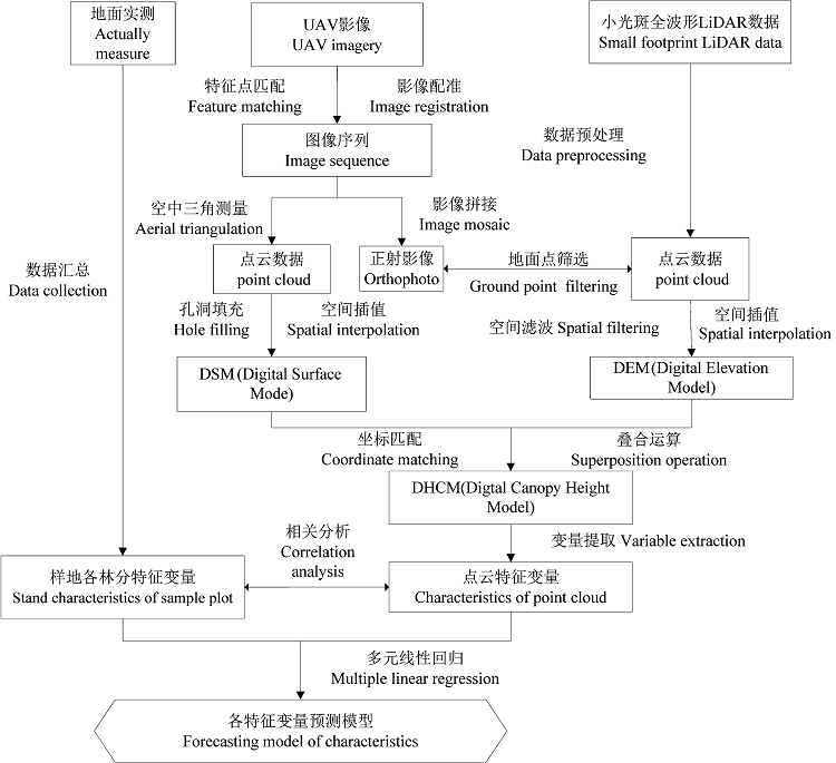
图2 研究技术路线图。
Fig. 2 Technical flow chart for this study.
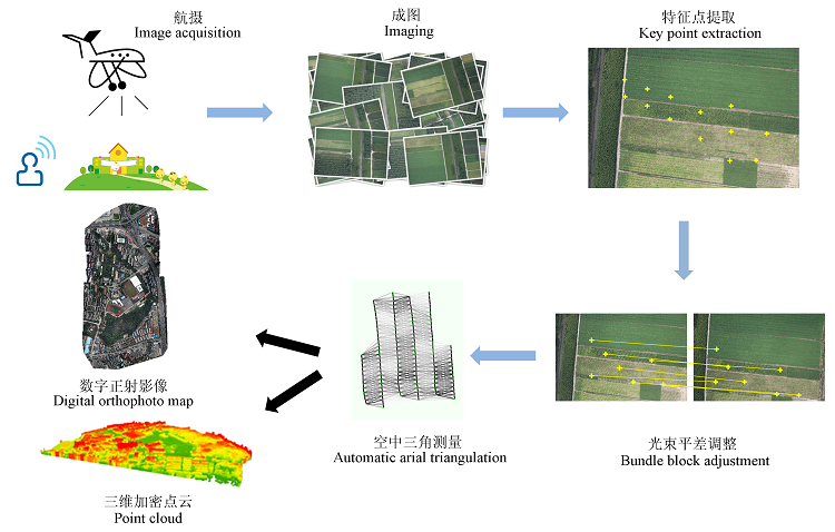
图3 UAV数据处理图。
Fig. 3 Procedures for processing the UAV data.
| 自变量(归一化点云提取参数) Independent variable | 因变量(实测参数) Dependent variable |
|---|---|
| 高度分位数 Height percentile (h10, h25, h30, h40, h60, h75, h85, h90) | Lorey’s树高 Lorey’s height (m) 林分密度 Stand density (plant·hm-2) 胸高断面积 Basal area (m2·hm-2) 蓄积量 Volume (m3·hm-2) |
| 点云密度变量 Point cloud density variables (d10, d25, d30, d40, d60, d75, d85, d90) | |
| 高度均值 Average height (havg) 高度最值 Maximum/minimal height (hmax, hmin) |
表3 多元回归分析变量表
Table 3 List of independent variables for this study
| 自变量(归一化点云提取参数) Independent variable | 因变量(实测参数) Dependent variable |
|---|---|
| 高度分位数 Height percentile (h10, h25, h30, h40, h60, h75, h85, h90) | Lorey’s树高 Lorey’s height (m) 林分密度 Stand density (plant·hm-2) 胸高断面积 Basal area (m2·hm-2) 蓄积量 Volume (m3·hm-2) |
| 点云密度变量 Point cloud density variables (d10, d25, d30, d40, d60, d75, d85, d90) | |
| 高度均值 Average height (havg) 高度最值 Maximum/minimal height (hmax, hmin) |
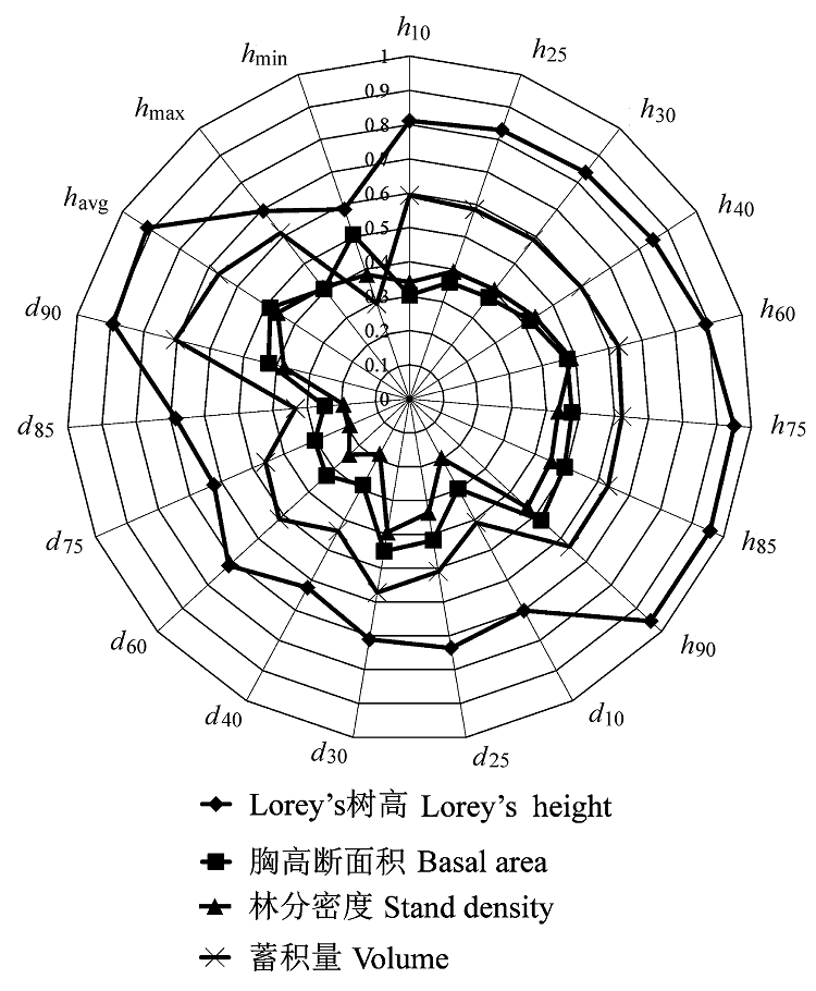
图4 点云特征变量与实测林分特征之间的相关分析。h10, h25……h90为相应高度百分位数; havg为算术平均高; hmax为最大高度; hmin为最小高度; d10, d25……d90为相应高度分位数点云密度。
Fig. 4 Analysis of coefficients between point-cloud metrics and stand characteristics. h10, h25…h90, height percentile; havg, average height; hmax, maximum height; hmin, minimal height; d10, d25… d90, point cloud density.
| 林分特征变量 Stand characteristics | 联合提取估算模型 Combined extraction estimation models | R2 | RMSE | rRMSE (%) |
|---|---|---|---|---|
| Lorey’s树高 Lorey’s height (H)(m) | H = 0.23 + 0.579havg + 0.346h90 | 0.86 | 0.13 | 6.47 |
| 林分密度 Stand density (N)(plant·hm-2) | N = 596.552 + 414.135h60 - 346.586h30 | 0.29 | 0.69 | 27.04 |
| 胸高断面积 Basal area (G)(m2·hm-2) | lnG = 2.752lnh60 - 1.841lnh10 - 1.126 | 0.53 | 0.28 | 16.38 |
| 蓄积量 Volume (V)(m3·hm-2) | lnV = 2.499 + 1.429lnh90 + 0.7lnd90 | 0.59 | 0.40 | 6.93 |
表4 联合提取估算模型及精度评价
Table 4 The integrated models and their accuracy assessments
| 林分特征变量 Stand characteristics | 联合提取估算模型 Combined extraction estimation models | R2 | RMSE | rRMSE (%) |
|---|---|---|---|---|
| Lorey’s树高 Lorey’s height (H)(m) | H = 0.23 + 0.579havg + 0.346h90 | 0.86 | 0.13 | 6.47 |
| 林分密度 Stand density (N)(plant·hm-2) | N = 596.552 + 414.135h60 - 346.586h30 | 0.29 | 0.69 | 27.04 |
| 胸高断面积 Basal area (G)(m2·hm-2) | lnG = 2.752lnh60 - 1.841lnh10 - 1.126 | 0.53 | 0.28 | 16.38 |
| 蓄积量 Volume (V)(m3·hm-2) | lnV = 2.499 + 1.429lnh90 + 0.7lnd90 | 0.59 | 0.40 | 6.93 |
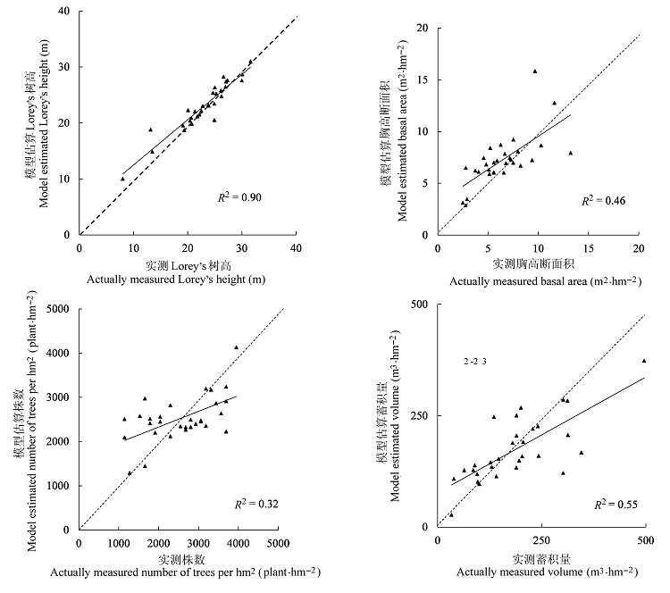
图5 各林分特征值与模型估算值对比(虚线为1:1验证线)。
Fig. 5 Comparison of field-measured characteristics and the estimates from model (the dotted line is 1:1 validation line).
| [1] | Azzari G, Goulden ML, Rusu RB (2013). Rapid characterization of vegetation structure with a microsoft kinect sensor.Sensors, 13, 2384-2398. |
| [2] | Cao L, Dai JS, Xu JX, Xu ZQ, She GH (2014). Optimized extraction of forest parameters in subtropical forests based on airborne small footprint LiDAR technology.Journal of Beijing Forestry University, 36(5), 13-21. |
| (in Chinese with English abstract) [曹林, 代劲松, 徐建新, 许子乾, 佘光辉 (2014). 基于机载小光斑 LiDAR 技术的亚热带森林参数信息优化提取. 北京林业大学学报, 36(5), 13-21.] | |
| [3] | Cao L, She GH, Dai JS, Xu JX (2013). Status and prospects of the LiDAR-based forest biomass estimation. Journal of Nanjing Forestry University (Natural Sciences Edition), 37(3), 163-169. |
| (in Chinese with English abstract) [曹林, 佘光辉, 代劲松, 徐建新 (2013). 激光雷达技术估测森林生物量的研究现状及展望. 南京林业大学学报(自然科学版), 37(3), 163-169.] | |
| [4] | Dandois JP, Ellis EC (2013). High spatial resolution three-dimensional mapping of vegetation spectral dynamics using computer vision.Remote Sensing of Environment, 136, 259-276. |
| [5] | Duncanson L, Niemann KO, Wulder M (2010). Integration of GLAS and Landsat TM data for aboveground biomass estimation.Canadian Journal of Remote Sensing, 36, 129-141. |
| [6] | Fu T, Pang Y, Huang QF, Liu QW, Xu GC (2011). Prediction of subtropical forest parameters using airborne laser scanner.Journal of Remote Sensing, 15, 1092-1104. |
| (in Chinese with English abstract) [付甜, 庞勇, 黄庆丰, 刘清旺, 徐光彩 (2011). 亚热带森林参数的机载激光雷达估测. 遥感学报, 15, 1092-1104.] | |
| [7] | Harwin S, Lucieer A (2012). Assessing the accuracy of georeferenced point clouds produced via multi-view stereopsis from Unmanned Aerial Vehicle (UAV) imagery.Remote Sensing, 4, 1573-1599. |
| [8] | He QS, Chen EX, Cao CX, Liu QW, Pang Y (2009). A study of forest parameters mapping technique using airborne LIDAR data.Advances in Earth Science, 24, 749-755. |
| (in Chinese with English abstract) [何祺胜, 陈尔学, 曹春香, 刘清旺, 庞勇 (2009). 基于LIDAR数据的森林参数反演方法研究. 地球科学进展, 24, 748-755.] | |
| [9] | Jiang XJ, Song ZF, Wu QH (2010). Conversion method between local independent coordinate system and WGS-84 coordinate system as well as its applications.Railway Investigation and Surveying, 36(4), 8-10, 13. |
| (in Chinese with English abstract) [蒋小军, 宋占峰, 吴清华(2010). 地方独立坐标系与WGS-84坐标系转换方法及应用. 铁道勘察, 36(4), 8-10, 13.] | |
| [10] | Lefsky MA, Cohen WB, Spies TA (2001). An evaluation of alternate remote sensing products for forest inventory, monitoring, and mapping of Douglas-fir forests in western Oregon.Canadian Journal of Forest Research, 31, 78-87. |
| [11] | Li DR, Wang CW, Hu YM, Liu SG (2012). General review on remote sensing-based biomass estimation.Geomatics and Information Science of Wuhan University, 37, 631-635. |
| (in Chinese with English abstract) [李德仁, 王长委, 胡月明, 刘曙光 (2012). 遥感技术估算森林生物量的研究进展. 武汉大学学报(信息科学版), 37, 631-635.] | |
| [12] | Liu DQ, Fan WY, Li MZ (2012). Estimation of forest stand parameters and biomass by small-footprint LIDAR.Journal of Northeast Forestry University, 40(1), 39-43. |
| (in Chinese with English abstract) [刘东起, 范文义, 李明泽 (2012). 利用小光斑激光雷达估测林分参数和生物量. 东北林业大学学报, 40(1), 39-43.] | |
| [13] | Lucieer A, Turner D, King DH, Robinson SA (2014). Using an Unmanned Aerial Vehicle (UAV) to capture micro- topography of Antarctic moss beds.International Journal of Applied Earth Observation and Geoinformation, 27, 53-62. |
| [14] | Mathews AJ, Jensen JLR (2013). Visualizing and quantifying vineyard canopy LAI using an Unmanned Aerial Vehicle (UAV) collected high density structure from motion point cloud.Remote Sensing, 5, 2164-2183. |
| [15] | Morgenroth J, Gomez C (2014). Assessment of tree structure using a 3D image analysis technique—A proof of concept.Urban Forestry & Urban Greening, 13, 198-203. |
| [16] | Næsset E (2002). Predicting forest stand characteristics with airborne scanning laser using a practical two-stage procedure and field data.Remote Sensing of Environment, 80, 88-99. |
| [17] | Pang Y, Li ZY (2012). Inversion of biomass components of the temperate forest using airborne Lidar technology in Xiaoxing’an Mountains, Northeastern of China.Chinese Journal of Plant Ecology, 36, 1095-1105. |
| (in Chinese with English abstract) [庞勇, 李增元 (2012). 基于机载激光雷达的小兴安岭温带森林组分生物量反演. 植物生态学报, 36, 1095-1105.] | |
| [18] | Pang Y, Li ZY, Chen EX, Sun GQ (2005). Lidar remote sensing technology and its application in forestry.Scientia Silvae Sinicae, 41(3), 129-136. |
| (in Chinese with English abstract) [庞勇, 李增元, 陈尔学, 孙国清 (2005). 激光雷达技术及其在林业上的应用. 林业科学, 41(3), 129-136.] | |
| [19] | Popescu SC (2007). Estimating biomass of individual pine trees using airborne LiDAR.Biomass and Bioenergy, 31, 646-655. |
| [20] | Turner D, Lucieer A, Watson C (2012). An automated technique for generating georectified mosaics from ultra-high resolution Unmanned Aerial Vehicle (UAV) imagery based on Structure from Motion (SFM) point clouds.Remote Sensing, 4, 1392-1410. |
| [21] | Wallace L, Lucieer A, Watson C, Turner D (2012). Development of a UAV-LiDAR system with application to forest inventory.Remote Sensing, 4, 1519-1543. |
| [22] | Westoby MJ, Brasington J, Glasser NF, Hambrey MJ, Reynolds JM (2012). ‘Structure-from-Motion’ photogrammetry: A low-cost, effective tool for geoscience applications.Geomorphology, 179, 300-314. |
| [23] | Wulder MA, White JC, Stinson G, Hilker T, Kurz WA, Coops NC, St-Onge B, Trofymow JA (2010). Implications of differing input data sources and approaches upon forest carbon stock estimation.Environmental Monitoring and Assessment, 166, 543-561. |
| [24] | Xu SQ, Zhang XF, Zhou KF, Zhao TY (2007). Discussion of the seven-parameter coordinate transformation between WGS-84 and BJ-54.Geomatics & Spatial Information Technology, 30(5), 33-38, 42. |
| (in Chinese with English abstract) [徐仕琪, 张晓帆, 周可法, 赵同阳 (2007). 关于利用七参数法进行WGS-84和BJ-54坐标转换问题的探讨. 测绘与空间地理信息, 30(5), 33-38, 42.] | |
| [25] | Zarco-Tejada PJ, Diaz-Varela R, Angileri V, Loudjani P (2014). Tree height quantification using very high resolution imagery acquired from an unmanned aerial vehicle (UAV) and automatic 3D photo-reconstruction methods.European Journal of Agronomy, 55, 89-99. |
| [26] | Zhao F (2007). Forest Parameter Extraction Using LiDAR Data and Digital Camera Image. PhD dissertation, Chinese Academy of Forestry, Beijing. |
| (in Chinese) [赵峰 (2007). 机载激光雷达数据和数码相机影像林木参数提取研究. 博士学位论文. 中国林业科学研究院, 北京.] |
| [1] | 万冬梅, 杨智杰, 刘小飞, 熊德成, 胥超, 陈仕东, 杨玉盛. 基于固态激光雷达测高法的亚热带幼树生长物候及其对环境因子的响应[J]. 植物生态学报, 2025, 49(12): 2080-2091. |
| [2] | 郝晴, 黄昌. 森林地上生物量遥感估算研究综述[J]. 植物生态学报, 2023, 47(10): 1356-1374. |
| [3] | 田佳玉, 王彬, 张志明, 林露湘. 光谱多样性在植物多样性监测与评估中的应用[J]. 植物生态学报, 2022, 46(10): 1129-1150. |
| [4] | 王嘉童, 牛春跃, 胡天宇, 李文楷, 刘玲莉, 郭庆华, 苏艳军. 三维辐射传输模型在森林生态系统研究中的应用与展望[J]. 植物生态学报, 2022, 46(10): 1200-1218. |
| [5] | 刘兵兵, 魏建新, 胡天宇, 杨秋丽, 刘小强, 吴发云, 苏艳军, 郭庆华. 卫星遥感监测产品在中国森林生态系统的验证和不确定性分析——基于海量无人机激光雷达数据[J]. 植物生态学报, 2022, 46(10): 1305-1316. |
| [6] | 衣海燕, 曾源, 赵玉金, 郑朝菊, 熊杰, 赵旦. 利用聚类算法监测森林乔木物种多样性[J]. 植物生态学报, 2020, 44(6): 598-615. |
| [7] | 郭庆华, 胡天宇, 马勤, 徐可心, 杨秋丽, 孙千惠, 李玉美, 苏艳军. 新一代遥感技术助力生态系统生态学研究[J]. 植物生态学报, 2020, 44(4): 418-435. |
| [8] | 张瑞英, 庞勇, 李增元, 包玉海. 结合机载LiDAR和LANDSAT ETM+数据的温带森林郁闭度估测[J]. 植物生态学报, 2016, 40(2): 102-115. |
| [9] | 郝蕊芳, 于德永, 邬建国, 郭勤峰, 刘宇鹏. 约束线方法在生态学研究中的应用[J]. 植物生态学报, 2016, 40(10): 1100-1109. |
| [10] | 徐婷, 曹林, 申鑫, 佘光辉. 基于机载激光雷达与Landsat 8 OLI数据的亚热带森林生物量估算[J]. 植物生态学报, 2015, 39(4): 309-321. |
| [11] | 庞勇, 李增元. 基于机载激光雷达的小兴安岭温带森林组分生物量反演[J]. 植物生态学报, 2012, 36(10): 1095-1105. |
| 阅读次数 | ||||||
|
全文 |
|
|||||
|
摘要 |
|
|||||
Copyright © 2026 版权所有 《植物生态学报》编辑部
地址: 北京香山南辛村20号, 邮编: 100093
Tel.: 010-62836134, 62836138; Fax: 010-82599431; E-mail: apes@ibcas.ac.cn, cjpe@ibcas.ac.cn
备案号: 京ICP备16067583号-19
![]()