
植物生态学报 ›› 2012, Vol. 36 ›› Issue (10): 1095-1105.DOI: 10.3724/SP.J.1258.2012.01095
庞勇*( ), 李增元
收稿日期:2012-02-13
接受日期:2012-07-23
出版日期:2012-02-13
发布日期:2012-09-26
通讯作者:
庞勇
作者简介: E-mail: caf.pang@gmail.com
PANG Yong*(), LI Zeng-Yuan
Received:2012-02-13
Accepted:2012-07-23
Online:2012-02-13
Published:2012-09-26
Contact:
PANG Yong
摘要:
使用小兴安岭温带森林机载遥感-地面观测同步试验获取的机载激光雷达(light detection and ranging, Lidar)点云数据和地面实测样地数据, 估测了典型森林类型的树叶、树枝、树干、地上、树根和总生物量等组分的生物量。从激光雷达数据中提取了两组变量(树冠高度变量组和植被密度变量组)作为自变量, 并采用逐步回归方法进行自变量选择。结果表明: 激光雷达数据得到的变量与森林各组分生物量有很强的相关性; 对于针叶林、阔叶林和针阔叶混交林三种不同森林类型生物量的估测结果是: 针叶林优于阔叶林, 阔叶林优于针阔叶混交林; 不区分森林类型的各组分生物量估测与地面实测值显著相关, 模型决定系数在0.6以上; 区分森林类型进行建模可以进一步提高生物量的估测精度。
庞勇, 李增元. 基于机载激光雷达的小兴安岭温带森林组分生物量反演. 植物生态学报, 2012, 36(10): 1095-1105. DOI: 10.3724/SP.J.1258.2012.01095
PANG Yong, LI Zeng-Yuan. Inversion of biomass components of the temperate forest using airborne Lidar technology in Xiaoxing’an Mountains, Northeastern of China. Chinese Journal of Plant Ecology, 2012, 36(10): 1095-1105. DOI: 10.3724/SP.J.1258.2012.01095
| 评价指标 Evaluation index | 森林类型 Forest type | 组分生物量 Biomass component | |||||
|---|---|---|---|---|---|---|---|
| Wf | Wb | Ws | Wa | Wr | Wt | ||
| 决定系数 Coefficient of determination R2 | 阔叶林 Broad-leaved forest | 0.44 | 0.44 | 0.60 | 0.60 | 0.43 | 0.64 |
| 针叶林 Needle-leaved forest | 0.82 | 0.91 | 0.87 | 0.88 | 0.84 | 0.89 | |
| 针阔叶混交林 Needle-broad-leaved mixed forest | 0.20 | 0.42 | 0.62 | 0.61 | 0.43 | 0.63 | |
| 均方根误差 Root mean square error RMSE | 阔叶林 Broad-leaved forest | 1.1 | 2.0 | 17.1 | 19.3 | 4.4 | 21.5 |
| 针叶林 Needle-leaved forest | 1.1 | 1.4 | 17.3 | 20.0 | 2.3 | 20.2 | |
| 针阔叶混交林 Needle-broad-leaved mixed forest | 1.8 | 4.0 | 66.6 | 68.2 | 6.1 | 69.1 | |
| 相对均方根误差 Relative root mean square error rRMSE | 阔叶林 Broad-leaved forest | 0.36 | 0.23 | 0.22 | 0.21 | 0.21 | 0.19 |
| 针叶林 Needle-leaved forest | 0.21 | 0.15 | 0.18 | 0.18 | 0.18 | 0.16 | |
| 针阔叶混交林 Needle-broad-leaved mixed forest | 0.28 | 0.25 | 0.27 | 0.26 | 0.23 | 0.24 | |
表1 按不同森林类型进行统计的组分生物量回归模型结果
Table 1 Results of biomass component regression models from different forest types
| 评价指标 Evaluation index | 森林类型 Forest type | 组分生物量 Biomass component | |||||
|---|---|---|---|---|---|---|---|
| Wf | Wb | Ws | Wa | Wr | Wt | ||
| 决定系数 Coefficient of determination R2 | 阔叶林 Broad-leaved forest | 0.44 | 0.44 | 0.60 | 0.60 | 0.43 | 0.64 |
| 针叶林 Needle-leaved forest | 0.82 | 0.91 | 0.87 | 0.88 | 0.84 | 0.89 | |
| 针阔叶混交林 Needle-broad-leaved mixed forest | 0.20 | 0.42 | 0.62 | 0.61 | 0.43 | 0.63 | |
| 均方根误差 Root mean square error RMSE | 阔叶林 Broad-leaved forest | 1.1 | 2.0 | 17.1 | 19.3 | 4.4 | 21.5 |
| 针叶林 Needle-leaved forest | 1.1 | 1.4 | 17.3 | 20.0 | 2.3 | 20.2 | |
| 针阔叶混交林 Needle-broad-leaved mixed forest | 1.8 | 4.0 | 66.6 | 68.2 | 6.1 | 69.1 | |
| 相对均方根误差 Relative root mean square error rRMSE | 阔叶林 Broad-leaved forest | 0.36 | 0.23 | 0.22 | 0.21 | 0.21 | 0.19 |
| 针叶林 Needle-leaved forest | 0.21 | 0.15 | 0.18 | 0.18 | 0.18 | 0.16 | |
| 针阔叶混交林 Needle-broad-leaved mixed forest | 0.28 | 0.25 | 0.27 | 0.26 | 0.23 | 0.24 | |
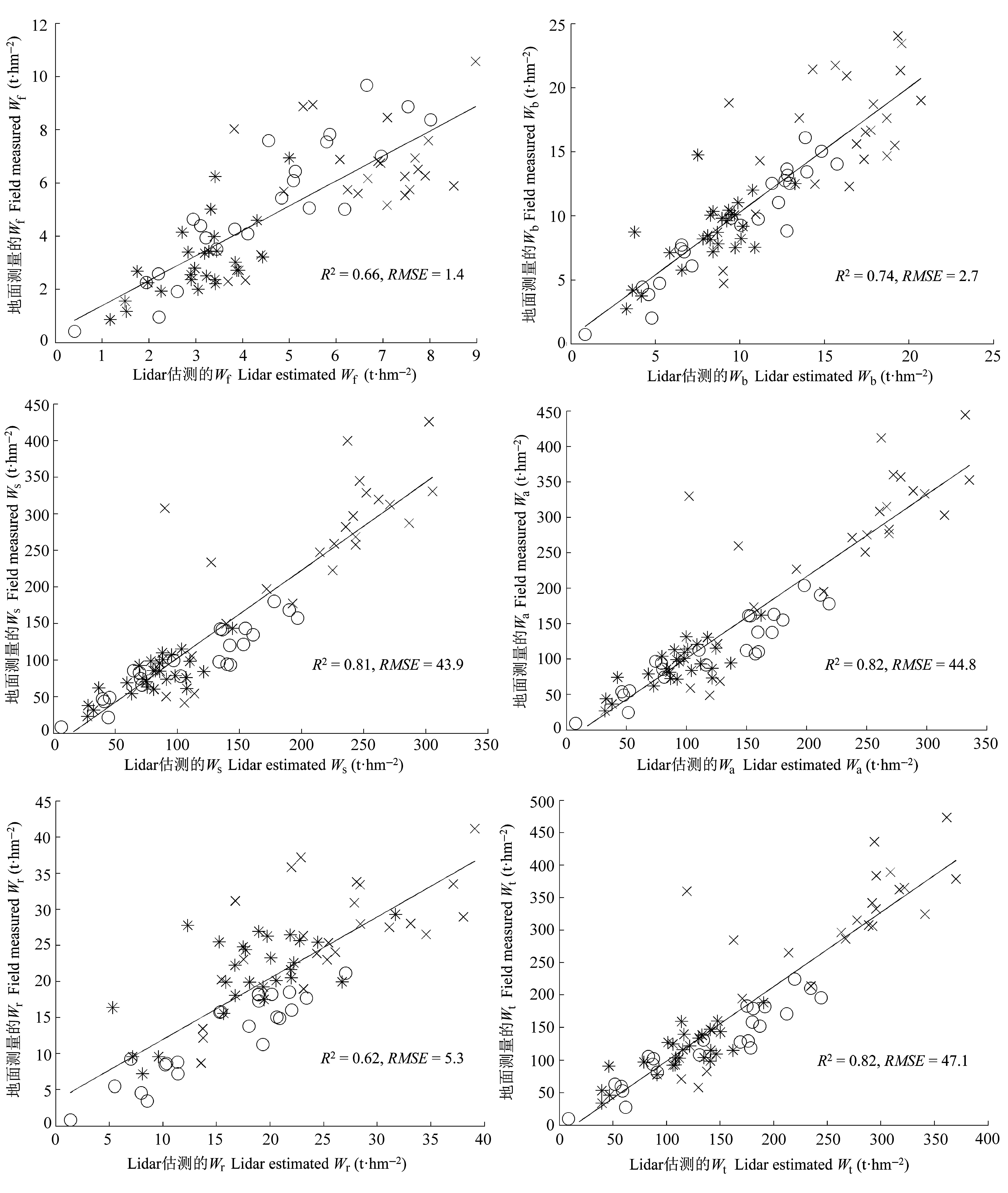
图1 样地各组分生物量实测值与激光雷达估测值的对比(单位为: t·hm-2)。*, 阔叶林; ○, 针叶林; × , 针阔叶混交林; R2, 决定系数; RMSE, 均方根误差; Wa, 地上总生物量; Wb, 活枝生物量; Wf, 叶生物量; Wr, 根生物量; Ws, 树干生物量; Wt, 总生物量。
Fig. 1 Comparison of estimated biomass components from field measurements and airborne Lidar (unit: t·hm-2). *, broad-leaved forest; ○, needle-leaved forest; × , needle-broad-leaved mixed forest; R2, coefficient of determination; RMSE, root mean square error; Wa, aboveground biomass; Wb, live branch biomass; Wf, leaf biomass; Wr, root biomass; Ws, trunk biomass; Wt, total biomass.
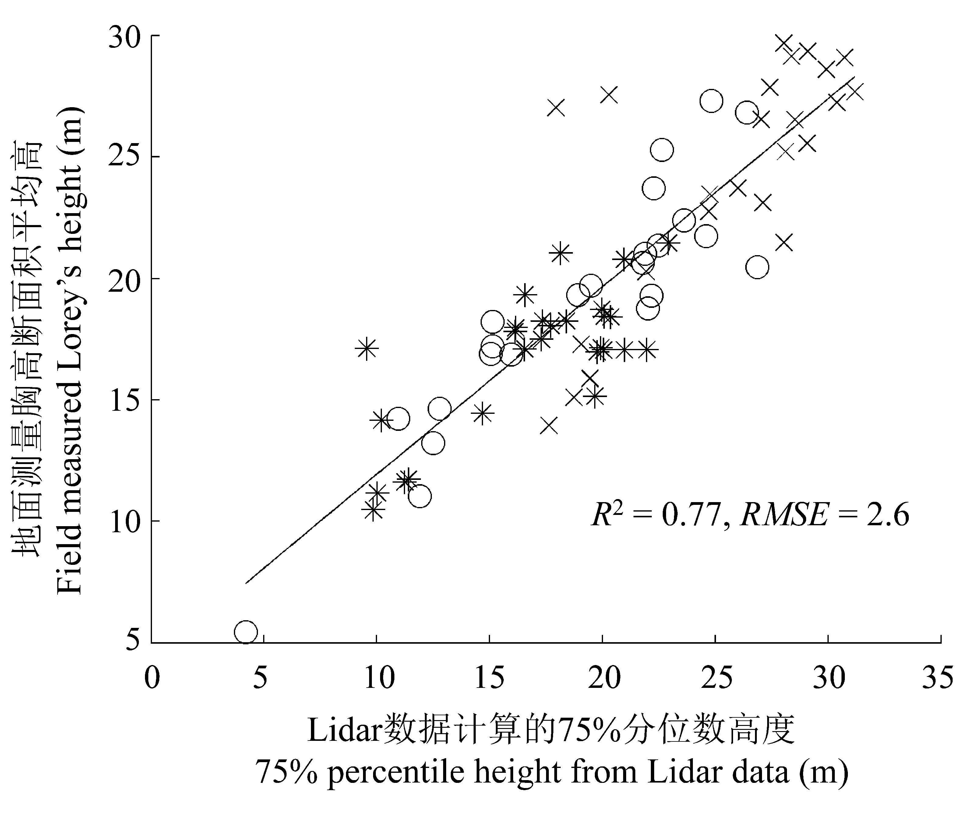
图2 地面测量胸高断面积平均高与激光雷达75%分位数高度的对比。*, 阔叶林; ○, 针叶林; × , 针阔叶混交林; R2, 决定系数; RMSE, 均方根误差。
Fig. 2 Comparison of Lorey’s height (basal area weighted mean height) from field measurements and 75% percentile height from airborne Lidar data. *, broad-leaved forest; ○, needle-leaved forest; × , needle-broad-leaved mixed forest; R2, coefficient of determination; RMSE, root mean square error.
| 评价指标 Evaluation index | 森林类型 Forest type | 组分生物量 Biomass component | ||||||
|---|---|---|---|---|---|---|---|---|
| Wf | Wb | Ws | Wa | Wr | Wt | |||
| 决定系数 Coefficient of determination R2 | 阔叶林 Broad-leaved forest | 0.96 | 0.92 | 0.89 | 0.88 | 0.82 | 0.95 | |
| 针叶林 Needle-leaved forest | 0.97 | 0.91 | 0.97 | 0.95 | 0.85 | 0.95 | ||
| 针阔叶混交林 Needle-broad-leaved mixed forest | 0.82 | 0.61 | 0.79 | 0.80 | 0.79 | 0.82 | ||
| 均方根误差 Root mean square error RMSE | 阔叶林 Broad-leaved forest | 0.30 | 0.80 | 8.90 | 10.30 | 2.50 | 8.10 | |
| 针叶林 Needle-leaved forest | 0.50 | 1.30 | 8.30 | 12.20 | 2.20 | 13.30 | ||
| 针阔叶混交林 Needle-broad-leaved mixed forest | 0.90 | 3.30 | 49.5 | 48.90 | 3.70 | 48.90 | ||
| 相对均方根误差 Relative root mean square error rRMSE | 阔叶林 Broad-leaved forest | 0.10 | 0.09 | 0.11 | 0.11 | 0.12 | 0.07 | |
| 针叶林 Needle-leaved forest | 0.10 | 0.14 | 0.08 | 0.11 | 0.18 | 0.11 | ||
| 针阔叶混交林 Needle-broad-leaved mixed forest | 0.14 | 0.20 | 0.20 | 0.18 | 0.14 | 0.17 | ||
表2 用不同森林类型进行变量筛选、建立回归模型时的组分生物量模拟结果
Table 2 Results of biomass component regression models from variable selection and model establishment categoried by forest types
| 评价指标 Evaluation index | 森林类型 Forest type | 组分生物量 Biomass component | ||||||
|---|---|---|---|---|---|---|---|---|
| Wf | Wb | Ws | Wa | Wr | Wt | |||
| 决定系数 Coefficient of determination R2 | 阔叶林 Broad-leaved forest | 0.96 | 0.92 | 0.89 | 0.88 | 0.82 | 0.95 | |
| 针叶林 Needle-leaved forest | 0.97 | 0.91 | 0.97 | 0.95 | 0.85 | 0.95 | ||
| 针阔叶混交林 Needle-broad-leaved mixed forest | 0.82 | 0.61 | 0.79 | 0.80 | 0.79 | 0.82 | ||
| 均方根误差 Root mean square error RMSE | 阔叶林 Broad-leaved forest | 0.30 | 0.80 | 8.90 | 10.30 | 2.50 | 8.10 | |
| 针叶林 Needle-leaved forest | 0.50 | 1.30 | 8.30 | 12.20 | 2.20 | 13.30 | ||
| 针阔叶混交林 Needle-broad-leaved mixed forest | 0.90 | 3.30 | 49.5 | 48.90 | 3.70 | 48.90 | ||
| 相对均方根误差 Relative root mean square error rRMSE | 阔叶林 Broad-leaved forest | 0.10 | 0.09 | 0.11 | 0.11 | 0.12 | 0.07 | |
| 针叶林 Needle-leaved forest | 0.10 | 0.14 | 0.08 | 0.11 | 0.18 | 0.11 | ||
| 针阔叶混交林 Needle-broad-leaved mixed forest | 0.14 | 0.20 | 0.20 | 0.18 | 0.14 | 0.17 | ||
| 1 | Axelsson P (2001). Ground estimation of laser data using adaptive TIN-models. In: Torlegård K, Nelson J eds. Proceedings of OEEPE Workshop on Airborne Laserscanning and Interferometric SAR for Detailed Digital Elevation Models. Royal Institute of Technology, Stockholm,Sweden. 185-208. |
| 3 | Chen CG ( 陈传国), Zhu JF ( 朱俊凤 ) (1989). Woody Biomass Manual of Typical Species in the Northeast of China (东北主要林木生物量手册). China Forestry Publishing House, Beijing. (in Chinese) |
| 4 | Feng ZW ( 冯宗炜), Wang XK ( 王效科), Wu G ( 吴刚 ) (1999). Biomass and Productivity of Chinese Forest Ecosystem (中国森林生态系统的生物量和生产力). Science Press, Beijing. (in Chinese) |
| 5 | Fu T ( 付甜), Pang Y ( 庞勇), Huang QF ( 黄庆丰), Liu QW ( 刘清旺), Xu GC ( 徐光彩 ) ( 2011). Subtropical forest parameters estimation using airborne Lidar data. Journal of Remote Sensing (遥感学报), 15, 1092-1098. (in Chinese with English abstract) |
| 6 | Hall SA, Burke IC, Box DO, Kaufmann MR, Stoker JM ( 2005). Estimating stand structure using discrete-return lidar: an example from low density, fire prone ponderosa pine forests. Forest Ecology and Management, 208, 189-209. |
| 7 | Holmgren J ( 2004). Prediction of tree height, basal area and stem volume in forest stands using airborne laser scanning. Scandinavian Journal of Forest Research, 19, 543-553. |
| 8 | Latifi H, Nothdurft A, Koch B ( 2010). Non-parametric prediction and mapping of standing timber volume and biomass in a temperate forest: application of multiple optical/ LiDAR-derived predictors. Forestry, 83, 395-407. |
| 9 | Lim KS, Treitz PM ( 2004). Estimation of aboveground forest biomass from airborne discrete return laser scanner data using canopy-based quantile estimators. Scandinavian Journal of Forest Research, 19, 558-570. |
| 10 | Liu QW ( 刘清旺), Li ZY ( 李增元), Chen EX ( 陈尔学), Pang Y ( 庞勇), Tian X ( 田欣), Cao CX ( 曹春香 ) ( 2010). Estimating biomass of individual trees using point cloud data of airborne Lidar. Chinese High Technology Letters (高技术通讯), 20, 765-770. (in Chinese with English abstract) |
| 11 | MacLean GA, Krabill WB ( 1986). Gross merchantable timber volume estimation using an airborne LiDAR system. Canadian Journal of Remote Sensing, 12, 7-l8. |
| 12 | Maltamo M, Eerikäinen K, Pitkänen J, Hyyppä J, Vehmas M ( 2004). Estimation of timber volume and stem density based on scanning laser altimetry and expected tree size distribution functions. Remote Sensing of Environment, 90, 319-330. |
| 13 | Næsset E ( 1997). Determination of mean tree height of forest stands using airborne laser scanner data. ISPRS Journal of Photogrammetry and Remote Sensing, 52, 49-56. |
| 14 | Næsset E, Gobakken T ( 2008). Estimation of above- and below-ground biomass across regions of the boreal forest zone using airborne laser. Remote Sensing of Environment, 112, 3079-3090. |
| 15 | Nelson R, Krabill W, MacLean G ( 1984). Determining forest canopy characteristics using airborne laser data. Remote Sensing of Environment, 15, 201-212. |
| 16 | Nelson R, Krabill W, Tonelli J ( 1988). Estimating forest biomass and volume using airborne laser data. Remote Sensing of Environment, 24, 247-267. |
| 17 | Nelson R, Oderwald R, Gregoire TG ( 1997). Separating the ground and airborne laser sampling phases to estimate tropical forest basal area, volume, and biomass. Remote Sensing of Environment, 60, 311-326. |
| 18 | Nilsson M ( 1996). Estimation of tree heights and stand volume using an airborne Lidar system. Remote Sensing of Environment, 56, 1-7. |
| 19 |
Pang Y ( 庞勇), Li ZY ( 李增元), Chen EX ( 陈尔学), Sun GQ ( 孙国清 ) ( 2005). Lidar remote sensing technology and its application in forestry. Scientia Silvae Sinicae (林业科学), 41(3), 129-136. (in Chinese with English abstract)
DOI URL |
| 20 | Pang Y ( 庞勇), Zhao F ( 赵峰), Li ZY ( 李增元), Zhou SF ( 周淑芳), Deng G ( 邓广), Liu Q ( 刘清旺), Chen E ( 陈尔学 ) ( 2008). Forest height inversion using airborne Lidar technology. Journal of Remote Sensing (遥感学报), 12, 152-158. (in Chinese with English abstract) |
| 21 | Popescu SC ( 2007). Estimating biomass of individual pine trees using airborne Lidar. Biomass and Bioenergy, 31, 646-655. |
| 22 | Wang C ( 2006). Biomass allometric equations for 10 co- occurring tree species in Chinese temperate forests. Forest Ecology and Management, 222, 9-16. |
| 23 | Zhao K, Popescu S, Nelson R ( 2009). Lidar remote sensing of forest biomass: a scale-invariant estimation approach using airborne lasers. Remote Sensing of Environment, 113, 182-196. |
| [1] | 黄玲, 王榛, 马泽, 杨发林, 李岚, SEREKPAYEV Nurlan, NOGAYEV Adilbek, 侯扶江. 长期放牧和氮添加对黄土高原典型草原长芒草种群生长的影响[J]. 植物生态学报, 2024, 48(3): 317-330. |
| [2] | 赵艳超, 陈立同. 土壤养分对青藏高原高寒草地生物量响应增温的调节作用[J]. 植物生态学报, 2023, 47(8): 1071-1081. |
| [3] | 郝晴, 黄昌. 森林地上生物量遥感估算研究综述[J]. 植物生态学报, 2023, 47(10): 1356-1374. |
| [4] | 董六文, 任正炜, 张蕊, 谢晨笛, 周小龙. 功能多样性比物种多样性更好解释氮添加对高寒草地生物量的影响[J]. 植物生态学报, 2022, 46(8): 871-881. |
| [5] | 董涵君, 王兴昌, 苑丹阳, 柳荻, 刘玉龙, 桑英, 王晓春. 温带不同材性树种树干非结构性碳水化合物的径向分配差异[J]. 植物生态学报, 2022, 46(6): 722-734. |
| [6] | 陈丽, 田新民, 任正炜, 董六文, 谢晨笛, 周小龙. 养分添加对天山高寒草地植物多样性和地上生物量的影响[J]. 植物生态学报, 2022, 46(3): 280-289. |
| [7] | 于海英, 杨莉琳, 付素静, 张志敏, 姚琦馥. 暖温带森林木本植物展叶始期对低温和热量累积变化的响应[J]. 植物生态学报, 2022, 46(12): 1573-1584. |
| [8] | 黄侩侩, 胡刚, 庞庆玲, 张贝, 何业涌, 胡聪, 徐超昊, 张忠华. 放牧对中国亚热带喀斯特山地灌草丛物种组成与群落结构的影响[J]. 植物生态学报, 2022, 46(11): 1350-1363. |
| [9] | 陈哲, 汪浩, 王金洲, 石慧瑾, 刘慧颖, 贺金生. 基于物候相机归一化植被指数估算高寒草地植物地上生物量的季节动态[J]. 植物生态学报, 2021, 45(5): 487-495. |
| [10] | 魏春雪, 杨璐, 汪金松, 杨家明, 史嘉炜, 田大栓, 周青平, 牛书丽. 实验增温对陆地生态系统根系生物量的影响[J]. 植物生态学报, 2021, 45(11): 1203-1212. |
| [11] | 邹安龙,李修平,倪晓凤,吉成均. 模拟氮沉降对北京东灵山辽东栎林树木生长的影响[J]. 植物生态学报, 2019, 43(9): 783-792. |
| [12] | 苗百岭, 梁存柱, 史亚博, 梁茂伟, 刘钟龄. 降水变化对内蒙古典型草原地上生物量的影响[J]. 植物生态学报, 2019, 43(7): 557-565. |
| [13] | 赵丹丹, 马红媛, 李阳, 魏继平, 王志春. 水分和养分添加对羊草功能性状和地上生物量的影响[J]. 植物生态学报, 2019, 43(6): 501-511. |
| [14] | 杨倩, 王娓, 曾辉. 氮添加对内蒙古退化草地植物群落多样性和生物量的影响[J]. 植物生态学报, 2018, 42(4): 430-441. |
| [15] | 张璐, 郝匕台, 齐丽雪, 李艳龙, 徐慧敏, 杨丽娜, 宝音陶格涛. 草原群落生物量和土壤有机质含量对改良措施的动态响应[J]. 植物生态学报, 2018, 42(3): 317-326. |
| 阅读次数 | ||||||
|
全文 |
|
|||||
|
摘要 |
|
|||||
Copyright © 2022 版权所有 《植物生态学报》编辑部
地址: 北京香山南辛村20号, 邮编: 100093
Tel.: 010-62836134, 62836138; Fax: 010-82599431; E-mail: apes@ibcas.ac.cn, cjpe@ibcas.ac.cn
备案号: 京ICP备16067583号-19