
植物生态学报 ›› 2022, Vol. 46 ›› Issue (12): 1551-1561.DOI: 10.17521/cjpe.2021.0414 cstr: 32100.14.cjpe.2021.0414
所属专题: 生态遥感及应用
姜艳( ), 陈兴芳, 杨旭杰
收稿日期:2021-11-15
接受日期:2022-04-21
出版日期:2022-12-20
发布日期:2023-01-13
基金资助:
JIANG Yan(), CHEN Xing-Fang, YANG Xu-Jie
Received:2021-11-15
Accepted:2022-04-21
Online:2022-12-20
Published:2023-01-13
Supported by:摘要:
水生植物的动态分布可以反映水域生态环境的变化, 掌握水生植物的时空分布情况对湖泊的管理与监测具有重要意义。该研究基于Landsat影像数据, 结合归一化水体指数、绿度指数和藻类指数, 利用决策树分类方法, 构建武汉东湖水生植物的提取模型, 绘制了东湖2020年挺水/浮水植物和沉水植物的季节分布图和1990-2020年31期年际分布图。主要结果表明, 决策树模型能较为准确地获取东湖水生植物的分布情况, 其总体精度为82.29%, Kappa系数为72.39%。东湖水生植物季节性变化分析表明, 水生植物面积呈先增大后减少的趋势, 2月份东湖水生植物分布面积较小, 4-8月面积逐渐增加, 10月以后水生植物开始衰退。水生植物面积的年际变化较大, 可分为3个阶段: 第一阶段(1990-1996年)挺水/浮水植物的面积先减少后增大, 而沉水植物的面积持续增加; 第二阶段(1997-2015年)沉水植物与挺水/浮水植物面积的年际波动较大, 在此期间, 东湖水生植物最大面积为2.61 km2, 最小面积仅为0.49 km2; 第三阶段(2016-2020年)东湖水生植物逐渐恢复, 挺水/浮水植物面积增加30%, 沉水植物面积增加18%。通过研究30年来水生植物面积与年平均气温和年降水量的关系, 发现年平均气温和年降水量对东湖水生植物的影响较小。东湖中有水生植物的分布和无水生植物分布环境指标存在差异, 总磷含量、总氮含量、水深、透明度和浊度均可能影响水生植物的分布。
姜艳, 陈兴芳, 杨旭杰. 基于Landsat影像的武汉东湖30年来水生植物动态变化. 植物生态学报, 2022, 46(12): 1551-1561. DOI: 10.17521/cjpe.2021.0414
JIANG Yan, CHEN Xing-Fang, YANG Xu-Jie. Changes of aquatic plants in Donghu Lake of Wuhan based 1990-2020 Landsat images. Chinese Journal of Plant Ecology, 2022, 46(12): 1551-1561. DOI: 10.17521/cjpe.2021.0414
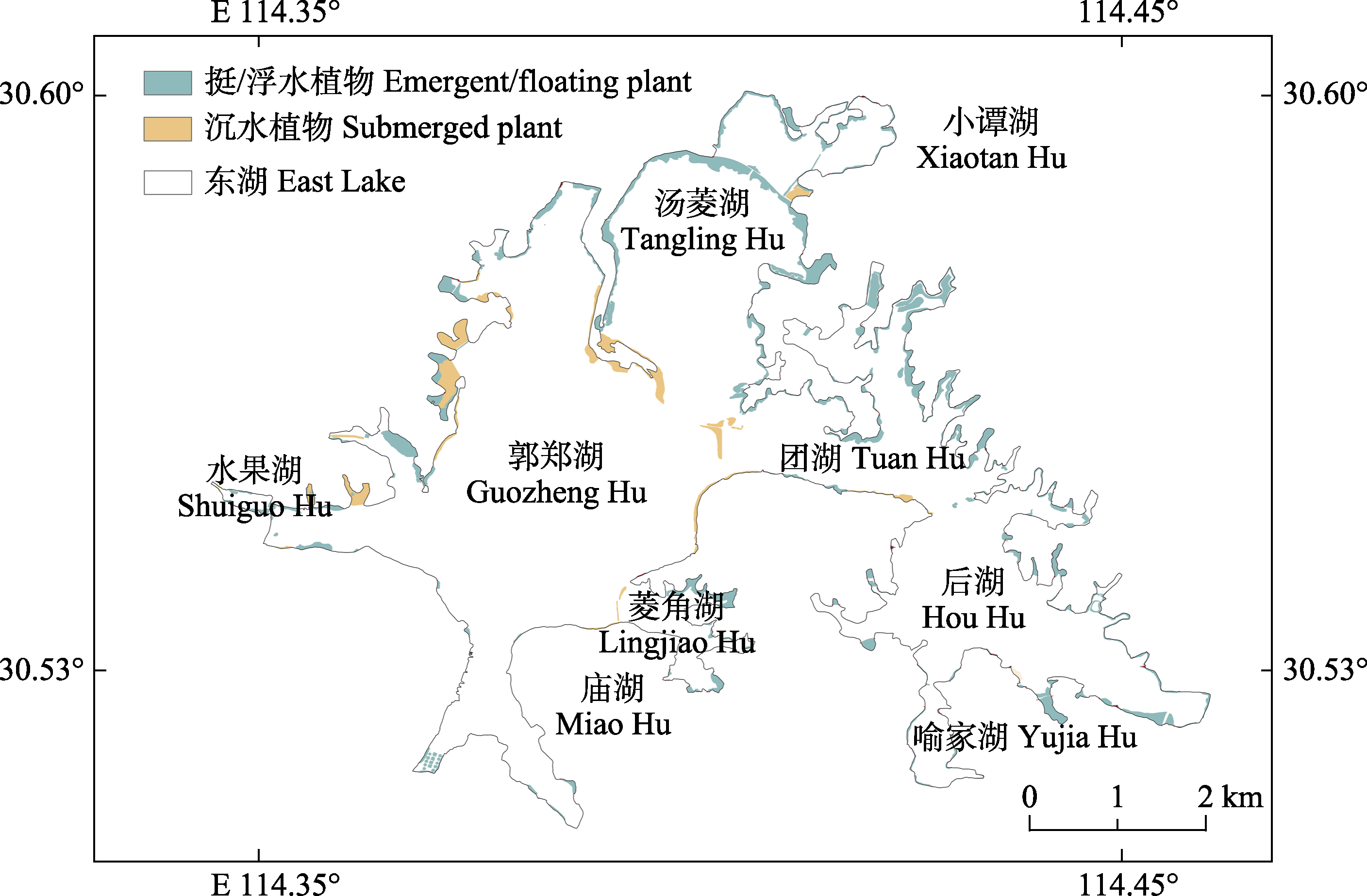
图1 2020年武汉东湖水生植物概况图。
Fig. 1 Location of aquatic plants in Donghu Lake in Wuhan in 2020.
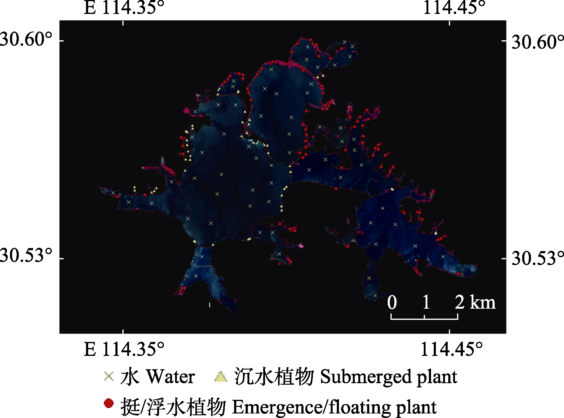
图2 武汉东湖水生植物采样点(部分)。
Fig. 2 Locations of field investigation sites in Donghu Lake in Wuhan (partial).
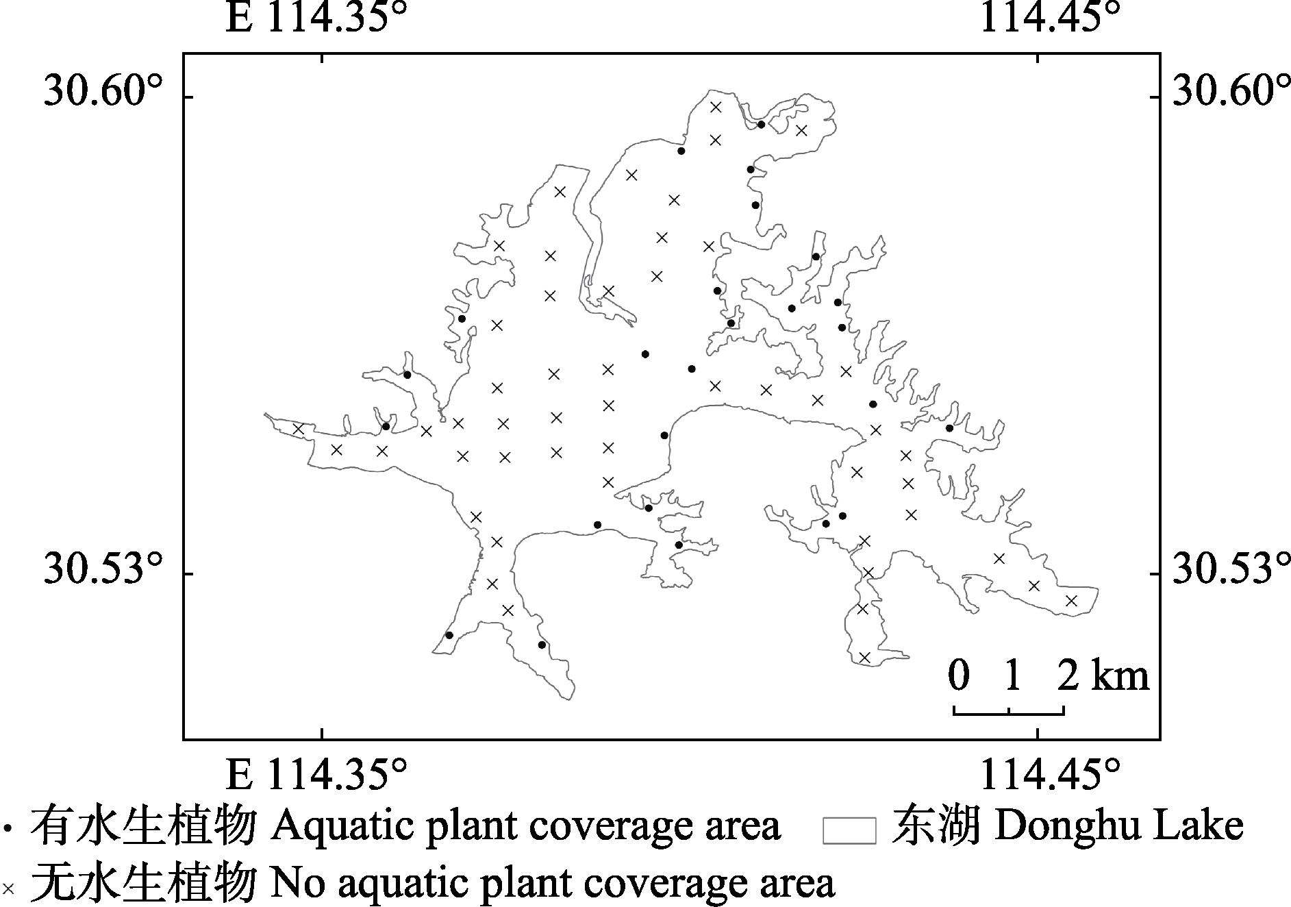
图3 武汉东湖水质采样点。
Fig. 3 Locations of water quality sampling point in Donghu Lake in Wuhan.
| 日期 Date | 传感器 Sensor | 日期 Date | 传感器 Sensor | 日期 Date | 传感器 Sensor |
|---|---|---|---|---|---|
| 1990-09-02 | Landsat-5/TM | 2002-09-03 | Landsat-5-TM | 2014-10-06 | Landsat-8 OLI |
| 1991-07-19 | Landsat-5/TM | 2003-10-24 | Landsat-5-TM | 2015-10-25 | Landsat-8 OLI |
| 1992-11-10 | Landsat-5/TM | 2004-07-31 | Landsat-5-TM | 2016-07-23 | Landsat-8 OLI |
| 1993-10-12 | Landsat-5/TM | 2005-09-11 | Landsat-5-TM | 2017-10-30 | Landsat-8 OLI |
| 1994-07-27 | Landsat-5/TM | 2006-11-01 | Landsat-5-TM | 2018-09-15 | Landsat-8 OLI |
| 1995-08-31 | Landsat-5/TM | 2007-07-31 | Landsat-5-TM | 2019-08-17 | Landsat-8 OLI |
| 1996-09-02 | Landsat-5/TM | 2008-12-08 | Landsat-5-TM | 2020-02-09 | Landsat-8 OLI |
| 1997-09-21 | Landsat-5/TM | 2009-09-06 | Landsat-5-TM | 2020-04-13 | Landsat-8 OLI |
| 1998-10-26 | Landsat-5/TM | 2010-11-05 | Landsat-5-TM | 2020-08-03 | Landsat-8 OLI |
| 1999-09-27 | Landsat-5/TM | 2011-06-08 | Landsat-5-TM | 2020-10-22 | Landsat-8 OLI |
| 2000-07-27 | Landsat-5/TM | 2012-05-17 | Landsat-7/ETM+ | ||
| 2001-09-16 | Landsat-5-TM | 2013-07-31 | Landsat-8 OLI |
表1 武汉东湖Landsat影像采集日期及传感器类型
Table 1 Landsat image acquisition date and sensor type of Donghu Lake in Wuhan
| 日期 Date | 传感器 Sensor | 日期 Date | 传感器 Sensor | 日期 Date | 传感器 Sensor |
|---|---|---|---|---|---|
| 1990-09-02 | Landsat-5/TM | 2002-09-03 | Landsat-5-TM | 2014-10-06 | Landsat-8 OLI |
| 1991-07-19 | Landsat-5/TM | 2003-10-24 | Landsat-5-TM | 2015-10-25 | Landsat-8 OLI |
| 1992-11-10 | Landsat-5/TM | 2004-07-31 | Landsat-5-TM | 2016-07-23 | Landsat-8 OLI |
| 1993-10-12 | Landsat-5/TM | 2005-09-11 | Landsat-5-TM | 2017-10-30 | Landsat-8 OLI |
| 1994-07-27 | Landsat-5/TM | 2006-11-01 | Landsat-5-TM | 2018-09-15 | Landsat-8 OLI |
| 1995-08-31 | Landsat-5/TM | 2007-07-31 | Landsat-5-TM | 2019-08-17 | Landsat-8 OLI |
| 1996-09-02 | Landsat-5/TM | 2008-12-08 | Landsat-5-TM | 2020-02-09 | Landsat-8 OLI |
| 1997-09-21 | Landsat-5/TM | 2009-09-06 | Landsat-5-TM | 2020-04-13 | Landsat-8 OLI |
| 1998-10-26 | Landsat-5/TM | 2010-11-05 | Landsat-5-TM | 2020-08-03 | Landsat-8 OLI |
| 1999-09-27 | Landsat-5/TM | 2011-06-08 | Landsat-5-TM | 2020-10-22 | Landsat-8 OLI |
| 2000-07-27 | Landsat-5/TM | 2012-05-17 | Landsat-7/ETM+ | ||
| 2001-09-16 | Landsat-5-TM | 2013-07-31 | Landsat-8 OLI |
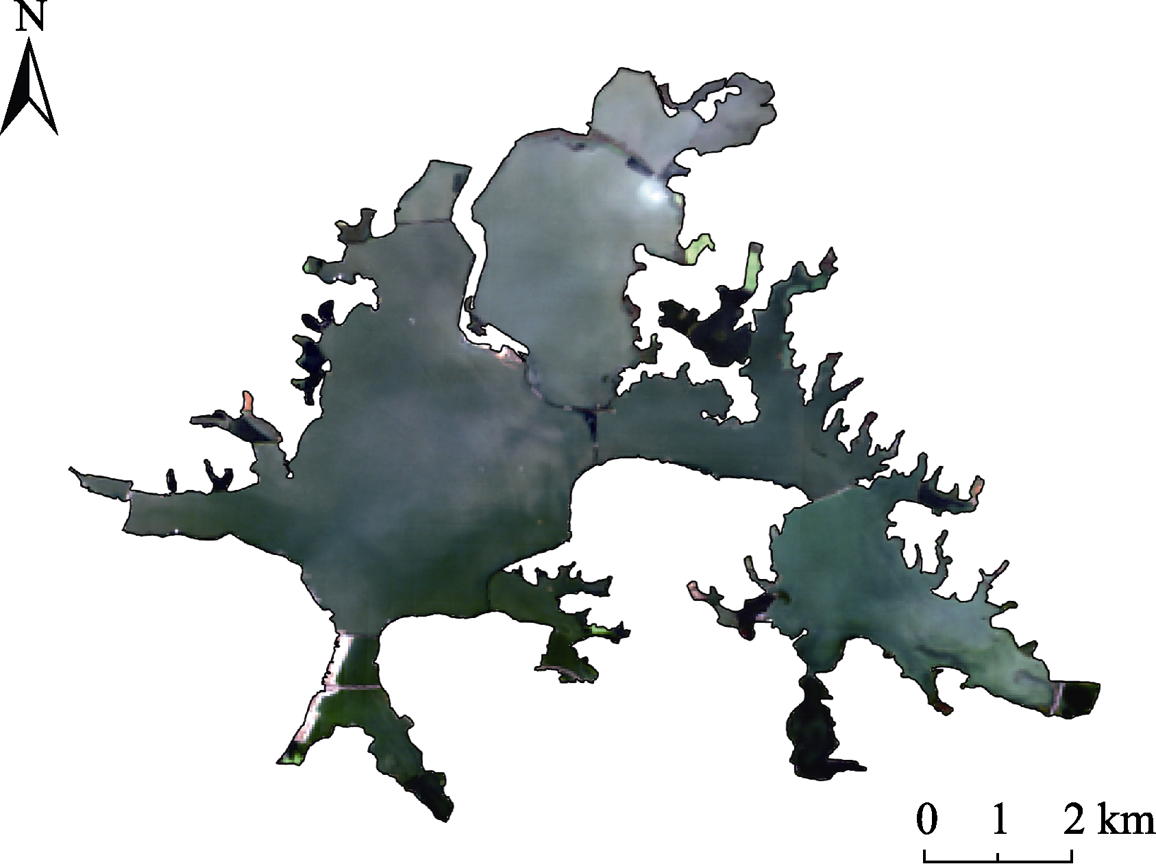
图4 武汉东湖Landsat影像图(2020年10月22日)。
Fig. 4 Landsat image of Donghu Lake in Wuhan (October 22, 2020).
| 分类结果 Classification result | |||||
|---|---|---|---|---|---|
| 挺水/浮水 植物 Emerged/ floating plant | 沉水植物 Submerged plant | 水 Water | 合计 Combined | 精度 Accuracy (%) | |
| 挺水/浮水植物 Emerged/ floating plant | 33 | 3 | 1 | 40 | 82.50 |
| 沉水植物 Submerged plant | 0 | 22 | 1 | 27 | 81.48 |
| 水 Water | 2 | 0 | 24 | 29 | 82.75 |
| 总体精度 Overall accuracy (%) | 82.29 | ||||
| Kappa系数 Kappa coefficient (%) | 72.39 | ||||
表2 武汉东湖水生植物分类结果(2020年8月)
Table 2 Classification results of aquatic plants of Donghu Lake in Wuhan (August 2020)
| 分类结果 Classification result | |||||
|---|---|---|---|---|---|
| 挺水/浮水 植物 Emerged/ floating plant | 沉水植物 Submerged plant | 水 Water | 合计 Combined | 精度 Accuracy (%) | |
| 挺水/浮水植物 Emerged/ floating plant | 33 | 3 | 1 | 40 | 82.50 |
| 沉水植物 Submerged plant | 0 | 22 | 1 | 27 | 81.48 |
| 水 Water | 2 | 0 | 24 | 29 | 82.75 |
| 总体精度 Overall accuracy (%) | 82.29 | ||||
| Kappa系数 Kappa coefficient (%) | 72.39 | ||||
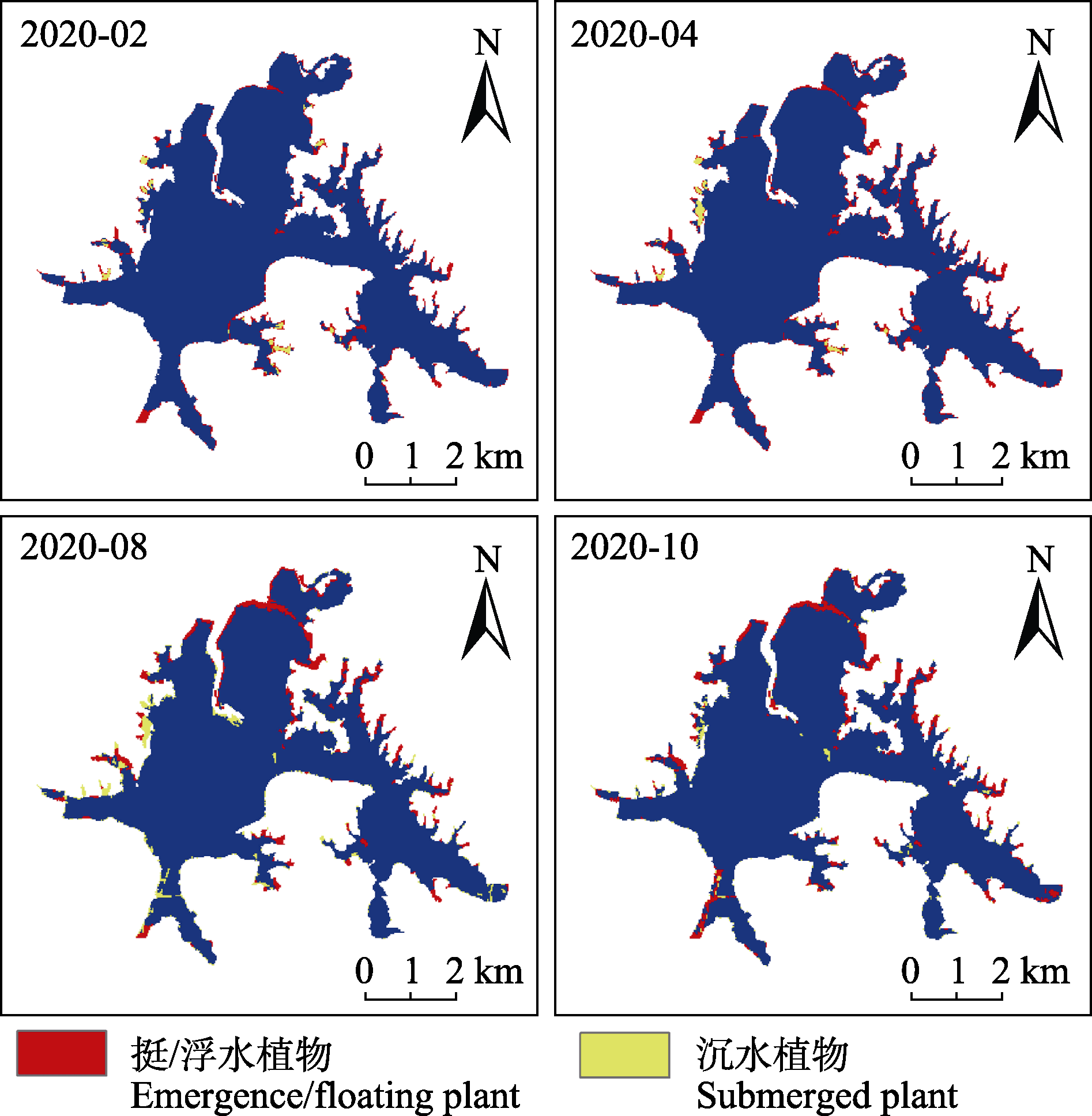
图5 武汉东湖水生植物分布图。
Fig. 5 Distribution of aquatic plants in Donghu Lake in Wuhan.
| 月份 Month | 挺水/浮水植物 Emergence/floating plant (km2) | 沉水植物 Submerged plant (km2) |
|---|---|---|
| 2 | 1.43 | 0.23 |
| 4 | 2.07 | 0.36 |
| 8 | 3.36 | 0.44 |
| 10 | 3.13 | 0.38 |
表3 2020年武汉东湖水生植物面积统计
Table 3 Area of aquatic plants in Donghu Lake in Wuhan in 2020
| 月份 Month | 挺水/浮水植物 Emergence/floating plant (km2) | 沉水植物 Submerged plant (km2) |
|---|---|---|
| 2 | 1.43 | 0.23 |
| 4 | 2.07 | 0.36 |
| 8 | 3.36 | 0.44 |
| 10 | 3.13 | 0.38 |
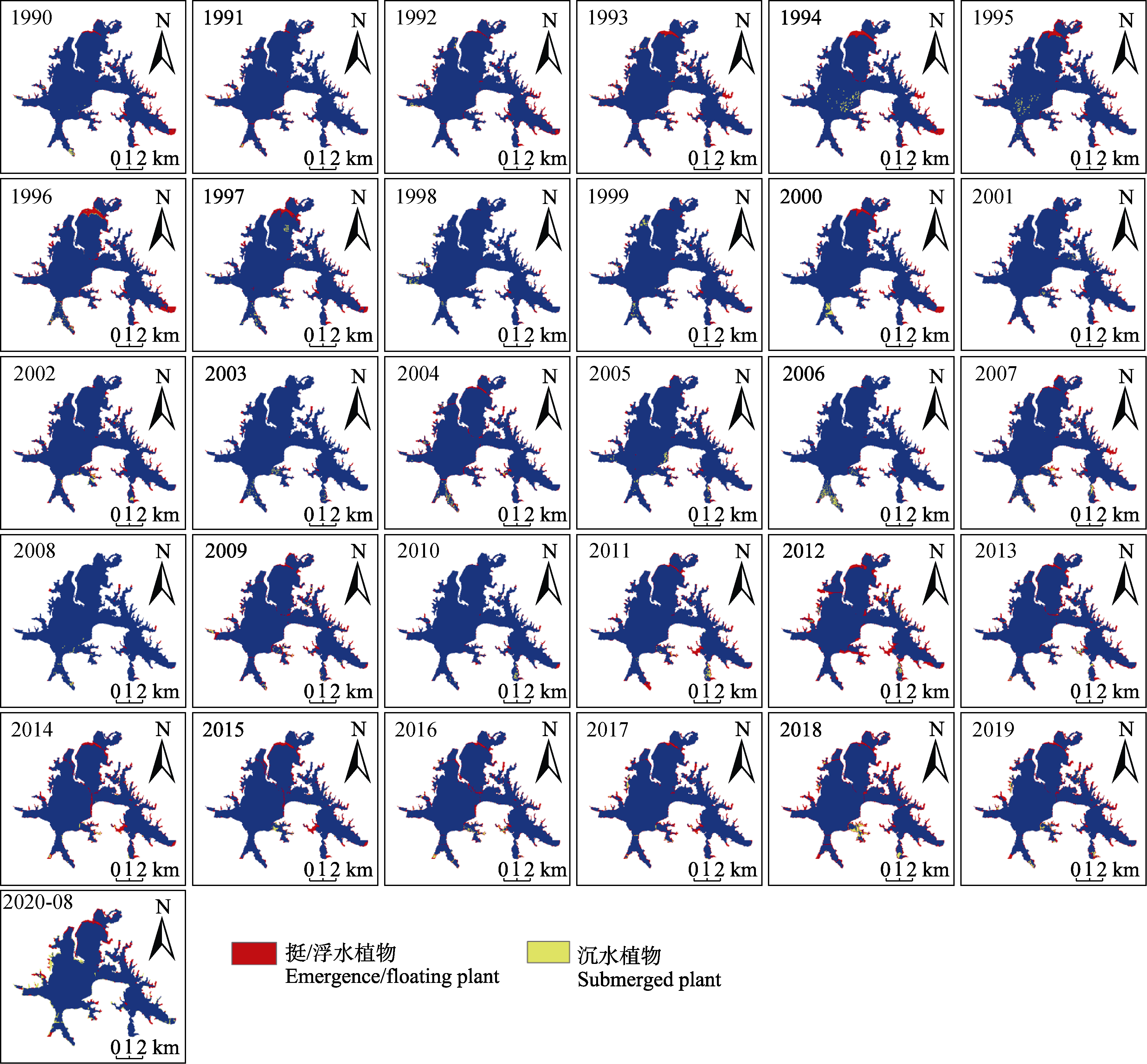
图6 1990-2020年武汉东湖水生植物分布图。
Fig. 6 Spatial distribution maps of aquatic vegetations in the Donghu Lake of Wuhan during 1990-2020.
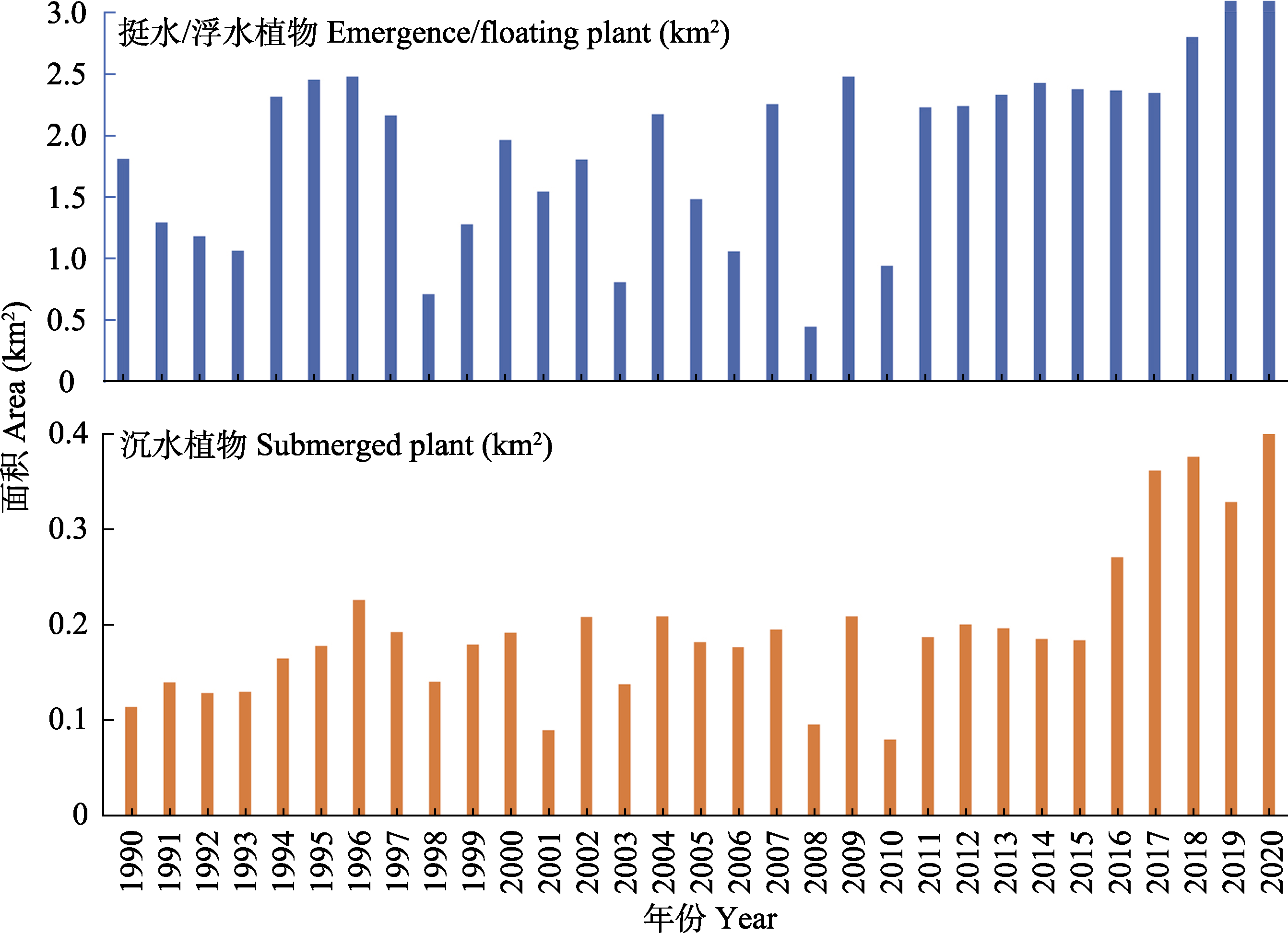
图7 1990-2020年武汉东湖水生植物面积统计。
Fig. 7 Area of aquatic plants in Donghu Lake of Wuhan during 1990-2020.
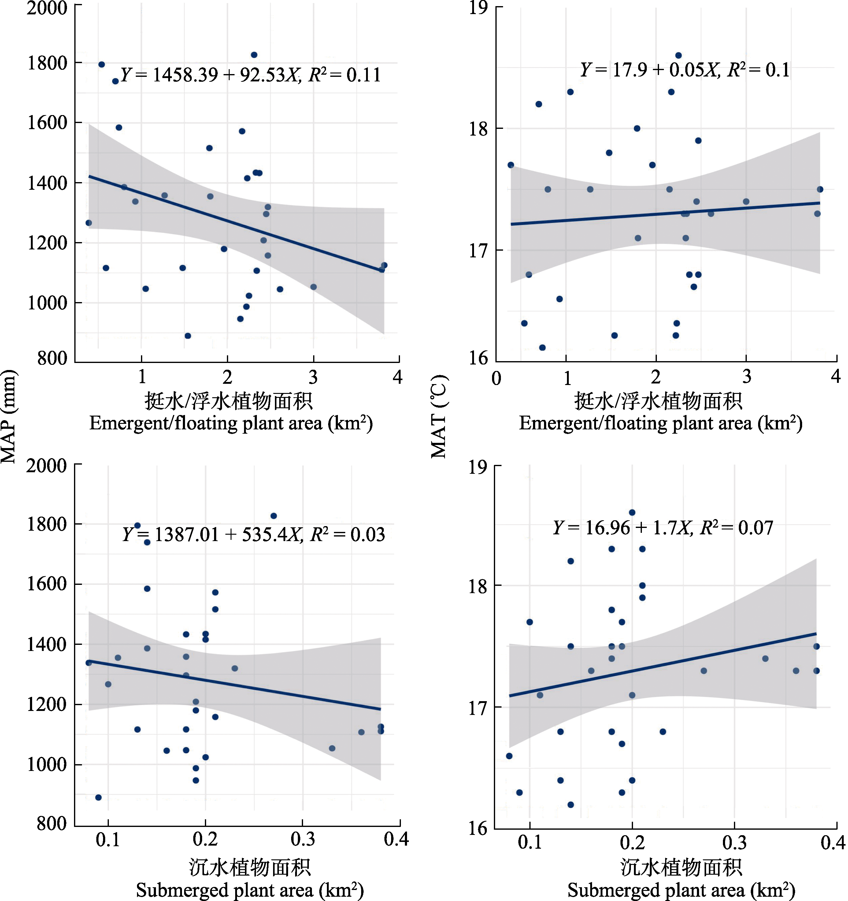
图8 年平均气温(MAT)和年降水量(MAP)与武汉东湖水生植物相关性。
Fig. 8 Correlation of mean annual air temperature (MAT) and mean annual precipitation (MAP) with in Donghu Lake of Wuhan aquatic plants.
| 环境指标 Environmental indicator | 有水生植物分布的样点(25个) Sample points with aquatic plant distribution | 无水生植物分布的样点(50个) Sample points without aquatic plant distribution | ||
|---|---|---|---|---|
| 范围 Scope | 平均值 Mean | 范围 Scope | 平均值 Mean | |
| 总氮含量 Total nitrogen content (mg·L-1) | 0.56-4.56 | 1.56 | 0.62-6.65 | 1.86 |
| 总磷含量 Total phosphorous content (mg·L-1) | 0.04-0.30 | 0.12 | 0.04-0.37 | 0.14 |
| 水深 Water depth (m) | 0.80-3.20 | 2.58 | 0.70-4.40 | 3.29 |
| 透明度 Transparency (m) | 0.55-1.39 | 0.92 | 0.36-1.35 | 0.83 |
| 温度 Temperature (℃) | 10.96-17.64 | 14.73 | 9.97-17.38 | 14.74 |
| pH | 7.96-9.44 | 8.65 | 7.86-9.24 | 8.69 |
| 浊度 Turbidity (g·L-1) | 4.30-41.80 | 15.15 | 3.40-49.40 | 15.98 |
| 溶解性总固体含量 Total dissolved solids content (g·L-1) | 0.23-0.31 | 0.27 | 0.23-0.33 | 0.27 |
表4 武汉东湖有无水生植物的环境因子的差异
Table 4 Differences in environmental factors with or without aquatic plants of Donghu Lake in Wuhan
| 环境指标 Environmental indicator | 有水生植物分布的样点(25个) Sample points with aquatic plant distribution | 无水生植物分布的样点(50个) Sample points without aquatic plant distribution | ||
|---|---|---|---|---|
| 范围 Scope | 平均值 Mean | 范围 Scope | 平均值 Mean | |
| 总氮含量 Total nitrogen content (mg·L-1) | 0.56-4.56 | 1.56 | 0.62-6.65 | 1.86 |
| 总磷含量 Total phosphorous content (mg·L-1) | 0.04-0.30 | 0.12 | 0.04-0.37 | 0.14 |
| 水深 Water depth (m) | 0.80-3.20 | 2.58 | 0.70-4.40 | 3.29 |
| 透明度 Transparency (m) | 0.55-1.39 | 0.92 | 0.36-1.35 | 0.83 |
| 温度 Temperature (℃) | 10.96-17.64 | 14.73 | 9.97-17.38 | 14.74 |
| pH | 7.96-9.44 | 8.65 | 7.86-9.24 | 8.69 |
| 浊度 Turbidity (g·L-1) | 4.30-41.80 | 15.15 | 3.40-49.40 | 15.98 |
| 溶解性总固体含量 Total dissolved solids content (g·L-1) | 0.23-0.31 | 0.27 | 0.23-0.33 | 0.27 |
| [1] |
Barko JW, Gunnison D, Carpenter SR (1991). Sediment interactions with submersed macrophyte growth and community dynamics. Aquatic Botany, 41, 41-65.
DOI URL |
| [2] |
Cao M, Qing S, Jin E, Hao Y, Zhao W (2021). A spectral index for the detection of algal blooms using Sentinel-2 Multispectral Instrument (MSI) imagery: a case study of Hulun Lake, China. International Journal of Remote Sensing, 42, 4514-4535.
DOI URL |
| [3] | Chen L, Lin H (2014). Vegetation information extraction based on K-T transform and principal component transform. Journal of Central South University of Forestry & Technology, 34(6), 81-84. |
| [ 陈利, 林辉 (2014). 基于K-T变换和主成分变换的植被信息提取. 中南林业科技大学学报, 34(6), 81-84.] | |
| [4] |
Christy EJ, Sharitz RR (1980). Characteristics of three populations of a swamp annual under different temperature regimes. Ecology, 61, 454-460.
DOI URL |
| [5] |
Datta A, Maharaj S, Prabhu GN, Bhowmik D, Marino A, Akbari V, Rupavatharam S, Sujeetha JARP, Anantrao GG, Poduvattil VK, Kumar S, Kleczkowski A (2021). Monitoring the spread of water hyacinth (Pontederia crassipes): challenges and future developments. Frontiers in Ecology and Evolution, 9, 631338. DOI: 10.3389/fevo.2021.631338.
DOI URL |
| [6] | Fang X, Zhao FB, Chai XL, Wang LQ (2021). Relationship between the distribution of submerged plants and water environment factors in Yilong Lake. Resources and Environment in the Yangtze Basin, 30, 636-643. |
| [ 方馨, 赵风斌, 柴晓利, 王丽卿 (2021). 异龙湖沉水植物分布格局与水环境因子相关性研究. 长江流域资源与环境, 30, 636-643.] | |
| [7] |
Guo KD, Zhang XB, Liu PZ, Lei GC, Lv S, Zeng XF, Zeng WK (2020). The response of submerged plants to different environmental factors and hydrologic regime in West Lake Dongting. Journal of Lake Sciences, 32, 1736-1748.
DOI URL |
| [ 郭凯迪, 张晓波, 刘培中, 雷光春, 吕偲, 曾喜凡, 曾伟坤 (2020). 西洞庭湖沉水植物分布格局对环境因子及水文情势差异的响应. 湖泊科学, 32, 1736-1748.] | |
| [8] |
Kong JX, Zhang ZC, Zhang J (2019). Classification and identification of plant species based on multi-source remote sensing data: research progress and prospect. Biodiversity Science, 27, 796-812.
DOI |
|
[ 孔嘉鑫, 张昭臣, 张健 (2019). 基于多源遥感数据的植物物种分类与识别: 研究进展与展望. 生物多样性, 27, 796-812.]
DOI |
|
| [9] | Li D, Zhang L (2003). Influence of environmental deterioration of inland natural waters on aquatic organisms in China. Reservoir Fisheries, 23(6), 36-37. |
| [ 李达, 张力 (2003). 我国内陆天然水域的环境恶化对水生生物的影响. 水利渔业, 23(6), 36-37.] | |
| [10] |
Li XJ, Huang MT, Wang RH (2020). Numerical simulation of Donghu Lake hydrodynamics and water quality based on remote sensing and MIKE 21. ISPRS International Journal of Geo-Information, 9, 94. DOI: 10.3390/ijgi9020094.
DOI URL |
| [11] | Liang S, An QR, Wang J (2012). Study on hyperspectral remote sensing inversion model of chlorophyll a and suspended matter concentration in east lake of Wuhan. Science and Technology Innovation Herald, (28), 29-30. |
| [ 梁思, 安巧绒, 王佳 (2012). 武汉东湖叶绿素a和悬浮物浓度的高光谱遥感反演模型研究. 科技创新导报, (28), 29-30.] | |
| [12] |
Liu XH, Zhang YL, Shi K, Zhou YQ, Tang XM, Zhu GW, Qin BQ (2015). Mapping aquatic vegetation in a large, shallow eutrophic lake: a frequency-based approach using multiple years of MODIS data. Remote Sensing, 7, 10295-10320.
DOI URL |
| [13] |
Luo JH, Li XC, Ma RH, Li F, Duan HT, Hu WP, Qin BQ, Huang WJ (2016). Applying remote sensing techniques to monitoring seasonal and interannual changes of aquatic vegetation in Taihu Lake, China. Ecological Indicators, 60, 503-513.
DOI URL |
| [14] | Luo KX, Tao FL (2017). Method for wetland type extraction using remote sensing combing object-oriented and tasseled cap transformation. Transactions of the Chinese Society of Agricultural Engineering, 33, 198-203. |
| [ 罗开盛, 陶福禄 (2017). 融合面向对象与缨帽变换的湿地覆被类别遥感提取方法. 农业工程学报, 33, 198-203.] | |
| [15] |
Oyama Y, Matsushita B, Fukushima T (2015). Distinguishing surface cyanobacterial blooms and aquatic macrophytes using Landsat/TM and ETM+ shortwave infrared bands. Remote Sensing of Environment, 157, 35-47.
DOI URL |
| [16] |
Patel M, Jernigan S, Richardson R, Ferguson S, Buckner G (2019). Autonomous robotics for identification and management of invasive aquatic plant species. Applied Sciences, 9, 2410. DOI: 10.3390/app9122410.
DOI URL |
| [17] |
Pearson RM, Collier CJ, Brown CJ, Rasheed MA, Bourner J, Turschwell MP, Sievers M, Connolly RM (2021). Remote estimation of aquatic light environments using machine learning: a new management tool for submerged aquatic vegetation. Science of the Total Environment, 782, 146886. DOI: 10.1016/j.scitotenv.2021.146886.
DOI URL |
| [18] | Peng AL, Gu Z, Huang JB, Zhang Q, Ni T, Tao SJ (2021). A case study of impact of aquatic plants on pond water quality. Pearl River, 42(3), 81-86. |
| [ 彭爱凌, 顾准, 黄金柏, 张钦, 倪韬, 陶驷骥 (2021). 水生植物对水塘水质影响的实例研究. 人民珠江, 42(3), 81-86.] | |
| [19] |
Phillips G, Willby N, Moss B (2016). Submerged macrophyte decline in shallow lakes: What have we learnt in the last forty years? Aquatic Botany, 135, 37-45.
DOI URL |
| [20] |
Qing S, A R, Shun B, Zhao W, Bao Y, Hao Y (2020). Distinguishing and mapping of aquatic vegetations and yellow algae bloom with Landsat satellite data in a complex shallow Lake, China during 1986-2018. Ecological Indicators, 112, 106073. DOI: 10.1016/j.ecolind.2020.106073.
DOI URL |
| [21] | Sachse R, Petzoldt T, Blumstock M, Moreira S, Pätzig M, Rücker J, Janse JH, Mooij WM, Hilt S (2014). Extending one-dimensional models for deep lakes to simulate the impact of submerged macrophytes on water quality. Environmental Modelling & Software, 61, 410-423. |
| [22] | Wang B, Zhou LP, Li W (2002). Preliminary studies on the purifying function and its physiological reaction of Potamageton crispus under different water qualities. Journal of Wuhan Botanical Research, 20, 150-152. |
| [ 王斌, 周莉苹, 李伟 (2002). 不同水质条件下菹草的净化作用及其生理反应初步研究. 武汉植物学研究, 20, 150-152.] | |
| [23] | Wang SH, Li JL, Jiang X, Wang WW, Zhang B, Zhao L (2015). Division of submerged aquatic vegetation restoration region in Lihu Lake based on light compensation depth. Research of Environmental Sciences, 28, 1389-1396. |
| [ 王书航, 李佳璐, 姜霞, 王雯雯, 张博, 赵丽 (2015). 基于光补偿深度的蠡湖沉水植物恢复区划分. 环境科学研究, 28, 1389-1396.] | |
| [24] | Wu ZB, Chen DQ, Qiu DR, Liu BY (2003). Investigation of the distribution of the aquatic vegetation in Lake Donghu, Wuhan. Chongqing Environmental Science, 25(8), 54-58. |
| [ 吴振斌, 陈德强, 邱东茹, 刘保元 (2003). 武汉东湖水生植被现状调查及群落演替分析. 重庆环境科学, 25(8), 54-58.] | |
| [25] | Yan GA, Ma JM, Qiu DR, Wu ZB (1997). Succession and species replacement of aquatic plant community in East Lake. Acta Phytoecologica Sinica, 21, 319-327. |
| [ 严国安, 马剑敏, 邱东茹, 吴振斌 (1997). 武汉东湖水生植物群落演替的研究. 植物生态学报, 21, 319-327.] | |
| [26] | Yan GA, Ren N, Ma JM, Tan ZQ, Li YJ (1995). Study on aquatic vegetation and its restoration in East Lake, Wuhan. Journal of Plant Resources and Environment, 4(3), 21-27. |
| [ 严国安, 任南, 马剑敏, 谭智群, 李益健 (1995). 武汉东湖水生植被及其恢复途径探讨. 植物资源与环境, 4(3), 21-27.] | |
| [27] | Yao ZW, Li YJ, Xia SL (1990). Studies of the aquatic vascular plants and eutrophication in Wuhan East Lake. Chongqing Environmental Science, 12(4), 26-30. |
| [ 姚作五, 李益健, 夏盛林 (1990). 武汉东湖水维管束植物与富营养化. 重庆环境科学, 12(4), 26-30.] | |
| [28] |
Yu Q, Mickler RA, Liu Y, Sun L, Zhou L, Zhang B, Deng H, Liang L (2020). Remote sensing of Potamogeton crispus L. in Dongping Lake in the north China plain based on vegetation phenology. Journal of the Indian Society of Remote Sensing, 48, 563-573.
DOI |
| [29] |
Zhang YL, Jeppesen E, Liu XH, Qin BQ, Shi K, Zhou YQ, Thomaz SM, Deng JM (2017). Global loss of aquatic vegetation in lakes. Earth-Science Reviews, 173, 259-265.
DOI URL |
| [30] | Zhong AW, Song X, Zhang J, He L, Yi CL, Ni LY, Cao T (2017). Diversity and distribution of aquatic plants in Lake Donghu in Wuhan in 2014. Research of Environmental Sciences, 30, 398-405. |
| [ 钟爱文, 宋鑫, 张静, 何亮, 易春龙, 倪乐意, 曹特 (2017). 2014年武汉东湖水生植物多样性及其分布特征. 环境科学研究, 30, 398-405.] | |
| [31] | Zou LS, Nie ZY, Yao XY, Shi JY (2013). Effects of light on submerged macrophytes in eutrophic water: research progress. Chinese Journal of Applied Ecology, 24, 2073-2080. |
| [ 邹丽莎, 聂泽宇, 姚笑颜, 施积炎 (2013). 富营养化水体中光照对沉水植物的影响研究进展. 应用生态学报, 24, 2073-2080.] |
| [1] | 段俊丞, 王志勇, 高维聪, 张成凯, 高长宏, 刘晓彤, 李振今. 黄河三角洲湿地入侵物种互花米草时空演化与景观格局分析[J]. 植物生态学报, 2025, 49(6): 922-938. |
| [2] | 郑亚纹, 樊海东, 刘立斌, 倪健. 基于高精度遥感影像和精细植被踏查的金华北山植被制图[J]. 植物生态学报, 2024, 48(11): 1471-1485. |
| [3] | 郝晴, 黄昌. 森林地上生物量遥感估算研究综述[J]. 植物生态学报, 2023, 47(10): 1356-1374. |
| [4] | 丛楠, 张扬建, 朱军涛. 北半球中高纬度地区近30年植被春季物候温度敏感性[J]. 植物生态学报, 2022, 46(2): 125-135. |
| [5] | 田佳玉, 王彬, 张志明, 林露湘. 光谱多样性在植物多样性监测与评估中的应用[J]. 植物生态学报, 2022, 46(10): 1129-1150. |
| [6] | 严正兵, 刘树文, 吴锦. 高光谱遥感技术在植物功能性状监测中的应用与展望[J]. 植物生态学报, 2022, 46(10): 1151-1166. |
| [7] | 陈哲, 汪浩, 王金洲, 石慧瑾, 刘慧颖, 贺金生. 基于物候相机归一化植被指数估算高寒草地植物地上生物量的季节动态[J]. 植物生态学报, 2021, 45(5): 487-495. |
| [8] | 欧文慧, 刘亚恒, 李娜, 徐芷妍, 彭秋桐, 杨予静, 李中强. 柴达木盆地水生植物多样性格局及多假说验证[J]. 植物生态学报, 2021, 45(11): 1213-1220. |
| [9] | 郭庆华, 胡天宇, 马勤, 徐可心, 杨秋丽, 孙千惠, 李玉美, 苏艳军. 新一代遥感技术助力生态系统生态学研究[J]. 植物生态学报, 2020, 44(4): 418-435. |
| [10] | 张富广, 曾彪, 杨太保. 气候变化背景下近30年祁连山高寒荒漠分布时空变化[J]. 植物生态学报, 2019, 43(4): 305-319. |
| [11] | 张峰,周广胜. 植被含水量高光谱遥感监测研究进展[J]. 植物生态学报, 2018, 42(5): 517-525. |
| [12] | 王克清, 王鹤松, 孙建新. 遥感GPP模型在中国地区多站点的应用与比较[J]. 植物生态学报, 2017, 41(3): 337-347. |
| [13] | 汪洋, 苗琳琳, 于丹, 刘春花, 王忠. 青藏高原3种生活型水生植物的热值及环境的影响[J]. 植物生态学报, 2017, 41(2): 209-218. |
| [14] | 高林, 王晓菲, 顾行发, 田庆久, 焦俊男, 王培燕, 李丹. 植冠下土壤类型差异对遥感估算冬小麦叶面积指数的影响[J]. 植物生态学报, 2017, 41(12): 1273-1288. |
| [15] | 窦渤凯, 王义东, 薛冬梅, 王中良. 挺水和湿生草本植物传输甲烷的过程与机制研究进展[J]. 植物生态学报, 2017, 41(11): 1208-1218. |
| 阅读次数 | ||||||
|
全文 |
|
|||||
|
摘要 |
|
|||||
Copyright © 2026 版权所有 《植物生态学报》编辑部
地址: 北京香山南辛村20号, 邮编: 100093
Tel.: 010-62836134, 62836138; Fax: 010-82599431; E-mail: apes@ibcas.ac.cn, cjpe@ibcas.ac.cn
备案号: 京ICP备16067583号-19
![]()