
植物生态学报 ›› 2023, Vol. 47 ›› Issue (10): 1356-1374.DOI: 10.17521/cjpe.2023.0008 cstr: 32100.14.cjpe.2023.0008
郝晴1, 黄昌1,2,*( )
)
收稿日期:2023-01-11
接受日期:2023-05-30
出版日期:2023-10-20
发布日期:2023-11-23
HAO Qing1, HUANG Chang1,2,*()
Received:2023-01-11
Accepted:2023-05-30
Online:2023-10-20
Published:2023-11-23
摘要:
森林是重要的陆地生态系统, 分布广、生物总量大, 在全球碳循环中起着重要作用。森林地上生物量(AGB)是森林生态系统生产力的重要指标, 也是碳循环的重要参数, 森林AGB的精确估算对研究生态系统的物质循环和全球气候变化具有重要意义。传统的森林AGB估算方法需要获取单木尺度或者林分尺度的物理结构信息, 较为耗时、耗力, 而遥感技术因其可以获得全方位、多时相、大范围的森林结构信息, 在森林AGB估算中发挥着不可替代的作用。因此, 有必要对近年来遥感技术估算森林AGB领域所取得的进展进行归纳、总结和展望, 以期进一步促进遥感数据和方法在该领域的应用以及有效指导相关行业的发展。该文系统归纳了光学数据、合成孔径雷达(SAR)数据与激光雷达(LiDAR)数据估算森林AGB的原理及方法, 并对多源遥感数据协同估算森林AGB的研究现状进行了梳理, 总结了如下结论: 1)新型遥感数据(如高分系列卫星、全球生态系统动态监测激光雷达等)在生物量估算领域的应用愈加广泛, 在时空分辨率方面不断突破, 进一步丰富了森林AGB研究的数据来源; 2)多源遥感数据协同方式能更好地提高森林AGB估算的精度, 但相关模型仍需进行更深层次的优化; 3)目前机器学习、人工智能、深度学习已广泛应用于森林AGB的估算, 但是遥感机理的研究是创新的根源, 模型或方法的改进仍需围绕遥感机理展开。
郝晴, 黄昌. 森林地上生物量遥感估算研究综述. 植物生态学报, 2023, 47(10): 1356-1374. DOI: 10.17521/cjpe.2023.0008
HAO Qing, HUANG Chang. A review of forest aboveground biomass estimation based on remote sensing data. Chinese Journal of Plant Ecology, 2023, 47(10): 1356-1374. DOI: 10.17521/cjpe.2023.0008
| 植被指数 Vegetation index | 计算公式 Calculation formula | 特点 Characteristic |
|---|---|---|
| 归一化植被指数 Normalized differential vegetation index (NDVI) | NDVI = (NIR - Red)/(NIR + Red) | 应用广泛、反映植被空间分布与生长状况 It is widely used and reflects the spatial distribution and growth of vegetation |
| 增强型植被指数 Enhanced vegetation index (EVI) | EVI = 2.5 × (NIR - Red)/(NIR + 6Red - 7.5Blue + 1) | 可纠正大气和土壤背景的影响, 不易饱和 It can correct the influence of atmospheric and soil background and is not easily saturated |
| 比值植被指数 Ratio vegetation index (RVI) | RVI = NIR/Red | 计算简单, 在植被密集区域灵敏度高 It’s easy to calculate and has high sensitivity in densely vegetated areas |
| 差值植被指数 Differential vegetation index (DVI) | DVI = NIR - Red | 对土壤背景变化敏感, 易区分土壤和植被 It’s sensitive to soil background changes and easy to distinguish between soil and vegetation |
| 重归一化植被指数 Re-normalized differential vegetation index (RDVI) | RDVI = (NIR – Red)/ | 可区分土壤和植被, 也可以反映植被信息 It can distinguish between soil and vegetation and reflect vegetation information |
| 土壤调节植被指数 Soil-adjusted vegetation index (SAVI) | SAVI = 1.5 × (NIR - Red)/(NIR + Red + 0.5) | 考虑土壤光学性质, 适用于稀疏植被区域 It can take into account soil optical properties and is suitable for areas of sparse vegetation |
| 修正土壤调节植被指数 Modified soil-adjusted vegetation index (MSAVI) | MSAVI = 1/2 × (2NIR + 1 – | 可消除土壤背景 It can remove the soil background |
| 垂直植被指数 Perpendicular vegetation index (PVI) | PVI = (NIR – 0.791Red – 0.043)/ | 用于地表植被参数的反演 It can be used for inversion of surface vegetation parameters |
表1 部分常用植被指数及其特点
Table 1 Several popular vegetation indices and their characteristics
| 植被指数 Vegetation index | 计算公式 Calculation formula | 特点 Characteristic |
|---|---|---|
| 归一化植被指数 Normalized differential vegetation index (NDVI) | NDVI = (NIR - Red)/(NIR + Red) | 应用广泛、反映植被空间分布与生长状况 It is widely used and reflects the spatial distribution and growth of vegetation |
| 增强型植被指数 Enhanced vegetation index (EVI) | EVI = 2.5 × (NIR - Red)/(NIR + 6Red - 7.5Blue + 1) | 可纠正大气和土壤背景的影响, 不易饱和 It can correct the influence of atmospheric and soil background and is not easily saturated |
| 比值植被指数 Ratio vegetation index (RVI) | RVI = NIR/Red | 计算简单, 在植被密集区域灵敏度高 It’s easy to calculate and has high sensitivity in densely vegetated areas |
| 差值植被指数 Differential vegetation index (DVI) | DVI = NIR - Red | 对土壤背景变化敏感, 易区分土壤和植被 It’s sensitive to soil background changes and easy to distinguish between soil and vegetation |
| 重归一化植被指数 Re-normalized differential vegetation index (RDVI) | RDVI = (NIR – Red)/ | 可区分土壤和植被, 也可以反映植被信息 It can distinguish between soil and vegetation and reflect vegetation information |
| 土壤调节植被指数 Soil-adjusted vegetation index (SAVI) | SAVI = 1.5 × (NIR - Red)/(NIR + Red + 0.5) | 考虑土壤光学性质, 适用于稀疏植被区域 It can take into account soil optical properties and is suitable for areas of sparse vegetation |
| 修正土壤调节植被指数 Modified soil-adjusted vegetation index (MSAVI) | MSAVI = 1/2 × (2NIR + 1 – | 可消除土壤背景 It can remove the soil background |
| 垂直植被指数 Perpendicular vegetation index (PVI) | PVI = (NIR – 0.791Red – 0.043)/ | 用于地表植被参数的反演 It can be used for inversion of surface vegetation parameters |
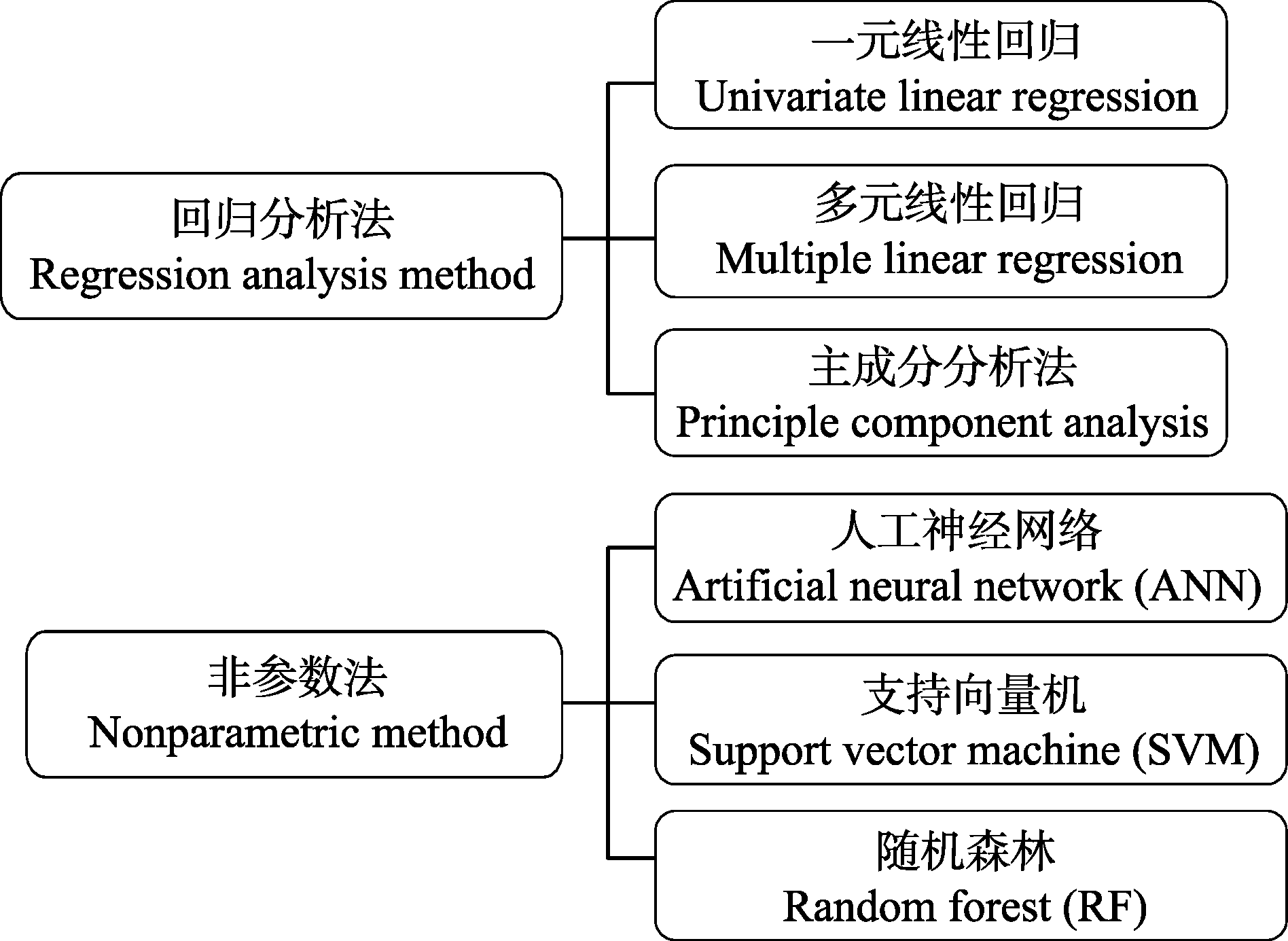
图1 光学遥感估算地上生物量的方法。
Fig. 1 Methods for estimating aboveground biomass by optical remote sensing.
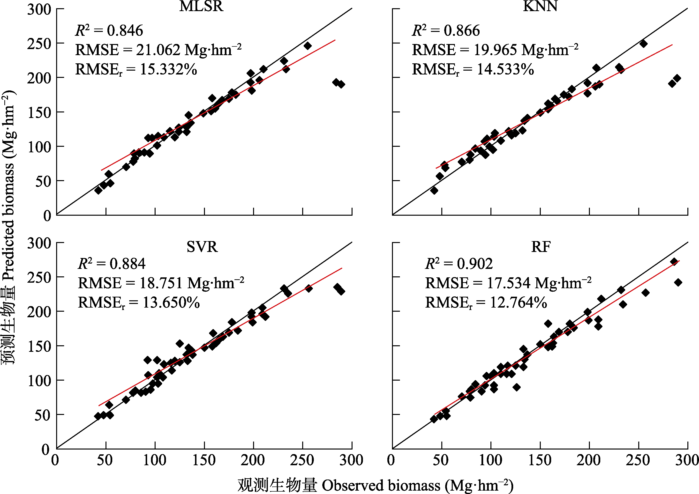
图2 不同机器学习模型——多元逐步线性回归(MLSR)、K最近邻算法(KNN)、支持向量回归(SVR)和随机森林(RF)算法预测地上生物量的性能对比(据Zhang等(2019a)修改)。R2, 决定系数; RMSE, 均方根误差; RMSEr, 相对均方根误差。
Fig. 2 Performance of aboveground biomass estimation with different machine learning models: multiple stepwise linear regression (MLSR), K-nearest neighbor (KNN), support vector regression (SVR), and random forest (RF) (modified from Zhang et al. (2019a)). R2, coefficient of determination; RMSE, root mean squared error; RMSEr, relative root mean squared error.
| 国家或机构 Country or agency | 卫星名称 Satellite name | 年份 Year | 极化方式 Polarization mode |
|---|---|---|---|
| 中国 China | HJ-1 | 2012 | VV (S波段) VV (S band) |
| GF-3 | 2016 | 可选单极化(C波段) Optional unipolarization (C band) | |
| Qilu-1 | 2021 | Ku谱段 Ku band | |
| 海丝一号 Hisea-1 | 2022 | VV (C波段) VV (C band) | |
| LT-1A | 2022 | 全极化(L波段) Full polarization (L band) | |
| LT-1B | 2022 | 全极化(L波段) Full polarization (L band) | |
| 巢湖一号 Chaohu-1 | 2022 | (C波段) (C band) | |
| 美国 USA | Seasat-A | 1978 | HH (L波段) HH (L band) |
| Capalla-1 | 2018 | HH (X波段) HH (X band) | |
| Capalla-2 | 2020 | HH (X波段) HH (X band) | |
| Capalla-3 | 2021 | HH (X波段) HH (X band) | |
| Capalla-4 | 2021 | HH (X波段) HH (X band) | |
| 欧洲航天局 European Space Agency (ESA) | ENVISAT | 2002 | 双极化(C波段) Bipolarization (C band) |
| Sentinel-1A | 2014 | 双极化(C波段) Bipolarization (C band) | |
| Sentinel-1B | 2016 | 双极化(C波段) Bipolarization (C band) | |
| 加拿大 Canada | RADARSAT-2 | 2006 | 全极化(L、C波段) Full polarization (L, C band) |
| 德国宇航局 Deutsches Zentrum für Luft- und Raumfahrt (DLR) | TerraSAR-X | 2007 | 单极化、双极化、全极化(X波段) Unipolarization, bipolarization, full polarization (X band) |
| TanDEM-X | 2010 | 单极化、双极化、全极化(X波段) Unipolarization, bipolarization, full polarization (X band) | |
| 日本 Japan | ALOS-PALSAR1 | 2006 | 全极化(L、C波段) Full polarization (L, C band) |
| ALOS2-PALSAR2 | 2014 | 全极化(L、C波段) Full polarization (L, C band) |
表2 常用于生物量估算的合成孔径雷达卫星
Table 2 Synthetic aperture radar satellites commonly used for biomass estimation
| 国家或机构 Country or agency | 卫星名称 Satellite name | 年份 Year | 极化方式 Polarization mode |
|---|---|---|---|
| 中国 China | HJ-1 | 2012 | VV (S波段) VV (S band) |
| GF-3 | 2016 | 可选单极化(C波段) Optional unipolarization (C band) | |
| Qilu-1 | 2021 | Ku谱段 Ku band | |
| 海丝一号 Hisea-1 | 2022 | VV (C波段) VV (C band) | |
| LT-1A | 2022 | 全极化(L波段) Full polarization (L band) | |
| LT-1B | 2022 | 全极化(L波段) Full polarization (L band) | |
| 巢湖一号 Chaohu-1 | 2022 | (C波段) (C band) | |
| 美国 USA | Seasat-A | 1978 | HH (L波段) HH (L band) |
| Capalla-1 | 2018 | HH (X波段) HH (X band) | |
| Capalla-2 | 2020 | HH (X波段) HH (X band) | |
| Capalla-3 | 2021 | HH (X波段) HH (X band) | |
| Capalla-4 | 2021 | HH (X波段) HH (X band) | |
| 欧洲航天局 European Space Agency (ESA) | ENVISAT | 2002 | 双极化(C波段) Bipolarization (C band) |
| Sentinel-1A | 2014 | 双极化(C波段) Bipolarization (C band) | |
| Sentinel-1B | 2016 | 双极化(C波段) Bipolarization (C band) | |
| 加拿大 Canada | RADARSAT-2 | 2006 | 全极化(L、C波段) Full polarization (L, C band) |
| 德国宇航局 Deutsches Zentrum für Luft- und Raumfahrt (DLR) | TerraSAR-X | 2007 | 单极化、双极化、全极化(X波段) Unipolarization, bipolarization, full polarization (X band) |
| TanDEM-X | 2010 | 单极化、双极化、全极化(X波段) Unipolarization, bipolarization, full polarization (X band) | |
| 日本 Japan | ALOS-PALSAR1 | 2006 | 全极化(L、C波段) Full polarization (L, C band) |
| ALOS2-PALSAR2 | 2014 | 全极化(L、C波段) Full polarization (L, C band) |
| 遥感类型 Sensor type | 优势 Advantage | 不足 Disadvantage |
|---|---|---|
| 光学遥感 Optical remote sensing | 光谱信息丰富, 易得多种时空分辨率影像, 可用于不同尺度的生物量估算研究。数据提取方法较简便, 结果可视化程度较高 Spectral information is abundant, and various spatial and temporal resolution images are easily available, which can be used for biomass estimation research at different scales. The data extraction methods are relatively straightforward, and the results can be visualized to a high degree | 光学传感器易受天气影响, 遥感信号难以到达植被冠层之下, 不能有效反映森林的垂直结构信息, 且受植被密度影响而易导致光饱和现象 Optical sensors are susceptible to weather conditions, and remote sensing signals struggle to penetrate beneath the vegetation canopy, thus failing to effectively capture vertical structural information of forests. Additionally, optical sensors are prone to saturation effects due to variations in vegetation density |
| SAR | 能与树叶、树干和树冠发生作用, 成像受云雨影响小, 可快速获取大区域、全覆盖的影像, 对生物量敏感 SAR can interact with leaves, tree trunks, and canopies, with minimal impact from clouds and rain. It can rapidly acquire large-area, full-coverage images and is highly sensitive to biomass measurements | SAR影像来源相对较少, 数据处理较为复杂, 受地形和土壤条件影响较大, 后向散射系数估算存在饱和性 SAR images have relatively limited data sources and require more complex data processing. They are significantly influenced by terrain and soil conditions. Estimating the backscattering coefficient in SAR images can be subject to saturation effects |
| LiDAR | LiDAR数据的空间分辨率较高, 不仅能够获取森林的垂直结构信息, 而且还克服了信号饱和的局限性 LiDAR data possesses a high spatial resolution, enabling the acquisition of vertical structural information of forests. Moreover, LiDAR data overcomes the limitations of signal saturation | 成本较高, 缺乏历史数据, 具体模型方法受研究区域限制; 机载LiDAR在大尺度空间上采样不连续, 无法达到无缝覆盖, 波形受林下地形和树木空间结构影响较大 LiDAR technology is associated with higher costs and lacks historical data. The specific models and methods may be limited by the research area. Airborne LiDAR suffers from discontinuous sampling at large spatial scales, making it challenging to achieve seamless coverage. The LiDAR waveform is greatly affected by the understory terrain and spatial structure of trees |
表3 使用光学遥感、合成孔径雷达(SAR)和激光雷达(LiDAR)估算生物量对比
Table 3 Biomass estimation comparison using optical remote sensing, synthetic aperture radar (SAR) and light detection and ranging (LiDAR)
| 遥感类型 Sensor type | 优势 Advantage | 不足 Disadvantage |
|---|---|---|
| 光学遥感 Optical remote sensing | 光谱信息丰富, 易得多种时空分辨率影像, 可用于不同尺度的生物量估算研究。数据提取方法较简便, 结果可视化程度较高 Spectral information is abundant, and various spatial and temporal resolution images are easily available, which can be used for biomass estimation research at different scales. The data extraction methods are relatively straightforward, and the results can be visualized to a high degree | 光学传感器易受天气影响, 遥感信号难以到达植被冠层之下, 不能有效反映森林的垂直结构信息, 且受植被密度影响而易导致光饱和现象 Optical sensors are susceptible to weather conditions, and remote sensing signals struggle to penetrate beneath the vegetation canopy, thus failing to effectively capture vertical structural information of forests. Additionally, optical sensors are prone to saturation effects due to variations in vegetation density |
| SAR | 能与树叶、树干和树冠发生作用, 成像受云雨影响小, 可快速获取大区域、全覆盖的影像, 对生物量敏感 SAR can interact with leaves, tree trunks, and canopies, with minimal impact from clouds and rain. It can rapidly acquire large-area, full-coverage images and is highly sensitive to biomass measurements | SAR影像来源相对较少, 数据处理较为复杂, 受地形和土壤条件影响较大, 后向散射系数估算存在饱和性 SAR images have relatively limited data sources and require more complex data processing. They are significantly influenced by terrain and soil conditions. Estimating the backscattering coefficient in SAR images can be subject to saturation effects |
| LiDAR | LiDAR数据的空间分辨率较高, 不仅能够获取森林的垂直结构信息, 而且还克服了信号饱和的局限性 LiDAR data possesses a high spatial resolution, enabling the acquisition of vertical structural information of forests. Moreover, LiDAR data overcomes the limitations of signal saturation | 成本较高, 缺乏历史数据, 具体模型方法受研究区域限制; 机载LiDAR在大尺度空间上采样不连续, 无法达到无缝覆盖, 波形受林下地形和树木空间结构影响较大 LiDAR technology is associated with higher costs and lacks historical data. The specific models and methods may be limited by the research area. Airborne LiDAR suffers from discontinuous sampling at large spatial scales, making it challenging to achieve seamless coverage. The LiDAR waveform is greatly affected by the understory terrain and spatial structure of trees |
| [1] | Abbas S, Wong MS, Wu J, Shahzad N, Muhammad Irteza S(2020). Approaches of satellite remote sensing for the assessment of above-ground biomass across tropical forests: pan-tropical to national scales. Remote Sensing, 12, 3351. DOI: 10.3390/rs12203351. |
| [2] |
Abdalati W, Zwally HJ, Bindschadler R, Csatho B, Farrell SL, Fricker HA, Harding D, Kwok R, Lefsky M, Markus T, Marshak A, Neumann T, Palm S, Schutz B, Smith B, Spinhirne J, Webb C (2010). The ICESat-2 laser altimetry mission. Proceedings of the IEEE, 98, 735-751.
DOI URL |
| [3] |
Ali I, Greifeneder F, Stamenkovic J, Neumann M, Notarnicola C (2015). Review of machine learning approaches for biomass and soil moisture retrievals from remote sensing data. Remote Sensing, 7, 16398-16421.
DOI URL |
| [4] |
Apostol B, Lorent A, Petrila M, Gancz V, Badea O (2016). Height extraction and stand volume estimation based on fusion airborne LiDAR data and terrestrial measurements for a Norway spruce (Picea abies (L.) Karst.) test site in Romania. Notulae Botanicae Horti Agrobotanici Cluj-Napoca, 44, 313-323.
DOI URL |
| [5] | Askne J, Dammert PBG, Smith G (1999). Understanding ERS InSAR coherence of boreal forests. IEEE 1999 International Geoscience and Remote Sensing Symposium, 4, 2111-2114. |
| [6] |
Askne JIH, Dammert PBG, Ulander LMH, Smith G (1997). C-band repeat-pass interferometric SAR observations of the forest. IEEE Transactions on Geoscience and Remote Sensing, 35, 25-35.
DOI URL |
| [7] |
Attema EPW, Ulaby FT (1978). Vegetation modeled as a water cloud. Radio Science, 13, 357-364.
DOI URL |
| [8] |
Bai XJ, He BB, Li XW (2016). Optimum surface roughness to parameterize advanced integral equation model for soil moisture retrieval in prairie area using radarsat-2 data. IEEE Transactions on Geoscience and Remote Sensing, 54, 2437-2449.
DOI URL |
| [9] | Bamler R, Hartl P (1998). Synthetic aperture radar interferometry. Inverse Problems, 14, R1-R54. |
| [10] |
Bargali K, Manral V, Padalia K, Bargali SS, Upadhyay VP (2018). Effect of vegetation type and season on microbial biomass carbon in Central Himalayan forest soils, India. Catena, 171, 125-135.
DOI URL |
| [11] | Bauwens S, Bartholomeus H, Calders K, Lejeune P (2016). Forest inventory with terrestrial LiDAR: a comparison of static and hand-held mobile laser scanning. Forests, 7, 127. DOI: 10.3390/f7060127. |
| [12] |
Bazezew MN, Hussin YA, Kloosterman EH (2018). Integrating airborne LiDAR and terrestrial laser scanner forest parameters for accurate above-ground biomass/carbon estimation in Ayer Hitam tropical forest, Malaysia. International Journal of Applied Earth Observation and Geoinformation, 73, 638-652.
DOI URL |
| [13] |
Bond-Lamberty B, Wang C, Gower ST (2002). Aboveground and belowground biomass and sapwood area allometric equations for six boreal tree species of northern Manitoba. Canadian Journal of Forest Research, 32, 1441-1450.
DOI URL |
| [14] | Brede B, Calders K, Lau A, Raumonen P, Bartholomeus HM, Herold M, Kooistra L (2019). Non-destructive tree volume estimation through quantitative structure modelling: comparing UAV laser scanning with terrestrial LIDAR. Remote Sensing of Environment, 233, 111355. DOI: 10.1016/j.rse.2019.111355. |
| [15] | Breiman L, Friedman JH, Olshen RA, Stone CJ (1984). Classification and Regression Trees. Wadsworth & Brooks, Monterey, USA. |
| [16] | Cao HY, Liu XG, Li SH, Zhang XW (2012). ZY-3 satellite remote sensing technology. Spacecraft Recovery & Remote Sensing, 33(3), 7-16. |
| [曹海翊, 刘希刚, 李少辉, 张新伟 (2012). “资源三号”卫星遥感技术. 航天返回与遥感, 33(3), 7-16.] | |
| [17] | Cao HY, Qiu XY, He T (2022). Review on development of forest biomass remote sensing satellites. Acta Optica Sinica, 42(17), 402-409. |
| [曹海翊, 邱心怡, 贺涛 (2022). 森林生物量遥感卫星发展综述. 光学学报, 42(17), 402-409.] | |
| [18] | Cao HY, Zhang XW, Zhao CG (2020). System design and key technologies of the GF-7 satellite. Chinese Space Science and Technology, 40(5), 1-9. |
| [曹海翊, 张新伟, 赵晨光 (2020). 高分七号卫星总体设计与技术创新. 中国空间科学技术, 40(5), 1-9.] | |
| [19] |
Cartus O, Santoro M, Kellndorfer J (2012). Mapping forest aboveground biomass in the Northeastern United States with ALOS PALSAR dual-polarization L-band. Remote Sensing of Environment, 124, 466-478.
DOI URL |
| [20] |
Cartus O, Santoro M, Schmullius C, Li Z (2011). Large area forest stem volume mapping in the boreal zone using synergy of ERS-1/2 tandem coherence and MODIS vegetation continuous fields. Remote Sensing of Environment, 115, 931-943.
DOI URL |
| [21] |
Castel T, Martinez JM, Beaudoin A, Wegmüller U, Strozzi T (2000). ERS INSAR data for remote sensing hilly forested areas. Remote Sensing of Environment, 73, 73-86.
DOI URL |
| [22] |
Chave J, Andalo C, Brown S, Cairns MA, Chambers JQ, Eamus D, Fölster H, Fromard F, Higuchi N, Kira T, Lescure JP, Nelson BW, Ogawa H, Puig H, Riéra B, Yamakura T (2005). Tree allometry and improved estimation of carbon stocks and balance in tropical forests. Oecologia, 145, 87-99.
DOI PMID |
| [23] | Chen EX (1999). Development of forest biomass estimation using SAR data. World Forestry Research, 12(6), 18-23. |
| [陈尔学 (1999). 合成孔径雷达森林生物量估测研究进展. 世界林业研究, 12(6), 18-23.] | |
| [24] |
Cho MA, Skidmore A, Corsi F, van Wieren SE, Sobhan I (2007). Estimation of green grass/herb biomass from airborne hyperspectral imagery using spectral indices and partial least squares regression. International Journal of Applied Earth Observation and Geoinformation, 9, 414-424.
DOI URL |
| [25] |
Cloude SR (2007). Dual-baseline coherence tomography. IEEE Geoscience and Remote Sensing Letters, 4, 127-131.
DOI URL |
| [26] |
Colomina I, Molina P (2014). Unmanned aerial systems for photogrammetry and remote sensing: a review. ISPRS Journal of Photogrammetry and Remote Sensing, 92, 79-97.
DOI URL |
| [27] | Dong LH, Zhang LJ, Li FR (2016). Developing two additive biomass equations for three coniferous plantation species in northeast China. Forests, 7, 136. DOI: 10.3390/f7070136. |
| [28] | Dong LH, Zhang Y, Zhang Z, Xie LF, Li FR (2020). Comparison of tree biomass modeling approaches for larch (Larix olgensis Henry) trees in northeast China. Forests, 11, 202. DOI: 10.3390/f11020202. |
| [29] |
Du YK, Wang J, Liu ZJ, Yu HY, Li ZH, Cheng H (2019). Evaluation on spaceborne multispectral images, airborne hyperspectral, and LiDAR data for extracting spatial distribution and estimating aboveground biomass of wetland vegetation Suaeda salsa. IEEE Journal of Selected Topics in Applied Earth Observations and Remote Sensing, 12, 200-209.
DOI URL |
| [30] | Ehlers D, Wang C, Coulston J, Zhang YL, Pavelsky T, Frankenberg E, Woodcock C, Song CH (2022). Mapping forest aboveground biomass using multisource remotely sensed data. Remote Sensing, 14, 1115. DOI: 10.3390/rs14051115. |
| [31] |
Eriksson LEB, Santoro M, Wiesmann A, Schmullius CC (2003). Multitemporal JERS repeat-pass coherence for growing-stock volume estimation of Siberian forest. IEEE Transactions on Geoscience and Remote Sensing, 41, 1561-1570.
DOI URL |
| [32] |
Foody GM, Boyd DS, Cutler ME (2003). Predictive relations of tropical forest biomass from Landsat TM data and their transferability between regions. Remote Sensing of Environment, 85, 463-474.
DOI URL |
| [33] |
Franklin J, Strahler AH (1988). Invertible canopy reflectance modeling of vegetation structure in semiarid woodland. IEEE Transactions on Geoscience and Remote Sensing, 26, 809-825.
DOI URL |
| [34] |
Fransson JES, Smith G, Askne J, Olsson H (2001). Stem volume estimation in boreal forests using ERS-1/2 coherence and SPOT XS optical data. International Journal of Remote Sensing, 22, 2777-2791.
DOI URL |
| [35] |
Gama FF, dos Santos JR, Mura JC (2010). Eucalyptus biomass and volume estimation using interferometric and polarimetric SAR data. Remote Sensing, 2, 939-956.
DOI URL |
| [36] | Gao HT, Luo WB, Shi HT, Mo F, Li SH, Zhang XW, Liu XG, Cao HY (2016). Structural stability design and implementation of ZY-3 satellite. Spacecraft Engineering, 25(6), 18-24. |
| [高洪涛, 罗文波, 史海涛, 莫凡, 李少辉, 张新伟, 刘希刚, 曹海翊 (2016). 资源三号卫星结构稳定性设计与实现. 航天器工程, 25(6), 18-24.] | |
| [37] | Gou RK, Chen JQ, Duan GH, Yang R, Bu YK, Zhao J, Zhao PX (2019). Inversion of aboveground biomass of Pinus tabuliformis plantations based on GF-2 data. Chinese Journal of Applied Ecology, 30, 4031-4040. |
| [38] | Guo M, Li J, Sheng CL, Xu JW, Wu L (2017). A review of wetland remote sensing. Sensors, 17, 777. DOI: 10.3390/s17040777. |
| [39] | Guo ZH, Peng SL, Wang BS (2002). Estimating forest biomass in western Guangdong using landsat TM data. Acta Ecologica Sinica, 22, 1832-1839. |
| [郭志华, 彭少麟, 王伯荪 (2002). 利用TM数据提取粤西地区的森林生物量. 生态学报, 22, 1832-1839.] | |
| [40] | Gupta R, Sharma LK (2022). Aboveground biomass prediction by fusing gedi footprints with optical and SAR data using the random forest in the mixed tropical forest, India. 5460-5463. DOI: 10.1109/IGARSS46834.2022.9883443. |
| [41] |
Hagberg JO, Ulander LMH, Askne J (1995). Repeat-pass SAR interferometry over forested terrain. IEEE Transactions on Geoscience and Remote Sensing, 33, 331-340.
DOI URL |
| [42] |
Hall RJ, Skakun RS, Arsenault EJ, Case BS (2006). Modeling forest stand structure attributes using Landsat ETM+ data: application to mapping of aboveground biomass and stand volume. Forest Ecology and Management, 225, 378-390.
DOI URL |
| [43] |
Hame T, Salli A, Andersson K, Lohi A (1997). A new methodology for the estimation of biomass of coniferdominated boreal forest using NOAA AVHRR data. International Journal of Remote Sensing, 18, 3211-3243.
DOI URL |
| [44] | Han MH, Xing YQ, Li GY, Huang JP, Cai LT (2022). Comparison of the accuracy of the maximum canopy height and biomass inversion of the data of different GEDI algorithm groups. Journal of Central South University of Forestry & Technology, 42(10), 72-82. |
| [韩明辉, 邢艳秋, 李国元, 黄佳鹏, 蔡龙涛 (2022). GEDI不同算法组数据反演森林最大冠层高度和生物量精度比较. 中南林业科技大学学报, 42(10), 72-82.] | |
| [45] |
Hauglin M, Gobakken T, Astrup R, Ene L, Næsset E (2014). Estimating single-tree crown biomass of Norway spruce by airborne laser scanning: a comparison of methods with and without the use of terrestrial laser scanning to obtain the ground reference data. Forests, 5, 384-403.
DOI URL |
| [46] |
Hayashi M, Saigusa N, Yamagata Y, Hirano T (2015). Regional forest biomass estimation using ICESat/GLAS spaceborne LiDAR over Borneo. Carbon Management, 6, 19-33.
DOI URL |
| [47] |
Hill RA, Thomson AG (2005). Mapping woodland species composition and structure using airborne spectral and LiDAR data. International Journal of Remote Sensing, 26, 3763-3779.
DOI URL |
| [48] |
Houghton RA, Lawrence KT, Hackler JL, Brown S (2001). The spatial distribution of forest biomass in the Brazilian Amazon: a comparison of estimates. Global Change Biology, 7, 731-746.
DOI URL |
| [49] | Huang KB, Pang Y, Shu QT, Fu T (2013). Aboveground forest biomass estimation using ICESat GLAS in Yunnan, China. Journal of Remote Sensing, 17, 165-179. |
| [黄克标, 庞勇, 舒清态, 付甜 (2013). 基于ICESat GLAS的云南省森林地上生物量反演. 遥感学报, 17, 165-179.] | |
| [50] |
Kaartinen H, Hyyppä J, Yu XW, Vastaranta M, Hyyppä H, Kukko A, Holopainen M, Heipke C, Hirschmugl M, Morsdorf F, Næsset E, Pitkänen J, Popescu S, Solberg S, Wolf BM, Wu JC (2012). An international comparison of individual tree detection and extraction using airborne laser scanning. Remote Sensing, 4, 950-974.
DOI URL |
| [51] | Kanmegne Tamga D, Latifi H, Ullmann T, Baumhauer R, Bayala J, Thiel M (2022). Estimation of aboveground biomass in agroforestry systems over three climatic regions in west Africa Using Sentinel-1, Sentinel-2, ALOS, and GEDI Data. Sensors, 23, 349. DOI: 10.3390/s23010349. |
| [52] | Killisly C, Dubucq D, Credoz A (2022). Biomass quantification in forest: a review and use case with Gedi Lidar data. IEEE International Geoscience and Remote Sensing Symposium. 5766-5768. |
| [53] | Kim AM, Olsen RC, Béland M (2016). Simulated full-waveform lidar compared to Riegl VZ-400 terrestrial laser scans. Laser Radar Technology and Applications XXI, 9832, 242-255. |
| [54] | Kim Y, Chang A, Kim Y, Song J, Kim C (2012). Estimation of forest biomass from airborne LiDAR data as measures against global warming-individual tree unit and forest stand unit. Disaster Advances, 5, 295-299. |
| [55] |
Koskinen JT, Palliainen JT, Hyyppa JM, Engdahl ME, Hallikainen MT (2001). The seasonal behavior of interferometric coherence in boreal forest. IEEE Transactions on Geoscience and Remote Sensing, 39, 820-829.
DOI URL |
| [56] | Kumar L, Mutanga O (2017). Remote sensing of above-ground biomass. Remote Sensing, 9, 935. DOI: 10.3390/rs9090935. |
| [57] |
Lefsky MA, Cohen WB, Harding DJ, Parker GG, Acker SA, Gower ST (2002). Lidar remote sensing of above-ground biomass in three biomes. Global Ecology and Biogeography, 11, 393-399.
DOI URL |
| [58] |
Le Toan T, Beaudoin A, Riom J, Guyun D (1992). Relating forest biomass to SAR data. IEEE Transactions on Geoscience and Remote Sensing, 30, 403-411.
DOI URL |
| [59] | Li DR, Wang CW, Hu YM, Liu SG (2012). General review on remote sensing-based biomass estimation. Geomatics and Information Science of Wuhan University, 37, 631-635. |
| [李德仁, 王长委, 胡月明, 刘曙光 (2012). 遥感技术估算森林生物量的研究进展. 武汉大学学报(信息科学版), 37, 631-635.] | |
| [60] | Li H, Kato T, Hayashi M, Wu L (2022). Estimation of forest aboveground biomass of two major conifers in Ibaraki Prefecture, Japan, from PALSAR-2 and sentinel-2 data. Remote Sensing, 14, 468. DOI: 10.3390/rs14030468. |
| [61] | Li L, Chen EX, Li ZY, Ren C, Zhao L, Gu XZ (2017). Forest above-ground biomass estimation based on multi-baseline InSAR tomography. Scientia Silvae Sinicae, 53(11), 85-93. |
| [李兰, 陈尔学, 李增元, 任冲, 赵磊, 谷鑫志(2017). 森林地上生物量的多基线InSAR层析估测方法. 林业科学, 53(11), 85-93.] | |
| [62] | Li W, Niu Z, Wang C, Gao S, Feng Q, Chen HY (2015). Forest above-ground biomass estimation at plot and tree levels using airborne LiDAR data. Journal of Remote Sensing, 19, 669-679. |
| [李旺, 牛铮, 王成, 高帅, 冯琦, 陈瀚阅(2015). 机载LiDAR数据估算样地和单木尺度森林地上生物量. 遥感学报, 19, 669-679.] | |
| [63] | Li ZY, Liu QW, Pang Y (2016). Review on forest parameters inversion using LiDAR. Journal of Remote Sensing Bulletin, 20, 1138-1150. |
| [李增元, 刘清旺, 庞勇 (2016). 激光雷达森林参数反演研究进展. 遥感学报, 20, 1138-1150.] | |
| [64] | Li ZY, Zhao L, Li K, Chen EX, Wan XX, Xu KP (2020). A survey of developments on forest resources monitoring technology of synthetic aperture radar. Journal of Nanjing University of Information Science & Technology (Natural Science Edition), 12(2), 150-158. |
| [李增元, 赵磊, 李堃, 陈尔学, 万祥星, 徐昆鹏 (2020). 合成孔径雷达森林资源监测技术研究综述. 南京信息工程大学学报(自然科学版), 12(2), 150-158.] | |
| [65] | Liang RT, Wang YF, Qiu SY, Sun YJ, Xie YH (2022). Comparison of artificial neural network with compatible biomass model for predicting aboveground biomass of individual tree. Chinese Journal of Applied Ecology, 33, 9-16. |
|
[梁瑞婷, 王轶夫, 邱思玉, 孙玉军, 谢运鸿 (2022). 人工神经网络与相容性生物量模型预测单木地上生物量的比较. 应用生态学报, 33, 9-16.]
DOI |
|
| [66] | Liao ZM (2019). Forest Aboveground Biomass Estimation Using PolInSAR Data. PhD dissertation, University of Electronic Science and Technology of China, Chengdu. |
| [廖展芒 (2019). 森林地上生物量极化干涉SAR反演方法研究. 博士学位论文, 电子科技大学, 成都.] | |
| [67] | Liu CF, Chen DH, Zou C, Liu SS, Li H, Liu ZH, Feng WT, Zhang NM, Ye LZ (2022a). Modeling biomass for natural subtropical secondary forest using multi-source data and different regression models in Huangfu Mountain, China. Sustainability, 14, 13006. DOI: 10.3390/su142013006. |
| [68] | Liu Z, Michel OO, Wu GM, Mao Y, Hu YF, Fan WY (2022b). The potential of fully polarized ALOS-2 data for estimating forest above-ground biomass. Remote Sensing, 14, 669. DOI: 10.3390/rs14030669. |
| [69] |
Lu D, Batistella M (2005). Exploring TM image texture and its relationships with biomass estimation in Rondônia, Brazilian Amazon. Acta Amazonica, 35, 249-257.
DOI URL |
| [70] |
Lu DS (2006). The potential and challenge of remote sensing-based biomass estimation. International Journal of Remote Sensing, 27, 1297-1328.
DOI URL |
| [71] |
Lu DS, Chen Q, Wang GX, Liu LJ, Li GY, Moran E (2016). A survey of remote sensing-based aboveground biomass estimation methods in forest ecosystems. International Journal of Digital Earth, 9, 63-105.
DOI URL |
| [72] | Lu JB, Wang H, Qin SH, Cao L, Pu RL, Li GL, Sun J (2020). Estimation of aboveground biomass of Robinia pseudoacacia forest in the Yellow River Delta based on UAV and Backpack LiDAR point clouds. International Journal of Applied Earth Observation and Geoinformation, 86, 102014. DOI: 10.1016/j.jag.2019.102014. |
| [73] |
Lucas RM, Cronin N, Lee A, Moghaddam M, Witte C, Tickle P (2006). Empirical relationships between AIRSAR backscatter and LiDAR-derived forest biomass, Queensland, Australia. Remote Sensing of Environment, 100, 407-425.
DOI URL |
| [74] |
Main-Knorn M, Moisen GG, Healey SP, Keeton WS, Freeman EA, Hostert P (2011). Evaluating the remote sensing and inventory-based estimation of biomass in the western Carpathians. Remote Sensing, 3, 1427-1446.
DOI URL |
| [75] | Meng BP (2018). Estimation Grassland Above Ground Biomass Based on UAV Technology and Machine Learning Methods in Alpine Grassland, Gannan Region. Master degree dissertation, Lanzhou University, Lanzhou. |
| [孟宝平 (2018). 基于UAV和机器学习方法的甘南地区高寒草地地上生物量遥感估测研究. 硕士学位论文, 兰州大学, 兰州.] | |
| [76] | Musthafa M, Singh G (2022). Improving forest above-ground biomass retrieval using multi-sensor L-and C-band SAR data and multi-temporal spaceborne LiDAR data. Frontiers in Forests and Global Change, 5, 822704. DOI: 10.3389/ffgc.2022.822704. |
| [77] |
Mutanga O, Skidmore AK (2004). Narrow band vegetation indices overcome the saturation problem in biomass estimation. International Journal of Remote Sensing, 25, 3999-4014.
DOI URL |
| [78] | Naik P, Dalponte M, Bruzzone L (2021). Prediction of forest aboveground biomass using multitemporal multispectral remote sensing data. Remote Sensing, 13, 1282. DOI: 10.3390/rs13071282. |
| [79] | Piao SL, Fang JY (2004). Spatial distribution of grassland biomass in China. Acta Phytoecologica Sinica, 28, 491-498. |
| [朴世龙, 方精云 (2004). 中国草地植被生物量及其空间分布格局. 植物生态学报, 28, 491-498.] | |
| [80] |
Ranson KJ, Sun GQ (2000). Effects of environmental conditions on boreal forest classification and biomass estimates with SAR. IEEE Transactions on Geoscience and Remote Sensing, 38, 1242-1252.
DOI URL |
| [81] |
Ranson KJ, Sun GQ, Weishampel JF, Knox RG (1997). Forest biomass from combined ecosystem and radar backscatter modeling. Remote Sensing of Environment, 59, 118-133.
DOI URL |
| [82] |
Santoro M, Askne J, Smith G, Fransson JES (2002). Stem volume retrieval in boreal forests from ERS-1/2 interferometry. Remote Sensing of Environment, 81, 19-35.
DOI URL |
| [83] |
Santoro M, Beer C, Cartus O, Schmullius C, Shvidenko A, McCallum I, Wegmüller U, Wiesmann A (2011). Retrieval of growing stock volume in boreal forest using hyper- temporal series of Envisat ASAR ScanSAR backscatter measurements. Remote Sensing of Environment, 115, 490-507.
DOI URL |
| [84] |
Sarker MLR, Nichol J, Ahmad B, Busu I, Rahman AA (2012). Potential of texture measurements of two-date dual polarization PALSAR data for the improvement of forest biomass estimation. ISPRS Journal of Photogrammetry and Remote Sensing, 69, 146-166.
DOI URL |
| [85] | Shao ZF, Zhang LJ (2016). Estimating forest aboveground biomass by combining optical and SAR data: a case study in Genhe, Inner Mongolia, China. Sensors, 16, 834. DOI: 10.3390/s16060834. |
| [86] | Shendryk Y (2022). Fusing GEDI with earth observation data for large area aboveground biomass mapping. International Journal of Applied Earth Observation and Geoinformation, 115, 103108. DOI: 10.1016/j.jag.2022.103108. |
| [87] | Sherwin CW, Ruina JP, Rawcliffe RD (1962). Some early developments in synthetic aperture radar systems. IRE Transactions on Military Electronics, MIL-6, 111-115. |
| [88] | Silleos NG, Alexandridis TK, Gitas IZ, Perakis K (2006). Vegetation indices: advances made in biomass estimation and vegetation monitoring in the last 30 years. Geocarto International, 21, 21-28. |
| [89] | Silva CA, Duncanson L, Hancock S (2021). Fusing simulated GEDI, ICESat-2 and NISAR data for regional aboveground biomass mapping. Remote Sensing of Environment, 253, 112234. DOI: 10.1016/j.rse.2020.112234. |
| [90] |
Sinha S, Jeganathan C, Sharma LK, Nathawat MS (2015). A review of radar remote sensing for biomass estimation. International Journal of Environmental Science and Technology, 12, 1779-1792.
DOI URL |
| [91] |
Smith-Jonforsen G, Folkesson K, Hallberg B, Ulander LMH (2007). Effects of forest biomass and stand consolidation on P-band backscatter. IEEE Geoscience and Remote Sensing Letters, 4, 669-673.
DOI URL |
| [92] |
Song CH (2013). Optical remote sensing of forest leaf area index and biomass. Progress in Physical Geography: Earth and Environment, 37, 98-113.
DOI URL |
| [93] | Song HY, Shu QT, Xi L, Qiu S, Wei ZY, Yang ZZ (2022). Remote sensing estimation of forest above-ground biomass based on spaceborne lidar ICESat-2/ATLAS data. Transactions of the Chinese Society of Agricultural Engineering, 38(10), 191-199. |
| [宋涵玥, 舒清态, 席磊, 邱霜, 魏治越, 杨泽至 (2022). 基于星载ICESat-2/ATLAS数据的森林地上生物量估测. 农业工程学报, 38(10), 191-199.] | |
| [94] |
Stovall AEL, Vorster AG, Anderson RS, Evangelista PH, Shugart HH (2017). Non-destructive aboveground biomass estimation of coniferous trees using terrestrial LiDAR. Remote Sensing of Environment, 200, 31-42.
DOI URL |
| [95] |
Sun GQ, Ranson KJ (1995). A three-dimensional radar backscatter model of forest canopies. IEEE Transactions on Geoscience and Remote Sensing, 33, 372-382.
DOI URL |
| [96] | Tang Z, Xia XS, Huang YH, Lu Y, Guo ZY (2022). Estimation of national forest aboveground biomass from multi-source remotely sensed dataset with machine learning algorithms in China. Remote Sensing, 14, 5487. DOI: 10.3390/rs14215487. |
| [97] |
Tao SL, Wu FF, Guo QH, Wang YC, Li WK, Xue BL, Hu XY (2015). Segmenting tree crowns from terrestrial and mobile LiDAR data by exploring ecological theories. ISPRS Journal of Photogrammetry and Remote Sensing, 110, 66-76.
DOI URL |
| [98] | Tian J (2017). Study on Forest Biomass Estimation and Effect of Human Disturbance on Remote Sensing Data. PhD dissertation, Northeast Forestry University, Haerbin. |
| [田静 (2017). 森林生物量遥感估测及人为干扰对森林碳储量影响研究. 博士学位论文, 东北林业大学, 哈尔滨.] | |
| [99] | Torre-Tojal L, Bastarrika A, Boyano A, Lopez-Guede JM, Graña M (2022). Above-ground biomass estimation from LiDAR data using random forest algorithms. Journal of Computational Science, 58, 101517. DOI: 10.1016/j.jocs.2021.101517. |
| [100] | Treuhaft RN, Gonçalves FG, Drake JB, Chapman BD, dos Santos JR, Dutra LV, Graça PMLA, Purcell GH (2010). Biomass estimation in a tropical wet forest using Fourier transforms of profiles from lidar or interferometric SAR. Geophysical Research Letters, 37, L23403. DOI: 10.1029/2010GL045608. |
| [101] |
Ulaby FT, Sarabandi K, McDonald KY, Whitt M, Dobson MC (1990). Michigan microwave canopy scattering model. International Journal of Remote Sensing, 11, 1223-1253.
DOI URL |
| [102] |
Vauhkonen J, Korpela I, Maltamo M, Tokola T (2010). Imputation of single-tree attributes using airborne laser scanning-based height, intensity, and alpha shape metrics. Remote Sensing of Environment, 114, 1263-1276.
DOI URL |
| [103] |
Villard L, Le Toan T(2014). Relating P-band SAR intensity to biomass for tropical dense forests in hilly terrain: γ0 or t0? IEEE Journal of Selected Topics in Applied Earth Observations and Remote Sensing, 8, 214-223.
DOI URL |
| [104] |
Wallace L, Lucieer A, Watson CS (2014). Evaluating tree detection and segmentation routines on very high resolution UAV LiDAR data. IEEE Transactions on Geoscience and Remote Sensing, 52, 7619-7628.
DOI URL |
| [105] |
Wang D, Momo Takoudjou S, Casella E (2020). LeWoS: a universal leaf-wood classification method to facilitate the 3D modelling of large tropical trees using terrestrial LiDAR. Methods in Ecology and Evolution, 11, 376-389.
DOI URL |
| [106] |
Wang XW, Cheng X, Gong P, Huang HB, Li Z, Li XW (2011). Earth science applications of ICESat/GLAS: a review. International Journal of Remote Sensing, 32, 8837-8864.
DOI URL |
| [107] | Wang XY, Liu CX, Lv GT, Xu JF, Cui GS (2022). Integrating multi-source remote sensing to assess forest aboveground biomass in the Khingan mountains of north-eastern China using machine-learning algorithms. Remote Sensing, 14, 1039. DOI: 10.3390/rs14041039. |
| [108] | Wang ZJ (2020). Gaofen-7 satellite officially put into use. Beijing Surveying and Mapping, 34, 1065. |
| [王中建 (2020). 高分七号卫星正式投入使用. 北京测绘, 34, 1065.] | |
| [109] |
Wen YX, Lv J, Ma QX, Zhang P, Xu RL (2022). Study on inversion of forest biomass by LiDAR and hyperspectral. Bulletin of Surveying and Mapping, (7), 38-42.
DOI |
|
[温雨笑, 吕杰, 马庆勋, 张鹏, 徐汝岭 (2022). 高光谱和LiDAR联合反演森林生物量研究. 测绘通报, (7), 38-42.]
DOI |
|
| [110] |
White MA, Thornton PE, Running SW (1997). A continental phenology model for monitoring vegetation responses to interannual climatic variability. Global Biogeochemical Cycles, 11, 217-234.
DOI URL |
| [111] | Widagdo FRA, Li FR, Zhang LJ, Dong LH (2020). Aggregated biomass model systems and carbon concentration variations for tree carbon quantification of natural Mongolian oak in northeast China. Forests, 11, 397. DOI: 10.3390/f11040397. |
| [112] | Wu XQ, Shen X, Cao L, Wang GB, Cao FL (2019). Assessment of individual tree detection and canopy cover estimation using unmanned aerial vehicle based light detection and ranging (UAV-LiDAR) data in planted forests. Remote Sensing, 11, 908. DOI: 10.3390/rs11080908. |
| [113] | Xu DD, Wang HB, Xu WX, Luan ZQ, Xu X (2021). LiDAR applications to estimate forest biomass at individual tree scale: opportunities, challenges and future perspectives. Forests, 12, 550. DOI: 10.3390/f12050550. |
| [114] | Yan WQ, Guan HY, Cao L, Yu YT, Gao S, Lu JY (2018). An automated hierarchical approach for three-dimensional segmentation of single trees using UAV LiDAR data. Remote Sensing, 10, 1999. DOI: 10.3390/rs10121999. |
| [115] | Yan ZJ, Liu RF, Cheng L, Zhou X, Ruan XG, Xiao YJ (2019). A concave hull methodology for calculating the crown volume of individual trees based on vehicle-borne LiDAR data. Remote Sensing, 11, 623. DOI: 10.3390/rs11060623. |
| [116] | Yang H (2015). Study on Quantitative Crop Monitoring by Time Series of Fully Polarimetric and Compact Polarimetric SAR Imagery. PhD dissertation, Chinese Academy of Forestry, Beijing. |
| [杨浩 (2015). 基于时间序列全极化与简缩极化SAR的作物定量监测研究. 博士学位论文, 中国林业科学研究院, 北京.] | |
| [117] |
Zebker HA, Villasenor J (1992). Decorrelation in interferometric radar echoes. IEEE Transactions on Geoscience and Remote Sensing, 30, 950-959.
DOI URL |
| [118] | Zeng P, Shi JM, Huang JM, Zhang YX, Zhang WF (2022a). Component forest above ground biomass estimation using LiDAR and SAR data. IEEE International Geoscience and Remote Sensing Symposium. 6395-6398. |
| [119] | Zeng P, Zhang WF, Li Y, Shi JM, Wang ZH (2022b). Forest total and component above-ground biomass (AGB) estimation through C- and L-band Polarimetric SAR data. Forests, 13, 442. DOI: 10.3390/f13030442. |
| [120] | Zha DP (2022). Rice Growth Monitoring and Rice Yield Estimation in Poyang Lake area Based on Polarization SAR. PhD dissertation, Jiangxi Agricultural University, Nanchang. |
| [查东平 (2022). 基于极化SAR的鄱阳湖区水稻生长监测及估产研究. 博士学位论文, 江西农业大学, 南昌.] | |
| [121] | Zhang BH, Zhang L, Xie D, Yin XL, Liu CJ, Liu G (2015). Application of synthetic NDVI time series blended from Landsat and MODIS data for grassland biomass estimation. Remote Sensing, 8, 10. DOI: 10.3390/rs8010010. |
| [122] | Zhang CJ, Yang GJ, Jiang YY, Xu B, Li X, Zhu YH, Lei L, Chen RQ, Dong Z, Yang H (2020). Apple tree branch information extraction from terrestrial laser scanning and backpack-LiDAR. Remote Sensing, 12, 3592. DOI: 10.3390/rs12213592. |
| [123] | Zhang LJ, Shao ZF, Liu JC, Cheng QM (2019a). Deep learning based retrieval of forest aboveground biomass from combined LiDAR and Landsat 8 data. Remote Sensing, 11, 1459. DOI: 10.3390/rs11121459. |
| [124] | Zhang R, Zhou XH, Ouyang Z, Avitabile V, Qi JG, Chen JQ, Giannico V (2019b). Estimating aboveground biomass in subtropical forests of China by integrating multisource remote sensing and ground data. Remote Sensing of Environment, 232, 111341. DOI: 10.1016/j.rse.2019.111341. |
| [125] | Zhang WF, Zhao LX, Li Y, Shi JM, Yan M, Ji YJ (2022). Forest above-ground biomass inversion using optical and SAR images based on a multi-step feature optimized inversion model. Remote Sensing, 14, 1608. DOI: 10.3390/rs14071608. |
| [126] | Zhao X (2020). Research on Forest Aboveground Biomass Estimation Based on Airborne LiDAR Radar. Master degree dissertation, Xi’an Scientific and Technological University, Xi’an. |
| [赵鑫 (2020). 基于机载激雷达的森林地上生物量估测研究. 硕士学位论文, 西安科技大学, 西安.] | |
| [127] |
Zheng D, Rademacher J, Chen JQ, Crow T, Bresee M, Le Moine J, Ryu SR (2004). Estimating aboveground biomass using Landsat 7 ETM+ data across a managed landscape in northern Wisconsin, USA. Remote Sensing of Environment, 93, 402-411.
DOI URL |
| [128] | Zhu Y, Feng ZK, Lu J, Liu JC (2020). Estimation of forest biomass in Beijing (China) using multisource remote sensing and forest inventory data. Forests, 11, 163. DOI: 10.3390/f11020163. |
| [1] | 万冬梅, 杨智杰, 刘小飞, 熊德成, 胥超, 陈仕东, 杨玉盛. 基于固态激光雷达测高法的亚热带幼树生长物候及其对环境因子的响应[J]. 植物生态学报, 2025, 49(12): 2080-2091. |
| [2] | 田佳玉, 王彬, 张志明, 林露湘. 光谱多样性在植物多样性监测与评估中的应用[J]. 植物生态学报, 2022, 46(10): 1129-1150. |
| [3] | 王嘉童, 牛春跃, 胡天宇, 李文楷, 刘玲莉, 郭庆华, 苏艳军. 三维辐射传输模型在森林生态系统研究中的应用与展望[J]. 植物生态学报, 2022, 46(10): 1200-1218. |
| [4] | 刘兵兵, 魏建新, 胡天宇, 杨秋丽, 刘小强, 吴发云, 苏艳军, 郭庆华. 卫星遥感监测产品在中国森林生态系统的验证和不确定性分析——基于海量无人机激光雷达数据[J]. 植物生态学报, 2022, 46(10): 1305-1316. |
| [5] | 衣海燕, 曾源, 赵玉金, 郑朝菊, 熊杰, 赵旦. 利用聚类算法监测森林乔木物种多样性[J]. 植物生态学报, 2020, 44(6): 598-615. |
| [6] | 郭庆华, 胡天宇, 马勤, 徐可心, 杨秋丽, 孙千惠, 李玉美, 苏艳军. 新一代遥感技术助力生态系统生态学研究[J]. 植物生态学报, 2020, 44(4): 418-435. |
| [7] | 张瑞英, 庞勇, 李增元, 包玉海. 结合机载LiDAR和LANDSAT ETM+数据的温带森林郁闭度估测[J]. 植物生态学报, 2016, 40(2): 102-115. |
| [8] | 许子乾, 曹林, 阮宏华, 李卫正, 蒋圣. 集成高分辨率UAV影像与激光雷达点云的亚热带森林林分特征反演[J]. 植物生态学报, 2015, 39(7): 694-703. |
| [9] | 徐婷, 曹林, 申鑫, 佘光辉. 基于机载激光雷达与Landsat 8 OLI数据的亚热带森林生物量估算[J]. 植物生态学报, 2015, 39(4): 309-321. |
| [10] | 庞勇, 李增元. 基于机载激光雷达的小兴安岭温带森林组分生物量反演[J]. 植物生态学报, 2012, 36(10): 1095-1105. |
| 阅读次数 | ||||||
|
全文 |
|
|||||
|
摘要 |
|
|||||
Copyright © 2026 版权所有 《植物生态学报》编辑部
地址: 北京香山南辛村20号, 邮编: 100093
Tel.: 010-62836134, 62836138; Fax: 010-82599431; E-mail: apes@ibcas.ac.cn, cjpe@ibcas.ac.cn
备案号: 京ICP备16067583号-19
![]()