
Chin J Plant Ecol ›› 2005, Vol. 29 ›› Issue (5): 775-780.DOI: 10.17521/cjpe.2005.0102
• Research Articles • Previous Articles Next Articles
PENG Yu1,2, JIANG Gao-Ming1,*( ), LI Yong-Geng1, LIU Mei-Zhen1, NIU Shu-Li1, YU Shun-Li1, YANG Dao-Bin3
Received:2004-11-08
Accepted:2005-05-12
Online:2005-11-08
Published:2005-08-30
Contact:
JIANG Gao-Ming
About author:* E-mail: jgm@ht.rol.cn.netPENG Yu, JIANG Gao-Ming, LI Yong-Geng, LIU Mei-Zhen, NIU Shu-Li, YU Shun-Li, YANG Dao-Bin. DETERMINATION OF THE PRIMARY CORE ZONE OF THE PLANNED HUNSHANDAK NATURE RESERVE[J]. Chin J Plant Ecol, 2005, 29(5): 775-780.
Add to citation manager EndNote|Ris|BibTeX
URL: https://www.plant-ecology.com/EN/10.17521/cjpe.2005.0102
| 代码 Code | A (km2) | PN | PD (km-2) | Di (km) | Ai (km2) | AAi (km2) | ED (km-1) | Si | Ni (km) | |||
|---|---|---|---|---|---|---|---|---|---|---|---|---|
| T1 | 49 | 12 | 0.25 | 0.22 | 14 | 1.16 | 9.65 | 0.29 | 0.76 | |||
| T2 | 79 | 17 | 0.20 | 0.22 | 42 | 2.47 | 4.72 | 0.53 | 0.41 | |||
| T3 | 65 | 7 | 0.11 | 0.16 | 11 | 1.57 | 8.93 | 0.17 | 0.93 | |||
| T4 | 31 | 6 | 0.19 | 0.20 | 11 | 1.83 | 5.57 | 0.35 | 0.58 | |||
| T5 | 72 | 11 | 0.14 | 0.18 | 26 | 2.36 | 4.81 | 0.36 | 0.48 | |||
| T6 | 49 | 14 | 0.28 | 0.24 | 29 | 2.07 | 2.93 | 0.59 | 0.43 | |||
| T7 | 43 | 8 | 0.19 | 0.21 | 10 | 1.25 | 6.96 | 0.23 | 0.91 | |||
| T8 | 38 | 6 | 0.14 | 0.19 | 8 | 1.33 | 10.90 | 0.21 | 0.88 | |||
| T9 | 76 | 22 | 0.28 | 0.35 | 30 | 1.36 | 3.55 | 0.39 | 0.88 | |||
| T10 | 76 | 19 | 0.24 | 0.24 | 19 | 1.00 | 8.98 | 0.25 | 0.92 | |||
| T11 | 46 | 13 | 0.29 | 0.23 | 14 | 1.08 | 4.51 | 0.30 | 0.80 | |||
| T12 | 110 | 23 | 0.19 | 0.23 | 38 | 1.65 | 4.03 | 0.35 | 0.60 | |||
| T13 | 101 | 18 | 0.24 | 0.21 | 23 | 1.28 | 5.28 | 0.21 | 0.92 | |||
| T14 | 132 | 17 | 0.09 | 0.17 | 20 | 1.18 | 10.80 | 0.15 | 1.01 | |||
| T15 | 104 | 12 | 0.24 | 0.17 | 20 | 1.67 | 5.14 | 0.19 | 0.82 | |||
| T16 | 77 | 21 | 0.23 | 0.24 | 22 | 1.05 | 8.74 | 0.29 | 0.82 | |||
| T17 | 142 | 24 | 0.14 | 0.20 | 28 | 1.17 | 3.74 | 0.20 | 0.96 | |||
| T18 | 155 | 26 | 0.14 | 0.20 | 31 | 1.19 | 2.54 | 0.20 | 0.96 | |||
| T19 | 261 | 37 | 0.14 | 0.18 | 39 | 1.05 | 2.50 | 0.15 | 1.16 | |||
| T20 | 91 | 19 | 0.18 | 0.23 | 22 | 1.16 | 8.83 | 0.24 | 0.89 | |||
Table 1 The traits of Ulmus pumila sparse forest patches in the main distributed areas in Hunshandak Sandland, China
| 代码 Code | A (km2) | PN | PD (km-2) | Di (km) | Ai (km2) | AAi (km2) | ED (km-1) | Si | Ni (km) | |||
|---|---|---|---|---|---|---|---|---|---|---|---|---|
| T1 | 49 | 12 | 0.25 | 0.22 | 14 | 1.16 | 9.65 | 0.29 | 0.76 | |||
| T2 | 79 | 17 | 0.20 | 0.22 | 42 | 2.47 | 4.72 | 0.53 | 0.41 | |||
| T3 | 65 | 7 | 0.11 | 0.16 | 11 | 1.57 | 8.93 | 0.17 | 0.93 | |||
| T4 | 31 | 6 | 0.19 | 0.20 | 11 | 1.83 | 5.57 | 0.35 | 0.58 | |||
| T5 | 72 | 11 | 0.14 | 0.18 | 26 | 2.36 | 4.81 | 0.36 | 0.48 | |||
| T6 | 49 | 14 | 0.28 | 0.24 | 29 | 2.07 | 2.93 | 0.59 | 0.43 | |||
| T7 | 43 | 8 | 0.19 | 0.21 | 10 | 1.25 | 6.96 | 0.23 | 0.91 | |||
| T8 | 38 | 6 | 0.14 | 0.19 | 8 | 1.33 | 10.90 | 0.21 | 0.88 | |||
| T9 | 76 | 22 | 0.28 | 0.35 | 30 | 1.36 | 3.55 | 0.39 | 0.88 | |||
| T10 | 76 | 19 | 0.24 | 0.24 | 19 | 1.00 | 8.98 | 0.25 | 0.92 | |||
| T11 | 46 | 13 | 0.29 | 0.23 | 14 | 1.08 | 4.51 | 0.30 | 0.80 | |||
| T12 | 110 | 23 | 0.19 | 0.23 | 38 | 1.65 | 4.03 | 0.35 | 0.60 | |||
| T13 | 101 | 18 | 0.24 | 0.21 | 23 | 1.28 | 5.28 | 0.21 | 0.92 | |||
| T14 | 132 | 17 | 0.09 | 0.17 | 20 | 1.18 | 10.80 | 0.15 | 1.01 | |||
| T15 | 104 | 12 | 0.24 | 0.17 | 20 | 1.67 | 5.14 | 0.19 | 0.82 | |||
| T16 | 77 | 21 | 0.23 | 0.24 | 22 | 1.05 | 8.74 | 0.29 | 0.82 | |||
| T17 | 142 | 24 | 0.14 | 0.20 | 28 | 1.17 | 3.74 | 0.20 | 0.96 | |||
| T18 | 155 | 26 | 0.14 | 0.20 | 31 | 1.19 | 2.54 | 0.20 | 0.96 | |||
| T19 | 261 | 37 | 0.14 | 0.18 | 39 | 1.05 | 2.50 | 0.15 | 1.16 | |||
| T20 | 91 | 19 | 0.18 | 0.23 | 22 | 1.16 | 8.83 | 0.24 | 0.89 | |||
| 距离 Distance (m) | 固定沙丘 Fixed sandy dune | 低地草原 Low grassland |
|---|---|---|
| 100 | 66.7±1.4 | 71.2±0.7 |
| 300 | 57.2±3.3 | 65.3±2.6 |
| 500 | 40.4±7.9 | 56.7±5.4 |
| 800 | 11.8±10.4 | 32.8±8.2 |
| 1 000 | 4.7±13.6 | 7.5±10.7 |
Table 2 The changes of community similar in samples along the different distances from the typical patch in Hunshandak Sandland
| 距离 Distance (m) | 固定沙丘 Fixed sandy dune | 低地草原 Low grassland |
|---|---|---|
| 100 | 66.7±1.4 | 71.2±0.7 |
| 300 | 57.2±3.3 | 65.3±2.6 |
| 500 | 40.4±7.9 | 56.7±5.4 |
| 800 | 11.8±10.4 | 32.8±8.2 |
| 1 000 | 4.7±13.6 | 7.5±10.7 |
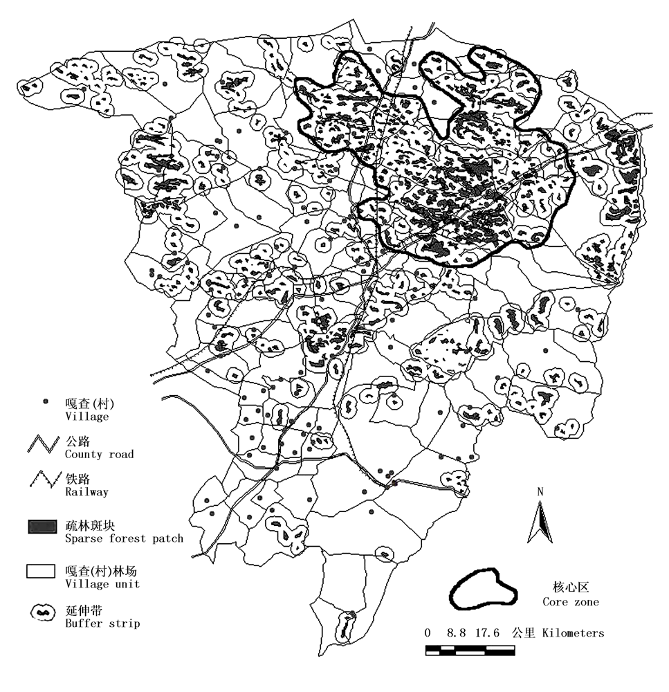
Fig.1 The map of Ulmus pumila sparse forest patches location, core zone design for the potential nature reserve in Zhenglan Banner, Hunshandak Sandland
| [1] | Chen LD (陈利顶), Fu BJ (傅伯杰), Liu XH (刘雪华) (2000). The landscape design and species conservation for nature reserve, taking Wolong Nature Reserve as a case. Journal of Natural Resources (自然资源学报), 15,164-169. (in Chinese with English abstract) |
| [2] | Cui GF (崔国发), Li JQ (李俊清), Niu SK (牛树奎) (2000). The establishment and design of Beijing Labagoumen Nature Reserve. Journal of Beijing Forestry University (Natural Science Edition) (北京林业大学学报(自然科学版)), 22,40-46. (in Chinese with English abstract) |
| [3] | Huslshoff RM (1995). Landscape indices describing a Dutch landscape. Landscape Ecology, 10,101-111. |
| [4] |
Kingsland S (2002). Designing nature reserves: adapting ecology to real-world problems. Endeavour, 26,9-15.
DOI URL PMID |
| [5] | Li WH (李文华), Guo JP (郭江平), Zhao Q (赵强) (2000). Background evaluation and plan for natural desert reserve construction in Ebinur Lake, Xinjiang. Journal of Desert Research (中国沙漠), 20,278-283. (in Chinese with English abstract) |
| [6] | Li YM (李义明), Li DM (李典谟) (1996). The principle theories and methods for nature reserve design. Chinese Biodiversity (生物多样性), 4,32-40. (in Chinese with English abstract) |
| [7] | Ma KM (马克明), Fu BJ (傅伯杰) (2000). Landscape pattern and fragmentation in Donglingshan Mountain region. Acta Phytoecologica Sinica (植物生态学报), 24,320-326. (in Chinese with English abstract) |
| [8] | Ma KP (马克平) (2001). Hotspots assessment and conservation priorities identification of biodiversity in China should be emphasized. Acta Phytoecologica Sinica (植物生态学报), 25,124-125. (in Chinese) |
| [9] | Noss RF, Cooperrider AY (1994). Saving Nature's Legacy: Protecting and Restoring Biodiversity. Island Press, New York,131-132. |
| [10] | Pielou EC (1994). The Interpretation of Ecological Data: a Primer of Classification and Ordination. John Wiley & Son, New York,264-269. |
| [11] | Riitters KH, O'Neill RV, Hunsaker CT (1995). A factor analysis of landscape pattern and structure metrics. Landscape Ecology, 10,23-29. |
| [12] | Schumaker NH (1996). Using landscape indices to predict habitat connectivity. Ecology, 77,1210-1225. |
| [13] | Tang XP (唐小平) (2003). Basic ecological traits of the Three-Rivers' Sources area and the design of the nature reserve. Forest Resource Management (林业资源管理), (1),38-45. (in Chinese with English abstract) |
| [14] | Wu JG (邬建国) (1990). The theory of nature reserve and the theory of MacArthur-Wilson. Acta Ecologica Sinica (生态学报), 10,187-191. (in Chinese with English abstract) |
| [15] | Wu JG (邬建国) (2000). Landscape Ecology: Pattern, Process, Size and Scale (景观生态学——格局、过程、尺度与等级). Higher Education Press, Beijing,155-198. (in Chinese) |
| [16] | Xiao DL (肖笃宁) (1991). Landscape: Theory, Method and Application (景观生态学理论、方法与应用). China Forestry Publishing House, Beijing,258-301. (in Chinese) |
| [17] | Zhang DL (张敦论), Lin XF (林新福), Wang TZ (王铁章) (1984). Ulmus pumila (白榆). China Forestry Publishing House, Beijing,16-64. (in Chinese) |
| Viewed | ||||||
|
Full text |
|
|||||
|
Abstract |
|
|||||
Copyright © 2022 Chinese Journal of Plant Ecology
Tel: 010-62836134, 62836138, E-mail: apes@ibcas.ac.cn, cjpe@ibcas.ac.cn