
Chin J Plant Ecol ›› 2020, Vol. 44 ›› Issue (2): 128-178.DOI: 10.17521/cjpe.2019.0272 cstr: 32100.14.cjpe.2019.0272
Special Issue: 植被生态学
• Research Articles • Previous Articles
WANG Guo-Hong1,*( ),FANG Jing-Yun1,2,GUO Ke1,XIE Zong-Qiang1,TANG Zhi-Yao2,SHEN Ze-Hao2,WANG Ren-Qing3,WANG Xiang-Ping4,WANG De-Li5,QIANG Sheng6,YU Dan7,PENG Shao-Lin8,DA Liang-Jun9,LIU Qing10,LIANG Cun-Zhu11
Received:2019-10-15
Accepted:2019-11-25
Online:2020-02-20
Published:2020-04-08
Contact:
Guo-Hong WANG
Supported by:WANG Guo-Hong, FANG Jing-Yun, GUO Ke, XIE Zong-Qiang, TANG Zhi-Yao, SHEN Ze-Hao, WANG Ren-Qing, WANG Xiang-Ping, WANG De-Li, QIANG Sheng, YU Dan, PENG Shao-Lin, DA Liang-Jun, LIU Qing, LIANG Cun-Zhu. Contents and protocols for the classification and description of Vegetation Formations, Alliances and Associations of vegetation of China[J]. Chin J Plant Ecol, 2020, 44(2): 128-178.
Add to citation manager EndNote|Ris|BibTeX
URL: https://www.plant-ecology.com/EN/10.17521/cjpe.2019.0272
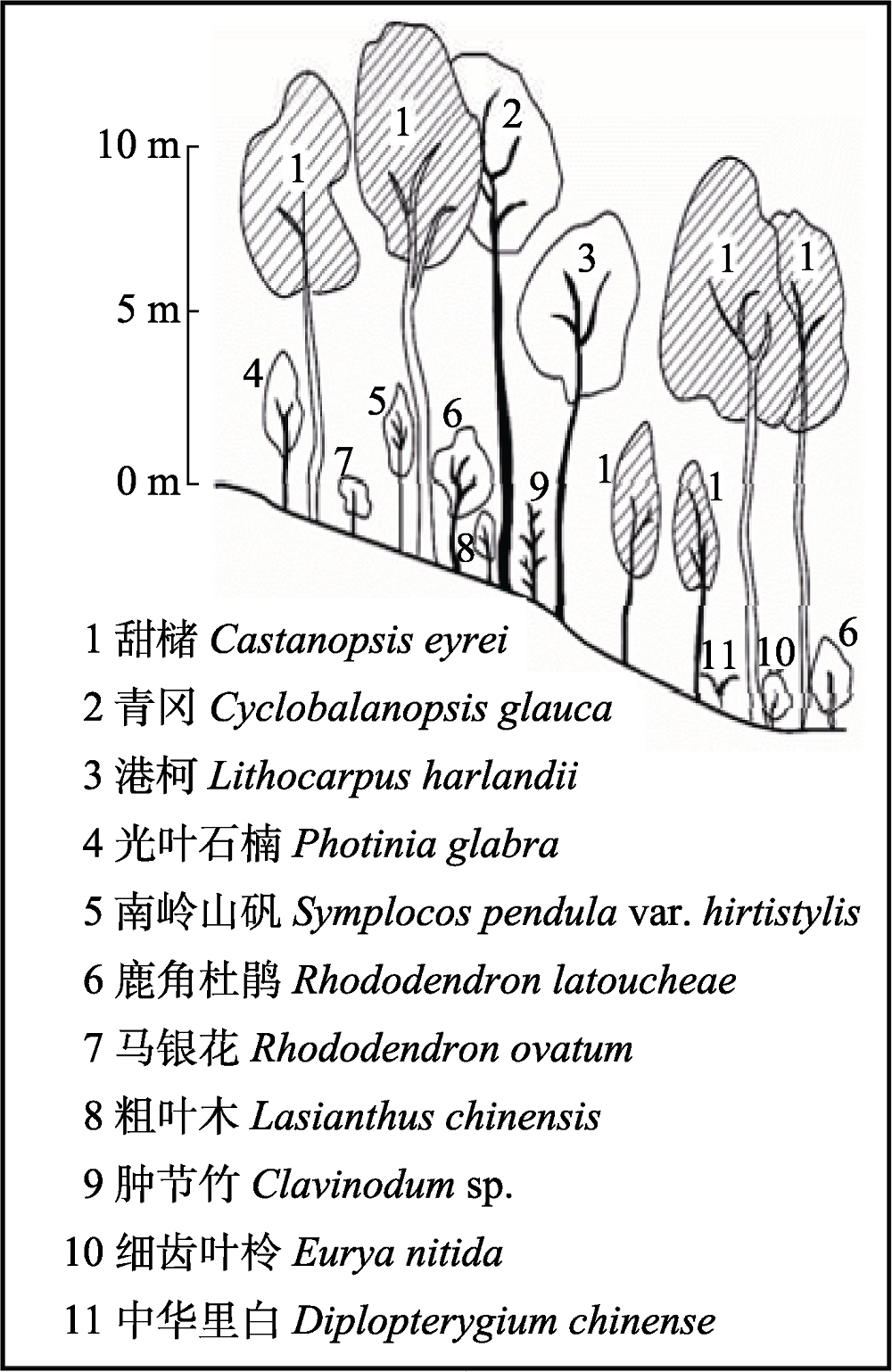
Fig. 1 Illustration of vertical structure of a forest community (modified from Fujian Vegetation (Lin, 1990)).
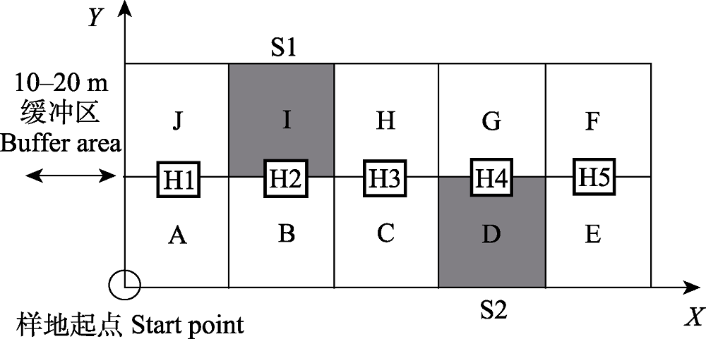
Fig. 2 Plot setting and quadrate coding for forest communities. The 20 m × 50 m plot is composed of 10 quadrates (A-J), each with an area of 10 m × 10 m. The shadowed quadrates (S1 and S2) are selected for shrub layer investigation, and subplots (H1-H5, 1 m × 1 m) are selected for herbaceous layer investigation. A buffer zone of 10-20 m at each side of the plot is necessary to keep the plot away from apparent human activities. Modified from Fang et al. (2009).
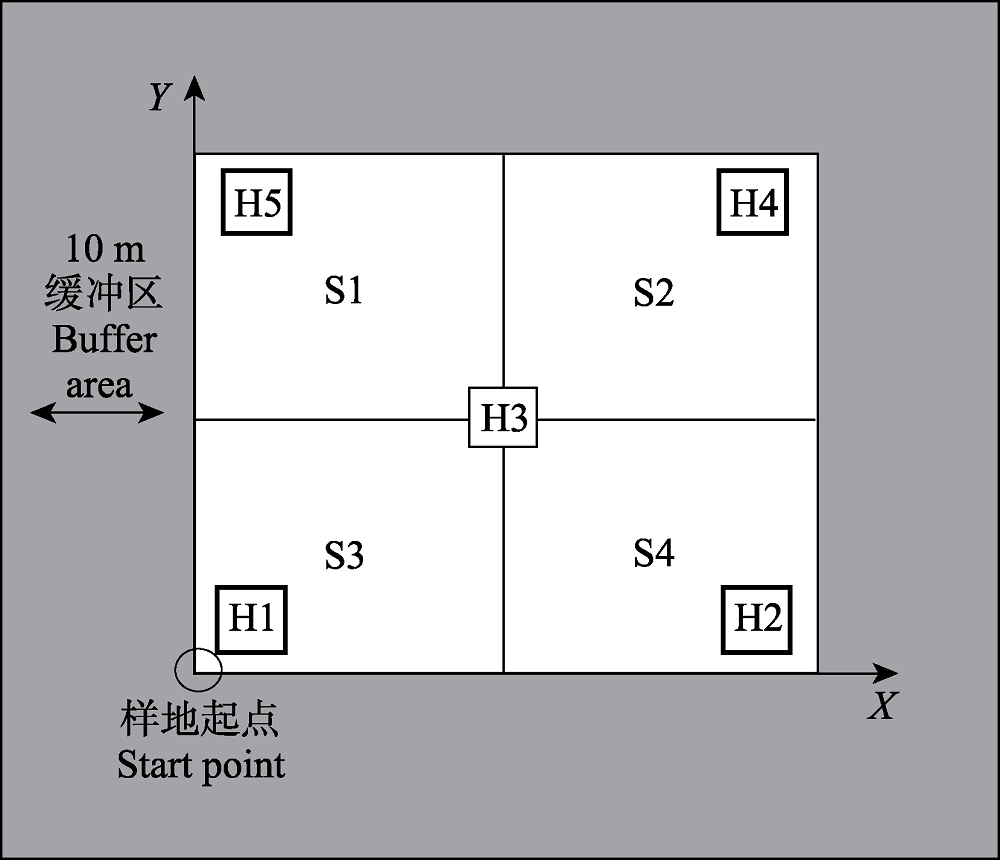
Fig. 3 Plot setting of shrub (grassland) communities (10 m × 10 m). Four subplots (S1-S4, 5 m × 5 m) for shrub layer and five subplots for herb layer (H1-H5, 1 m × 1 m) are selected for investigation within each 10 m × 10 m plot. A buffer zone of 10 m at each side of the plot is necessary to keep the plot away from apparent human activities (Fang et al., 2009).
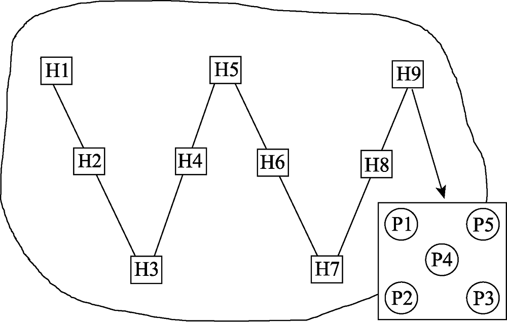
Fig. 4 Plot setting of agricultural vegetation (H1-H9) and soil seed pool (P1-P5) on a field patch.
 |
Table 1 Synoptic table of a forest alliance
| |
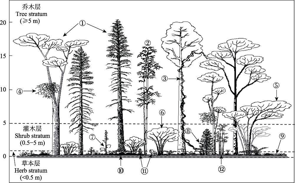
Fig. 5 An illustration of strata showing growth forms of individual plants as delineated. ① mature trees, recorded as part of the tree stratum; ②, ③, ④ and ⑤ are bamboos, woody vines, parasitic plants and large shrubs that appear in the tree stratum, respectively, recorded as part of the tree stratum; ⑥ a plant having the shrub growth form but not projecting vertically into the tree stratum, recorded as part of the shrub stratum; ⑦ tall herbs although projecting vertically into the shrub stratum, recorded as part of the herb stratum; ⑧, ? and ? are samplings and bamboos that appear in the shrub and herb stratum, respectively, recorded as part of the corresponding stratum; ⑨ herb plants, recorded as part of the herb stratum; ⑩ mosses, recorded as part of the ground stratum (not delineated).
| 1 用于JUICE分析的数据表格( 2 JUICE软件导入数据路径: File—Import—Table。有7种文件格式可选, 常用“From Spreadsheet file (.csv)”或“From Clipboard as Spreadsheet”, 如果采用后者的导入方式, 则连续点击“Next”, 在盖度数据格式(Cover Values)中选择“Percentage Values”, 然后点击“Finish”。 3 数据导入完成后, 在“Analysis”栏目, 选择Twinspan或其他方法进行聚类分析, 分类结果要根据实际情况进行评估, 以确定出较为合理的分类方案。在调整分类方案过程中, 可使用“Shift+鼠标左键”添加或删除样方间的分割线, 用“Shift+鼠标右键”可以给一个或一组样方选择颜色。如有必要, 可启动聚类分析程序对特定颜色覆盖的样方进行再分类。由于中国植被分类专家系统没有建立起来, 目前只能根据样方资料、环境条件等因子对数量分类的结果进行评估或修正。分类结果表中默认的样方编码是系统自动生成的, 如果需要查看原始输入的样方号, 可在“Head”栏目中选择“Original Number”。 4 分类方案确定后, 点击“Synoptic Table”栏目, 选择“Percentage Frequency”, 可保证数据表中显示频率值; 选择“Fidelity”, 分类数据表中将显示特征值。在“Threshold Values”栏目可以设定相关阈值和对特征值进行Fisher检验的显著性水平(α = 0.05, 0.01, 0.001)。例如, 可设置诊断值25、50分别为低诊断值的特征种和高诊断值的特征种的阈值; 同样地, 可设置频率值60为常见种或恒有种的频率阈值; 可设置盖度值75为筛选单优势种的盖度阈值等。对不同属性的物种, 可在分类表中用不同的颜色显示。阈值设置完成后, 在“Synoptic Table”栏目, 点击“Sort Species in Synoptic Table”, 在出现的提示框中选择“Fidelity Measure ”, 点击“Sort”, 即可显示分类表。 5 计算并输出结果: 点击“Synoptic Table”, 在“Analysis of Columns of Synoptic Table”中, 可以设置相关阈值(如果已经设置, 此处可忽略), 点击“Export”—“Export Clusters 1-n” (n是分类单元的个数, 在程序中将显示具体数字), 将输出每个植被分类单元的特征种、常见种和优势种, 输出的文件名是“EXPORT.RTF”。连续点击“Close”和“Cancel”, 退出对话窗口。 6 数据输出路径: 点击File—Export, 在弹出窗口的第一行, 即显示输出文件“EXPORT.RTF”所在的路径。通过File—Export—Synoptic Table路径, 可输出分类表到带逗号的.csv文件, 此文件可以用Word和Excel进行编辑。 |
Box 1 Calculation procedures for JUICE program
| 1 用于JUICE分析的数据表格( 2 JUICE软件导入数据路径: File—Import—Table。有7种文件格式可选, 常用“From Spreadsheet file (.csv)”或“From Clipboard as Spreadsheet”, 如果采用后者的导入方式, 则连续点击“Next”, 在盖度数据格式(Cover Values)中选择“Percentage Values”, 然后点击“Finish”。 3 数据导入完成后, 在“Analysis”栏目, 选择Twinspan或其他方法进行聚类分析, 分类结果要根据实际情况进行评估, 以确定出较为合理的分类方案。在调整分类方案过程中, 可使用“Shift+鼠标左键”添加或删除样方间的分割线, 用“Shift+鼠标右键”可以给一个或一组样方选择颜色。如有必要, 可启动聚类分析程序对特定颜色覆盖的样方进行再分类。由于中国植被分类专家系统没有建立起来, 目前只能根据样方资料、环境条件等因子对数量分类的结果进行评估或修正。分类结果表中默认的样方编码是系统自动生成的, 如果需要查看原始输入的样方号, 可在“Head”栏目中选择“Original Number”。 4 分类方案确定后, 点击“Synoptic Table”栏目, 选择“Percentage Frequency”, 可保证数据表中显示频率值; 选择“Fidelity”, 分类数据表中将显示特征值。在“Threshold Values”栏目可以设定相关阈值和对特征值进行Fisher检验的显著性水平(α = 0.05, 0.01, 0.001)。例如, 可设置诊断值25、50分别为低诊断值的特征种和高诊断值的特征种的阈值; 同样地, 可设置频率值60为常见种或恒有种的频率阈值; 可设置盖度值75为筛选单优势种的盖度阈值等。对不同属性的物种, 可在分类表中用不同的颜色显示。阈值设置完成后, 在“Synoptic Table”栏目, 点击“Sort Species in Synoptic Table”, 在出现的提示框中选择“Fidelity Measure ”, 点击“Sort”, 即可显示分类表。 5 计算并输出结果: 点击“Synoptic Table”, 在“Analysis of Columns of Synoptic Table”中, 可以设置相关阈值(如果已经设置, 此处可忽略), 点击“Export”—“Export Clusters 1-n” (n是分类单元的个数, 在程序中将显示具体数字), 将输出每个植被分类单元的特征种、常见种和优势种, 输出的文件名是“EXPORT.RTF”。连续点击“Close”和“Cancel”, 退出对话窗口。 6 数据输出路径: 点击File—Export, 在弹出窗口的第一行, 即显示输出文件“EXPORT.RTF”所在的路径。通过File—Export—Synoptic Table路径, 可输出分类表到带逗号的.csv文件, 此文件可以用Word和Excel进行编辑。 |
 |
Table 2 Example data for environmental characteristics and supraterraneous stratifications of association groups and associations from a forest alliance
| |
| A1 乔木层由青海云杉单优势种组成,相对优势度≥75%。 B1 苔藓层盖度≥20%,无灌木或有稀疏的灌木和草本植物(盖度<20%)。PC-I 青海云杉-苔藓 常绿针叶林 Picea crassifolia - Moss Evergreen Needleleaf Forest B2 林下灌木稀疏,草本层盖度≥20%;或兼有灌木层和草本层,二者的盖度≥20%。 C1 林下灌木稀疏,盖度<20%;草本层盖度≥20%。PC-II 青海云杉-草本 常绿针叶林 Picea crassifolia - Herb Evergreen Needleleaf Forest C2 林下有明显的灌木层和草本层,二者的盖度≥20%。PC-III 青海云杉-灌木-草本 常绿针叶林 Picea crassifolia - Shrub - Herb Evergreen Needleleaf Forest A2 乔木层除了青海云杉(相对优势度<75%)外,还有青扦、杜松、山杨和桦木等针阔叶乔木混生,组成共优势种。 B1 乔木层由青海云杉和青扦组成共优势种。PC-IV 青海云杉+青扦-灌木-草本 常绿针叶林 Picea crassifolia + Picea wilsonii - Shrub - Herb Evergreen Needleleaf Forest B2 乔木层由青海云杉、杜松和杨桦等阔叶乔木组成。PC-V 青海云杉-山杨-杜松-灌木-草本 针叶与阔叶混交林 Picea crassifolia - Populus davidiana - Juniperus rigida - Shrub - Herb Mixed Needleleaf and Broadleaf Forest |
Box 2 A part of the key to Picea crassifolia Forest Alliance
| A1 乔木层由青海云杉单优势种组成,相对优势度≥75%。 B1 苔藓层盖度≥20%,无灌木或有稀疏的灌木和草本植物(盖度<20%)。PC-I 青海云杉-苔藓 常绿针叶林 Picea crassifolia - Moss Evergreen Needleleaf Forest B2 林下灌木稀疏,草本层盖度≥20%;或兼有灌木层和草本层,二者的盖度≥20%。 C1 林下灌木稀疏,盖度<20%;草本层盖度≥20%。PC-II 青海云杉-草本 常绿针叶林 Picea crassifolia - Herb Evergreen Needleleaf Forest C2 林下有明显的灌木层和草本层,二者的盖度≥20%。PC-III 青海云杉-灌木-草本 常绿针叶林 Picea crassifolia - Shrub - Herb Evergreen Needleleaf Forest A2 乔木层除了青海云杉(相对优势度<75%)外,还有青扦、杜松、山杨和桦木等针阔叶乔木混生,组成共优势种。 B1 乔木层由青海云杉和青扦组成共优势种。PC-IV 青海云杉+青扦-灌木-草本 常绿针叶林 Picea crassifolia + Picea wilsonii - Shrub - Herb Evergreen Needleleaf Forest B2 乔木层由青海云杉、杜松和杨桦等阔叶乔木组成。PC-V 青海云杉-山杨-杜松-灌木-草本 针叶与阔叶混交林 Picea crassifolia - Populus davidiana - Juniperus rigida - Shrub - Herb Mixed Needleleaf and Broadleaf Forest |
 |
Appendix Table 1 Sample table for plant community survey
| |
| 样方号 | 调查人 | 页数 | / | |||||||
|---|---|---|---|---|---|---|---|---|---|---|
| 样格号 | 树号 | 树种 | 胸径/cm | 树高/m | 活枝下高/m | 冠幅/m | 备注 | |||
| 前期 | 当期 | EW | SN | |||||||
Appendix Table 1-2 Sample table for tree stratum of a plot
| 样方号 | 调查人 | 页数 | / | |||||||
|---|---|---|---|---|---|---|---|---|---|---|
| 样格号 | 树号 | 树种 | 胸径/cm | 树高/m | 活枝下高/m | 冠幅/m | 备注 | |||
| 前期 | 当期 | EW | SN | |||||||
| 样方号 | 调查人 | 页数 | / | ||||||
|---|---|---|---|---|---|---|---|---|---|
| 样格号 | 物种 | 基径/cm | 平均高度/cm | 冠幅a/cm | 冠幅b/cm | 株丛数 | 盖度/% | 备注 | |
Appendix Table 1-3 Sample table for shrub stratum of a plot
| 样方号 | 调查人 | 页数 | / | ||||||
|---|---|---|---|---|---|---|---|---|---|
| 样格号 | 物种 | 基径/cm | 平均高度/cm | 冠幅a/cm | 冠幅b/cm | 株丛数 | 盖度/% | 备注 | |
| 样方号 | 调查人 | 页数 | / | ||||
|---|---|---|---|---|---|---|---|
| 小样方号 | 物种 | 多度 | 平均高度/cm | 盖度/% | 小样方总盖度/% | 备注 | |
Appendix Table 1-4 Sample table for herb or ground stratum of a plot
| 样方号 | 调查人 | 页数 | / | ||||
|---|---|---|---|---|---|---|---|
| 小样方号 | 物种 | 多度 | 平均高度/cm | 盖度/% | 小样方总盖度/% | 备注 | |
 |
Appendix Table 2 A sample table for the summary of altitude ranges and climatic factors of a vegetation type
| |
| 检索信息 | 编码 | 1 | 2 | …… |
|---|---|---|---|---|
| 样方号 | ||||
| 植被类型 | 植被名称 | |||
| 地理分布 | 省区 | |||
| 地点 | ||||
| 纬度(° N) | ||||
| 经度(° E) | ||||
| 海拔(m) | ||||
| 生境信息 | 地形地貌 | |||
| 土壤类型 | ||||
| 土壤质地 | ||||
| 坡度(°) | ||||
| 坡向(°) | ||||
| 坡位 | ||||
| 水分状况 | ||||
| 植被起源 | ||||
| 演替阶段 | ||||
| 干扰信息 | 干扰类型 | |||
| 干扰强度 | ||||
| 乔木层 | 样方面积(m2) | |||
| 盖度 | 盖度(%) | |||
| 胸径 | 平均值(cm) | |||
| 最小值(cm) | ||||
| 最大值(cm) | ||||
| 高度 | 平均值(m) | |||
| 最小值(m) | ||||
| 最大值(m) | ||||
| 物种丰富度 | ||||
| 检索信息 | 编码 | 1 | 2 | …… |
| 灌木层 | 样方面积(m2) | |||
| 盖度 | 平均值(%) | |||
| 最小值(%) | ||||
| 最大值(%) | ||||
| 高度 | 平均值(cm) | |||
| 最小值(cm) | ||||
| 最大值(cm) | ||||
| 物种丰富度 | ||||
| 草本层 | 样方面积(m2) | |||
| 盖度 | 平均值(%) | |||
| 最小值(%) | ||||
| 最大值(%) | ||||
| 高度 | 平均值(cm) | |||
| 最小值(cm) | ||||
| 最大值(cm) | ||||
| 物种丰富度 | ||||
| 地被层 | 样方面积(m2) | |||
| 盖度 | 平均值(%) | |||
| 最小值(%) | ||||
| 最大值(%) | ||||
| 高度 | 平均值(cm) | |||
| 最小值(cm) | ||||
| 最大值(cm) | ||||
| 物种丰富度 | ||||
| 地表裸露度 | 地表裸露度(%) | |||
| 凋落物 | 凋落物厚度(cm) | |||
| 凋落物覆盖度(%) | ||||
| 调查人 | ||||
| 日期 | ||||
| 备注 |
Appendix Table 3 Plot basic information (This table is to be transposed in Excel)
| 检索信息 | 编码 | 1 | 2 | …… |
|---|---|---|---|---|
| 样方号 | ||||
| 植被类型 | 植被名称 | |||
| 地理分布 | 省区 | |||
| 地点 | ||||
| 纬度(° N) | ||||
| 经度(° E) | ||||
| 海拔(m) | ||||
| 生境信息 | 地形地貌 | |||
| 土壤类型 | ||||
| 土壤质地 | ||||
| 坡度(°) | ||||
| 坡向(°) | ||||
| 坡位 | ||||
| 水分状况 | ||||
| 植被起源 | ||||
| 演替阶段 | ||||
| 干扰信息 | 干扰类型 | |||
| 干扰强度 | ||||
| 乔木层 | 样方面积(m2) | |||
| 盖度 | 盖度(%) | |||
| 胸径 | 平均值(cm) | |||
| 最小值(cm) | ||||
| 最大值(cm) | ||||
| 高度 | 平均值(m) | |||
| 最小值(m) | ||||
| 最大值(m) | ||||
| 物种丰富度 | ||||
| 检索信息 | 编码 | 1 | 2 | …… |
| 灌木层 | 样方面积(m2) | |||
| 盖度 | 平均值(%) | |||
| 最小值(%) | ||||
| 最大值(%) | ||||
| 高度 | 平均值(cm) | |||
| 最小值(cm) | ||||
| 最大值(cm) | ||||
| 物种丰富度 | ||||
| 草本层 | 样方面积(m2) | |||
| 盖度 | 平均值(%) | |||
| 最小值(%) | ||||
| 最大值(%) | ||||
| 高度 | 平均值(cm) | |||
| 最小值(cm) | ||||
| 最大值(cm) | ||||
| 物种丰富度 | ||||
| 地被层 | 样方面积(m2) | |||
| 盖度 | 平均值(%) | |||
| 最小值(%) | ||||
| 最大值(%) | ||||
| 高度 | 平均值(cm) | |||
| 最小值(cm) | ||||
| 最大值(cm) | ||||
| 物种丰富度 | ||||
| 地表裸露度 | 地表裸露度(%) | |||
| 凋落物 | 凋落物厚度(cm) | |||
| 凋落物覆盖度(%) | ||||
| 调查人 | ||||
| 日期 | ||||
| 备注 |
| 乔木层 t | 密度(株/600 m2)* | 胸径(cm) | 高度(m) | 频度(%) | 重要值 | ||||
|---|---|---|---|---|---|---|---|---|---|
| 灌木层 s | 密度(株丛/100 m2) | 盖度(%) | 高度(cm) | 频度(%) | 重要值 | ||||
| 草本层 h | 密度(株丛/5 m2)或德氏多度 | 盖度(%) | 高度(cm) | 频度(%) | 重要值 | ||||
| 地被层 m | 盖度(%) | 高度(cm) | 频度(%) | 重要值 | |||||
| 样方号 | 层代码** | 中文名 | 拉丁名 | 层号 | |||||
| 样方1 | t | ||||||||
| 样方1 | t | ||||||||
| 样方1 | s | ||||||||
| 样方1 | s | ||||||||
| 样方1 | h | ||||||||
| 样方1 | h | ||||||||
| 样方1 | m | ||||||||
| 样方1 | m | ||||||||
| … | … | … | … | … | … | … | … | … | … |
Appendix Table 4 A summary for plot data
| 乔木层 t | 密度(株/600 m2)* | 胸径(cm) | 高度(m) | 频度(%) | 重要值 | ||||
|---|---|---|---|---|---|---|---|---|---|
| 灌木层 s | 密度(株丛/100 m2) | 盖度(%) | 高度(cm) | 频度(%) | 重要值 | ||||
| 草本层 h | 密度(株丛/5 m2)或德氏多度 | 盖度(%) | 高度(cm) | 频度(%) | 重要值 | ||||
| 地被层 m | 盖度(%) | 高度(cm) | 频度(%) | 重要值 | |||||
| 样方号 | 层代码** | 中文名 | 拉丁名 | 层号 | |||||
| 样方1 | t | ||||||||
| 样方1 | t | ||||||||
| 样方1 | s | ||||||||
| 样方1 | s | ||||||||
| 样方1 | h | ||||||||
| 样方1 | h | ||||||||
| 样方1 | m | ||||||||
| 样方1 | m | ||||||||
| … | … | … | … | … | … | … | … | … | … |
| 群系或群系优势种科学名称 | |||||||
|---|---|---|---|---|---|---|---|
| 层号# | 样方1 (阿拉伯数字组合) | 样方2 | … | … | … | … | |
| 物种1 (拉丁名,下同) | 1 | 0 | 0 | 0 | 0 | 67* | 0 |
| 物种2 | 1 | 0 | 0 | 0 | 0 | 0 | 0 |
| … | … | … | … | … | … | … | … |
Appendix Table 5 Species by plot data
| 群系或群系优势种科学名称 | |||||||
|---|---|---|---|---|---|---|---|
| 层号# | 样方1 (阿拉伯数字组合) | 样方2 | … | … | … | … | |
| 物种1 (拉丁名,下同) | 1 | 0 | 0 | 0 | 0 | 67* | 0 |
| 物种2 | 1 | 0 | 0 | 0 | 0 | 0 | 0 |
| … | … | … | … | … | … | … | … |
| 中文 Chinese | 英文 English | 英文缩写 English abbreviation | 中文 Chinese | 英文 English | 英文缩写 English abbreviation |
|---|---|---|---|---|---|
| 冲积平原 | Alluvial Plain | AP | 沙地 | Sandland | SA |
| 三角洲 | Delta | D | 戈壁 | Gobi | GO |
| 冲积扇 | Alluvial Fan | AF | 风蚀残丘 | Deflation Monadnock | DM |
| 波状平原 | Wavy Plain | WP | 剥蚀台地 | Deflation Platform | DP |
| 台地 | Platform | PF | 雅丹 | Yardang Landform | YL |
| 洼地 | Depression | DE | 风蚀洼地 | Deflation Hollow | DH |
| 河谷 | Valley | VA | 冲沟 | Gully | GU |
| 山地 | Mountain | MO | 西坡 | Western Slope | W |
| 丘陵 | Hill | HI | 西北坡 | Northwestern Slope | NW |
| 高原 | Plateau | PL | 北坡 | Northern Slope | N |
| 喀斯特 | Karst | KA | 东北坡 | Northeastern Slope | NE |
| 冰川 | Glacier | GL | 东坡 | Eastern Slope | E |
| 阶地 | Terrace | TE | 东南坡 | Southeastern Slope | SE |
| 河漫滩 | Floodplain | FL | 南坡 | Southern Slope | S |
| 湖滩 | Lake Beach | LB | 西南坡 | Southwestern Slope | SW |
| 沼泽 | Swamp | SWA | 下坡 | Lower Slope | LS |
| 湖泊 | Lake | LA | 中坡 | Middle Slope | MS |
| 海滩 | Beach | BE | 上坡 | Upper Slope | US |
| 沙丘 | Dune | DU | 山顶或山脊 | Ridge | RI |
| 丘间洼地 | Inter-Dune Depression | ID |
Appendix Table 6 A list of commonly used terms of terrain and landform for the description of vegetation
| 中文 Chinese | 英文 English | 英文缩写 English abbreviation | 中文 Chinese | 英文 English | 英文缩写 English abbreviation |
|---|---|---|---|---|---|
| 冲积平原 | Alluvial Plain | AP | 沙地 | Sandland | SA |
| 三角洲 | Delta | D | 戈壁 | Gobi | GO |
| 冲积扇 | Alluvial Fan | AF | 风蚀残丘 | Deflation Monadnock | DM |
| 波状平原 | Wavy Plain | WP | 剥蚀台地 | Deflation Platform | DP |
| 台地 | Platform | PF | 雅丹 | Yardang Landform | YL |
| 洼地 | Depression | DE | 风蚀洼地 | Deflation Hollow | DH |
| 河谷 | Valley | VA | 冲沟 | Gully | GU |
| 山地 | Mountain | MO | 西坡 | Western Slope | W |
| 丘陵 | Hill | HI | 西北坡 | Northwestern Slope | NW |
| 高原 | Plateau | PL | 北坡 | Northern Slope | N |
| 喀斯特 | Karst | KA | 东北坡 | Northeastern Slope | NE |
| 冰川 | Glacier | GL | 东坡 | Eastern Slope | E |
| 阶地 | Terrace | TE | 东南坡 | Southeastern Slope | SE |
| 河漫滩 | Floodplain | FL | 南坡 | Southern Slope | S |
| 湖滩 | Lake Beach | LB | 西南坡 | Southwestern Slope | SW |
| 沼泽 | Swamp | SWA | 下坡 | Lower Slope | LS |
| 湖泊 | Lake | LA | 中坡 | Middle Slope | MS |
| 海滩 | Beach | BE | 上坡 | Upper Slope | US |
| 沙丘 | Dune | DU | 山顶或山脊 | Ridge | RI |
| 丘间洼地 | Inter-Dune Depression | ID |
 |
Appendix Table 7 A sample table for the summary of taxonomic composition of a vegetation type
| |
 |
Appendix Table 8 A sample table for the summary of the areal type of seed plant species of a vegetation type
| |
 |
Appendix Table 9 A sample table for the summary of life-form spectrum of a vegetation type
| |
| [1] | Bigwood DW, Inouye DW (1988). Spatial pattern analysis of seed banks: an improved method and optimized sampling. Ecology, 69, 497-507. |
| [2] | Breiman L, Friedman JH, Olshen RA, Stone CJ (1984). Classification and Regression Trees. Chapman & Hall, Monterey. |
| [3] | Ding YH (2013). Climate of China. Science Press, Beijing. |
| [ 丁一汇 (2013). 中国气候. 科学出版社, 北京.] | |
| [4] | Faber-Langendoen D, Keeler-Wolf T, Meidinger D, Tart D, Hoagland B, Josse C, Navarro G, Ponomarenko S, Saucier J-P, Weakley A, Comer P (2014). EcoVeg: a new approach to vegetation description and classification. Ecological Monographs, 84, 533-561. |
| [5] | Fang JY, Guo K, Wang GH, Tang ZY, Xie ZQ, Shen ZH, Wang RQ, Qiang S, Liang CZ, Da LJ, Yu D (2020). Vegetation classification system and classification of vegetation types used for the compilation of vegetation of China. Chinese Journal of Plant Ecology, 44, 96-110. |
| [ 方精云, 郭柯, 王国宏, 唐志尧, 谢宗强, 沈泽昊, 王仁卿, 强胜, 梁存柱, 达良俊, 于丹 (2020). 《中国植被志》的植被分类系统、植被类型划分及编排体系. 植物生态学报, 44, 96-110.] | |
| [6] | Fang JY, Wang XP, Shen ZH, Tang ZY, He JS, Yu D, Jiang Y, Wang ZH, Zheng CY, Zhu JL, Guo ZD (2009). Methods and protocols for plant community inventory. Biodiversity Science, 17, 533-548. |
| [ 方精云, 王襄平, 沈泽昊, 唐志尧, 贺金生, 于丹, 江源, 王志恒, 郑成洋, 朱江玲, 郭兆迪 (2009). 植物群落清查的主要内容、方法和技术规范. 生物多样性, 17, 533-548.] | |
| [7] | Federal Geographic Data Committee (2008). National Vegetation Classification Standard. 2nd ed. [2019-10-10]. http:// www.fgdc.gov/standards/projects/FGDC-standards-projects/vegetation/NVCS_V2_FINAL_2008-02.pdf. |
| [8] | Gong ZT, Huang RJ, Zhang GL (2014). Soil Geography of China. Science Press, Beijing. |
| [ 龚子同, 黄荣金, 张甘霖 (2014). 中国土壤地理. 科学出版社, 北京.] | |
| [9] | Guo K, Fang JY, Wang GH, Tang ZY, Xie ZQ, Shen ZH, Wang RQ, Qiang S, Liang CZ, Da LJ, Yu D (2020). A revised scheme of vegetation classification system of China. Chinese Journal of Plant Ecology, 44, 111-127. |
| [ 郭柯, 方精云, 王国宏, 唐志尧, 谢宗强, 沈泽昊, 王仁卿, 强胜, 梁存柱, 达良俊, 于丹 (2020). 中国植被分类系统修订方案. 植物生态学报, 44, 111-127.] | |
| [10] | Jennings MD, Faber-Langendoen D, Loucks OL, Peet RK, Roberts D (2009). Standards for Associations and Alliances of the U.S. National Vegetation Classification. Ecological Monographs, 79, 173-199. |
| [11] | Lin P (1990). Vegetation of Fujian. Fujian Science and Technology Publishing House, Fuzhou. |
| [ 林鹏 (1990). 福建植被. 福建科学技术出版社, 福州.] | |
| [12] | Ma B, Qiang S, Wei SH (2004). Research method of farmland weed seed bank. Weed Science, ( 2), 5-8. |
| [ 马波, 强胜, 魏守辉 (2004). 农田杂草种子库研究方法. 杂草科学, ( 2), 5-8.] | |
| [13] | Qiang S (2011). Weed Science. 2nd ed. China Agriculture Press, Beijing. |
| [ 强胜 (2011). 杂草学. 2版. 中国农业出版社, 北京.] | |
| [14] | Research Institute of Forestry, Chinese Academy of Forestry Sciences (1986). Forest Soil of China. Science Press, Beijing. |
| [ 中国林业科学研究院林业研究所 (1986). 中国森林土壤. 科学出版社, 北京.] | |
| [15] | Rodwell JS, Pigott CD, Ratcliffe DA, Malloch AJC, Birks HJB, Proctor MCF, Shimwell DW, Huntley JP, Radford E, Wigginton MJ, Wilkins P (1991). British Plant Communities: Vol. I. Cambridge University Press, Cambridge, UK. |
| [16] | Song YC (2013). Evergreen Broad-leaved Forests in China: Classification-Ecology-Conservation. Science Press, Beijing. |
| [ 宋永昌 (2013). 中国常绿阔叶林: 分类·生态·保育. 科学出版社, 北京.] | |
| [17] | Song YC (2017). Vegetation Ecology. 2nd ed. Higher Education Press, Beijing. |
| [ 宋永昌 (2017). 植被生态学. 2版. 高等教育出版社, 北京.] | |
| [18] | Song YC, Yan ER, Song K (2017). An update of the vegetation classification in China. Chinese Journal of Plant Ecology, 41, 269-278. |
| [ 宋永昌, 阎恩荣, 宋坤 (2017). 再议中国的植被分类系统. 植物生态学报, 41, 269-278.] | |
| [19] | The Editorial Committee of Natural Geography of China, Chinese Academy of Sciences (1980). Natural Geography of China: Landform. Science Press, Beijing. |
| [ 中国科学院《中国自然地理》编辑委员会 (1980). 中国自然地理: 地貌. 科学出版社, 北京.] | |
| [20] | The Editorial Committee of Natural Geography of China, Chinese Academy of Sciences (1981). Natural Geography of China: Soil Geography. Science Press, Beijing. |
| [ 中国科学院《中国自然地理》编辑委员会 (1981). 中国自然地理: 土壤地理. 科学出版社, 北京.] | |
| [21] | The Editorial Committee of Natural Geography of China, Chinese Academy of Sciences (1984). Natural Geography of China: Climate. Science Press, Beijing. |
| [ 中国科学院《中国自然地理》编辑委员会 (1984). 中国自然地理: 气候. 科学出版社, 北京.] | |
| [22] | The Editorial Committee of Vegetation Map of China, Chinese Academy of Sciences (2007a). Vegetation Map of the People’s Republic of China 1:1 000 000. Geological Publishing House, Beijing. |
| [ 中国科学院中国植被图编辑委员会 (2007a). 中华人民共和国植被图1:1 000 000. 地质出版社, 北京.] | |
| [23] | The Editorial Committee of Vegetation Map of China, the Chinese Academy of Sciences (2007b). Vegetation of China and Its Geographic Pattern—Illustration of the Vegetation Map of the People’s Republic of China (1:1 000 000). Geological Publishing House, Beijing. |
| [ 中国科学院中国植被图编辑委员会 (2007b). 中国植被及其地理格局——中华人民共和国植被图(1:1 000 000)说明书. 地质出版社, 北京.] | |
| [24] | The Editorial Committee of Vegetation of China (1980). Vegetation of China. Science Press, Beijing. |
| [ 中国植被编辑委员会 (1980). 中国植被. 科学出版社, 北京.] | |
| [25] | Thompson K, Bakker JP, Bekker RM (1997). The Soil Seed Banks of North West Europe: Methodology, Density and Longevity. Cambridge University Press, Cambridge, UK. |
| [26] | Tichy L, Holt J (2006). JUICE: program for management, analysis and classification of ecological data. [2019-10-10]. |
| [27] | Wang GH (2017). Spruce Forest of China. Science Press, Beijing. |
| [ 王国宏 (2017). 中国云杉林. 科学出版社, 北京.] | |
| [28] | Weber HE, Moravec J, Theurillat JP (2000). International Code of Phytosociological Nomenclature. 3rd ed. Journal of Vegetation Science, 11, 739-768. |
| [29] | Whittaker RH (1978). Classification of Plant Communities: Handbook of Vegetation Science. Springer, Berlin. |
| [30] | You LY, Yang JC (2013). Landform of China. Science Press, Beijing. |
| [ 尤联元, 杨景春 (2013). 中国地貌. 科学出版社, 北京.] |
| [1] | Wang Ziping, Mao Zikun, HE Han, Jiang Pengcheng, YAN Ruihuan, WANG Xugao. Spatial distribution and association patterns of tree species across successional stages in broad-leaved Korean pine forests of Northeast China [J]. Chin J Plant Ecol, 2026, 50(预发表): 1-. |
| [2] | guangjin wu, 郭 垚鑫, Ren Chengjie, Wang Jun, YUE Ming, Zhao Fazhu. Distribution of soil organic carbon content and its influencing factors in different vegetation type on the northern foot of the Qinling Mountains [J]. Chin J Plant Ecol, 2026, 50(预发表): 1-. |
| [3] | ZHANG Jing, CHEN Jie, LI Yan-Peng, PAN Li-Jun, XU Han, LI Yi-De, HE Hai-Sheng. Comparison of plant biomass in conifer and broadleaf mixed artificial forests in south subtropical area and analyses of influential factors [J]. Chin J Plant Ecol, 2026, 50(2): 400-416. |
| [4] | ZHANG Jian, SUN Mu-Fan, SONG Kun, LAI Li-Ming, SONG Yong-Chang. Revised classification of China’s evergreen broad-leaved forests based on the ecophysiognomic-floristic vegetation classification system [J]. Chin J Plant Ecol, 2026, 50(1): 107-122. |
| [5] | XU En-Xiang, ZHOU Lei, ZHANG Xiao-Wei, ZHANG Guo-Ping, ZHONG Du-Wei, HUANG Zhi, LIU Pai, CHI Yong-Gang. Estimation of rice yield based on canopy reflectance spectra and carbon flux in diverse growth phases [J]. Chin J Plant Ecol, 2026, 50(1): 82-93. |
| [6] | ZHANG Lin, YUAN Wei-Ying, SONG Chuang-Ye, WU Dong-Xiu. Dynamic dataset of environmental elements, species richness and biomass of long-term observation plots of typical ecosystems in China from 1998 to 2010 [J]. Chin J Plant Ecol, 2025, 49(8): 1182-1190. |
| [7] | DU Yan, LIU Xin, ZHANG Han-Yue, MA Shao-Wei, BAO Wei-Kai. Community characteristics of Pinus densata Alliance in China [J]. Chin J Plant Ecol, 2025, 49(6): 816-824. |
| [8] | HAN Peng-Bin, HE Bin, LU Shu-Gang, TANG Cindy Q.. Community types and characteristics of Keteleeria pubescens forests in China [J]. Chin J Plant Ecol, 2025, 49(6): 825-832. |
| [9] | HE Bin, HAN Peng-Bin, TANG Cindy Q.. Community types and characteristics of Keteleeria davidiana forests in China [J]. Chin J Plant Ecol, 2025, 49(6): 833-839. |
| [10] | HAN Peng-Bin, PEI Kang-Di, HE Bin, XIAO Shu-Li, TANG Cindy Q.. Community composition and characteristics of Tsuga dumosa forests in China [J]. Chin J Plant Ecol, 2025, 49(6): 840-851. |
| [11] | XIONG Gao-Ming, SHEN Guo-Zhen, ZHAO Chang-Ming, XU Wen-Ting, WANG Yang, XIE Zong-Qiang, LI Jia-Xiang, XU Yao-Zhan, LI Yue-Lin, CHEN Fang-Qing. Vegetation types and community characteristics of Loropetalum chinense shrublands in China [J]. Chin J Plant Ecol, 2025, 49(6): 875-887. |
| [12] | HUI Cheng-Yang, ZHANG Qiao-Yi, LIU Teng-Teng, LIU Wei-Yong, ZHOU Li-Na, JIN Xin-Jie, ZHANG Yong-Hua, LIU Jin-Liang. Main vegetation types and species composition of Daluo Mountain, Wenzhou, Zhejiang, China [J]. Chin J Plant Ecol, 2025, 49(6): 990-998. |
| [13] | CAO Yi, ZHANG Song-Lin, WANG Xu-Feng, YANG An-Chang, REN Min-Hui, YANG Hao, HAN Chao. Plant community datasets of the northern and southern mountains of Lanzhou, China [J]. Chin J Plant Ecol, 2025, 49(6): 975-989. |
| [14] | XIONG Gao-Ming, SHEN Guo-Zhen, XU Wen-Ting, XIE Zong-Qiang, LI Yue-Lin, XU Yao-Zhan, CHEN Fang-Qing, LI Jia-Xiang. Major vegetation types and community characteristics of tropical evergreen broadleaf shrubland in low mountain and hilly areas of China [J]. Chin J Plant Ecol, 2025, 49(6): 865-874. |
| [15] | LI Jia-Xiang, LIU Wen-Qian, JIANG Guo-Ping, ZHAO Li-Juan, XU Yong-Fu, WU Lei, YU Xun-Lin. Symbol system design and standardized drawing paradigm for vegetation scientific illustrations—A case of the vertical structure illustration of forest community [J]. Chin J Plant Ecol, 2025, 49(6): 897-910. |
| Viewed | ||||||
|
Full text |
|
|||||
|
Abstract |
|
|||||
Copyright © 2026 Chinese Journal of Plant Ecology
Tel: 010-62836134, 62836138, E-mail: apes@ibcas.ac.cn, cjpe@ibcas.ac.cn
![]()