
植物生态学报 ›› 2009, Vol. 33 ›› Issue (5): 860-869.DOI: 10.3773/j.issn.1005-264x.2009.05.004
赵传燕1,*( ), 沈卫华2, 彭焕华1
收稿日期:2008-12-30
修回日期:2009-03-15
出版日期:2009-12-30
发布日期:2009-09-30
通讯作者:
赵传燕
作者简介:*(nanzhr@lzb.ac.cn)基金资助:
ZHAO Chuan-Yan1,*(), SHEN Wei-Hua2, PENG Huan-Hua1
Received:2008-12-30
Revised:2009-03-15
Online:2009-12-30
Published:2009-09-30
Contact:
ZHAO Chuan-Yan
摘要:
叶面积指数(Leaf area index, LAI)是陆地生态系统的一个十分重要的结构参数。随着空间精细化模型的发展和基于过程的分布式模拟技术的应用, 对LAI的区域估算显得越来越重要, 但目前尚缺乏有效的估算手段。该项研究以青海云杉(Picea crassifolia)林为研究对象, 利用LAI-2000冠层分析仪、鱼眼镜头法和经验公式法对林冠层LAI进行了测定, 观测值分别为1.03~3.70、0.48~2.26和2.27~8.20, 显然, 仪器测定值偏低。针对针叶的集聚效应导致仪器测定值偏低的现象, 利用跟踪辐射与冠层结构测量仪(TRAC)测定的青海云杉林聚集系数计算调整系数, 对鱼眼镜头法获取的LAI值进行订正。根据高分辨率的遥感数据反演青海云杉林的植被指数与LAI的关系, 最后获得了较合理的该地区林冠层LAI的空间分布图。
赵传燕, 沈卫华, 彭焕华. 祁连山区青海云杉林冠层叶面积指数的反演方法. 植物生态学报, 2009, 33(5): 860-869. DOI: 10.3773/j.issn.1005-264x.2009.05.004
ZHAO Chuan-Yan, SHEN Wei-Hua, PENG Huan-Hua. METHODS FOR DETERMINING CANOPY LEAF AREA INDEX OF PICEA CRASSIFOLIA FOREST IN QILIAN MOUNTAINS, CHINA. Chinese Journal of Plant Ecology, 2009, 33(5): 860-869. DOI: 10.3773/j.issn.1005-264x.2009.05.004
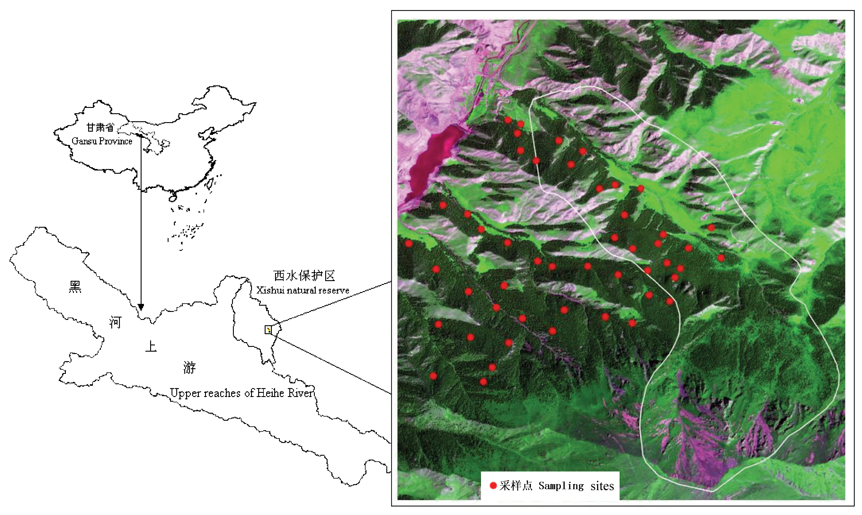
图1 研究区在西水自然保护区的相对位置和采样点的分布
Fig. 1 Location of study area in Xishui natural reserve and distribution of sampling sites
| 样方号 No. of sample | 坡度 Slope (°) | 经度Longitude (E) | 纬度Latitude (N) | 坡向 Aspect (°) | 海拔 Altitude (m) | 株数 No. of plants (株·hm-2) | 树高 Height of trees (m) | 胸径DBH (cm) | 胸高断面积Basal area at DBH (cm2) | 冠层盖度Canopy gap fraction (%) |
|---|---|---|---|---|---|---|---|---|---|---|
| No. 1 | 30 | 100.28° | 38.55° | 25 | 2 655 | 1 350 | 9.84 | 7.41 | 172.56 | 68.98 |
| No. 2 | 27 | 100.29° | 38.54° | 30 | 2 835 | 2 475 | 9.44 | 7.13 | 159.85 | 77.02 |
| No. 3 | 25 | 100.30° | 38.54° | 12 | 2 889 | 2 225 | 7.78 | 7.20 | 162.93 | 80.34 |
| No. 4 | 21 | 100.30° | 38.54° | 8 | 3 005 | 2 200 | 7.04 | 7.23 | 164.28 | 71.70 |
| No. 5 | 22 | 100.30° | 38.54° | 18 | 3 106 | 825 | 6.88 | 2.49 | 19.47 | 57.01 |
| No. 6 | 34 | 100.30° | 38.54° | 355 | 3 260 | 375 | 5.21 | 2.43 | 18.56 | 22.15 |
表1 祁连山排露沟流域6个固定样方青海云杉林的林分特征
Table 1 Stand characterisitcs of Picea crassifolia forest in six sampling plots of Pailugou catchment on Qilian Mountains
| 样方号 No. of sample | 坡度 Slope (°) | 经度Longitude (E) | 纬度Latitude (N) | 坡向 Aspect (°) | 海拔 Altitude (m) | 株数 No. of plants (株·hm-2) | 树高 Height of trees (m) | 胸径DBH (cm) | 胸高断面积Basal area at DBH (cm2) | 冠层盖度Canopy gap fraction (%) |
|---|---|---|---|---|---|---|---|---|---|---|
| No. 1 | 30 | 100.28° | 38.55° | 25 | 2 655 | 1 350 | 9.84 | 7.41 | 172.56 | 68.98 |
| No. 2 | 27 | 100.29° | 38.54° | 30 | 2 835 | 2 475 | 9.44 | 7.13 | 159.85 | 77.02 |
| No. 3 | 25 | 100.30° | 38.54° | 12 | 2 889 | 2 225 | 7.78 | 7.20 | 162.93 | 80.34 |
| No. 4 | 21 | 100.30° | 38.54° | 8 | 3 005 | 2 200 | 7.04 | 7.23 | 164.28 | 71.70 |
| No. 5 | 22 | 100.30° | 38.54° | 18 | 3 106 | 825 | 6.88 | 2.49 | 19.47 | 57.01 |
| No. 6 | 34 | 100.30° | 38.54° | 355 | 3 260 | 375 | 5.21 | 2.43 | 18.56 | 22.15 |
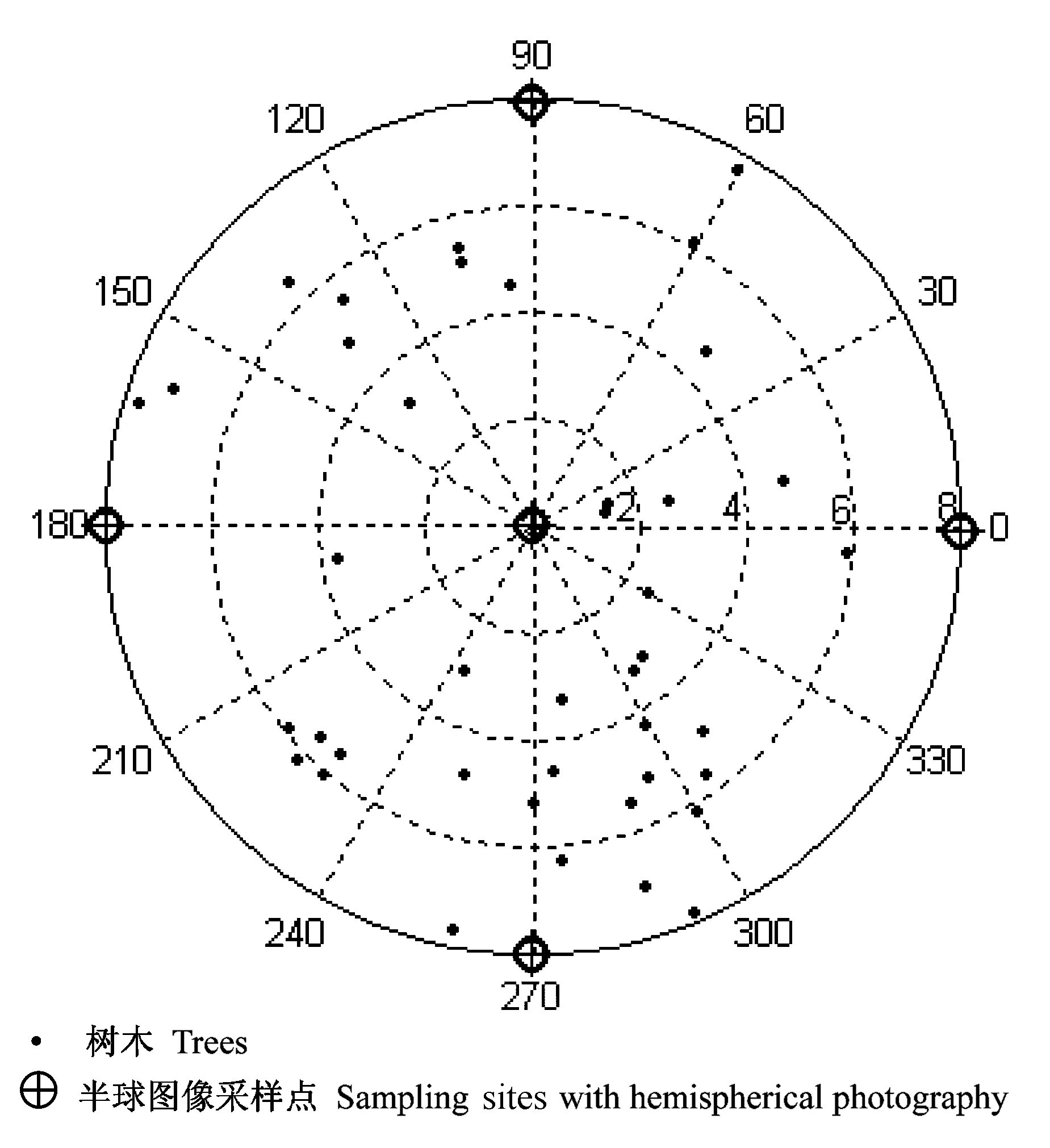
图2 35号样圆树木相对位置和半球图像获取位置图
Fig. 2 Relative positions of trees and sampling positions for hemispherical photography in the sampling plot 35
| 鱼眼镜头4环LAI平均值 Average LAI by Fisheyes 4R | 鱼眼镜头5环LAI平均值 Average LAI by Fisheyes 5R | 冠层分析仪4环LAI平均值 Average LAI by LAI-2000 4R | 冠层分析仪5环LAI平均值 Average LAI by LAI-2000 5R | 异速函数获得的LAI The LAI by allometric equation | |
|---|---|---|---|---|---|
| 鱼眼镜头4环LAI平均值 Average LAI by Fisheyes 4R | 1 | ||||
| 鱼眼镜头5环LAI平均值 Average LAI by Fisheyes 5R | 0.99 | 1 | |||
| 冠层分析仪4环LAI平均值 Average LAI by LAI-2000 4R | 0.28 | 0.29 | 1 | ||
| 冠层分析仪5环LAI平均值 Average LAI by LAI-2000 5R | 0.25 | 0.25 | 0.95 | 1 | |
| 异速函数获得的LAI The LAI by allometric equation | 0.69 | 0.68 | 0.29 | 0.27 | 1 |
表2 鱼眼镜头、LAI-2000冠层分析仪和异速函数测定的林冠层叶面积指数的相关系数(r)
Table 2 Correlation coefficients (r) between leaf area index (LAI) of canopy obtained by fisheyes, LAI-2000 canopy analyzer and allometric equation
| 鱼眼镜头4环LAI平均值 Average LAI by Fisheyes 4R | 鱼眼镜头5环LAI平均值 Average LAI by Fisheyes 5R | 冠层分析仪4环LAI平均值 Average LAI by LAI-2000 4R | 冠层分析仪5环LAI平均值 Average LAI by LAI-2000 5R | 异速函数获得的LAI The LAI by allometric equation | |
|---|---|---|---|---|---|
| 鱼眼镜头4环LAI平均值 Average LAI by Fisheyes 4R | 1 | ||||
| 鱼眼镜头5环LAI平均值 Average LAI by Fisheyes 5R | 0.99 | 1 | |||
| 冠层分析仪4环LAI平均值 Average LAI by LAI-2000 4R | 0.28 | 0.29 | 1 | ||
| 冠层分析仪5环LAI平均值 Average LAI by LAI-2000 5R | 0.25 | 0.25 | 0.95 | 1 | |
| 异速函数获得的LAI The LAI by allometric equation | 0.69 | 0.68 | 0.29 | 0.27 | 1 |
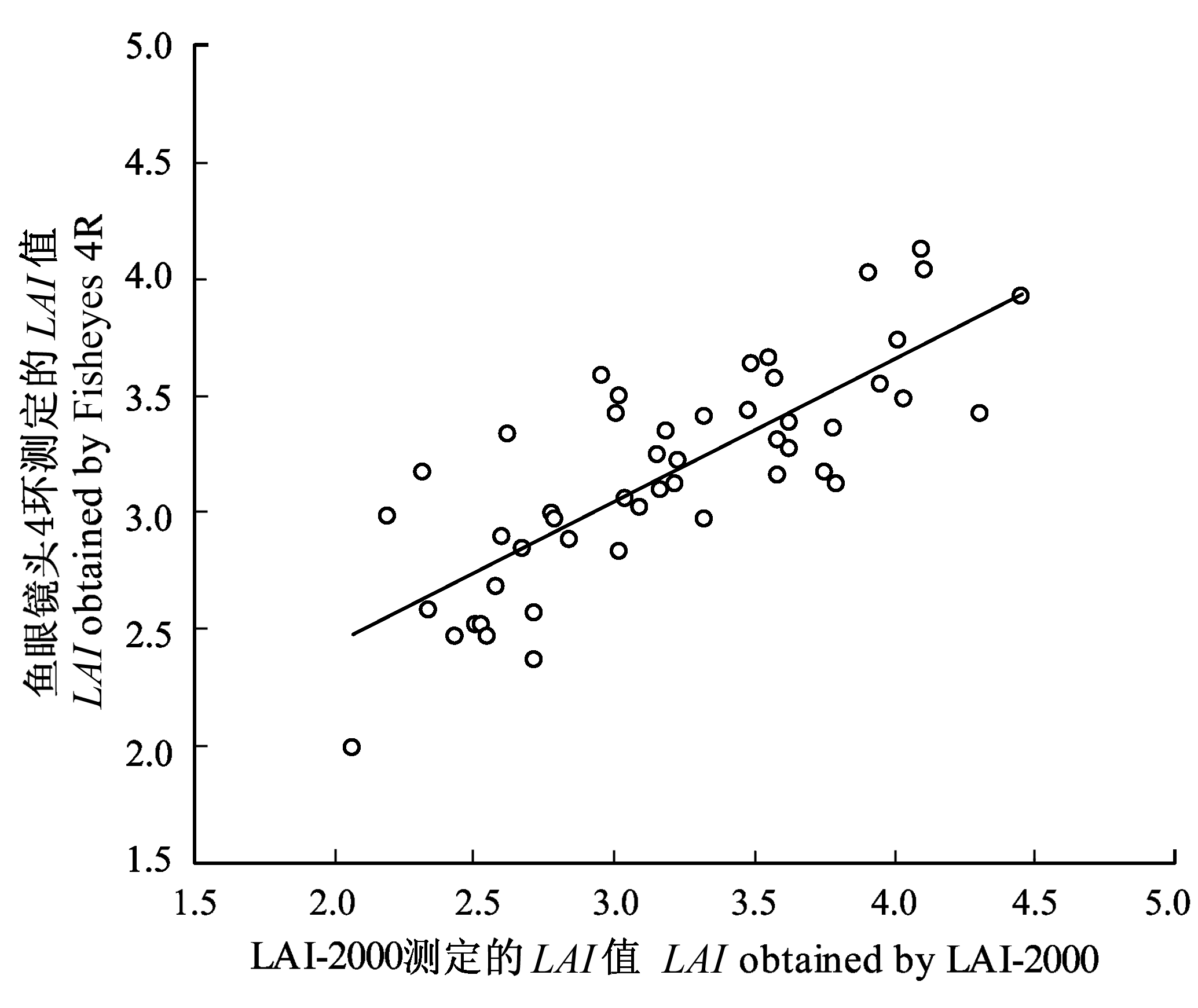
图3 LAI-2000冠层分析仪与鱼眼镜头4环测定的青海 云杉林林冠层叶面积指数(LAI)值散点图
Fig. 3 Scatter plot of the values of canopy leaf area index (LAI) of the Picea crassifolia forest obtained by LAI-2000 canopy analyzer and Fisheyes 4R
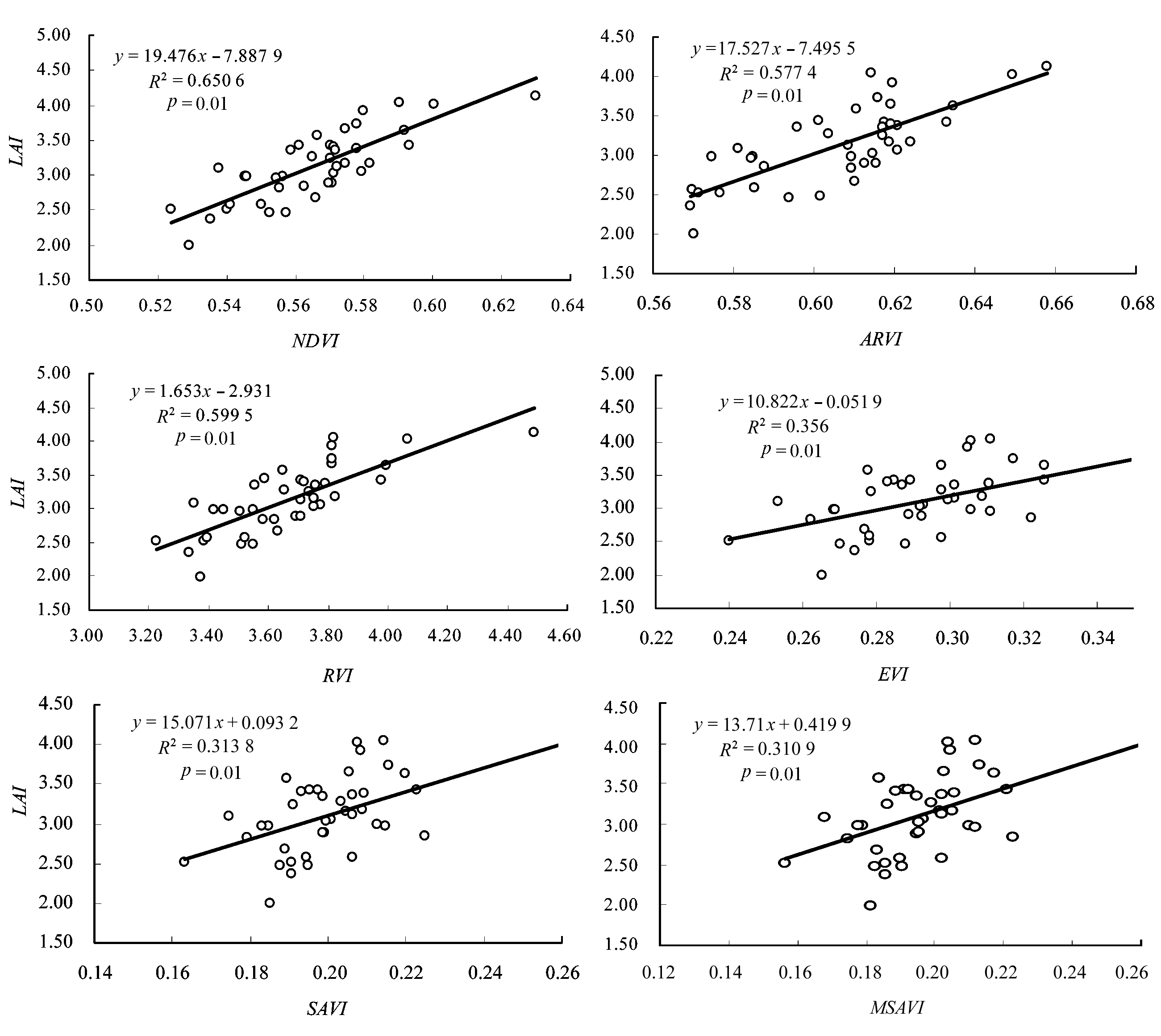
图4 青海云杉林林冠层鱼眼镜头获得的叶面积指数(LAI)与各植被指数的散点图 NDVI: 归一化植被指数 Normalized difference vegetation index RVI: 比值植被指数 Ratio vegetation index ARVI: 大气阻抗植被指数 Atmospherically resistant vegetation index MSAVI: 修正的土壤调节植被指数 Modified soil-adjusted vegetation index EVI: 改进型植被指数 Enhanced vegetation index SAVI: 土壤调节植被指数 Soil- adjusted vegetation index
Fig. 4 Scatter plots between canopy leaf area index (LAI) of the Picea crassifolia forest obtained by Fisheyes and six kinds of vegetation indexes
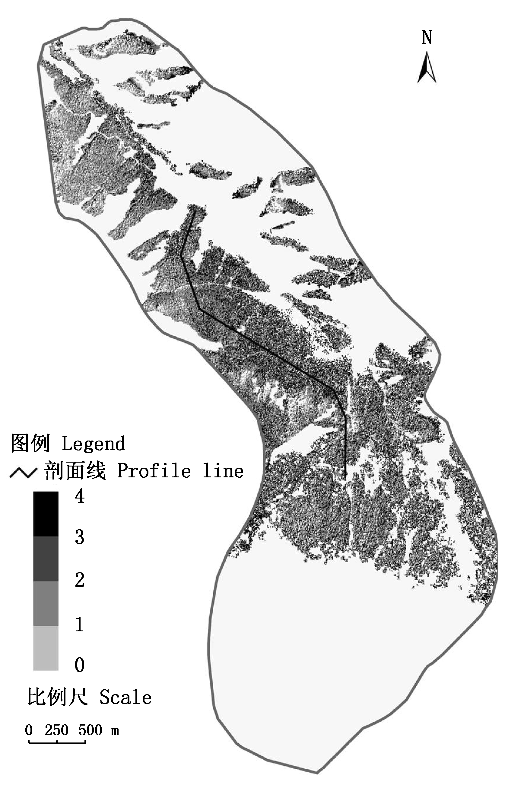
图5 研究区青海云杉林冠层叶面积指数(LAI)空间分布
Fig. 5 Spatial distribution of canopy leaf area index (LAI) of the Picea crassifolia forest in the study area
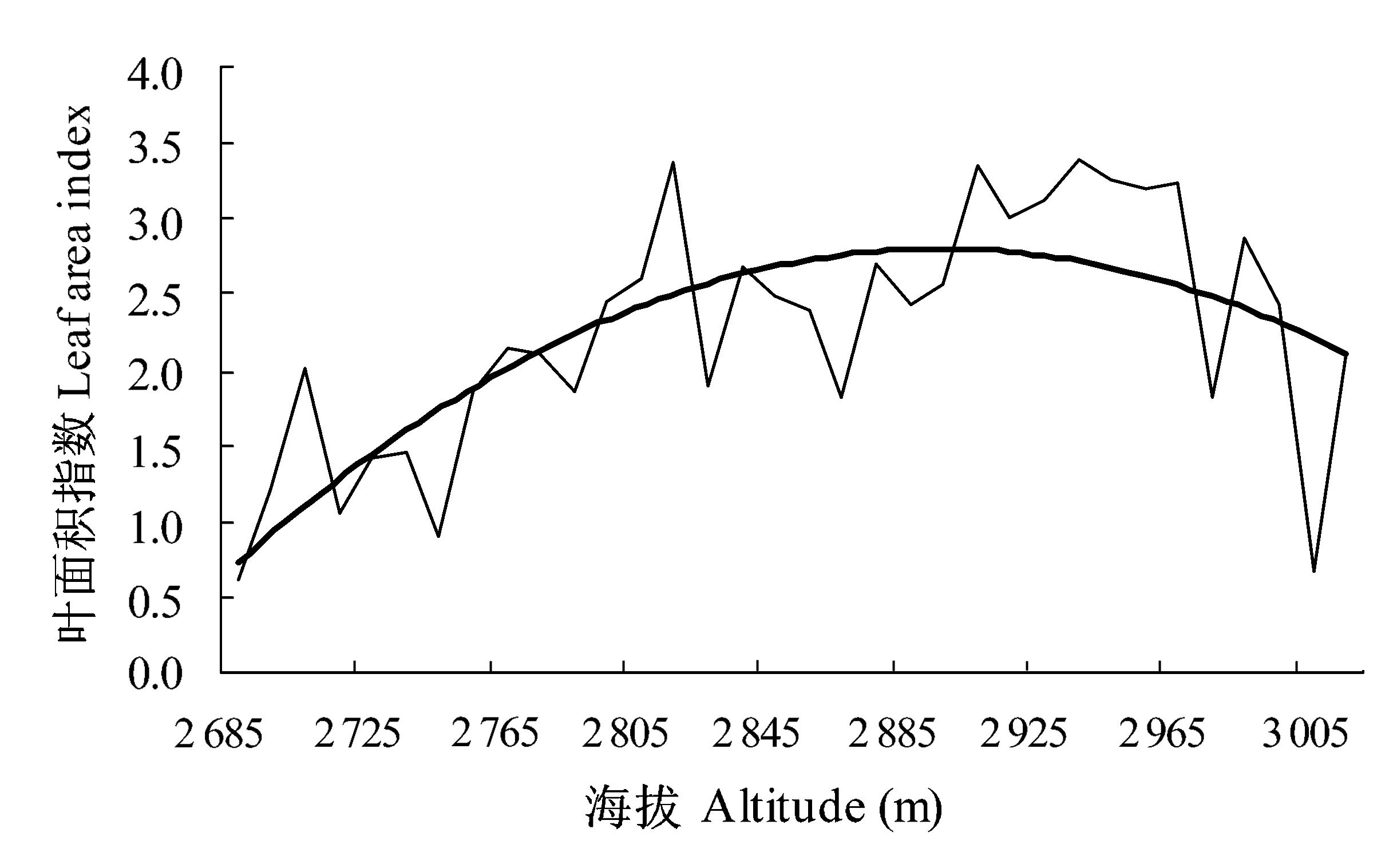
图6 研究区青海云杉林冠层叶面积指数(LAI)随海拔 高度的变化 粗线为叶面积指数的变化趋势线; 细线为叶面积指数的变化曲线 The thick line represents the trendline of LAI variation with the increase of altitude; The fine line represents the variation of LAI with the increase of altitude
Fig. 6 Variation of canopy leaf area index (LAI) of the Picea crassifolia forest in the study area with the increase of altitude
| [1] | Abduwasit Ghulam (阿布都瓦斯提·吾拉木), Qin QM (秦其明), Zhu LJ (朱黎江) (2004). 6S model based atmospheric correction of visible and near 2 infrared data and sensitivity analysis. Acta Scientiarum Naturalium Universitatis Pekinensis (北京大学学报自然科学版), 40, 611-618. (in Chinese with English abstract) |
| [2] |
Beaudet M, Messier C (2002). Variation in canopy openness and light transmission following selection cutting in northern hardwood stands: an assessment based on hemispherical photographs. Agricultural and Forest Meteorology, 110, 217-228.
DOI URL |
| [3] |
Bonan GB (1995). Land-atmosphere interactions for climate system models: coupling biophysical, biogeochemical, and ecosystem dynamical processes. Remote Sensing of Environment, 51, 57-73.
DOI URL |
| [4] | Chang XX (常学向), Che KJ (车克钧), Song CF (宋彩福) (1996). Preliminary studies on the biomass of Picea crassifolia forest community in Qilian Mountains. Journal of Northwest Forestry College (西北林学院学报), 11, 19-23. (in Chinese with English abstract) |
| [5] | Chang XX (常学向), Zhao AF (赵爱芬), Wang JY (王金叶), Chang ZQ (常宗强), Jin BW (金博文) (2002). Precipitation characteristic and interception of forest in Qilian Mountains. Plateau Meteorology (高原气象), 21, 274-280. (in Chinese with English abstract) |
| [6] |
Chen JM (1996). Optically-based methods for measuring seasonal variation of leaf area index in boreal conifer stands. Agricultural and Forest Meteorology, 80, 135-163.
DOI URL |
| [7] | Chen JM, Black TA (1992). Defining leaf area index for non-flat leaves. Plant, Cell and Environment, 15, 421-429. |
| [8] |
Chen JM, Cihlar J (1995). Quantifying the effect of canopy architecture on optical measurements of leaf area index using two gap size analysis methods. IEEE Transactions on Geoscience and Remote Sensing, 33, 777-787.
DOI URL |
| [9] |
Chen JM, Cihlar J (1996). Retrieving leaf area index of boreal conifer forest using Landsat TM images. Remote Sensing of Environment, 55, 153-162.
DOI URL |
| [10] |
Chen JM, Rich PM, Gower ST, Norman JM, Plummer S (1997). Leaf area index of boreal forests: theory, techniques, and measurements. Journal of Geophysical Research, 102(D24), 29429-29443.
DOI URL |
| [11] |
Gardingen PR, Jackson GE, Hernandez-Daumas S, Russell G, Sharp L (1999). Leaf area index estimates obtained for clumped canopies using hemispherical photography. Agricultural and Forest Meteorology, 94, 243-257.
DOI URL |
| [12] |
Gower ST, Kucharik CJ, Norman JM (1999). Direct and indirect estimation of leaf area index, fapar, and net primary production of terrestrial ecosystems. Remote Sensing of Environment, 70, 29-51.
DOI URL |
| [13] |
Hanan NP, Bégué A (1995). A method to estimate instantaneous and daily intercepted photosynthetically active radiation using a hemispherical sensor. Agricultural and Forest Meteorology, 74, 155-168.
DOI URL |
| [14] | Hu JM (胡金明), Deng W (邓伟), Xia BC (夏佰成) (2005). Application of LASCAM in study on the ecohydrological processes of catchment. Scientia Geographica Sinica (地理科学), 25, 427-433. (in Chinese with English abstract) |
| [15] |
Jonckheere I, Fleck S, Nackaerts K, Muys B, Coppin P, Weiss M, Baret F (2004). Review of methods for in situ leaf area index determination. Part I. Theories, sensors and hemispherical photography. Agricultural and Forest Meteorology, 121(1-2), 19-35.
DOI URL |
| [16] | Kang ES (康尔泗), Cheng GD (程国栋), Lan YC (蓝永超) , Chen RS (陈仁升), Zhang JS (张济世) (2002). Application of a conceptual hydrological model in the runoff forecast of a mountainous watershed. Advances in Earth Science (地球科学进展), 17, 18-26. (in Chinese with English abstract) |
| [17] |
Kovacs JM, Flores-Verdugo F, Wang JF, Aspden LP (2004). Estimating leaf area index of a degraded mangrove forest using high spatial resolution satellite data. Aquatic Botany, 80, 13-22.
DOI URL |
| [18] | Liu XC (刘兴聪) (1992). Picea crassifolia (青海云杉). Lanzhou University Press, Lanzhou, 45-54. (in Chinese) |
| [19] | Ma ZQ (马泽清), Liu Q (刘琪), Zeng HQ (曾慧卿), Li XR (李轩然), Chen YR (陈永瑞), Lin YM (林耀明), Zhang SH (张时煌), Yang FT (杨风亭), Wang HQ (汪宏清) (2008). Estimation of leaf area index of planted forests in subtropical China by photogrammetry. Acta Ecologica Sinica (生态学报), 28, 1971-1980. (in Chinese with English abstract) |
| [20] |
Martin W, Fred H, Reinhard W, Frank W, Valentina K, Franz B (2005). A simplified approach to implement forest eco-hydrological properties in regional hydrological modelling. Ecological Modelling, 187, 40-59.
DOI URL |
| [21] |
Planchais I, Pontailler JY (1999). Validity of leaf areas and angles estimated in a beech forest from analysis of gap frequencies, using hemispherical photographs and a plant canopy analyser. Annals of Forest Science, 56, 1-10.
DOI URL |
| [22] |
Running SW, Nemani RR, Peterson DL, Band LE, Potts DF, Pierce LL, Spanner MA (1989). Mapping regional forest evapotranspiration and photosynthesis by coupling satellite data with ecosystem simulation. Ecology, 70, 1090-1101.
DOI URL |
| [23] | Sun PS (孙鹏森), Liu SR (刘世荣), Liu JT (刘京涛), Li CW (李崇巍), Lin Y (林勇), Jiang H (江洪) (2006). Derivation and validation of leaf area index maps using NDVI data of different resolution satellite images. Acta Ecologica Sinica (生态学报), 26, 3826-3834. (in Chinese with English abstract) |
| [24] | Tan YB (谭一波), Zhao ZH (赵仲辉) (2008). The main methods for determining leaf area index. Forest Inventory and Planning (林业调查规划), 33(3), 45-48. (in Chinese with English abstract) |
| [25] |
Tian Q, Luo Z, Chen JM, Chenc M, Hui F (2007). Retrieving leaf area index for coniferous forest in Xingguo County, China with Landsat ETM + images. Journal of Environmental Management, 85, 624-627.
DOI URL |
| [26] |
Turner DP, Cohen WB, Kennedy RE, Fassnacht KS, Briggs JM (1999). Relationships between leaf area index, fPAR, and net primary production of terrestrial ecosystems. Remote Sensing of Environment, 70, 52-68.
DOI URL |
| [27] |
Veroustraete F, Patyn J, Myneni RB (1996). Estimating net ecosystem exchange of carbon using the normalized difference vegetation index and an ecosystem model. Remote Sensing of Environment, 58, 115-130.
DOI URL |
| [28] |
Wang P, Sun R, Hu J, Zhu Q, Zhou Y, Li L, Chen JM (2007). Measurements and simulation of forest leaf area index and net primary productivity in Northern China. Journal of Environmental Management, 85, 607-615.
DOI URL |
| [29] | Wang SL (王顺利), Wang JY (王金叶), Zhang XL (张学龙), Jing WM (敬文茂) (2006). Distribution of withered litters of moss and hydrographic characteristics in the Picea crassifolia forest on Qilian Mountain. Research of Soil and Water Conservation (水土保持研究), 13(5), 156-159. (in Chinese with English abstract) |
| [30] | Wang XQ (王希群), Ma LY (马履一), Jia ZK (贾忠奎), Xu CY (徐程扬) (2005). Research and application advances in leaf area index (LAI). Chinese Journal of Ecology (生态学杂志), 24, 537-541. (in Chinese with English abstract) |
| [31] |
Watson FGR, Grayson RB, Vertessy RA, McMahon TA (1998). Large scale distribution modeling and the utility of detailed ground data. Hydrological Processes, 12, 873-888.
DOI URL |
| [32] |
Weiss M, Baret F, Smith GJ, Jonckheere I, Coppin P (2004). Review of methods for in situ leaf area index (LAI) determination. Part II. Estimation of LAI, errors and sampling. Agricultural and Forest Meteorology, 121, 37-53.
DOI URL |
| [33] |
White MA, Asner GP, Nemani RR, Privette JL, Running SW (2000). Measuring fractional cover and leaf area index in arid ecosystems: digital camera, radiation transmittance, and laser altimetry methods. Remote Sensing of Environments, 74, 45-57.
DOI URL |
| [34] |
Xia J (夏军), Wang GS (王纲胜), Lü AF (吕爱锋), Tan G (谈戈) (2003). A research on distributed time variant gain modeling. Acta Geographica Sinica (地理学报), 58, 789-796. (in Chinese with English abstract)
DOI URL |
| [35] | Zhang H (张虎), Wen YL (温娅丽), Ma L (马力), Chang ZQ (常宗强), Wang JY (王金叶) (2001). The climate features and regionalization of vertical climatic zones in the northern slope of Qilian Mountains. Journal of Mountains Science (山地学报), 19, 497-502. (in Chinese with English abstract) |
| [36] | Zhou YY (周宇宇), Tang SH (唐世浩), Zhu QJ (朱启疆), Li JT (李江涛), Sun R (孙睿), Liu SH (刘素红) (2003). Measurement of LAI in Changbai Mountains Nature Reserve and its result. Resources Science (资源科学), 25(6), 38-42. (in Chinese with English abstract) |
| [1] | 赵长兴, 赵维俊, 张兴林, 刘思敏, 牟文博, 刘金荣. 祁连山排露沟流域青海云杉种群种内竞争与促进作用分析[J]. 植物生态学报, 2022, 46(9): 1027-1037. |
| [2] | 秦慧君, 焦亮, 周怡, 薛儒鸿, 柒常亮, 杜达石. 祁连山优势树木碳水化合物资源分配的海拔和树种效应[J]. 植物生态学报, 2022, 46(2): 208-219. |
| [3] | 杜军, 王文, 何志斌, 陈龙飞, 蔺鹏飞, 朱喜, 田全彦. 祁连山青海云杉物候表型的空间分异及其内在机制[J]. 植物生态学报, 2021, 45(8): 834-843. |
| [4] | 拓锋, 刘贤德, 刘润红, 赵维俊, 敬文茂, 马剑, 武秀荣, 赵晶忠, 马雪娥. 祁连山大野口流域青海云杉种群空间格局及其关联性[J]. 植物生态学报, 2020, 44(11): 1172-1183. |
| [5] | 杨军军, 封建民, 何志斌. 基于热比率法的青海云杉林蒸腾量估算[J]. 植物生态学报, 2018, 42(2): 195-201. |
| [6] | 彭守璋, 赵传燕, 许仲林, 王超, 柳逸月. 黑河上游祁连山区青海云杉生长状况及其潜在分布区的模拟[J]. 植物生态学报, 2011, 35(6): 605-614. |
| [7] | 张鹏, 王刚, 张涛, 陈年来. 祁连山两种优势乔木叶片δ13C的海拔响应及其机理[J]. 植物生态学报, 2010, 34(2): 125-133. |
| [8] | 张涛, 安黎哲, 陈拓, 代春艳, 陈年来. 不同海拔青海云杉与祁连圆柏叶片抗氧化系统[J]. 植物生态学报, 2009, 33(4): 802-811. |
| [9] | 王娅丽, 李毅. 祁连山青海云杉天然群体的种实性状表型多样性[J]. 植物生态学报, 2008, 32(2): 355-362. |
| 阅读次数 | ||||||
|
全文 |
|
|||||
|
摘要 |
|
|||||
Copyright © 2022 版权所有 《植物生态学报》编辑部
地址: 北京香山南辛村20号, 邮编: 100093
Tel.: 010-62836134, 62836138; Fax: 010-82599431; E-mail: apes@ibcas.ac.cn, cjpe@ibcas.ac.cn
备案号: 京ICP备16067583号-19