
植物生态学报 ›› 2005, Vol. 29 ›› Issue (6): 934-944.DOI: 10.17521/cjpe.2005.0115 cstr: 32100.14.cjpe.2005.0115
喻锋1,2, 李晓兵1,*( ), 王宏1, 余弘婧1, 陈云浩1
接受日期:2004-09-21
发布日期:2005-09-30
作者简介:*E-mail:xbli@ires.cn基金资助:
YU Feng1,2, LI Xiao-Bing1,*(), WANG Hong1, YU Hong-Jing1, CHEN Yun-Hao1
Accepted:2004-09-21
Published:2005-09-30
摘要:
归一化植被指数(NDVI)与地表温度(Ts)是描述地表覆盖特征的两个重要参数,其构成的NDVI-Ts特征空间具有丰富的地学和生态学内涵。该文在NOAA/AVHRR连续时间序列数据反演Ts的基础上,通过主成分分析、非监督分类和基于DEM的分类后处理等方法,以Ts/NDVI为指标对中国土地覆盖进行分类。结果表明,Ts/NDVI对中国较大尺度上不同土地覆盖类型的差异具有较强的敏感性,其对中国土地覆盖分类结果的野外抽样检验精度比传统的单独利用NDVI时间序列进行非监督分类提高了3.3%,Kappa系数提高了0.020 2;在综合其它反映植被特征及其环境的指标(如气候、地形等)的基础上,利用Ts/NDVI将有可能较为准确地提取中国植被或土地覆盖的信息,有利于对其进行分类和变化监测,具有深远的研究潜力和应用价值。
喻锋, 李晓兵, 王宏, 余弘婧, 陈云浩. 基于NDVI-Ts特征空间的中国土地覆盖分类研究. 植物生态学报, 2005, 29(6): 934-944. DOI: 10.17521/cjpe.2005.0115
YU Feng, LI Xiao-Bing, WANG Hong, YU Hong-Jing, CHEN Yun-Hao. LAND COVER CLASSIFICATION IN CHINA BASED ON THE NDVI-T<sub>S</sub> FEATURE SPACE. Chinese Journal of Plant Ecology, 2005, 29(6): 934-944. DOI: 10.17521/cjpe.2005.0115
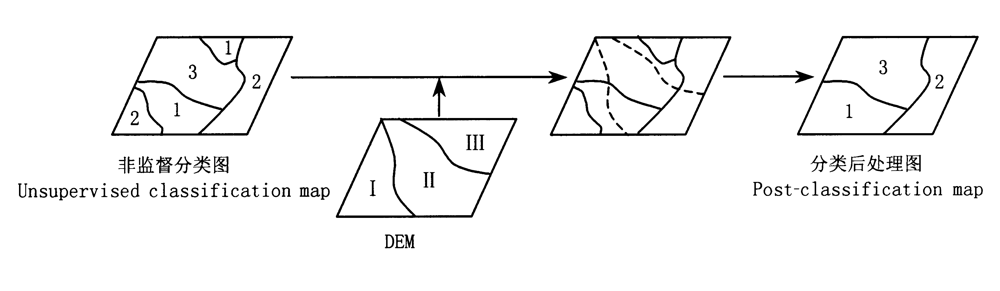
图1 基于DEM的分类后处理
Fig.1 Post-classification based on DEM
| 主成分 Principal component | NDVI、Ts和Ts/NDVI主成分变换特征向量 Eigenvectors of principal components for NDVI,Ts and Ts/NDVI | 方差(%) Expressed variance | ||||||||||||||||||
|---|---|---|---|---|---|---|---|---|---|---|---|---|---|---|---|---|---|---|---|---|
| 1 | 2 | 3 | 4 | 5 | 6 | 7 | 8 | 9 | 10 | 11 | 12 | |||||||||
| NDVI | PC1 | 0.26 | 0.26 | 0.27 | 0.27 | 0.29 | 0.31 | 0.32 | 0.32 | 0.31 | 0.29 | 0.28 | 0.27 | 81 | ||||||
| PC2 | 0.25 | 0.32 | 0.36 | 0.13 | -0.12 | -0.33 | -0.40 | -0.37 | -0.26 | 0.05 | 0.25 | 0.37 | 14.7 | |||||||
| PC3 | -0.44 | -0.15 | 0.07 | -0.54 | -0.08 | 0.31 | -0.05 | -0.17 | 0.01 | 0.36 | 0.36 | 0.29 | 1.5 | |||||||
| PC4 | -0.05 | -0.14 | -0.16 | 0.29 | 0.67 | 0.35 | -0.22 | -0.41 | -0.25 | 0.04 | 0.03 | -0.13 | 1.4 | |||||||
| Ts | PC1 | 0.13 | 0.19 | 0.25 | 0.32 | 0.36 | 0.37 | 0.36 | 0.36 | 0.33 | 0.28 | 0.20 | 0.15 | 96.5 | ||||||
| PC2 | -0.52 | -0.41 | -0.21 | 0.01 | 0.17 | 0.23 | 0.23 | 0.20 | 0.11 | -0.04 | -0.29 | -0.49 | 3.0 | |||||||
| Ts/NDVI | PC1 | 0.13 | 0.19 | 0.27 | 0.33 | 0.37 | 0.37 | 0.36 | 0.35 | 0.32 | 0.28 | 0.20 | 0.15 | 96.3 | ||||||
| PC2 | -0.54 | -0.43 | -0.20 | -0.01 | 0.15 | 0.21 | 0.24 | 0.22 | 0.13 | -0.01 | -0.27 | -0.47 | 2.8 | |||||||
表1 NDVI、Ts和Ts/NDVI主成分分析的荷载因子矩阵
Table 1 Factor loading matrix of principal component analysis for NDVI, Ts and Ts/NDVI
| 主成分 Principal component | NDVI、Ts和Ts/NDVI主成分变换特征向量 Eigenvectors of principal components for NDVI,Ts and Ts/NDVI | 方差(%) Expressed variance | ||||||||||||||||||
|---|---|---|---|---|---|---|---|---|---|---|---|---|---|---|---|---|---|---|---|---|
| 1 | 2 | 3 | 4 | 5 | 6 | 7 | 8 | 9 | 10 | 11 | 12 | |||||||||
| NDVI | PC1 | 0.26 | 0.26 | 0.27 | 0.27 | 0.29 | 0.31 | 0.32 | 0.32 | 0.31 | 0.29 | 0.28 | 0.27 | 81 | ||||||
| PC2 | 0.25 | 0.32 | 0.36 | 0.13 | -0.12 | -0.33 | -0.40 | -0.37 | -0.26 | 0.05 | 0.25 | 0.37 | 14.7 | |||||||
| PC3 | -0.44 | -0.15 | 0.07 | -0.54 | -0.08 | 0.31 | -0.05 | -0.17 | 0.01 | 0.36 | 0.36 | 0.29 | 1.5 | |||||||
| PC4 | -0.05 | -0.14 | -0.16 | 0.29 | 0.67 | 0.35 | -0.22 | -0.41 | -0.25 | 0.04 | 0.03 | -0.13 | 1.4 | |||||||
| Ts | PC1 | 0.13 | 0.19 | 0.25 | 0.32 | 0.36 | 0.37 | 0.36 | 0.36 | 0.33 | 0.28 | 0.20 | 0.15 | 96.5 | ||||||
| PC2 | -0.52 | -0.41 | -0.21 | 0.01 | 0.17 | 0.23 | 0.23 | 0.20 | 0.11 | -0.04 | -0.29 | -0.49 | 3.0 | |||||||
| Ts/NDVI | PC1 | 0.13 | 0.19 | 0.27 | 0.33 | 0.37 | 0.37 | 0.36 | 0.35 | 0.32 | 0.28 | 0.20 | 0.15 | 96.3 | ||||||
| PC2 | -0.54 | -0.43 | -0.20 | -0.01 | 0.15 | 0.21 | 0.24 | 0.22 | 0.13 | -0.01 | -0.27 | -0.47 | 2.8 | |||||||
| 一、针叶林 Coniferous forest |
|---|
| 1.寒温带、温带落叶、常绿针叶林 Cold temperate and temperate deciduous and evergreen coniferous forest |
| 2.亚热带、热带常绿针叶林 Subtropical and tropical evergreen coniferous forest |
| 二、阔叶林 Broad-leaf forest |
| 3.温带、亚热带落叶阔叶林 Temperate and subtropical deciduous broad-leaf forest |
| 4.亚热带落叶阔叶、常绿阔叶混交林 Subtropical deciduous and evergreen broad-leaf forest |
| 5.亚热带常绿阔叶林 Subtropical evergreen broad-leaf forest |
| 6.热带雨林性阔叶林及次生植被 Tropical rain broad-leaf forest and secondary vegetation |
| 三、灌丛和萌生矮林 Shrub and sprouting dwarf-forest |
| 7.温带、亚热带落叶灌丛、矮林 Temperate and subtropical deciduous shrub and sprouting dwarf-forest |
| 8.亚热带、热带常绿、落叶阔叶灌丛、矮林和草甸Subtropical and tropical evergreen and deciduous broad-leaf shrub, dwarf-forest and meadow |
| 9.温带、亚热带高山矮半灌木、草本植被 Temperate and subtropical alpine dwarf semi-shrub and meadow vegetation |
| 四、荒漠 Desert |
| 10.温带矮半灌木荒漠 Temperate dwarf semi-shrub desert |
| 11.温带灌木、半灌木荒漠 Temperate shrub and semi-shrub desert |
| 12.温带半乔木荒漠 Temperate semi-arbor desert |
| 13.温带高寒矮半灌木荒漠 Temperate cold semi-shrub desert |
| 五、草原和稀树灌木草原 Steppe and savanna |
| 14.温带禾草、杂类草草原 Temperate grass and forbs steppe |
| 15.温带丛生禾草草原 Temperate bunchgrass steppe |
| 16.温带矮禾草、矮半灌木草原 Temperate dwarf-grass and dwarf semi-shrub steppe |
| 17.温带、亚热带高寒草原 Temperate and subtropical cold steppe |
| 六、草甸和草本沼泽 Meadow and herbaceous swamp |
| 18.温带草甸 Temperate meadow |
| 19.温带、亚热带高寒草甸 Temperate and subtropical cold meadow |
| 20.温带草本沼泽 Temperate herbaceous swamp |
| 七、人工栽培植被 Artificial cultivated vegetation |
| 21.一年一熟粮作和耐寒经济作物 One crop per year and hardy economic crop |
| 22.一年两熟或两年三熟旱作(局部水稻)和暖温带落叶果树园,经济林 Two dryland crop per year or three dryland crop per two years(paddy locally), temperate deciduous fruit forest and economic forest |
| 23.一年水旱两熟粮作和亚热带常绿、落叶经济林、果树园 Two crop per year alternate paddy and dryland, subtropical evergreen and deciduous economic forest and fruit forest |
| 24.单(双)季稻连作喜凉旱作或一年三熟旱作和亚热带常绿经济林、果树园 Single(double)-harvest rice with successive cropping, cryophilous dryland crop or three dryland crop per year, subtropical evergreen economic forest and fruit forest |
| 25.双季稻或双季稻连作喜温旱作和热作常绿经济林、果树园 Double-harvest rice or with successive cropping, thermophilic dryland crop, tropical evergreen economic forest and fruit forest |
| 八、无植被地段 Region without vegetation |
| 26.无植被地段 Region without vegetation |
| 九、湖泊 Lake |
| 27.湖泊 Lake |
表2 中国土地覆盖分类表
Table 2 Land cover classification list in China
| 一、针叶林 Coniferous forest |
|---|
| 1.寒温带、温带落叶、常绿针叶林 Cold temperate and temperate deciduous and evergreen coniferous forest |
| 2.亚热带、热带常绿针叶林 Subtropical and tropical evergreen coniferous forest |
| 二、阔叶林 Broad-leaf forest |
| 3.温带、亚热带落叶阔叶林 Temperate and subtropical deciduous broad-leaf forest |
| 4.亚热带落叶阔叶、常绿阔叶混交林 Subtropical deciduous and evergreen broad-leaf forest |
| 5.亚热带常绿阔叶林 Subtropical evergreen broad-leaf forest |
| 6.热带雨林性阔叶林及次生植被 Tropical rain broad-leaf forest and secondary vegetation |
| 三、灌丛和萌生矮林 Shrub and sprouting dwarf-forest |
| 7.温带、亚热带落叶灌丛、矮林 Temperate and subtropical deciduous shrub and sprouting dwarf-forest |
| 8.亚热带、热带常绿、落叶阔叶灌丛、矮林和草甸Subtropical and tropical evergreen and deciduous broad-leaf shrub, dwarf-forest and meadow |
| 9.温带、亚热带高山矮半灌木、草本植被 Temperate and subtropical alpine dwarf semi-shrub and meadow vegetation |
| 四、荒漠 Desert |
| 10.温带矮半灌木荒漠 Temperate dwarf semi-shrub desert |
| 11.温带灌木、半灌木荒漠 Temperate shrub and semi-shrub desert |
| 12.温带半乔木荒漠 Temperate semi-arbor desert |
| 13.温带高寒矮半灌木荒漠 Temperate cold semi-shrub desert |
| 五、草原和稀树灌木草原 Steppe and savanna |
| 14.温带禾草、杂类草草原 Temperate grass and forbs steppe |
| 15.温带丛生禾草草原 Temperate bunchgrass steppe |
| 16.温带矮禾草、矮半灌木草原 Temperate dwarf-grass and dwarf semi-shrub steppe |
| 17.温带、亚热带高寒草原 Temperate and subtropical cold steppe |
| 六、草甸和草本沼泽 Meadow and herbaceous swamp |
| 18.温带草甸 Temperate meadow |
| 19.温带、亚热带高寒草甸 Temperate and subtropical cold meadow |
| 20.温带草本沼泽 Temperate herbaceous swamp |
| 七、人工栽培植被 Artificial cultivated vegetation |
| 21.一年一熟粮作和耐寒经济作物 One crop per year and hardy economic crop |
| 22.一年两熟或两年三熟旱作(局部水稻)和暖温带落叶果树园,经济林 Two dryland crop per year or three dryland crop per two years(paddy locally), temperate deciduous fruit forest and economic forest |
| 23.一年水旱两熟粮作和亚热带常绿、落叶经济林、果树园 Two crop per year alternate paddy and dryland, subtropical evergreen and deciduous economic forest and fruit forest |
| 24.单(双)季稻连作喜凉旱作或一年三熟旱作和亚热带常绿经济林、果树园 Single(double)-harvest rice with successive cropping, cryophilous dryland crop or three dryland crop per year, subtropical evergreen economic forest and fruit forest |
| 25.双季稻或双季稻连作喜温旱作和热作常绿经济林、果树园 Double-harvest rice or with successive cropping, thermophilic dryland crop, tropical evergreen economic forest and fruit forest |
| 八、无植被地段 Region without vegetation |
| 26.无植被地段 Region without vegetation |
| 九、湖泊 Lake |
| 27.湖泊 Lake |
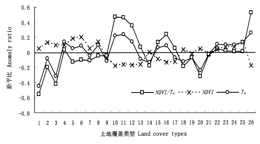
图3 各土地覆盖类型NDVI、Ts和Ts/NDVI的距平比 1~26:同表2
Fig.3 Anomaly ratios of NDVI,Ts and Ts/NDVI to various land cover types See Table 2
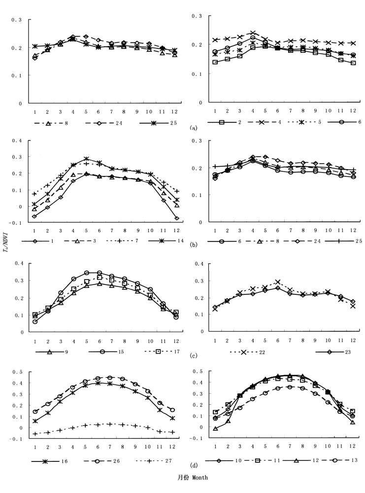
图4 各种土地覆盖类型Ts/NDVI季节变化曲线 1~17, 22~27:同表2
Fig.4 The seasonal variation curves of Ts/NDVI to various land cover categories See Table 2
| 分类指标 Index for classification | GPS取样区 Sampling area for GPS spots | 总点数 Number of total spots | 正确点 Number of correct | 错(混)分点 Number of incongruous (mixed) | 精度 Accuracy(%) |
|---|---|---|---|---|---|
| Ts/NDVI | 海南地区 Hainan region | 79 | 50 | 29 | 63.3 |
| 内蒙古地区 Inner Mongolia region | 219 | 163 | 56 | 74.4 | |
| 新疆地区 Xinjiang region | 282 | 201 | 81 | 71.3 | |
| 东北地区 Northeast region | 87 | 66 | 21 | 75.9 | |
| 整个研究区 The whole study region | 667 | 480 | 187 | 72.0 | |
| NDVI | 海南地区 Hainan region | 79 | 54 | 25 | 68.4 |
| 内蒙古地区 Inner Mongolia region | 219 | 152 | 67 | 69.4 | |
| 新疆地区 Xinjiang region | 282 | 192 | 90 | 68.1 | |
| 东北地区 Northeast region | 87 | 60 | 27 | 69.0 | |
| 整个研究区 The whole study region | 667 | 458 | 209 | 68.7 |
表3 分类结果野外抽样检验表
Table 3 Field spot check list of classification
| 分类指标 Index for classification | GPS取样区 Sampling area for GPS spots | 总点数 Number of total spots | 正确点 Number of correct | 错(混)分点 Number of incongruous (mixed) | 精度 Accuracy(%) |
|---|---|---|---|---|---|
| Ts/NDVI | 海南地区 Hainan region | 79 | 50 | 29 | 63.3 |
| 内蒙古地区 Inner Mongolia region | 219 | 163 | 56 | 74.4 | |
| 新疆地区 Xinjiang region | 282 | 201 | 81 | 71.3 | |
| 东北地区 Northeast region | 87 | 66 | 21 | 75.9 | |
| 整个研究区 The whole study region | 667 | 480 | 187 | 72.0 | |
| NDVI | 海南地区 Hainan region | 79 | 54 | 25 | 68.4 |
| 内蒙古地区 Inner Mongolia region | 219 | 152 | 67 | 69.4 | |
| 新疆地区 Xinjiang region | 282 | 192 | 90 | 68.1 | |
| 东北地区 Northeast region | 87 | 60 | 27 | 69.0 | |
| 整个研究区 The whole study region | 667 | 458 | 209 | 68.7 |
| [1] | Becker F, Li ZL (1990). Towards a local split window method over land surface. International Journal of Remote Sensing, 11,369-393. |
| [2] | Carpenter GA, Gjaja MN, Gopal S, Woodcock CE (1997). ART neural networks for remote sensing: vegetation classification from Landsat TM and terrain data. IEEE Transactions on Geoscience and Remote Sensing, 35,308-325. |
| [3] | Chen YH (陈云浩), Li XB (李晓兵), Shi PJ (史培军), Dou W (窦闻), Li X (李霞) (2003). Intra-annual vegetation change characteristics in the NDVI-T s space application to Farming-Pastoral Zone in North China. Acta Botanica Sinica (植物学报), 45,1139-1145. (in Chinese with English abstract) |
| [4] | Cihlar J, Xiao QH, Chen J, Beaubien J, Fung K, Latifovic R (1998). Classification by progressive generalization: a new automated methodology for remote sensing multichannel data. International Journal of Remote Sensing, 19,2685-2704. |
| [5] | Du MY (杜明义), Wu WB (武文波), Guo DZ (郭达志) (2002). Research on multi-source geographic information based classification of desertification. Journal of Image and Graphics (中国图象图形学报), 7,740-743. (in Chinese with English abstract) |
| [6] | Ehrlich D, Estes JE, Singh A (1994). Applications of NOAA-AVHRR 1 km data for environmental monitoring. International Journal of Remote Sensing, 15,145-161. |
| [7] | Foody GM (1998). Sharpening fuzzy classification output to refine the representation of sub-pixel land cover distribution. International Journal of Remote Sensing, 19,2593-2599. |
| [8] | Hansen M, Dubayah R, DeFries R (1996). Classification trees: an alternative to traditional land cover classifiers. International Journal of Remote Sensing, 17,1075-1081. |
| [9] | Holben BN (1986). Characteristics of maximum-value composite images for temporal AVHRR data. International Journal of Remote Sensing, 7,1435-1445. |
| [10] | Josef C, Ly H, Li QZ, Chen J, Hartely P, Huang FT (1997). Multitemporal, mulitichannel AVHRR data sets for land biosphere studies-artifacts and corrections. Remote Sensing of Environment, 60,35-57. |
| [11] | Lambin EF, Ehrlich D (1995). Combing vegetation indices and surface temperature for land-cover mapping at broad spatial scales. International Journal of Remote Sensing, 16,573-579. |
| [12] | Lambin EF, Ehrlich D (1996). The surface temperature-vegetation index space for land cover and land-cover change analysis. International Journal of Remote Sensing, 17,463-487. |
| [13] | Lambin EF, Ehrlich D (1997). Land-cover change in Sub-Saharan Africa (1982-1991): application of a change index based on remotely sensed surface temperature and vegetation indices at a continental scale. Remote Sensing of Environment, 61,181-200. |
| [14] | Land Processes Distributed Active Archive Center LPDAAC (2004). Global land cover characterization database. http://edcdaac.usgs.gov/glcc/.Cited 20 Jun 2004. |
| [15] | Lark RM (1995). A reappraisal of unsupervised classification Ⅱ. Optimal adjustment of the map legend and a neigbourhood approach for mapping legend units. International Journal of Remote Sensing, 16,1445-1460. |
| [16] | Li DF (李道峰), Tian Y (田英), Hao FH (郝芳华) (2003). NDVI data based study on complex classification of vegetation cover of Yellow River Basin. Research of Soil and Water Conservation (水土保持研究), 10,88-91. (in Chinese with English abstract) |
| [17] | Li XB (李晓兵), Chen YH (陈云浩), Yu F (喻锋) (2004). Global and regional cover mapping from remote sensing data: status quo, strategies and trends. Advance in Earth Sciences, 19(1),71-80. (in Chinese with English abstract) |
| [18] | Loveland TR, Merchant JW, Ohlen DO, Brown J (1991). Development of a land-cover database for the conterminous U.S. Photogrammetric Engineering and Remote Sensing, 57,1453-1463. |
| [19] | Meer F (1995). Spectral unmixing of landsat the matci mapper data. International Journal of Remote Sensing, 16,3189-3194. |
| [20] | NASA. Pathfinder Advanced Very High Resolution Radiometer(AVHRR) Land FTP Data (2004). http://daac.gsfc.nasa.gov/. Cited 20 Jun 2004. |
| [21] | Pan YZ (潘耀忠), Li XB (李晓兵), He CY (何春阳) (2000). Research on comprehensive land cover classification in China: Based on NOAA/AVHRR and Holdridge PE index. Quaternary Sciences (第四纪研究), 20,270-281. (in Chinese with English abstract) |
| [22] | Qin ZH (覃志豪), Arnon K (2001). Split window algorithms for retrieving land surface temperature from NOAA-AVHRR data. Remote Sensing for Land & Resources (国土资源遥感), 2,33-42. (in Chinese with English abstract) |
| [23] | Running SW, Loveland TR, Pierce LL, Nemani RR, Hunt ER (1995). A remote sensing based vegetation classification logic for global land cover analysis. Remote Sensing of Environment, 51,39-48. |
| [24] | Saunders RW, Kriebel KT (1988). An improved method for detecting clear sky and cloudy radiances from AVHRR data. International Journal of Remote Sensing, 9,123-150. |
| [25] | Townshend JR, Justice CO, Kalb V (1987). Characterization and classification of South American land cover types using satellite data. International Journal of Remote Sensing, 8,1189-1207. |
| [26] |
Tucker CJ, Townshend JR, Goff TE (1985). African land-cover classification using satellite data. Science, 227,369-375.
URL PMID |
| [27] | Wu ZY (吴征缢) (1980). Vegetation of China (中国植被). Science Press, Beijing. (in Chinese) |
| [28] | Yan H (延昊), Wang CY (王长耀), Niu Z (牛铮), Jiang XG (姜小光), Wang W (王汶) (2001). Bio-implication of Principal Component Analysis to land cover using multitemporal AVHRR data. Remote Sensing Technology and Application (遥感技术与应用), 16,209-213. (in Chinese with English abstract) |
| [29] | Yang ZY (杨正宇), Zhou GS (周广胜), Yang DA (杨奠安) (2003). Comparison of simulated vegetation distribution in China produced by four popular climate-vegetation classification models. Acta Phytoecologica Sinica (植物生态学报), 27,587-593. (in Chinese with English abstract) |
| [1] | 刘宁, 彭守璋, 陈云明. 气候因子对青藏高原植被生长的时间效应[J]. 植物生态学报, 2022, 46(1): 18-26. |
| [2] | 倪铭, 张曦月, 姜超, 王鹤松. 中国西南部地区植被对极端气候事件的响应[J]. 植物生态学报, 2021, 45(6): 626-640. |
| [3] | 李芳, 赵文智. 黑河中游荒漠生态系统归一化植被指数对降水的响应[J]. 植物生态学报, 2016, 40(12): 1245-1256. |
| [4] | 张琪, 袁秀亮, 陈曦, 罗格平, 李龙辉. 1982-2012年中亚植被变化及其对气候变化的响应[J]. 植物生态学报, 2016, 40(1): 13-23. |
| [5] | 孙晓鹏, 王天明, 寇晓军, 葛剑平. 黄土高原泾河流域长时间序列的归一化植被指数动态变化及其驱动因素分析[J]. 植物生态学报, 2012, 36(6): 511-521. |
| [6] | 宋创业, 刘慧明, 刘高焕, 黄翀. 采用广义加法模型整合数字高程模型和遥感数据进行植被分布预测[J]. 植物生态学报, 2012, 36(10): 1106-1119. |
| [7] | 余振, 孙鹏森, 刘世荣. 中国东部南北样带主要植被类型归一化植被指数对气候变化的响应及不同时间尺度的差异性[J]. 植物生态学报, 2011, 35(11): 1117-1126. |
| [8] | 齐清, 王天明, 寇晓军, 葛剑平. 泾河流域植被覆盖时空演变及其与降水的关系[J]. 植物生态学报, 2009, 33(2): 246-253. |
| [9] | 吴大千, 刘建, 王炜, 丁文娟, 王仁卿. 黄河三角洲植被指数与地形要素的多尺度分析[J]. 植物生态学报, 2009, 33(2): 237-245. |
| [10] | 郭铌, 朱燕君, 王介民, 邓朝平. 近22年来西北不同类型植被NDVI变化与气候因子的关系[J]. 植物生态学报, 2008, 32(2): 319-327. |
| [11] | 李霞, 李晓兵, 陈云浩, 莺歌. 中国北方草原植被对气象因子的时滞响应[J]. 植物生态学报, 2007, 31(6): 1054-1062. |
| [12] | 王宏, 李晓兵, 余弘婧. 基于NOAA/AVHRR NDVI监测中国北方典型草原的生长季及变化[J]. 植物生态学报, 2006, 30(3): 365-374. |
| [13] | 曹鑫, 辜智慧, 陈晋, 刘晋, 史培军. 基于遥感的草原退化人为因素影响趋势分析[J]. 植物生态学报, 2006, 30(2): 268-277. |
| [14] | 杨元合, 朴世龙. 青藏高原草地植被覆盖变化及其与气候因子的关系[J]. 植物生态学报, 2006, 30(1): 1-8. |
| [15] | 辜智慧, 陈晋, 史培军, 徐明. 锡林郭勒草原1983~1999年NDVI逐旬变化量与气象因子的相关分析[J]. 植物生态学报, 2005, 29(5): 753-765. |
| 阅读次数 | ||||||
|
全文 |
|
|||||
|
摘要 |
|
|||||
Copyright © 2026 版权所有 《植物生态学报》编辑部
地址: 北京香山南辛村20号, 邮编: 100093
Tel.: 010-62836134, 62836138; Fax: 010-82599431; E-mail: apes@ibcas.ac.cn, cjpe@ibcas.ac.cn
备案号: 京ICP备16067583号-19
![]()