
植物生态学报 ›› 2010, Vol. 34 ›› Issue (4): 359-367.DOI: 10.3773/j.issn.1005-264x.2010.04.001 cstr: 32100.14.j.issn.1005-264x.2010.04.001
• 研究论文 • 下一篇
汲玉河1,2, 周广胜1,*( )
)
收稿日期:2009-03-30
接受日期:2009-09-12
出版日期:2010-03-30
发布日期:2010-04-01
作者简介:* E-mail: gszhou@ibcas.ac.cn
JI Yu-He1,2, ZHOU Guang-Sheng1,*()
Received:2009-03-30
Accepted:2009-09-12
Online:2010-03-30
Published:2010-04-01
摘要:
在人类干扰和气候波动的影响下, 辽河三角洲的植被结构发生了显著变化。该文研究了辽河三角洲植被结构的变化, 对于保护该地区生态系统、促使其健康发展具有重要意义。研究区域包括了整个辽河三角洲。资料来源主要是1988年和2006年的TM (Landsat Thematic Mapper)遥感图像。采用数字化、制作植被图和叠加分析等方法研究探讨了辽河三角洲植被结构的特点, 以及植被的空间分布转移和面积变化。结果显示, 以双台子河口为中心, 4大植被类型(自然湿地植被、人工湿地植被、人工旱地植被和自然旱地植被)大体上构成半环状分布格局。从整体上看, 从1988年至2006年, 植被结构仍然保持半环状的空间格局。但是, 主要植被类型的空间分布趋于集中, 形成了比较大的斑块, 而不是离散、破碎的。从植被类型间相互转化的情况看, 几乎所有植被类型的空间分布和面积都有明显改变。在绝对面积上, 水稻(Oryza sativa)田、玉米(Zea mays)地和滨海芦苇(Phragmites australis)湿地是辽河三角洲3个面积最大的植被类型。水稻田是面积增加最多的植被类型, 增加977.1 km2; 而玉米地是面积减少最多的植被类型, 减少622.2 km2。在面积变化幅度上, 水稻田、玉米地和滨海芦苇湿地的变化幅度分别为33.2%、-16.1%、-23.2%。面积减少幅度最大的植被类型是草地, -77.9%; 面积增加幅度最大的植被类型是翅碱蓬(Suaeda heteroptera)盐化草甸, 212.1%。
汲玉河, 周广胜. 1988-2006年辽河三角洲植被结构的变化. 植物生态学报, 2010, 34(4): 359-367. DOI: 10.3773/j.issn.1005-264x.2010.04.001
JI Yu-He, ZHOU Guang-Sheng. Transformation of vegetation structure in China’s Liaohe Delta during 1988-2006. Chinese Journal of Plant Ecology, 2010, 34(4): 359-367. DOI: 10.3773/j.issn.1005-264x.2010.04.001
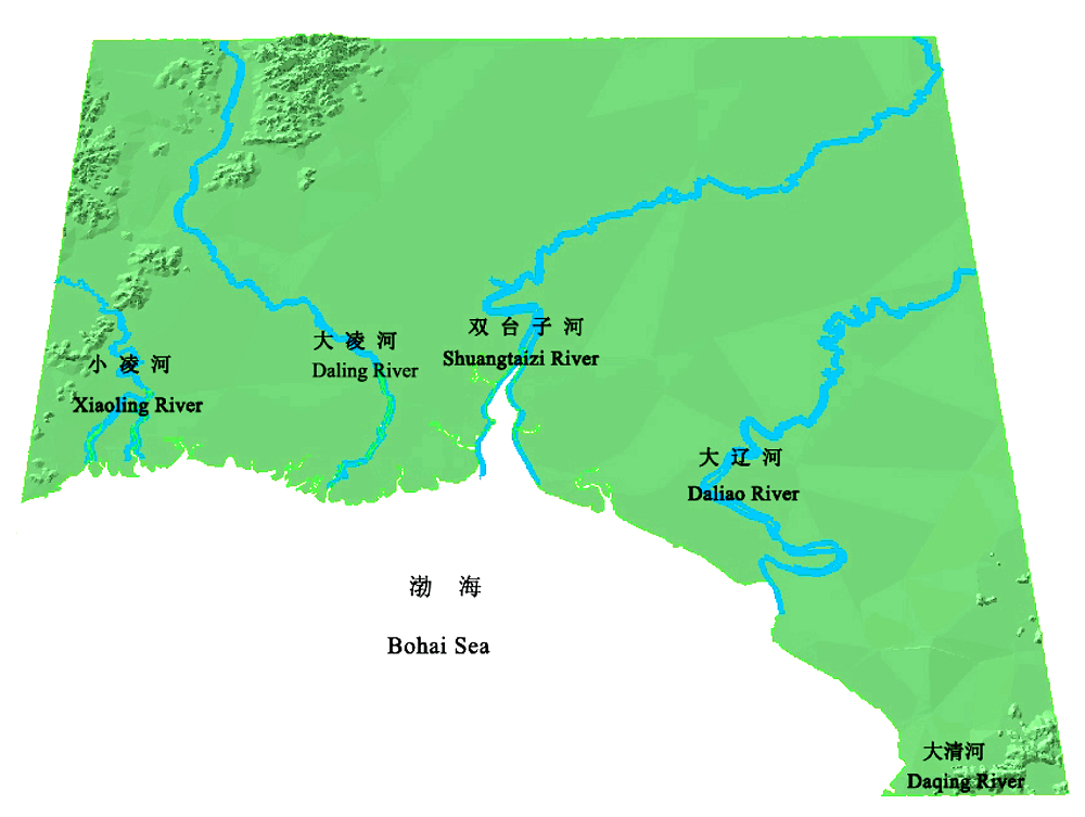
图1 辽河三角洲的地理范围: 东至大清河口, 西至小凌河口, 南至渤海, 北至盘锦市最北端。
Fig. 1 The geographical location of the Liaohe Delta: east extremely to the estuary of Daqinghe river; west extremely to the estuary of Xiaolinghe river; south extremely to Bohai Sea; north extremely to the northernmost region of Panjin.
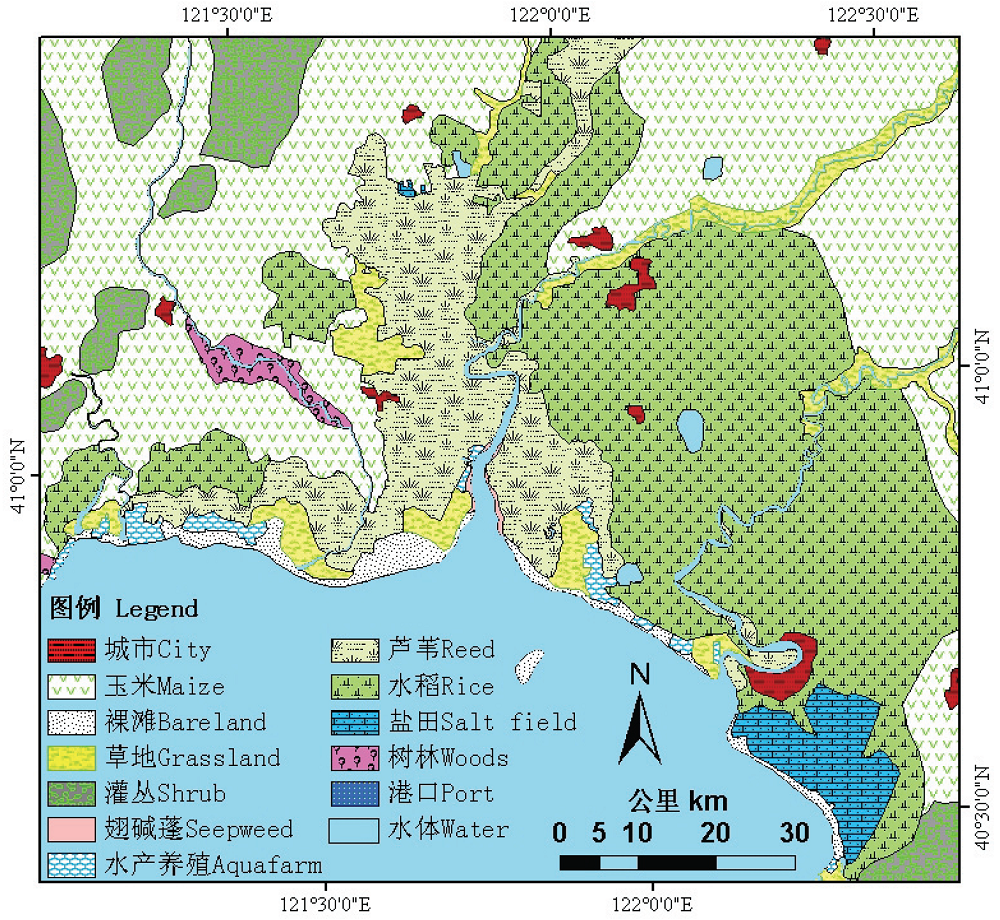
图2 1988年辽河三角洲地区的植被空间分布图。
Fig. 2 The spatial distribution map of vegetation in the Liaohe Delta in 1988.
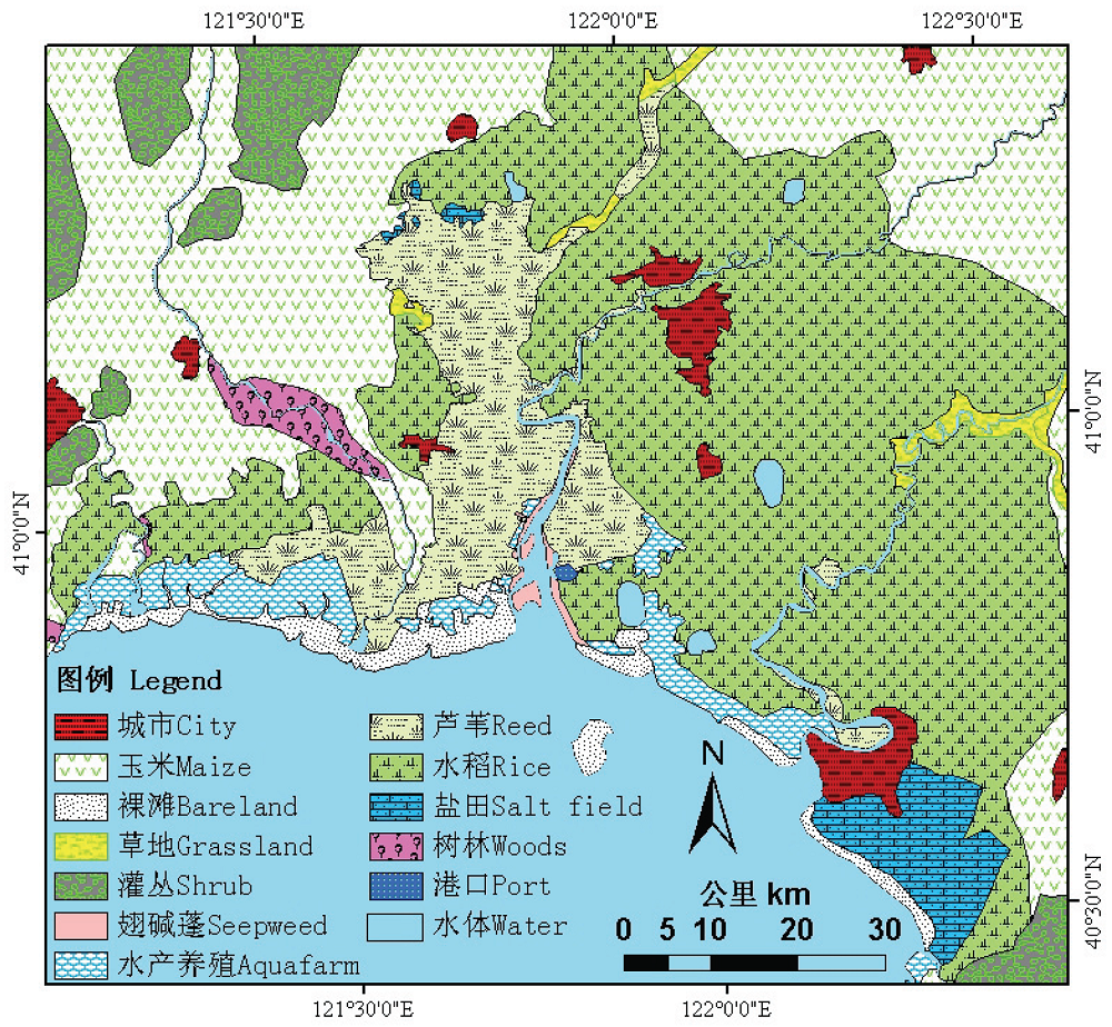
图3 2006年辽河三角洲地区的植被空间分布图。
Fig. 3 The spatial distribution map of vegetation in the Liaohe Delta in 2006.
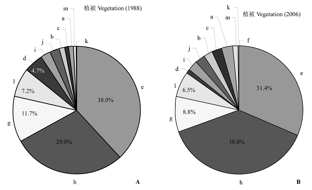
图4 1988年(A)和2006年(B)辽河三角洲植被面积比例图。 a, 水产养殖场; b, 裸滩; c, 城市; d, 草地; e, 玉米地; f, 港口; g, 滨海芦苇湿地; h, 水稻田; i, 河湖; j, 盐田; k, 翅碱蓬盐化草甸; l, 灌丛; m, 树林。
Fig. 4 The proportion map of vegetation types in the Liaohe Delta in 1988 (A) and 2006 (B). a, aquafarm; b, bareland; c, city; d, grassland; e, maize land; f, port; g, coastal wetland reed; h, rice land; i, river and lake; j, salt field; k, salt meadow seepweed; l, shrub; m, woods.
| 类型 Type | 1988 | 2006 | ||||||
|---|---|---|---|---|---|---|---|---|
| 面积 Area (km2) | 比例 Percentage (%) | 面积 Area (km2) | 比例 Percentage (%) | 变化面积 Changed area (km2) | 变幅 Changed rate (%) | |||
| 玉米地 Maize land | 3 860.8 | 27.84 | 3 238.6 | 23.36 | -622.2 | -16.1 | ||
| 海洋 Sea | 3 712.0 | 26.77 | 3 549.0 | 25.59 | -163.0 | -4.4 | ||
| 水稻田 Rice land | 2 942.9 | 21.22 | 3 920.0 | 28.27 | 977.1 | 33.2 | ||
| 滨海芦苇湿地 Coastal wetland reed | 1 188.2 | 8.57 | 912.6 | 6.58 | -275.6 | -23.2 | ||
| 灌丛 Shrub | 732.4 | 5.28 | 670.4 | 4.83 | -62.0 | -8.5 | ||
| 草地 Grassland | 474.6 | 3.42 | 104.9 | 0.76 | -369.7 | -77.9 | ||
| 河湖 River and lake | 262.8 | 1.90 | 265.8 | 1.92 | 3.0 | 1.1 | ||
| 盐田 Salt field | 228.7 | 1.65 | 258.5 | 1.86 | 29.8 | 13.0 | ||
| 裸滩 Bare land | 158.4 | 1.14 | 219.5 | 1.58 | 61.1 | 38.6 | ||
| 城市 City | 119.1 | 0.86 | 259.8 | 1.87 | 140.7 | 118.1 | ||
| 水产养殖场 Aquafarm | 91.3 | 0.66 | 326.7 | 2.36 | 235.4 | 257.8 | ||
| 树林 Woods | 86.0 | 0.62 | 107.0 | 0.77 | 21.0 | 24.4 | ||
| 翅碱蓬盐化草甸 Salt meadow seepweed | 9.1 | 0.07 | 28.4 | 0.20 | 19.3 | 212.1 | ||
| 港口 Port | 0 | 0 | 5.1 | 0.04 | 5.1 | |||
| 总计 Total | 13 866.3 | 100 | 13 866.3 | 100 | ||||
表1 1988-2006年辽河三角洲的植被面积及其变化幅度
Table 1 The area and the transformation rate of vegetation types in the Liaohe Delta from1988 to 2006
| 类型 Type | 1988 | 2006 | ||||||
|---|---|---|---|---|---|---|---|---|
| 面积 Area (km2) | 比例 Percentage (%) | 面积 Area (km2) | 比例 Percentage (%) | 变化面积 Changed area (km2) | 变幅 Changed rate (%) | |||
| 玉米地 Maize land | 3 860.8 | 27.84 | 3 238.6 | 23.36 | -622.2 | -16.1 | ||
| 海洋 Sea | 3 712.0 | 26.77 | 3 549.0 | 25.59 | -163.0 | -4.4 | ||
| 水稻田 Rice land | 2 942.9 | 21.22 | 3 920.0 | 28.27 | 977.1 | 33.2 | ||
| 滨海芦苇湿地 Coastal wetland reed | 1 188.2 | 8.57 | 912.6 | 6.58 | -275.6 | -23.2 | ||
| 灌丛 Shrub | 732.4 | 5.28 | 670.4 | 4.83 | -62.0 | -8.5 | ||
| 草地 Grassland | 474.6 | 3.42 | 104.9 | 0.76 | -369.7 | -77.9 | ||
| 河湖 River and lake | 262.8 | 1.90 | 265.8 | 1.92 | 3.0 | 1.1 | ||
| 盐田 Salt field | 228.7 | 1.65 | 258.5 | 1.86 | 29.8 | 13.0 | ||
| 裸滩 Bare land | 158.4 | 1.14 | 219.5 | 1.58 | 61.1 | 38.6 | ||
| 城市 City | 119.1 | 0.86 | 259.8 | 1.87 | 140.7 | 118.1 | ||
| 水产养殖场 Aquafarm | 91.3 | 0.66 | 326.7 | 2.36 | 235.4 | 257.8 | ||
| 树林 Woods | 86.0 | 0.62 | 107.0 | 0.77 | 21.0 | 24.4 | ||
| 翅碱蓬盐化草甸 Salt meadow seepweed | 9.1 | 0.07 | 28.4 | 0.20 | 19.3 | 212.1 | ||
| 港口 Port | 0 | 0 | 5.1 | 0.04 | 5.1 | |||
| 总计 Total | 13 866.3 | 100 | 13 866.3 | 100 | ||||
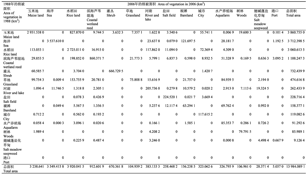 |
表2 1988-2006年辽河三角洲的植被转移矩阵
Table 2 The transfer matrix of vegetation types in the Liaohe Delta from 1988 to 2006
| |
| [1] |
Alados CL, Pueyo Y, Navas D, Cabezudo B, Gonzalez A, Freeman DC (2005). Fractal analysis of plant spatial patterns: a monitoring tool for vegetation transition shifts. Biodiversity and Conservation, 14, 1453-1468.
DOI URL |
| [2] |
Apan AA, Raine SR, Paterson MS (2002). Mapping and analysis of changes in the riparian landscape structure of the Lockyer Valley catchment Queensland, Australia. Landscape and Urban Planning, 59, 43-57.
DOI URL |
| [3] |
Bolliger J, Mladenoff DJ (2005). Quantifying spatial classification uncertainties of the historical Wisconsin landscape (USA). Ecography, 28, 141-156.
DOI URL |
| [4] |
Bresee MK, Moine JL, Mather S, Brosofske KD, Chen JQ, Crow TR, Rademacher J (2004). Disturbance and landscape dynamics in the Chequamegon National Forest Wisconsin, USA, from 1972 to 2001. Landscape Ecology, 19, 291-309.
DOI URL |
| [5] |
Capon SJ (2005). Flood variability and spatial variation in plant community composition and structure on a large arid floodplain. Journal of Arid Environments, 60, 283-302.
DOI URL |
| [6] | Cui HY (崔红艳) (2005). Risk analysis of potential sea-level rise base on GIS in Panjin. Journal of Jilin Normal University (吉林大学学报), (2), 5-7. (in Chinese with English abstract) |
| [7] | Dong HD (董厚德), Quan KG (全奎国), Shao C (邵成), Chen ZL (陈中林) (1995). Ecology of plant communities in Liaohe estuary wetland conservation area. Chinese Journal of Applied Ecology (应用生态学报), 6, 190-195. (in Chinese with English abstract) |
| [8] | Fu ZY (付在毅), Xu XG (许学工), Lin HP (林辉平), Wang XL (王宪礼) (2001). Regional ecological risk assessment in the Liaohe River Delta wetlands. Acta Ecologica Sinica (生态学报), 21, 365-373. (in Chinese with English abstract) |
| [9] |
Higinbotham CB, Alber M, Chalmers AG (2004). Analysis of tidal marsh vegetation patterns in two Georgia estuaries using aerial photography and GIS. Estuaries, 27, 670-683.
DOI URL |
| [10] | Huang GL (黄桂林), Zhang JJ (张建军), Han AH (韩爱慧), Zhang MX (张明祥), Zhang YW (张阳武), Dong K (董柯) (2000). The application of 3S technology in inspecting wetland. Forestry Resource Management (林业资源管理), (5), 51-56. (in Chinese) |
| [11] | Jiang WG (蒋卫国), Li J (李京), Wang WJ (王文杰), Xie ZR (谢志仁), Gong HL (宫辉力) (2005). An analysis of changes and driving forces of wetland using RS and GIS in Liaohe River Delta. Remote Sensing for Land & Resources (国土资源遥感), (3), 62-66. (in Chinese with English abstract) |
| [12] | Li J (李静), Zhao GX (赵庚星), Yang PG (杨佩国), Ma SH (马淑惠) (2008). Temporal-spatial characteristic of the land use and land cover change in the Yellow River Delta. Areal Research and Development (地域研究与开发), 27, 110-114. (in Chinese with English abstract) |
| [13] | Li JL (李加林), Zhao HB (赵寒冰), Cao YG (曹云刚), Liu C (刘闯) (2006). Analysis on change of landscape pattern of wetland in Liaohe Delta. Urban Environment & Urban Ecology (城市环境与城市生态), 19, 5-7. (in Chinese with English abstract) |
| [14] | Li XW (李晓文), Xiao DN (肖笃宁), Hu YM (胡远满) (2001). The landscape planning scenarios designing and the measures identification in the Liaohe River Delta wetland. Acta Ecologica Sinica (生态学报), 21, 353-365. (in Chinese with English abstract) |
| [15] | Li YC (2008). Land cover dynamic changes in northern China: 1989-2003. Journal of Geography Sciences, 18, 85-94. |
| [16] | Liu HY (刘红玉), Lü XG (吕宪国), Liu ZQ (刘振乾) (2001). Deltaic wetlands in Bohai Sea: resources and development. Journal of Natural Resources (自然资源学报), 16, 101-107. (in Chinese with English abstract) |
| [17] | Liu YF (刘岳峰), Wu L (邬伦), Hu YM (胡远满), Han MK (韩慕康), Ren JS (任劲松) (1998). Assessment of trend and impacts of sea level rise in the Liaohe River Delta. Acta Oceanologica Sinica (海洋学报), 20, 73-82. (in Chinese with English abstract) |
| [18] | Liu ZQ (刘振乾), Lü XG (吕宪国), Liu HY (刘红玉) (2000). Comparative study on wetlands in Huanghe and Liaohe Deltas. Resources Science (资源科学), 22(3), 60-65. (in Chinese with English abstract) |
| [19] | Liu ZQ (刘振乾), Xu XL (徐新良), Lü XG (吕宪国) (1999). The application of 3S technology in studying on wetland resource. Geography and Territorial Research (地理学与国土研究), 15, 87-91. (in Chinese) |
| [20] | Luan WX (栾维新), Cui HY (崔红艳) (2004). Submerged loss assessment of potential sea-level rise of Liao River Delta region based on GIS. Geographical Research (地理研究), 23, 805-814. (in Chinese with English abstract) |
| [21] | Luque SS (2000). Evaluating temporal changes using Multi-Spectral Scanner and Thematic Mapper data on the landscape of a natural reserve: the New Jersey Pine Barrens, a case study. Internal Journal of Remote Sensing, 21, 2589-2610. |
| [22] |
Petersen SL, Stringham TK (2008). Development of GIS-based models to predict plant community structure in relation to western juniper establishment. Forest Ecology and Management, 256, 981-989.
DOI URL |
| [23] |
Shirley LJ, Battaglia LL (2006). Assessing vegetation change in coastal landscapes of the Northern Gulf of Mexico. Wetlands, 26, 1057-1070.
DOI URL |
| [24] | Tang L (汤蕾), Xu D (许东), Mu XZ (母学征) (2006). Change in ecosystem service values in Liaohe River Delta. Research of Soil and Water Conservation (水土保持研究), 13(5), 108-110. (in Chinese with English abstract) |
| [25] |
Timoney K (2008). Rates of vegetation change in the Peace-Athabasca delta. Wetlands, 28, 513-520.
DOI URL |
| [26] |
Tong PHS, Auda Y, Populus J, Aizpuru M, Habshi AA, Blasco F (2004). Assessment from space of mangroves evolution in the Mekong Delta in relation to extensive shrimp farming. International Journal of Remote Sensing, 25, 4795-4812.
DOI URL |
| [27] |
Vogiatzakis IN, Griffiths GH (2006). A GIS-based empirical model for vegetation prediction in Lefka Ori, Crete. Plant Ecology, 184, 311-323.
DOI URL |
| [28] | Wang L (王凌), Li XZ (李秀珍), Guo DF (郭笃发) (2003). Land use change and consequences in the Liaohe Delta. Journal of Shandong Normal University (Natural Science) 山东师范大学学报(自然科学版)), 18(3), 43-47. (in Chinese with English abstract) |
| [29] | Wang XL (王宪礼), Bu RC (布仁仓), Hu YM (胡远满), Xiao DN (肖笃宁) (1996). Analysis on landscape fragment of Liaohe Delta Wetlands. Chinese Journal of Applied Ecology (应用生态学报), 7, 299-304. (in Chinese with English abstract) |
| [30] | Wu XP (吴晓莆), Tang ZY (唐志尧), Cui HT (崔海亭), Fang JY (方精云) (2006). Land cover dynamics of different topographic conditions in Beijing. Journal of Plant Ecology (Chinese Version) (植物生态学报), 30, 239-251. (in Chinese with English abstract) |
| [31] |
Wu JX, Cheng X, Xiao HS, Wang HQ, Yang LZ, Ellis EC (2009). Agricultural landscape change in China’s Yangtze Delta, 1942-2002: a case study. Agriculture, Ecosystems and Environment, 129, 523-533.
DOI URL |
| [32] | Xiao DN (肖笃宁) (1994). Natural resources and regional exploitation in the Liaohe River Delta. Journal of Natural Resources (自然资源学报), 9, 43-51. (in Chinese with English abstract) |
| [33] | Xiao DN (肖笃宁), Han MK (韩慕康), Li XW (李晓文), Liu YF (刘岳峰) (2003). Sea level rising around Bohai Sea and deltaic wetlands protection. Quaternary Sciences (第四纪研究), 23, 237-246. (in Chinese with English abstract) |
| [34] | Xiao DN (肖笃宁), Hu YM (胡远满), Li XZ (李秀珍) (2001). Landscape Ecology Research in the Deltaic Wetland Around Bohai Sea (环渤海三角洲湿地的景观生态学研究) 1st edn. Science Press, Beijing. 56-57. (in Chinese) |
| [35] |
Yang XJ (2005). Remote sensing and GIS applications for estuarine ecosystem analysis: an overview. International Journal of Remote Sensing, 26, 5347-5356.
DOI URL |
| [36] | Zhao Y (赵弈), Li YH (李月辉), Cao Y (曹宇) (2000). Flood prevention function of Panjin wetland at Liaohe Delta. Chinese Journal of Applied Ecology (应用生态学报), 11, 261-264. (in Chinese with English abstract) |
| [1] | 刘志祥, 黎凤兰, 黄晓磊. 昆虫虫瘿生态系统的复杂性及成瘿机制研究进展[J]. , 2027, 51(动植物互作): 0-. |
| [2] | 谭秋颜, 张清, 高程, 褚海燕, 杨腾. 外生菌根真菌: 高寒生态系统碳氮循环的关键驱动者[J]. 植物生态学报, 2026, 50(3): 584-599. |
| [3] | 马建辉, 童鑫, 张思榕, 毛子昆, 秦俊, 马克平. 菌根真菌生理生态功能研究进展及展望[J]. 植物生态学报, 2026, 50(3): 498-514. |
| [4] | 方迪, 马宁, 李胜功, 郑甲佳, 褚云馨, 杨锦昌, 杨赞明, 张龙宁, 孟盛旺, 高德才, 戴晓琴, 付晓莉, 王辉民, 寇亮. 菌根共生类型对森林养分内循环的调控作用[J]. 植物生态学报, 2026, 50(3): 552-565. |
| [5] | 张竟文, 李晶, 王汝苗, 王贺年, 崔丽娟. 不同纬度滨海湿地植物根系与土壤生态化学计量特征及内稳性分析[J]. 植物生态学报, 2026, 50(2): 461-473. |
| [6] | 冉佳鑫, 何舒婷, 罗素萍, 王云, 毛超. 森林土壤氮转化速率特征及其影响因素[J]. 植物生态学报, 2026, 50(1): 45-54. |
| [7] | 张琳, 陈华阳, 黄振英. 2004-2010年鄂尔多斯沙地草地长期监测样地植物物种组成和群落特征数据集[J]. 植物生态学报, 2025, 49(8): 1263-1270. |
| [8] | 王立龙, 冯静, 苏娜, 刘新平, 潘成臣, 李玉强. 2005-2015年科尔沁沙地典型农田生态系统长期监测样地玉米收获期性状和产量数据集[J]. 植物生态学报, 2025, 49(8): 1293-1300. |
| [9] | 周志琼, 丁建林, 李晓明, 何其华. 2005-2010年西南山地人工林长期监测样地植物物种组成与群落特征数据集[J]. 植物生态学报, 2025, 49(8): 1255-1262. |
| [10] | 王鹏, 李向义, 高艳菊, 热甫开提·沙比提, 曾凡江. 2005-2010年塔克拉玛干沙漠南缘绿洲农田长期监测样地棉花收获期性状和产量数据集[J]. 植物生态学报, 2025, 49(8): 1329-1338. |
| [11] | 朱喜, 何志斌, 杜明武, 赵丽雯, 吴丹丹. 2004-2010年河西走廊中段绿洲农田生态系统长期监测样地作物性状和产量数据集[J]. 植物生态学报, 2025, 49(8): 1312-1320. |
| [12] | 范亚冉, 夏少攀, 于冰冰, 朱紫琪, 杨威, 范豫川, 刘晓雨, 张旭辉, 郑聚锋. 大气CO2浓度升高和增温对土壤有机碳库积累、分子组成和结构稳定性的影响[J]. 植物生态学报, 2025, 49(7): 1053-1069. |
| [13] | 王尧, 王耀彬, 陈子彦, 伊如汉, 白永飞, 赵玉金, 金晶炜. 连续干旱对蒙古高原草地恢复力和抵抗力的影响[J]. 植物生态学报, 2025, 49(7): 1070-1081. |
| [14] | 李琳, 黄佳芳, 丁中浩, 郭萍萍, 蔡芫镔, 李诗华, 李云琴, 罗敏. 淹水高度增加对短叶茳芏潮汐湿地净生态系统CO2交换量的影响[J]. 植物生态学报, 2025, 49(4): 526-539. |
| [15] | 刘盈麟, 李春明, 王昊, 武长路, 贺强. 长江口滨海湿地水鸟对底栖微藻群落的营养级联效应[J]. 植物生态学报, 2025, 49(3): 367-378. |
| 阅读次数 | ||||||
|
全文 |
|
|||||
|
摘要 |
|
|||||
Copyright © 2026 版权所有 《植物生态学报》编辑部
地址: 北京香山南辛村20号, 邮编: 100093
Tel.: 010-62836134, 62836138; Fax: 010-82599431; E-mail: apes@ibcas.ac.cn, cjpe@ibcas.ac.cn
备案号: 京ICP备16067583号-19

