
Chin J Plant Ecol ›› 2012, Vol. 36 ›› Issue (6): 511-521.DOI: 10.3724/SP.J.1258.2012.00511 cstr: 32100.14.SP.J.1258.2012.00511
• Research Articles • Previous Articles Next Articles
SUN Xiao-Peng, WANG Tian-Ming*( ), KOU Xiao-Jun, GE Jian-Ping
Received:2012-02-13
Accepted:2012-04-11
Online:2012-02-13
Published:2012-06-04
Contact:
WANG Tian-Ming
SUN Xiao-Peng, WANG Tian-Ming, KOU Xiao-Jun, GE Jian-Ping. Normalized difference vegetation index dynamic change and its driving factor analysis with long time series in the Jinghe River watershed on the Loess Plateau of China[J]. Chin J Plant Ecol, 2012, 36(6): 511-521.
Add to citation manager EndNote|Ris|BibTeX
URL: https://www.plant-ecology.com/EN/10.3724/SP.J.1258.2012.00511
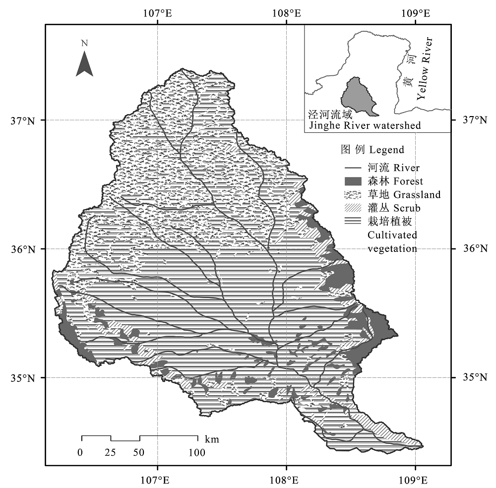
Fig. 1 The location and vegetation distribution of Jinghe River watershed (According to the Editorial Board of Vegetation Map of China, Chinese Academy of Sciences, 2001).
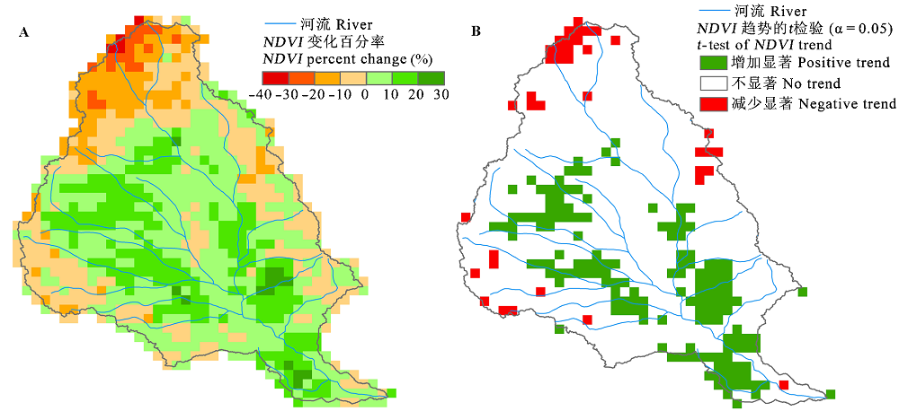
Fig. 2 Trend analysis (A) and significant test (B) of normalized difference vegetation index (NDVI) in Jinghe River watershed from 1982 to 2005.
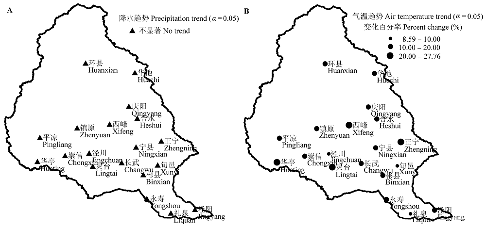
Fig. 3 Precipitation (A) and air temperature (B) trends of meteorological stations in Jinghe River watershed from 1982 to 2005.
| 站点编号 Station code | 站点名称 Station name | NDVI趋势 NDVI trend | 降水趋势 P trend | 气温趋势 T trend | 相关系数 Correlation coefficient | |
|---|---|---|---|---|---|---|
| rNDVI-P | rNDVI-T | |||||
| 53821 | 环县 Huanxian | - | + | +** | 0.6205* | -0.3899 |
| 53829 | 庆阳 Qingyang | + | - | +** | 0.3764 | -0.1807 |
| 53915 | 平凉 Pingliang | + | + | +** | 0.4417* | 0.0050 |
| 53923 | 西峰 Xifeng | + | + | +** | 0.3545 | -0.1672 |
| 53924 | 灵台 Lingtai | +* | - | +** | 0.4631* | 0.2400 |
| 53925 | 镇原 Zhenyuan | + | + | +** | 0.3725 | -0.0002 |
| 53926 | 泾川 Jingchuan | +** | - | +* | 0.4512* | 0.0367 |
| 53927 | 华亭 Huating | - | - | +** | 0.3920 | -0.4566* |
| 53928 | 崇信 Chongxin | + | + | +** | 0.5196* | 0.0073 |
| 53929 | 长武 Changwu | + | - | +** | 0.4392* | -0.1045 |
| 53930 | 华池 Huachi | - | + | +** | 0.3514 | -0.4181* |
| 53934 | 合水 Heshui | + | + | +** | 0.4352* | 0.0788 |
| 53935 | 正宁 Zhengning | + | - | +** | -0.0156 | 0.2346 |
| 53937 | 宁县 Ningxian | +* | - | +** | 0.4052* | 0.2305 |
| 53938 | 旬邑 Xunyi | +** | - | +* | 0.1580 | 0.1565 |
| 57023 | 彬县 Binxian | + | - | +** | 0.3563 | 0.0356 |
| 57029 | 礼泉 Liquan | + | - | +** | 0.2643 | 0.0235 |
| 57030 | 永寿 Yongshou | +** | - | +** | 0.0117 | 0.3140 |
| 57033 | 泾阳 Jingyang | - | - | +** | 0.1206 | -0.2314 |
Table 1 Trend analysis of the station buffer area in Jinghe River watershed
| 站点编号 Station code | 站点名称 Station name | NDVI趋势 NDVI trend | 降水趋势 P trend | 气温趋势 T trend | 相关系数 Correlation coefficient | |
|---|---|---|---|---|---|---|
| rNDVI-P | rNDVI-T | |||||
| 53821 | 环县 Huanxian | - | + | +** | 0.6205* | -0.3899 |
| 53829 | 庆阳 Qingyang | + | - | +** | 0.3764 | -0.1807 |
| 53915 | 平凉 Pingliang | + | + | +** | 0.4417* | 0.0050 |
| 53923 | 西峰 Xifeng | + | + | +** | 0.3545 | -0.1672 |
| 53924 | 灵台 Lingtai | +* | - | +** | 0.4631* | 0.2400 |
| 53925 | 镇原 Zhenyuan | + | + | +** | 0.3725 | -0.0002 |
| 53926 | 泾川 Jingchuan | +** | - | +* | 0.4512* | 0.0367 |
| 53927 | 华亭 Huating | - | - | +** | 0.3920 | -0.4566* |
| 53928 | 崇信 Chongxin | + | + | +** | 0.5196* | 0.0073 |
| 53929 | 长武 Changwu | + | - | +** | 0.4392* | -0.1045 |
| 53930 | 华池 Huachi | - | + | +** | 0.3514 | -0.4181* |
| 53934 | 合水 Heshui | + | + | +** | 0.4352* | 0.0788 |
| 53935 | 正宁 Zhengning | + | - | +** | -0.0156 | 0.2346 |
| 53937 | 宁县 Ningxian | +* | - | +** | 0.4052* | 0.2305 |
| 53938 | 旬邑 Xunyi | +** | - | +* | 0.1580 | 0.1565 |
| 57023 | 彬县 Binxian | + | - | +** | 0.3563 | 0.0356 |
| 57029 | 礼泉 Liquan | + | - | +** | 0.2643 | 0.0235 |
| 57030 | 永寿 Yongshou | +** | - | +** | 0.0117 | 0.3140 |
| 57033 | 泾阳 Jingyang | - | - | +** | 0.1206 | -0.2314 |
 |
Table 2 Changes of the land use types in no trend area, positive area and negative area of normalized diference vegetation index (NDVI)
| |
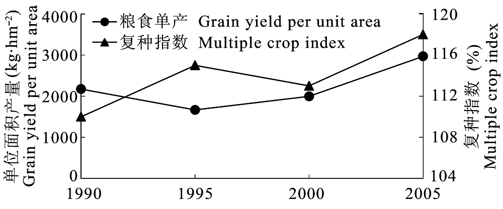
Fig. 4 Changes of grain yield per unit area and multiple crop index in Jinghe River watershed from 1990 to 2005 (According to Geng et al., 2008).
| [1] | Alves Senna MC, Costa MH, Chipponelli Pinto LI, Acioli Imbuzeiro HM, Freitas Diniz LM, Pires GF (2009). Challenges to reproduce vegetation structure and dynamics in amazonia using a coupled climate-biosphere model. Earth Interactions, 13(11), 1-28. |
| [2] | Anderson RG, Goulden ML (2011). Relationships between climate, vegetation, and energy exchange across a montane gradient. Journal of Geophysical Research- Biogeosciences, 116, G01026. |
| [3] |
Anyamba A, Tucker CJ (2005). Analysis of Sahelian vegetation dynamics using NOAA-AVHRR NDVI data from 1981-2003. Journal of Arid Environments, 63, 596-614.
DOI URL |
| [4] | Betts RA, Cox PM, Lee SE, Woodward FI (1997). Contrasting physiological and structural vegetation feedbacks in climate change simulations. Nature, 387, 796-799. |
| [5] | Bi XL ( 毕晓丽), Wang H ( 王辉), Zhou R ( 周睿), Hong J ( 洪军), Suo AN ( 索安宁), Ge JP ( 葛剑平) (2006). Analysis on the livestock capability of the Jinghe River basin on the Loess Plateau. Acta Ecologica Sinica (生态学报), 26, 4219-4224. (in Chinese with English abstract) |
| [6] |
Boelman NT, Stieglitz M, Griffin KL, Shaver GR (2005). Inter-annual variability of NDVI in response to long-term warming and fertilization in wet sedge and tussock tundra. Oecologia, 143, 588-597.
DOI URL PMID |
| [7] |
Chen CC ( 陈操操), Xie GD ( 谢高地), Zhen L ( 甄霖), Geng YH ( 耿艳辉), Leng YF ( 冷允法) (2008). Analysis on Jinghe watershed vegetation dynamics and evaluation on its relation with precipitation. Acta Ecologica Sinica (生态学报), 28, 925-938. (in Chinese with English abstract)
DOI URL |
| [8] | Chi HK ( 池宏康) (1995). A study on the model for estimation winter wheat yield using spectral data of wheat field. Acta Phytoecologica Sinica (植物生态学报), 19, 337-344. (in Chinese with English abstract) |
| [9] | Cramer W, Bondeau A, Woodward FI, Prentice IC, Betts RA, Brovkin V, Cox PM, Fisher V, Foley JA, Friend AD, Kucharik C, Lomas MR, Ramankutty N, Sitch S, Smith B, White A, Young-Molling C (2001). Global response of terrestrial ecosystem structure and function to CO2 and climate change: results from six dynamic global vegetation models. Global Change Biology, 7, 357-373. |
| [10] |
Diodato N, Bellocchi G (2008). Modelling vegetation greenness responses to climate variability in a mediterranean terrestrial ecosystem. Environmental Monitoring and Assessment, 143, 147-159.
URL PMID |
| [11] | Duchemin B, Guyon D, Lagouarde JP (1999). Potential and limits of NOAA-AVHRR temporal composite data for phenology and water stress monitoring of temperate forest ecosystems. International Journal of Remote Sensing, 20, 895-917. |
| [12] | Editorial Board of Vegetation Map of China, Chinese Academy of Sciences (中国科学院中国植被图编辑委员会) (2001). 1: 1000000 Vegetation Atlas of China (1: 1000000中国植被图集). Science Press, Beijing. (in Chinese) |
| [13] | Esteban-Parra MJ, Rodrigo FS, Castro-Diez Y (1998). Spatial and temporal patterns of precipitation in spain for the period 1880-1992. International Journal of Climatology, 18, 1557-1574. |
| [14] |
Evans J, Geerken R (2004). Discrimination between climate and human-induced dryland degradation. Journal of Arid Environments, 57, 535-554.
DOI URL |
| [15] |
Fuller DO (1998). Trends in NDVI time series and their relation to rangeland and crop production in Senegal, 1987-1993. International Journal of Remote Sensing, 19, 2013-2018.
DOI URL |
| [16] | Geng CX ( 耿春香), Zhang XX ( 张秀霞) (2003). Affecting factors analyze for ecological environment of oil field exploit in the Northwest. Environmental Protection Science (环境保护科学), 29, 40-41. (in Chinese with English abstract) |
| [17] | Geng YH ( 耿艳辉), Min QW ( 闵庆文), Cheng SK ( 成升魁), Chen CC ( 陈操操) (2008). Temporal and spatial distribu- tion of cropland-population-grain system and pressure index on cropland in Jinghe watershed. Transactions of the Chinese Society of Agricultural Engineering (农业工程学报), 24(10), 68-73. (in Chinese with English abstract) |
| [18] |
Goward SN, Waring RH, Dye DG, Yang JL (1994). Ecological remote sensing at OTTER: satellite macroscale observa- tions. Ecological Applications, 4, 322-343.
DOI URL |
| [19] | Guo ZH ( 郭志华), Peng SL ( 彭少麟), Wang BS ( 王伯荪), Zhang Z ( 张征) (1999). Estimation of radiation absorption by Guangdong vegetation using GIS and RS. Acta Ecologica Sinica (生态学报), 19, 441-447. (in Chinese with English abstract) |
| [20] | Holben BN (1986). Characteristics of maximum-value composite images from temporal AVHRR data. Interna- tional Journal of Remote Sensing, 7, 1417-1434. |
| [21] |
Jeong SJ, Ho CH, Park TW, Kim J, Levis S (2011). Impact of vegetation feedback on the temperature and its diurnal range over the Northern Hemisphere during summer in a 2 × CO2 climate. Climate Dynamics, 37, 821-833.
DOI URL |
| [22] | Jiang D ( 江东), Wang NB ( 王乃斌), Yang XH ( 杨小唤), Liu HH ( 刘红辉) (2002). Principles of the interaction between NDVI profile and the growing situation of crops. Acta Ecologica Sinica (生态学报), 22, 247-253. (in Chinese with English abstract) |
| [23] | Jobbagy EG, Sala OE, Paruelo JM (2002). Patterns and controls of primary production in the patagonian steppe: a remote sensing approach: regional ecological analysis. Ecology, 83, 307-319. |
| [24] | Kepner WG, Rubio JL, Mouat DA, Pedrazzini F (2006). Desertification in the Mediterranean Region: a Security Issue. Springer, Dordrecht, The Netherlands. 614. |
| [25] |
Law BE, Waring RH (1994). Remote-sensing of leaf area index and radiation intercepted by understory vegetation. Ecological Applications, 4, 272-279.
DOI URL |
| [26] | Li BG ( 李本纲), Tao S ( 陶澍) (2000). Correlation between AVHRR NDVI and climate factors. Acta Ecologica Sinica (生态学报), 20, 898-902. (in Chinese with English abstract) |
| [27] |
Liu JY, Zhang ZX, Xu XL, Kuang WH, Zhou WC, Zhang SW, Li RD, Yan CZ, Yu DS, Wu SX, Nan J (2010). Spatial patterns and driving forces of land use change in China during the early 21st century. Journal of Geographical Sciences, 20, 483-494.
DOI URL |
| [28] |
Liu XC, Xu ZX, Yu RH (2011). Trend of climate variability in China during the past decades. Climatic Change, 109, 503-516.
DOI URL |
| [29] |
Lucht W, Prentice IC, Myneni RB, Sitch S, Friedlingstein P, Cramer W, Bousquet P, Buermann W, Smith B (2002). Climatic control of the high-latitude vegetation greening trend and pinatubo effect. Science, 296, 1687-1689.
URL PMID |
| [30] |
Ma MG ( 马明国), Wang J ( 王建), Wang XM ( 王雪梅) (2006). Advance in the inter-annual variability of vegetation and its relation to climate based on remote sensing. Journal of Remote Sensing (遥感学报), 10, 421-431. (in Chinese with English abstract)
DOI URL |
| [31] | Milich L, Weiss E (2000). GAC NDVI images: relationship to rainfall and potential evaporation in the grazing lands of the gourma (northern Sahel) and in the croplands of the Niger-Nigeria border (southern Sahel). International Journal of Remote Sensing, 21, 261-280. |
| [32] |
Monteith JL (1981). Climatic variation and the growth of crops. Quarterly Journal of the Royal Meteorological Society, 107, 749-774.
DOI URL |
| [33] |
Morawitz DF, Blewett TM, Cohen A, Alberti M (2006). Using NDVI to assess vegetative land cover change in central Puget Sound. Environmental Monitoring and Assessment, 114, 85-106.
URL PMID |
| [34] |
Nemani RR, Keeling CD, Hashimoto H, Jolly WM, Piper SC, Tucker CJ, Myneni RB, Running SW (2003). Climate- driven increases in global terrestrial net primary production from 1982 to 1999. Science, 300, 1560-1563.
URL PMID |
| [35] |
Ostwald M, Chen DL (2006). Land-use change: impacts of climate variations and policies among small-scale farmers in the Loess Plateau, China. Land Use Policy, 23, 361-371.
DOI URL |
| [36] | Piao SL, Fang JY, Ji W, Guo QH, Ke JH, Tao S, Woods K (2004). Variation in a satellite-based vegetation index in relation to climate in China. Journal of Vegetation Science, 15, 219-226. |
| [37] | Qi Q ( 齐清), Wang TM ( 王天明), Kou XJ ( 寇晓军), Ge JP ( 葛剑平) (2009). Temporal and spatial changes of vegetation cover and the relationship with precipitation in Jinghe Watershed of China. Chinese Journal of Plant Ecology (植物生态学报), 33, 246-253. (in Chinese with English abstract) |
| [38] |
Slayback DA, Pinzon JE, Los SO, Tucker CJ (2003). Northern hemisphere photosynthetic trends 1982-99. Global Change Biology, 9, 1-15.
DOI URL |
| [39] | Sun XZ ( 孙新章), Xie GD ( 谢高地), Zhen L ( 甄霖) (2007). Effects of converting arable land into forest (grassland) and eco-compensation: a case study in Yuanzhou County, Guyuan City of Ningxia Hui Autonomous Region. Resources Science (资源科学), 29(2), 194-200. (in Chinese with English abstract) |
| [40] | Suo AN ( 索安宁), Zhao WZ ( 赵文喆), Wang TM ( 王天明), Yuan F ( 袁飞), Xiong Y ( 熊颖), Ge JP ( 葛剑平) (2007). Spatial-temporal succession characteristics of soil and water loss in the central Loess Plateau during the last 50 years. Journal of Beijing Forestry University (北京林业大学学报), 29(1), 90-97. (in Chinese with English abstract) |
| [41] | Tottrup C, Rasmussen MS (2004). Mapping long-term changes in savannah crop productivity in Senegal through trend analysis of time series of remote sensing data. Agriculture, Ecosystems and Environment, 103, 545-560. |
| [42] |
Verburg PH (2006). Simulating feedbacks in land use and land cover change models. Landscape Ecology, 21, 1171-1183.
DOI URL |
| [43] |
Vermote E, Saleoup NE, Kaufman YJ, Duttonc E (1997). Data pre-processing: stratospheric aerosol perturbing effect on the remote sensing of vegetation: correction method for the composite NDVI after the pinatubo eruption. Remote Sensing Reviews, 15, 7-21.
DOI URL |
| [44] | Vermote EF, Saleous NE (1995). Stratospheric aerosol perturb- ing effect on the remote sensing of vegetation: operational method for the correction of AVHRR composite NDVI. Atmospheric Sensing and Modelling, 2311, 19-29. |
| [45] | Wang CY ( 王长耀), Luo CF ( 骆成凤), Qi SH ( 齐述华), Niu Z ( 牛铮) (2005). A method of land cover classification for China based on NDVI-Ts space. Journal of Remote Sensing (遥感学报), 9, 93-99. (in Chinese with English abstract) |
| [46] | Wang TY ( 王天永) (1993). Potential danger and prevention countermeasures of soil erosion in Liupanshan and Ziwuling woodland. Soil and Water Conservation in China (中国水土保持), 7, 46-48. (in Chinese) |
| [47] | Wessels KJ, Prince SD, Malherbe J, Small J, Frost PE, VanZyl D (2007). Can human-induced land degradation be distinguished from the effects of rainfall variability? A case study in South Africa. Journal of Arid Environments, 68, 271-297. |
| [48] |
Wessels KJ, Prince SD, Zambatis N, MacFadyen S, Frost PE, VanZyl D (2006). Relationship between herbaceous biomass and 1-km 2 Advanced Very High Resolution Radiometer (AVHRR) NDVI in Kruger National Park, South Africa. International Journal of Remote Sensing, 27, 951-973.
DOI URL |
| [49] | Xie GD ( 谢高地), Zhen L ( 甄霖), Chen CC ( 陈操操), Yang L ( 杨丽) (2007). The changes and their interactions of precipitation-landscape-runoff in Jinghe Watershed. Resources Science (资源科学), 29(2), 156-163. (in Chinese with English abstract) |
| [50] |
Xie GD ( 谢高地), Zhen L ( 甄霖), Yang L ( 杨丽), Guo GM ( 郭广猛) (2005). Landscape stability and its pattern transition in Jinghe Watershed. Chinese Journal of Applied Ecology (应用生态学报), 16, 1693-1698. (in Chinese with English abstract)
URL PMID |
| [51] | Xin ZB ( 信忠保), Xu JX ( 许炯心) (2007). Response of spatio-temporal variation of vegetation cover to climate change in Loess Plateau. Progress in Natural Science (自然科学进展), 17, 770-778. (in Chinese) |
| [52] | Xin ZB ( 信忠保), Xu JX ( 许炯心), Zheng W ( 郑伟) (2007). Effect of climate change and human activities on the vegetation cover in Loess Plateau. Science in China (Series D: Earth Sciences) (中国科学(D辑: 地球科学)), 37, 1504-1514. (in Chinese) |
| [53] | Yang L ( 杨丽), Xie GD ( 谢高地), Zhen L ( 甄霖), Leng YF ( 冷允法), Guo GM ( 郭广猛) (2005). Spatio-temporal changes of land use in Jinghe Watershed. Resources Science (资源科学), 27(4), 26-32. (in Chinese with English abstract) |
| [54] | Zhen L ( 甄霖), Xie GD ( 谢高地), Yang L ( 杨丽), Chen CC ( 陈操操), Guo GM ( 郭广猛), Liu XL ( 刘雪林) (2007a). Interactions between human activities and landuse patterns, and conflicts at the village level of Jinghe Watershed. Resources Science (资源科学), 29(2), 201-207. (in Chinese with English abstract) |
| [55] | Zhen L ( 甄霖), Xie GD ( 谢高地), Yang L ( 杨丽), Cheng SK ( 成升魁) (2007b). Challenges facing landscape manage- ment in the Jinghe Watershed of northwestern China by using participatory rural appraisal. China Population Resources and Environment (中国人口·资源与环境), 17(3), 129-133. (in Chinese with English abstract) |
| [1] | Cao Yi-fei, Su Tao, Cao Min, Wang Hai-yan, Yang Jie. Drivers of Cenozoic Angiosperm Leaf Vein Density Evolution: Climate Adaptation and Herbivory Pressure [J]. , 2027, 51(动植物互作): 0-. |
| [2] | TAN Qiu-Yan, ZHANG Qing, GAO Cheng, CHU Hai-Yan, YANG Teng. Ectomycorrhizal fungi: key drivers of carbon and nitrogen cycling in alpine ecosystems [J]. Chin J Plant Ecol, 2026, 50(3): 584-599. |
| [3] | ZHENG Zi-Yi, CHEN Jiang-Hui, LIU Hui-Ying. Climate warming increases root exudation rates of dominant species in alpine meadow on the Qingzang Plateau [J]. Chin J Plant Ecol, 2025, 49(9): 1363-1373. |
| [4] | CHANG Peng-Fei, LI Ping, Nairsag , WANG Jing, WANG Zhen-Hua, YANG Sen, JIA Zhou, YANG Lu, LIU Ling-Li, DENG Mei-Feng. Contributions of soil organic carbon and inorganic carbon stocks to total soil carbon stock and their driving factors across different types in Nei Mongol temperate grasslands [J]. Chin J Plant Ecol, 2025, 49(9): 1374-1387. |
| [5] | ZHANG Lin, YUAN Wei-Ying, SONG Chuang-Ye, WU Dong-Xiu. Dynamic dataset of environmental elements, species richness and biomass of long-term observation plots of typical ecosystems in China from 1998 to 2010 [J]. Chin J Plant Ecol, 2025, 49(8): 1182-1190. |
| [6] | FAN Ya-Ran, XIA Shao-Pan, YU Bing-Bing, ZHU Zi-Qi, YANG Wei, FAN Yu-Chuan, LIU Xiao-Yu, ZHANG Xu-Hui, ZHENG Ju-Feng. Effects of elevated atmospheric CO2 concentration and warming on stability of soil organic carbon pool accumulation, molecular composition and structure stability [J]. Chin J Plant Ecol, 2025, 49(7): 1053-1069. |
| [7] | LIU Bi-Ying, CHEN Zi-Hao, YUAN Si-Hao, ZHOU Ting. Common issues and technical references for diagram drawing in the compilation of vegetation monographs [J]. Chin J Plant Ecol, 2025, 49(6): 911-921. |
| [8] | QIAO Pei-Yang, GU Xiao-Xuan, LIU Chang-Xin, CAO Ze-Yu, ZHANG Ting-Ting, LIN Chen, CHEN Qin-Chang, PENG Xiu-Fan, CHEN Fei-Fei, LI Hua-Liang, CHEN Wei, CHEN Lu-Zhen. Damage to the mangrove forests in Dongzhaigang of Hainan caused by super typhoon “Yagi” [J]. Chin J Plant Ecol, 2025, 49(4): 540-551. |
| [9] | ZHOU Si-Qi, AI Ling, NI Xiang-Yin, WU Fu-Zhong, WU Qiu-Xia, ZHU Jing-Jing, ZHANG Xin-Ying. Global patterns and controls of variation in cellulose decomposition rates of plant litters [J]. Chin J Plant Ecol, 2025, 49(3): 393-403. |
| [10] | WANG Kun-Ying, QIU Gui-Fu, LIU Zi-He, MENG Jun, LIU Yu-Xuan, JIA Guo-Dong. Climate change regulate tree growth and intrinsic water use efficiency of Populus simonii at different levels of degradation [J]. Chin J Plant Ecol, 2025, 49(2): 343-355. |
| [11] | HUANG Mei-Hong, NIU Meng-Qiu, YANG Peng-Fei, LIN Jie, LIAO Zhou-Yu, CHEN Jian-Guo, XIANG Jian-Ying. Effects of temperature and burial depth on seedling emergence and growth of the alpine cushion plant Arenaria oreophila [J]. Chin J Plant Ecol, 2025, 49(12): 2092-2104. |
| [12] | HE Yi, ZHOU Jing, CHEN Chen, FANG Ting-Zhou, SU Jian, GAO Hao-Jie, CAO Jia-Hao, YANG Fei-Yu, FAN Qi-Bo, ZHU Le-Yao, CHEN Yi-Ming, YANG Fei, WANG Yi-Teng, FENG Lei, LIU Fei, LIANG Shuang, JIANG Ming-Kai, CHEN Jun, ZHAO Yun-Peng, CHEN Wei-Le, ZHAO Ying, HUANG Jian-Guo. Protection and restoration of endangered tree species on coastal islands of Zhejiang, China [J]. Chin J Plant Ecol, 2025, 49(10): 1583-1599. |
| [13] | DONG Yun-Tao, JIA Heng-Feng, YANG Jing, LI Pei-Xuan, FANG Ou-Ya. Reconstruction of disturbance history on Juniperus przewalskii forests in middle Qilian Mountains [J]. Chin J Plant Ecol, 2024, 48(8): 967-976. |
| [14] | LI Shi-Jie, WANG Li, DU Ying-Jun, ZHENG Lei, ZENG Fan-Suo, XIN Ying. Radial growth response of natural Fraxinus mandshurica to climate in the Changbai Mountains [J]. Chin J Plant Ecol, 2024, 48(8): 1011-1020. |
| [15] | ZHANG Peng, JIAO Liang, XUE Ru-Hong, WEI Meng-Yuan, DU Da-Shi, WU Xuan, WANG Xu-Ge, LI Qian. Drought intensity affected the growth recovery of Picea crassifolia across different altitudes in western Qilian Mountains [J]. Chin J Plant Ecol, 2024, 48(8): 977-987. |
| Viewed | ||||||
|
Full text |
|
|||||
|
Abstract |
|
|||||
Copyright © 2026 Chinese Journal of Plant Ecology
Tel: 010-62836134, 62836138, E-mail: apes@ibcas.ac.cn, cjpe@ibcas.ac.cn
![]()